ATLAS of ANTIENT GEOGRAPHY by SAMUEL BUTLER 1843John McInnis Auctioneers,LLC4.6(502)See Sold PriceFeb 24, 2024
18TH C. ANTIQUE MAP: FRENCH & INDIAN WAR, FRAMEDThomaston Place Auction Galleries4.4(386)See Sold PriceFeb 24, 2024
Rand McNally Railroad Map Cabinet w/ 21 Railroad MapsRail & Road Auctions4.6(165)See Sold PriceMar 08, 2024
Keith Haring - Ink on New York Map, Best Buddies, Inscribed, Signed, and DatedSapphire Auction Gallery4(67)See Sold PriceMar 02, 2024
LATE 17TH C. FRENCH MAP OF THE NEW WORLD BY ALEXIS-HUBERT JAILLOT (1632-1712)Thomaston Place Auction Galleries4.4(386)See Sold PriceFeb 24, 2024
Central Railroad of New Jersey Map of Sandy Hook Route-ca. 1903JM Hobby Supply and Railroad Artifact Auctions4.4(126)See Sold PriceFeb 24, 2024
Lot of Six Mixed Atlas Box Cars-HO Scale-New in BoxJM Hobby Supply and Railroad Artifact Auctions4.4(126)See Sold PriceFeb 25, 2024
Rand McNally/Santa Fe Railroad Map of Iowa-1912JM Hobby Supply and Railroad Artifact Auctions4.4(126)See Sold PriceFeb 24, 2024
NICOLAES VISSCHER (NETHERLANDS, 1618-1709) MAP OF THE NEW WORLDThomaston Place Auction Galleries4.4(386)See Sold PriceFeb 24, 2024
17TH C. WORLD MAP BY NICOLAES VISSCHER (NETHERLANDS, 1618-1709)Thomaston Place Auction Galleries4.4(386)See Sold PriceFeb 24, 2024
Lot of Six Mixed Atlas Cabooses-HO Scale-New in BoxJM Hobby Supply and Railroad Artifact Auctions4.4(126)See Sold PriceFeb 25, 2024
"British India, southern part". Malabar & CoromandelTITLE/CONTENT OF MAP: 'British India, southern part' A large detailed map of southern India showing British territories and Native States. The Malabar, Coromandel and Pirate coasts are marked. Part ofSee Sold Price
"British India, southern part". Malabar & CoromandelTITLE/CONTENT OF MAP: 'British India, southern part' A large detailed map of southern India showing British territories and Native States. The Malabar, Coromandel and Pirate coasts are marked. Part ofSee Sold Price
British India, Southern partEngraved for Thomson’s New General Atlas, London, 1815 50.5 cm 59.5 cm Geometric gray-lined octagonal cartouche. Original color (provinces); shaded mountain ranges. Much detail of interior, incSee Sold Price
"British India, southern part". Malabar & CoromandelTITLE/CONTENT OF MAP: 'British India, southern part' A large detailed map of southern India showing British territories and Native States. The Malabar, Coromandel and Pirate coasts are marked. Part ofSee Sold Price
"British India, southern part". Malabar & CoromandelTITLE/CONTENT OF MAP: 'British India, southern part' A large detailed map of southern India showing British territories and Native States. The Malabar, Coromandel and Pirate coasts are marked. Part ofSee Sold Price
"British India, southern part". Malabar & CoromandelTITLE/CONTENT OF MAP: 'British India, southern part' A large detailed map of southern India showing British territories and Native States. The Malabar, Coromandel and Pirate coasts are marked. Part ofSee Sold Price
British India, southern part. Malabar & CoromandelTITLE/CONTENT OF MAP: 'British India, southern part' A large detailed map of southern India showing British territories and Native States. The Malabar, Coromandel and Pirate coasts are marked. Part ofSee Sold Price
SoldIndia.- Thomson (John) British India, Southern Part;India.- Thomson (John) British India, Southern Part; British India, Northern Part; Hindoostan, three maps of India from Thomson's New General Atlas, the first two mentioned forming a two-sheet map ofSee Sold Price
Thomson: Antique Map of Southern British India 1817TITLE/CONTENT OF MAP: 'British India, southern part' A large detailed map of southern India showing British territories and Native States. The Malabar, Coromandel and Pirate coasts are marked. Part ofSee Sold Price
Thomson: Map of British India South/North, 1814British India Southern Part/British India Northern Part. A paired set of British India maps from Thomson's New General Atlas, both both beautifully detailed and colored. The Northern India map includeSee Sold Price
Thomson: Antique Map of British India, 1817TITLE/CONTENT OF MAP: 'British India, southern part' A large detailed map of southern India showing British territories and Native States. The Malabar, Coromandel and Pirate coasts are marked. Part ofSee Sold Price
Thomson: Antique Map of Southern British India, 1817British India, southern part' A large detailed map of southern India showing British territories and Native States. The Malabar, Coromandel and Pirate coasts are marked. Part of ceylon is shown. DateSee Sold Price
SoldThomson: Antique Map of British India, 1814Map: British India Southern Part/British India Northern Part Cartographer: Thomson Place & Date: Edinburgh / 1814/1817 Size: 24 1/8" x 22 5/8" Condition: overall age-toning and spotting; repaired spliSee Sold Price
Sold"British India, northern part" w/ Nepal & Cabul.TITLE/CONTENT OF MAP: 'British India, northern part // Nepaul // Cabul' A detailed map of Northern British India, Nepal, and the environs of Kabul. The supposed course of the "Gaggar" (Ghaggar or LuniSee Sold Price
"British India, northern part" w/ Nepal & Cabul.TITLE/CONTENT OF MAP: 'British India, northern part. Nepaul. Cabul' A detailed map of Northern British India, Nepal, and the environs of Kabul. The supposed course of the "Gaggar" (Ghaggar or Luni) riSee Sold Price
"British India, northern part" w/ Nepal & Cabul.TITLE/CONTENT OF MAP: 'British India, northern part. Nepaul. Cabul' A detailed map of Northern British India, Nepal, and the environs of Kabul. The supposed course of the "Gaggar" (Ghaggar or Luni) riSee Sold Price
SoldAmerican Militia Musket Constructed with British India Pattern Parts,American Militia Musket Constructed with British India Pattern Parts, early 19th century. Converted to percussion ignition, 39 1/8 in. barrel, .80 caliber barrel with ring decoration at the breech andSee Sold Price
Thomson: Antique Map of Northern British India, 1817British India, northern part. Nepaul. Cabul' A detailed map of Northern British India, Nepal, and the environs of Kabul. The supposed course of the "Gaggar" (Ghaggar or Luni) river is marked running tSee Sold Price
Thomson: Antique Map of Northern British India, 1817TITLE/CONTENT OF MAP: 'British India, northern part. Nepaul. Cabul' A detailed map of Northern British India, Nepal, and the environs of Kabul. The supposed course of the "Gaggar" (Ghaggar or Luni) riSee Sold Price
SoldA late 19th / early 20thC tole peinte twin handledA late 19th / early 20thC tole peinte twin handled strong box / document box with light turquoise / blue fitted interior with travel labels for British India Steamer - Mashobra, Southern Railway WaterSee Sold Price
SoldFramed Map of Southern & Northern British IndiaFramed Map of Southern & Northern British India. Professionally matted and framed map depicting southern and northern British India. Frame measures 28.5 inches x 59 inches.See Sold Price
SoldJohnson & Ward: Map of China, 1860Map: China Maker: Johnson & Ward Date: 1860 Origin: New York Size: 12.75 x 15.25 inches This excellent map of China with insets of Amoy and Canton of the lower part of British India is very detailed wSee Sold Price
SoldExcellent Rosewood Linen Press, ca. 1860,Excellent Rosewood Linen Press, ca. 1860, probably of British Colonial India origin, two part form, the case is composed of solid relief carved rosewood with some mahogany secondary wood, both upper aSee Sold Price
SoldIndia.- Homann Heirs. Citra Gangem hoc est OraeIndia.- Homann Heirs. Citra Gangem hoc est Orae Celeberrimae Malabar & Coromandel cum Adjacente Insula non Minus Celebratissima Ceylon..., map of the southern part of India and Sri Lanka, with coloniaSee Sold Price
18thC/earlier Durga-Large, Powerful Presence, South Indian, Very heavy SpiritualThe Buddha Gallery4.4(29)See Sold PriceMar 13, 2024
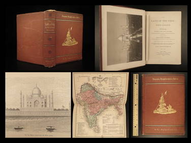
1872 INDIA Land of the Veda Travel Exploration Voyages Hindu Sepoy RebellionSchilb Antiquarian Rare Books4.8(421)See Sold PriceMar 31, 2024
1935 British India RPPC Postcard Cover to Purora CzechoslovakiaMynt Auctions4.6(680)See Sold PriceFeb 25, 2024
1932 Ireland Airmail First Flight Cover FFC Dublin to Bellary British IndiaMynt Auctions4.6(680)See Sold PriceFeb 26, 2024
1816 MAP SOUTHERN PART OF RUSSIA or MUSCOVY in EUROPE copper engraving ANTIQUEJasper524.5(9.8k)See Sold PriceFeb 27, 2024
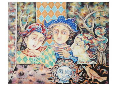
GOVIND SOLEGAONKAR (Sehore, Madhya Pradesh, British India, 1912-1986). "Abstract composition."Setdart Auction House4.1(22)See Sold PriceMar 05, 2024
Colonial Southern Africa. British Portuguese German. Madagascar. TIMES 1900 mapJasper524.5(9.8k)See Sold PriceFeb 28, 2024
MCI: THE MEINERTZHAGEN CARD INDEX ON NETSUKE IN THE ARCHIVES OF THE BRITISH MUSEUM OF ART. 2 VOLS. 1Toronto Book Auctions4.3(13)See Sold PriceMar 07, 2024
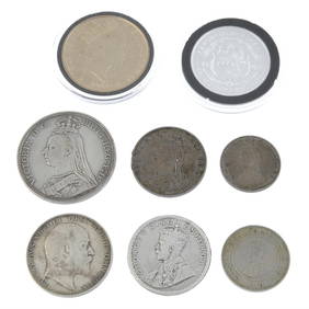
British India/China 2-Coin Set the First War on DrugsGolden Air Auctions4.4(257)See Sold PriceFeb 25, 2024
Franz Johann Joseph von Reilly - The southern part of the Bishopric of Liège or the country ofProverde Auctions4.3(3)See Sold PriceFeb 28, 2024
1906 India-British 1 Rupee KM# 508 ASW: 0.3438oz XF/AUAndrew's Coin & Jewelry4.5(209)See Sold PriceMar 07, 2024
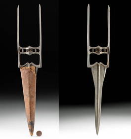
19th C. Indian Mughal Steel Katar w/ Leather SheathArtemis Fine Arts4.8(1.4k)See Sold PriceMar 01, 2024