ATLAS of ANTIENT GEOGRAPHY by SAMUEL BUTLER 1843John McInnis Auctioneers,LLC4.6(504)See Sold PriceFeb 24, 2024
18TH C. ANTIQUE MAP: FRENCH & INDIAN WAR, FRAMEDThomaston Place Auction Galleries4.4(389)See Sold PriceFeb 24, 2024
Rand McNally Railroad Map Cabinet w/ 21 Railroad MapsRail & Road Auctions4.6(165)See Sold PriceMar 08, 2024
Keith Haring - Ink on New York Map, Best Buddies, Inscribed, Signed, and DatedSapphire Auction Gallery4.1(67)See Sold PriceMar 02, 2024
LATE 17TH C. FRENCH MAP OF THE NEW WORLD BY ALEXIS-HUBERT JAILLOT (1632-1712)Thomaston Place Auction Galleries4.4(389)See Sold PriceFeb 24, 2024
Central Railroad of New Jersey Map of Sandy Hook Route-ca. 1903JM Hobby Supply and Railroad Artifact Auctions4.4(126)See Sold PriceFeb 24, 2024
Lot of Six Mixed Atlas Box Cars-HO Scale-New in BoxJM Hobby Supply and Railroad Artifact Auctions4.4(126)See Sold PriceFeb 25, 2024
Rand McNally/Santa Fe Railroad Map of Iowa-1912JM Hobby Supply and Railroad Artifact Auctions4.4(126)See Sold PriceFeb 24, 2024
NICOLAES VISSCHER (NETHERLANDS, 1618-1709) MAP OF THE NEW WORLDThomaston Place Auction Galleries4.4(389)See Sold PriceFeb 24, 2024
17TH C. WORLD MAP BY NICOLAES VISSCHER (NETHERLANDS, 1618-1709)Thomaston Place Auction Galleries4.4(389)See Sold PriceFeb 24, 2024
Lot of Six Mixed Atlas Cabooses-HO Scale-New in BoxJM Hobby Supply and Railroad Artifact Auctions4.4(126)See Sold PriceFeb 25, 2024
SoldTobias Lotter Map of New England 1776Tobias Conrad Lotter (1717-1777), "A Map of the Most Inhabited part of New England, containing the Provinces of Massachusets Bay and New Hampshire, with the Colonies of Conecticut and Rhode Island, DiSee Sold Price
SoldT.C. Lotter, Map of New England, 1776'A Map of the most Inhabited part of New England containing the Provinces of Massachusetts Bay and New Hampshire, with the Colonies of Connecticut and Rhode Island, Divided into Counties and TownshipsSee Sold Price
SoldLotter's map of New England c.1760Title: Recens Edita Totius Novi Belgii, in America Septentrionali Siti, Delineatio Cura et Sumtibus Tob. Conr. Lotteri ... August. Vind. Author:Lotter, Tobias Conrad Description:Copper-engraved map, hSee Sold Price
Lotter Map of New EnglandLOTTER, Tobias Conrad (1717 - 1777) and SEUTTER, Georg Mattaus Novi Belgii in America Septentrionali. Engraved map with hand color. Nuremburg: c. 1740. 25 1/2" x 22 sheet. Comparable: Christies, 2015See Sold Price
SoldLotter (Conrad Tobias) - Untitled map of parts of1 sheet (of four), from Lotter's 'A map of the most inhabited part of New England', engraved map, with hand-colouring, 520 x 490 mm., handling creases, minor spotting and browning, [Augsburg, circa 17See Sold Price
SoldLotter Map of New YorkLOTTER, Tobias Conrad (1717-1770). Recens Edita totius Novi Belgii... Engraved map with hand color in full. Augsburg, c.1760's. 20 3/4" x 24" sheet. Depicts New England from Chesapeake Bay to PenobscoSee Sold Price
SoldA Map of the Most Inhabited Part of New EnglandTobias Conrad Lotter Publisher, Augsburg 1775. Containing the Provinces of Massachusetts Bay and New Hampshire, with the Colonies of Connecticut and Rhode Island, Divided into Counties and Townships.See Sold Price
SoldLOTTER, TOBIAS CONRAD; after MEAD, BRADDOCK, aliasLOTTER, TOBIAS CONRAD; after MEAD, BRADDOCK, alias GREEN, JOHN. A Map of the Most Inhabited Part of New England, Containing the Provinces of Massachusets Bay and New Hampshire, with the Colonies of CoSee Sold Price
SoldLotter's version of Jeffery's New England 1776Title: A Map of the Most Inhabited Part of New England, Containing the Provinces of Massachusetts Bay and New Hampshire, with the Colonies of Connecticut and Rhode Island, Divided into Counties and ToSee Sold Price
Lotter's version of Jeffery's New England 1776Title: A Map of the Most Inhabited Part of New England, Containing the Provinces of Massachusets Bay and New Hampshire, with the Colonies of Conecticut and Rhode Island, Divided into Counties and TownSee Sold Price
SoldLOTTER, TOBIAS CONRAD. Pensylvania Nova Jersey et NewLOTTER, TOBIAS CONRAD. Pensylvania Nova Jersey et New York. Engraved map of eastern Pennsylvania, New Jersey, New York and parts of an amusingly condensed New England with a large decorative title carSee Sold Price
SoldLOTTERS MAP OF NEW ENGLAND INC. EARLY VIEW OF NYC 17TH17TH OR 18THC. 2ND OR 4TH STATE, BASED ON J. JANSSON MAP OF 1651 (19" X 22 3/8" PLATE SIZE)See Sold Price
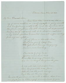
[Map] d'Anville, Canada and New England, 1776S. d'Anville - "Partie Orientale du Canada, avec la Nouvelle Angleterre, l'Acade, et la Terre Neuve" (Venice: Santini, 1776) engraving with light colored outlining, 19 1/4 X 23 1/4 in., plus margins.See Sold Price
1775 Lotter New England Map1775 A map of the most inhabited part of New England, containing the Provinces of Massachusetts Bay and New Hampshire, with the Colonies of Connecticut and Rhode Island, divided into counties and townSee Sold Price
MAP, New England & Mid-Atlantic US, SeutterColonial New England & Mid-Atlantic United States. Seutter/Lotter, Recens Edita Totius Novi Belgii, in America Septentrionali Siti, Delineatio Cura et Sumtibus, 1760 (circa). Hand Color. This dramaticSee Sold Price
SoldMAP OF NEW ENGLANDNouvelle Angleterre by Matthieu Albert Lotter, Augsburg. Impression/Paper size: 50 x 61.5 cm. (19 1/2 x 24 1/4 in.)See Sold Price
SoldAntique Map: New York & Area - EngravingPensylvania Nova Jersey et Nova York cum Regionibus Ad Fluvium Delaware In America Sitis, Nova Delinatione ob oculos posita...Tobias Conrad Lotter (1717 - 1777). Engraved map with hand-color in part.See Sold Price
Santini / d'Anville: Antique Map of Canada, New EnglandTitle/Content of Map: 'Partie Orientale du Canada avec la Nouvelle Angleterre, l'Acadie, et la Terre-Neuve. Par le S. d'Anville. À Venise par P. Santini 1776 [Eastern Canada with New England, Acadia,See Sold Price
MEAD - New England Map MA, NH, CT, RI [4 sheets] 1776MEAD, Braddock, alias John Green. A Map of the most Inhabited part of New England containing the Provinces of Massachusets Bay and New Hampshire, with the Colonies of Connecticut and Rhode Island, DivSee Sold Price
Pre-Revolutionary War era map of Pennsylvania, NewPensylvania Nova Jersey et Nova York cum Regionibus Ad Fluvium Delaware In America Sitis, Nova Delinatione ob oculos posita...Tobias Conrad Lotter (1717 - 1777). Engraved map with handcolor in part. ASee Sold Price
SoldLOTTER, TOBIAS CONRAD. Pennsylvania Nova Jersey et NovaLOTTER, TOBIAS CONRAD. Pennsylvania Nova Jersey et Nova York cum Regionibus ad Fluvium Delaware in America Sitis. Double-page engraved map of colonial Pennsylvania, New Jersey and New York with an elaSee Sold Price
Santini/d'Anville: Antique Map of "New France", 1784TITLE/CONTENT OF MAP: 'Partie Orientale du Canada avec la Nouvelle Angleterre, l'Acadie, et la Terre-Neuve. Par le S. d'Anville. À Venise par P. Santini 1776 [Eastern Canada with New England, Acadia,See Sold Price
1879 Wood Engraving Map, Boston & Environs 1775-1776Original 1879 book plate print, wood engraving, Boston Massachusetts, New England with it’s Environs in 1775 &1776. From "A Popular History of the United States." Published by Charles ScrSee Sold Price
"Partie Orientale du Canada" New England & MaritimesTITLE/CONTENT OF MAP: 'Partie Orientale du Canada avec la Nouvelle Angleterre, l'Acadie, et la Terre-Neuve. Par le S. d'Anville. À Venise par P. Santini 1776 [Eastern Canada with New England, Acadia,See Sold Price
BOTH TITLE PAGES OF COLLINS" COASTAL SURVEY, 1776, IN MATCHING FRAMESThomaston Place Auction Galleries4.4(389)See Sold PriceFeb 24, 2024
1849 THE NEW-ENGLAND MERCANTILE UNIONNorth American Artifact Auctions4.6(184)See Sold PriceApr 20, 2024
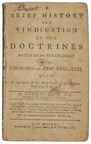
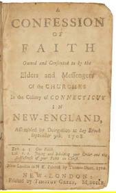
[MAP]. [ALBRIZZI, Giambatista, 1698-1777]. Carta Geografica...Potter & Potter Auctions4.6(544)See Sold PriceMar 07, 2024
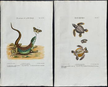
Edwards & Seligmann - 5 Engravings of Lizards, Snake, & Sea TurtleTrillium Antique Prints & Rare Books4.5(30)See Sold PriceFeb 24, 2024
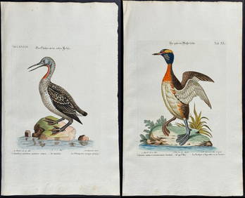
Edwards & Seligmann - Pair of Diver or Loon EngravingsTrillium Antique Prints & Rare Books4.5(30)See Sold PriceFeb 24, 2024
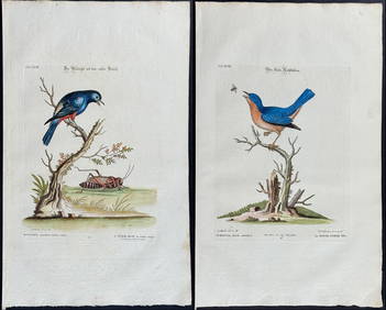
Edwards & Seligmann - 4 Bird EngravingsTrillium Antique Prints & Rare Books4.5(30)See Sold PriceFeb 24, 2024
Herman Moll A New Map of Ye North Parts of AmericaWillow Auction House4.5(284)See Sold PriceMar 14, 2024


![[Map] d'Anville, Canada and New England, 1776 (1 of 2)](https://p1.liveauctioneers.com/523/81971/42494506_1_x.jpg?height=282&quality=70&version=1447274451)


![MEAD - New England Map MA, NH, CT, RI [4 sheets] 1776 (1 of 5)](https://p1.liveauctioneers.com/7533/208644/106251145_1_x.jpg?height=282&quality=70&version=1626105036)


![[MAP]. [ALBRIZZI, Giambatista, 1698-1777]. Carta Geografica... (1 of 1)](https://p1.liveauctioneers.com/928/318880/171361280_1_x.jpg?height=282&quality=70&version=1707501302)