ATLAS of ANTIENT GEOGRAPHY by SAMUEL BUTLER 1843John McInnis Auctioneers,LLC4.5(505)See Sold PriceFeb 24, 2024
18TH C. ANTIQUE MAP: FRENCH & INDIAN WAR, FRAMEDThomaston Place Auction Galleries4.4(393)See Sold PriceFeb 24, 2024
Rand McNally Railroad Map Cabinet w/ 21 Railroad MapsRail & Road Auctions4.6(165)See Sold PriceMar 08, 2024
Keith Haring - Ink on New York Map, Best Buddies, Inscribed, Signed, and DatedSapphire Auction Gallery4(67)See Sold PriceMar 02, 2024
LATE 17TH C. FRENCH MAP OF THE NEW WORLD BY ALEXIS-HUBERT JAILLOT (1632-1712)Thomaston Place Auction Galleries4.4(393)See Sold PriceFeb 24, 2024
Central Railroad of New Jersey Map of Sandy Hook Route-ca. 1903JM Hobby Supply and Railroad Artifact Auctions4.4(127)See Sold PriceFeb 24, 2024
Lot of Six Mixed Atlas Box Cars-HO Scale-New in BoxJM Hobby Supply and Railroad Artifact Auctions4.4(127)See Sold PriceFeb 25, 2024
Rand McNally/Santa Fe Railroad Map of Iowa-1912JM Hobby Supply and Railroad Artifact Auctions4.4(127)See Sold PriceFeb 24, 2024
NICOLAES VISSCHER (NETHERLANDS, 1618-1709) MAP OF THE NEW WORLDThomaston Place Auction Galleries4.4(393)See Sold PriceFeb 24, 2024
17TH C. WORLD MAP BY NICOLAES VISSCHER (NETHERLANDS, 1618-1709)Thomaston Place Auction Galleries4.4(393)See Sold PriceFeb 24, 2024
Lot of Six Mixed Atlas Cabooses-HO Scale-New in BoxJM Hobby Supply and Railroad Artifact Auctions4.4(127)See Sold PriceFeb 25, 2024
Three Maps from Johnson & Ward, consisting of:Three Maps from Johnson & Ward, consisting of: "Indiana," 1864, hand colored, H.- 26 1/2 in., W.- 18 in.; together with two copies of Johnson & Ward, "Iowa and Nebraska," 1861 and 1864, hand colored,See Sold Price
SoldThree Maps: consisting of Johnson & Ward, "UnitedThree Maps: consisting of Johnson & Ward, "United States," 1864, hand colored, H.- 17 7/8 in., W.- 26 1/2 in.; together with two copies of Johnson & Ward, "North America," 1861-1863, H.- 26 1/2 in., WSee Sold Price
SoldTwo Maps by Johnson & Ward, consisting of "Ireland andTwo Maps by Johnson & Ward, consisting of "Ireland and Scotland," 1863-1866, hand colored, H.- 8 in., W.- 26 1/2 in.; together with "England and Wales," 1862, hand colored, H.- 26 1/2 in., W.- 18 in.See Sold Price
SoldTwo Maps by Johnson & Ward, consisting of "Venezuela,Two Maps by Johnson & Ward, consisting of "Venezuela, New Granada, Ecuador, Peru, Bolivia, Chile, and Guiana," 1867, hand colored, H.- 14 in., W.- 17 3/4 in.; together with "Brazil, Argentine RepublicSee Sold Price
SoldTwo Maps by Johnson & Ward, consisting of "Prussia,Two Maps by Johnson & Ward, consisting of "Prussia, Norway, Sweden, and Denmark," 19th c., hand colored, H.- 26 1/2 in., W.- 18 1/4 in.; together with Johnson & Ward, "West Indies," 1863-1866, hand coSee Sold Price
SoldFour Maps by Johnson & Ward, consisting of: "North andFour Maps by Johnson & Ward, consisting of: "North and South Carolina," 1862, hand colored, H.- 18 in., W.- 26 3/4 in.; "Arkansas, Mississippi, Louisiana," 1863, hand colored, H.- 26 1/2 in., W.- 18 iSee Sold Price
Three Maps by Johnson & Ward, Two "Virginia, Delaware,Three Maps by Johnson & Ward, Two "Virginia, Delaware, Maryland, West Virginia," one "Virginia, Delaware and Maryland," 1864, hand colored, H.- 18 in., W.- 27 3/4 in. (3 Pcs.)See Sold Price
SoldThree Maps by A. J. Johnson, consisting of "NewThree Maps by A. J. Johnson, consisting of "New Brunswick, Nova Scotia, Newfoundland, and Prince Edward Island," 1860-1863, hand colored, H.- 13 3/8 in., W.- 17 in.; "Prussia and Germany," 1866, handSee Sold Price
SoldTHREE MAPS OF ASIA AND HINDOSTAN (INDIA)Includes an 1816 Matthew Casey map of 'Asia, According to the best Authorities,' matted, 13.25 x 14.75 inch sight size; an 1863 unmatted Johnson & Ward map of 'Hindostan or British India,' 14 x 18 incSee Sold Price
SoldTHREE MAPS OF SOUTH AMERICA (VENEZUELA-PATAGONIA)Includes an unmatted Johnson and Ward 1863 map of 'Venezuela, New Granada, Ecuador, Peru and Bolivia, Chile and Guiana,' 14 x 18 inches. An 1836 map of 'Venezula, New Grenada and Equador,' professionaSee Sold Price
SoldFIFTEEN MAPS, SCENIC ENGRAVINGSMAPS, SCENIC ENGRAVINGS, 19th c.- 20th c: Three Johnson & Ward steele engraved maps c, 1865; John Tallis & Co. map of West India Islands; St. Goar on the Rhein, Germany; handcolored steele engraving,See Sold Price
SoldAN ANTIQUE MAP, "Johnson's New Map of the State ofAN ANTIQUE MAP, "Johnson's New Map of the State of Texas by Johnson and Ward," hand color and ink on paper, with three small maps of, "Plan of Sabine Lake," "Plan of the Northern Part of Texas," and "See Sold Price
SoldMap, "Johnson's North and South Carolina,"Map, "Johnson's North and South Carolina," (New York: Johnson & Ward, ca. 1860s), hand colored steel engraving from folio, fine details showing major roads and railroads, three insets include map of CSee Sold Price
Soldc. 1866 "Johnson's North and South Carolina" MapRare uncolored c. 1866 map by Johnson and Ward; fine details showing major roads and railroads; three inset views include "Plan of Charleston Vicinity & Harbor", "Table Mountain", and "Chimney Rocks aSee Sold Price
SoldRare Map "Johnson's North and South Carolina"Rare uncolored c. 1866 map by Johnson and Ward; fine details showing major roads and railroads; three inserts include map of Charleston Harbor, vignettes of Table Mountain, Chimney Rocks and French BrSee Sold Price
SoldTHREE 19TH CENTURY MAPS OF INDIANA AND OHIOIncludes a map of Indiana by Frank A. Gray, dated 1876, unmatted, 27 x 17.5 inches overall; an 1879 map of Ohio by Gray, 17.5 x 28.5 inches; and an 1863 Johnson and Ward map of Ohio and Indiana, 18 xSee Sold Price
SoldFive Maps: consisting of two copies of Johnson & Ward,Five Maps: consisting of two copies of Johnson & Ward, "Lower and Upper Canada," 1860-1863, hand colored, H.- 26 1/2 in., W.- 18 1/8 in.; together with two copies of Johnson & Ward, "Lower Canada & NeSee Sold Price
SoldJOHNSON AND WARD MAP OF MISSOURI AND KANSAS CIRCA 1860Map of Missouri in the eastern one third of Kansas circa 1860. Counties in color and three vignettes including spearing fish and fire on the Prairie. Measures 17.75 x 26.5 inches, frame measures 27 xSee Sold Price
Group of Three Maps, consisting of "Hawaii," 1905, byGroup of Three Maps, consisting of "Hawaii," 1905, by Rand McNally, matted and shrink wrapped; "Louisiana," by J. H. Colton, 1855, hand colored, matted and shrink wrapped; and "United States SouthernSee Sold Price
SoldGroup of Three Maps, consisting of "Hawaii," 1905, byGroup of Three Maps, consisting of "Hawaii," 1905, by Rand McNally, matted and shrink wrapped; "Louisiana," by J. H. Colton, 1855, hand colored, matted and shrink wrapped; and "United States SouthernSee Sold Price
Three Maps: consisting of U. S. Coast Survey, "SiberiaThree Maps: consisting of U. S. Coast Survey, "Siberia - Bering Sea, Kaliv Kresta to Mys Nygligan, 1932, H. - 34in., W. - 50 in.; together with two maps from the Hydrographic Offoce U. S. Navy, the fiSee Sold Price
SoldAntique World Maps (2)Double Hemisphere world map, Johnson & Ward, 1860s. Mercator's Projection world map, Colton, New York, 1855.See Sold Price
SoldTwo Maps by Johnson & Ward, "West Indies," 1864, handTwo Maps by Johnson & Ward, "West Indies," 1864, hand colored, H.- 17 7/8 in., W.- 26 1/2 in.; together with "South America," 1860, hand colored, H.- 26 1/2 in., W.- 18 1/4 in. (2 Pcs.)See Sold Price
SoldTwo Maps by Johnson & Ward, "Delaware and Maryland,"Two Maps by Johnson & Ward, "Delaware and Maryland," 1862, hand colored, H.- 13 1/2in., W.- 17 1/4 in.; together with "Map of the Vicinity of Richmond and Peninsular Campaign in Virginia," 1862, handSee Sold Price
Chinese School (Qing Dynasty, 1644-1911), Three Landscapes, H.- 13 in., W.- 7 3/4 in., Framed- H.-Crescent City Auction Gallery4.3(231)See Sold PriceMar 01, 2024
Group of Four Ninth Plate Photographs, 19th c., consisting of three tintypes of gentlemen withCrescent City Auction Gallery4.3(231)See Sold PriceMar 01, 2024
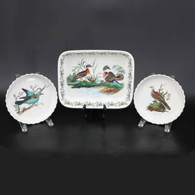
Group of Portmeirion English Pottery, Birds of Britain Pattern, Three Total PiecesNorthgate Gallery, Inc.4.5(36)See Sold PriceMar 02, 2024
An Assortment of Native American Artist Jewelry, Including Wilbur IuleHoch LTD.4.6(79)See Sold PriceFeb 25, 2024
Three Apothecary Cylinder Glass Jars Uranium GlassJudd's Auction Gallery, Inc. 4.6(166)See Sold PriceFeb 25, 2024
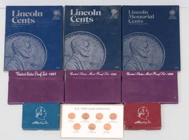
Lot of Collectible Coins & Lincoln Cents BooksOld Kinderhook Auction Company4.6(217)See Sold PriceMar 05, 2024
West Indies Islands. Guadaloupe. | Mariegalante &C. | Antigua.Jasper524.5(9.9k)See Sold PriceFeb 27, 2024
Hetian jade three treasures to ward off evil before Ming DynastyJapan Ancient Art Co. LTD4.4(45)See Sold PriceFeb 28, 2024
A GENTLEMANS DRINKING COMPENDIUM, consisting of three decanters, four glasses, and three sherry glasHannam's Auctioneers Ltd4.3(396)See Sold PriceFeb 27, 2024
Virginia and West Virginia Topography MapsRapid Estate Liquidators and Auction Gallery4.5(1.1k)See Sold PriceFeb 28, 2024