ATLAS of ANTIENT GEOGRAPHY by SAMUEL BUTLER 1843John McInnis Auctioneers,LLC4.5(505)See Sold PriceFeb 24, 2024
18TH C. ANTIQUE MAP: FRENCH & INDIAN WAR, FRAMEDThomaston Place Auction Galleries4.4(393)See Sold PriceFeb 24, 2024
Rand McNally Railroad Map Cabinet w/ 21 Railroad MapsRail & Road Auctions4.6(165)See Sold PriceMar 08, 2024
Keith Haring - Ink on New York Map, Best Buddies, Inscribed, Signed, and DatedSapphire Auction Gallery4(67)See Sold PriceMar 02, 2024
LATE 17TH C. FRENCH MAP OF THE NEW WORLD BY ALEXIS-HUBERT JAILLOT (1632-1712)Thomaston Place Auction Galleries4.4(393)See Sold PriceFeb 24, 2024
Central Railroad of New Jersey Map of Sandy Hook Route-ca. 1903JM Hobby Supply and Railroad Artifact Auctions4.4(127)See Sold PriceFeb 24, 2024
Lot of Six Mixed Atlas Box Cars-HO Scale-New in BoxJM Hobby Supply and Railroad Artifact Auctions4.4(127)See Sold PriceFeb 25, 2024
Rand McNally/Santa Fe Railroad Map of Iowa-1912JM Hobby Supply and Railroad Artifact Auctions4.4(127)See Sold PriceFeb 24, 2024
NICOLAES VISSCHER (NETHERLANDS, 1618-1709) MAP OF THE NEW WORLDThomaston Place Auction Galleries4.4(393)See Sold PriceFeb 24, 2024
17TH C. WORLD MAP BY NICOLAES VISSCHER (NETHERLANDS, 1618-1709)Thomaston Place Auction Galleries4.4(393)See Sold PriceFeb 24, 2024
Lot of Six Mixed Atlas Cabooses-HO Scale-New in BoxJM Hobby Supply and Railroad Artifact Auctions4.4(127)See Sold PriceFeb 25, 2024
SoldFour Maps by Johnson & Ward, consisting of: "North andFour Maps by Johnson & Ward, consisting of: "North and South Carolina," 1862, hand colored, H.- 18 in., W.- 26 3/4 in.; "Arkansas, Mississippi, Louisiana," 1863, hand colored, H.- 26 1/2 in., W.- 18 iSee Sold Price
SoldThree Maps: consisting of Johnson & Ward, "UnitedThree Maps: consisting of Johnson & Ward, "United States," 1864, hand colored, H.- 17 7/8 in., W.- 26 1/2 in.; together with two copies of Johnson & Ward, "North America," 1861-1863, H.- 26 1/2 in., WSee Sold Price
SoldTwo Maps by Johnson & Ward, consisting of "Ireland andTwo Maps by Johnson & Ward, consisting of "Ireland and Scotland," 1863-1866, hand colored, H.- 8 in., W.- 26 1/2 in.; together with "England and Wales," 1862, hand colored, H.- 26 1/2 in., W.- 18 in.See Sold Price
SoldTwo Maps by Johnson & Ward, consisting of "Venezuela,Two Maps by Johnson & Ward, consisting of "Venezuela, New Granada, Ecuador, Peru, Bolivia, Chile, and Guiana," 1867, hand colored, H.- 14 in., W.- 17 3/4 in.; together with "Brazil, Argentine RepublicSee Sold Price
SoldTwo Maps by Johnson & Ward, consisting of "Prussia,Two Maps by Johnson & Ward, consisting of "Prussia, Norway, Sweden, and Denmark," 19th c., hand colored, H.- 26 1/2 in., W.- 18 1/4 in.; together with Johnson & Ward, "West Indies," 1863-1866, hand coSee Sold Price
Three Maps from Johnson & Ward, consisting of:Three Maps from Johnson & Ward, consisting of: "Indiana," 1864, hand colored, H.- 26 1/2 in., W.- 18 in.; together with two copies of Johnson & Ward, "Iowa and Nebraska," 1861 and 1864, hand colored,See Sold Price
SoldFour Maps by A.J. Johnson, consisting of two copies ofFour Maps by A.J. Johnson, consisting of two copies of "Florida," 1863, hand colored, H.- 13 5/8 in., W.- 18 in.; together with two copies of "Arkansas, Mississippi,and Louisiana", 1866, hand colored,See Sold Price
SoldTwo Maps by A. J. Johnson, consisting of " NorthTwo Maps by A. J. Johnson, consisting of " North America," 1861, hand colored, h.- 27 in., W.- 18 1/8 in.; together with "Canada, East or Lower Canada and New Brunswick," 1863-1869, H.- 11 7/8 in., W.See Sold Price
ENGRAVED MAP - NORTH AMERICA, 19THCENGRAVED MAP - NORTH AMERICA, JOHNSON & WARD, 19TH CENTURY. 23 X 18"See Sold Price
SoldFOUR BOOKS FROM THE LEM WARD LIBRARY consisting ofFOUR BOOKS FROM THE LEM WARD LIBRARY consisting of “North American Birds of Prey,”by A. Sprunt, Jr., “Panther” by R. Caras, “The Painter’s Craft” by R. Mayer, and “Penguin Millionaire�See Sold Price
Map of North & Central America 109494Multi-color, double truck map of Johnson's North America by Johnson and Ward. Shows north from Mt. Franklin at the Polar Sea all the way south to Panama. This map is in good condition only 1 chip at lSee Sold Price
Johnson and Ward Atlas NORTH AMERICA Map, publisheJohnson’s NORTH AMERICA, published 1864. A beautiful antique map of the North America, published in the 1864 Johnson and Ward Atlas. Within the map, the United States is well formed by now but withSee Sold Price
CIVIL WAR ERA JOHNSON'S NORTH, SOUTH CAROLINA MAPFramed "Johnson's North and South Carolina Map", by Johnson & Ward (Alvin Jewett Johnson,1827-1884), c. 1862, the two states shown in colors with vignettes of Chimney Rocks and French Broad River, TabSee Sold Price
Soldc. 1866 "Johnson's North and South Carolina" MapRare uncolored c. 1866 map by Johnson and Ward; fine details showing major roads and railroads; three inset views include "Plan of Charleston Vicinity & Harbor", "Table Mountain", and "Chimney Rocks aSee Sold Price
SoldRare Map "Johnson's North and South Carolina"Rare uncolored c. 1866 map by Johnson and Ward; fine details showing major roads and railroads; three inserts include map of Charleston Harbor, vignettes of Table Mountain, Chimney Rocks and French BrSee Sold Price
North AmericaTitle/Content of Map: North America Date: 1863 Cartographer: By Johnson & Ward. From, Johnson’s New Illustrated Family Atlas Size: 18x26 1/4” Provenance: New York Additional Info: Hand colored. TeSee Sold Price
Johnson: Map of North America, 1862Johnson’s North America, Johnson & Ward, 1862. 16.75 x 22 inches. Interesting configuration of North America, particularly the United States, Canada and Mexico, just after the outbreak of the CivilSee Sold Price
SoldJohnson’s North America, Johnson & Ward, 1862Interesting configuration of North America, particularly the United States, Canada and Mexico, just after the outbreak of the Civil War. States roughly follow the 1861 configuration with archaic bordeSee Sold Price
Johnson’s North America, Johnson & Ward, 1862Reserve Reduced! Interesting configuration of North America, particularly the United States, Canada and Mexico, just after the outbreak of the Civil War. States roughly follow the 1861 configuration wSee Sold Price
SoldFive Maps: consisting of two copies of Johnson & Ward,Five Maps: consisting of two copies of Johnson & Ward, "Lower and Upper Canada," 1860-1863, hand colored, H.- 26 1/2 in., W.- 18 1/8 in.; together with two copies of Johnson & Ward, "Lower Canada & NeSee Sold Price
SoldJohnson: Map of North & South Carolina, 1863Johnson’s North and South Carolina, Johnson & Ward, 1863. 17 x 24 inches. A beautiful example of A. J. Johnson's 1863 map of North Carolina and South Carolina. Offers a fascinating snapshot of theseSee Sold Price
SoldCa.1860's North American Alvin J. Johnson Maps (4)Four Circa 1860's North American Maps by Alvin J. Johnson. 1) Johnson's Arkansas, Mississippi and Louisiana map. 2) Johnson's Kentucky and Tennessee map. 3) Johnson's Georgia and Alabama map. 4) JohnsSee Sold Price
Johnson's AustraliaPublication Date: c1862 Title: Johnson's Australia Cartographer: JOHNSON, ALVIN JEWETT Publisher: JOHNSON AND WARD Height: 11.25 Width: 14 by Johnson and Ward. Divided into five regions,- North, SouthSee Sold Price
SoldLot of 7 Hand-Colored Copper Engraved Maps including(Lot of 7) Maps including; "Johnson's Australia," by Johnson and Ward, published in New York c. 1864, hand-colored copper engraved map, North Riding, Yorkshire, published by Henry Teesdale & Co. c. 18See Sold Price
New York Central and Hudson River RR Public Timetable-November 3, 1901JM Hobby Supply and Railroad Artifact Auctions4.4(127)See Sold PriceFeb 24, 2024
Westland Oil Company North Dakota Road MapCheck the Oil Promotions, LLC4.6(327)See Sold PriceFeb 25, 2024
Portfolio of 15 County Maps by Robert Morden (English 1650-1703)Nadeau's Auction Gallery4.7(409)See Sold PriceFeb 24, 2024
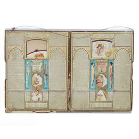
20C Bodyscope Educational Anatomy Pictorial FolioHill Auction Gallery 4.7(1k)See Sold PriceFeb 28, 2024
[ARCTIC]. BOWEN, Emanuel. A New & Accurate Map of the North...Potter & Potter Auctions4.6(545)See Sold PriceMar 07, 2024
[CIGARETTE CARDS]. JOHNSON, Jack (1878-1946). Four Rare Cig...Potter & Potter Auctions4.6(545)See Sold PriceMar 07, 2024
Arrowsmith & Lewis - Map of PolynesiaTrillium Antique Prints & Rare Books4.5(32)See Sold PriceFeb 24, 2024
Arrowsmith & Lewis - Map of North AmericaTrillium Antique Prints & Rare Books4.5(32)See Sold PriceFeb 24, 2024
Arrowsmith & Lewis - Map of the World on Mercator's ProjectionTrillium Antique Prints & Rare Books4.5(32)See Sold PriceFeb 24, 2024
Arrowsmith & Lewis - Map of LouisianaTrillium Antique Prints & Rare Books4.5(32)See Sold PriceFeb 24, 2024
Arrowsmith & Lewis - Map of the United StatesTrillium Antique Prints & Rare Books4.5(32)See Sold PriceFeb 24, 2024
1822 MAP of NORTH & SOUTH AMERICA GEOGRAPHICAL STATISTICAL HISTORICAL antiqueJasper524.5(9.9k)See Sold PriceFeb 27, 2024
Arnold Turtle (American/Illinois & New Orleans, 1892-1954), "Six Pen and Ink drawings of New OrleansCrescent City Auction Gallery4.3(231)See Sold PriceMar 08, 2024
ROYAL CROWN DERBY IMARI PORCELAINPridham's Auctions & Appraisals4.7(223)See Sold PriceMar 02, 2024
Herman Moll A New Map of Ye North Parts of AmericaWillow Auction House4.5(289)See Sold PriceMar 14, 2024
Hudson River Map & North American Postcards, 45Auctions at Showplace4.6(740)See Sold PriceFeb 13, 2025


![[ARCTIC]. BOWEN, Emanuel. A New & Accurate Map of the North... (1 of 1)](https://p1.liveauctioneers.com/928/318880/171360917_1_x.jpg?height=282&quality=70&version=1707501302)
![[CIGARETTE CARDS]. JOHNSON, Jack (1878-1946). Four Rare Cig... (1 of 2)](https://p1.liveauctioneers.com/928/318880/171361522_1_x.jpg?height=282&quality=70&version=1707501302)