ATLAS of ANTIENT GEOGRAPHY by SAMUEL BUTLER 1843John McInnis Auctioneers,LLC4.6(502)See Sold PriceFeb 24, 2024
18TH C. ANTIQUE MAP: FRENCH & INDIAN WAR, FRAMEDThomaston Place Auction Galleries4.4(386)See Sold PriceFeb 24, 2024
Rand McNally Railroad Map Cabinet w/ 21 Railroad MapsRail & Road Auctions4.6(165)See Sold PriceMar 08, 2024
Keith Haring - Ink on New York Map, Best Buddies, Inscribed, Signed, and DatedSapphire Auction Gallery4(67)See Sold PriceMar 02, 2024
LATE 17TH C. FRENCH MAP OF THE NEW WORLD BY ALEXIS-HUBERT JAILLOT (1632-1712)Thomaston Place Auction Galleries4.4(386)See Sold PriceFeb 24, 2024
Central Railroad of New Jersey Map of Sandy Hook Route-ca. 1903JM Hobby Supply and Railroad Artifact Auctions4.4(126)See Sold PriceFeb 24, 2024
Lot of Six Mixed Atlas Box Cars-HO Scale-New in BoxJM Hobby Supply and Railroad Artifact Auctions4.4(126)See Sold PriceFeb 25, 2024
Rand McNally/Santa Fe Railroad Map of Iowa-1912JM Hobby Supply and Railroad Artifact Auctions4.4(126)See Sold PriceFeb 24, 2024
NICOLAES VISSCHER (NETHERLANDS, 1618-1709) MAP OF THE NEW WORLDThomaston Place Auction Galleries4.4(386)See Sold PriceFeb 24, 2024
17TH C. WORLD MAP BY NICOLAES VISSCHER (NETHERLANDS, 1618-1709)Thomaston Place Auction Galleries4.4(386)See Sold PriceFeb 24, 2024
Lot of Six Mixed Atlas Cabooses-HO Scale-New in BoxJM Hobby Supply and Railroad Artifact Auctions4.4(126)See Sold PriceFeb 25, 2024
SoldThomson: Antique Map of St Kits, St Lucia, Nevis, 1816Map: West India Islands. St. Christophers. St. Lucia. Nevis Cartographer: John Thomson Place & Date: Edinburgh / 1816/1817 Size: 23 1/4" x 20" Condition: light overprinting; some browning and stainingSee Sold Price
Thomson: Antique Map St. Christophers, Nevis & St LuciaTitle/Content of Map: 'St Christophers. Nevis. St Lucia' A map of the British West Indian islands of St Kitts and Nevis, and St Lucia. Caribbean Date Printed: 1817 Image Size: Approx 53.5 x 65.5cm, 21See Sold Price
SoldThomson: Antique Map of West India Islands, 1817A map of the West India Islands including St. Christophers, Nevis and St. Lucia by Scottish cartographer John Thomson for his 1817 "New General Atlas." The map is printed on thick paper and was engravSee Sold Price
Thomson: Map of St Christophers, Nevis & St Lucia, 1817Title/Content of Map: 'St Christophers. Nevis. St Lucia' A map of the British West Indian islands of St Kitts and Nevis, and St Lucia This map is folding hence the centrefold line may show on the imagSee Sold Price
St Christophers, Nevis & St Lucia. St Kitts. West Indies. THOMSON 1830 old mapTITLE/CONTENT OF MAP: 'St Christophers // Nevis // St Lucia' A map of the British West Indian islands of St Kitts and Nevis, and St Lucia DATE PRINTED: 1830 IMAGE SIZE: Approx 52.5 x 64.0cm, 20.75 x 2See Sold Price
St Christophers, Nevis & St Lucia. St Kitts. West Indies. THOMSON 1817 old mapTITLE/CONTENT OF MAP: 'St Christophers. Nevis. St Lucia' A map of the British West Indian islands of St Kitts and Nevis, and St Lucia DATE PRINTED: Published in 1817 IMAGE SIZE: Approx 53.5 x 63.0cm,See Sold Price
SoldKirkwood & Son. West India IslandsKirkwood & Son. West India Islands, depicting the islands of St Christopher, St Lucia and Nevis from Thomson's New General Atlas, engraved map with outline hand-colouring, 540 x 640mm., 2 tearSee Sold Price
SoldKirkwood & Son. West India IslandsKirkwood & Son. West India Islands, depicting the islands of St Christopher, St Lucia and Nevis from Thomson's New General Atlas, engraved map with outline hand-colouring, 540 x 640mm., 2 tearSee Sold Price
SoldStock books and stamp album - British colonial andThree stock-books, containing a selection of postage stamps Victoria - Elizabeth II, inc: Leeward Islands, St Lucia & St Kits-Nevis, St Helena, St Vincent; Canada 1897 6c mint, 1928 Air - some with OtSee Sold Price
St Christophers, Nevis & St Lucia. St Kitts. WestTITLE/CONTENT OF MAP: 'St Christophers. Nevis. St Lucia' A map of the British West Indian islands of St Kitts and Nevis, and St Lucia DATE PRINTED: 1817 IMAGE SIZE: Approx 53.5 x 65.5cm, 21.25 x 25.75See Sold Price
St Christophers, Nevis & St Lucia. St Kitts. WestTITLE/CONTENT OF MAP: 'St Christophers. Nevis. St Lucia' A map of the British West Indian islands of St Kitts and Nevis, and St Lucia DATE PRINTED: 1817 IMAGE SIZE: Approx 53.5 x 65.5cm, 21.25 x 25.75See Sold Price
St Christophers, Nevis & St Lucia. St Kitts. WestTITLE/CONTENT OF MAP: 'St Christophers. Nevis. St Lucia' A map of the British West Indian islands of St Kitts and Nevis, and St Lucia DATE: 1817 IMAGE SIZE: Approx 53.5 x 65.5cm, 21.25 x 25.75 inchesSee Sold Price
Sold5 maps: West India Islands, Insulae Danicae...[Caribbean/Denmark/Central Europe] 5 Maps. Double-page. ++ West India Islands. 3 maps on 1 sheet: St. Christophers, St. Lucia, Nevis. “Engraved by Kirkwood & Son Edinburgh.” in margin. [C. 1810.]See Sold Price
SoldBellin: Antique Map of St. Lucia, 1764Carte de l'Isle de Sainte Lucie. Bellin's beautiful St. Lucie map, with rich topographical detail, many place names, and an elegant title cartouche, from his influential Petit Atlas Maritime. CartograSee Sold Price
SoldBellin: Antique Map of St. Lucia, 1750sMap: St. Lucia Date Printed: 1750's-60's Cartographer: Jacques Nicholas Bellin Material/Medium: Paper Size: 14 1/4" x 10" Condition: Excellent Copperplate engraving. Double page Map. Atlas De L'HistoiSee Sold Price
SoldBellin: Antique Map of St. Lucia, 1740Title/Content of Map: St. Lucia by Bellin Date Printed: c 1740-70's Cartographer: J.N. Bellin & J.F. La Harpe Material/Medium: Paper Size: 13 3/4" x 10" Copperplate engraved. Published in Paris. FromSee Sold Price
Thomson: Antique Map of St. Vincent & Barbados, 1814West India Islands. St. Vincent. Barbadoes. Two islands on one sheet, from Thomson's New General Atlas, both with dramatic topography and numerous place names. Cartographer: John Thomson Place & Date:See Sold Price
SoldThomson: Antique Map of U.S. / St. Lawrence River, 1817Map: The Course of the River St. Laurence/United States of America Cartographer: Thomson Place & Date: Edinburgh / 1817 Size: 24 1/4" x 16 1/8" Condition: overprinting and light age-toning throughout;See Sold Price
Weigel: Antique Map of Southern French Antilles, 1718Insulae Antillae Franciae Inferiores A dramatic German early 18th-century map of lower French Antilles, including St. Lucia, St. Vincent and the Grenadines, Grenada, and Barbados, based on "written coSee Sold Price
Thomson: Antique Map of River St. Laurence, 1817Title/Content of Map: 'The course of the River St. Laurence from Lake Ontario to Manicouagan Point' St Lawrence, Canada. Date Printed: 1817 Image Size: Approx 43.5 x 24.5cm, 17.25 x 9.75 inches (LargeSee Sold Price
Thomson: Antique Map of River St. Laurence, 1817TITLE/CONTENT OF MAP: 'The course of the River St. Laurence from Lake Ontario to Manicouagan Point' DATE PRINTED: 1817 IMAGE SIZE: Approx 43.5 x 24.5cm, 17.25 x 9.75 inches (Large) TYPE: Antique earlySee Sold Price
Thomson: Antique Map of River St. Laurence, 1817TITLE/CONTENT OF MAP: 'The course of the River St. Laurence from Lake Ontario to Manicouagan Point' DATE PRINTED: 1817 IMAGE SIZE: Approx 43.5 x 24.5cm, 17.25 x 9.75 inches (Large) TYPE: Antique earlySee Sold Price
Gothic Revival Stained Glass Window of St. SimonSchmidt's Antiques Inc. Since 19114.8(431)See Sold PriceMar 02, 2024
Vintage St Louis Crystal Ice Bucket and DecanterPasadena Antique Auctions4.3(6)See Sold PriceMar 10, 2024
Johann Homann Hand-Colored Map Engraving, c. 1730Auctions at Showplace4.5(726)See Sold PriceMar 17, 2024
17th CENTURY ST. FRANCIS HAND PAINTED SANTOLewis & Maese Antiques & Auction4.4(520)See Sold PriceFeb 25, 2024
Map of St. Kitts and Nevis Depot de la Marine, Paris, 1758Global Auctions Company4.3(36)See Sold PriceMar 03, 2024
D'Oyly (Calcutta, India) - Government House from St. Andrew's LibraryTrillium Antique Prints & Rare Books4.5(30)See Sold PriceFeb 24, 2024
Strickler, Rare - San Francisco, CaliforniaTrillium Antique Prints & Rare Books4.5(30)See Sold PriceFeb 24, 2024
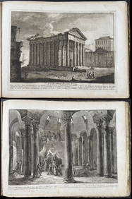
Morghen's Antichi Monumenti Esistenti - Volume with 44 EtchingsTrillium Antique Prints & Rare Books4.5(30)See Sold PriceFeb 24, 2024
Mivart & Keulemans - Mitchell's LoryTrillium Antique Prints & Rare Books4.5(30)See Sold PriceFeb 24, 2024
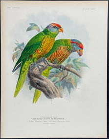
Mivart & Keulemans - Verreaux's LoryTrillium Antique Prints & Rare Books4.5(30)See Sold PriceFeb 24, 2024
Mivart & Keulemans - Tahiti Lory, Ultramarine LoryTrillium Antique Prints & Rare Books4.5(30)See Sold PriceFeb 24, 2024
Mivart & Keulemans - Black-capped Lory & Red-breasted LoryTrillium Antique Prints & Rare Books4.5(30)See Sold PriceFeb 24, 2024
1800 MUNGO PARK TRAVELS to AFRICA 2 VOLS w/ MAP antique in ENGLISHJasper524.5(9.8k)See Sold PriceFeb 27, 2024
1816 MAP SOUTHERN PART OF RUSSIA or MUSCOVY in EUROPE copper engraving ANTIQUEJasper524.5(9.8k)See Sold PriceFeb 27, 2024
1816 MAP NORTHERN PART OF RUSSIA or MUSCOVY in EUROPE copper engraving ANTIQUEJasper524.5(9.8k)See Sold PriceFeb 27, 2024
Vintage Stombecker Best Friend of Charleston Train Kit - Brand New Old Stock.Westside Traders Emporium4.5(34)See Sold PriceFeb 27, 2024
ANTIQUE RUSSIAN ORTHODOX ICON OF ST NICHOLAS 19TH CAntique Arena Inc.4.5(852)See Sold PriceMar 02, 2024
Geographical Statistical and Historical Map of the Windward IslandsJasper524.5(9.8k)See Sold PriceFeb 27, 2024
WEST AFRICA Explorers' routes Senegal Ashanti. Mountains of Kong. SDUK 1857 mapJasper524.5(9.8k)See Sold PriceFeb 28, 2024
Pre-colonial Africa. Mountains of Kong/Moon. Caravan routes. THOMSON 1817 mapJasper524.5(9.8k)See Sold PriceFeb 28, 2024
Theo. Hamm Brewing Co. St. Paul Birds Eye Factory MapMatthew Bullock Auctioneers4.7(1.8k)See Sold PriceMar 02, 2024