SoldKirkwood & Son. West India IslandsKirkwood & Son. West India Islands, depicting the islands of St Christopher, St Lucia and Nevis from Thomson's New General Atlas, engraved map with outline hand-colouring, 540 x 640mm., 2 tearSee Sold Price
SoldKirkwood & Son. West India IslandsKirkwood & Son. West India Islands, depicting the islands of St Christopher, St Lucia and Nevis from Thomson's New General Atlas, engraved map with outline hand-colouring, 540 x 640mm., 2 tearSee Sold Price
Sold5 maps: West India Islands, Insulae Danicae...[Caribbean/Denmark/Central Europe] 5 Maps. Double-page. ++ West India Islands. 3 maps on 1 sheet: St. Christophers, St. Lucia, Nevis. “Engraved by Kirkwood & Son Edinburgh.” in margin. [C. 1810.]See Sold Price
[WEST INDIES]. West India Islands. Double-pag[WEST INDIES]. West India Islands. Double-page engraved map by Kirkwood & Sons, Edin., c.1821. 19 3/4 x 20 1/2, outline color. Very good condition. Features Dominica and Martinico, with inset map of CSee Sold Price
West India Islands, and Central America.Title: West India Islands, and Central America. Printing Date: 1860 Cartographer: LOWRY, J. W. Publisher: BLACKIE & SON Size: 13.5Height - 19.75Width Additional Information: Inset of Jamaica. Chart beSee Sold Price
West Indies Islands. St. VincentTitle/Content of Map: West Indies Islands. St. Vincent Date Printed: 1817 Cartographer: THOMSON, JOHN & CO. Size: 19.6X11.3 Part of No.52 from Thomson's New General Atlas 1817. Kirkwood & Son sculpt.See Sold Price
West Indies Islands. Martinico | Dominica.Title/Content of Map: West Indies Islands. Martinico | Dominica. Date Printed: 1817 Cartographer: THOMSON, JOHN & CO. Size: 19.3X23 No.51 from Thomson's New General Atlas 1817. Kirkwood & Son sculpt.See Sold Price
SoldTallis: Map of the Caribbean & West India Islands, 18511851 Tallis Map of the Caribbean -- West India Islands. This is an ornate and highly decorative map of the Caribbean from the Bahamas to Columbia and Venezuela. The map features three vignettes and faSee Sold Price
SoldWest India Islands Map, 1842West India Islands. Harper, Morse & Breese. 1842 ca. Map detailing topography, towns, ports, bays, points, banks, etc. With table re: square miles & population of islands. Please note that this lot haSee Sold Price
SoldTallis, John (Pub) 1852 Map. West India IslandsSteel Engraved Map with Original Outline Hand Color Published 1852-56 by John Tallis, London for "The Universal Pronouncing Dictionary" by Thomas Wright. Drawn & Engraved by John Rapkin. Centre fold aSee Sold Price
1851 Tallis Map of the Caribbean, West India Islands1851 Tallis Map of the Caribbean -- West India Islands. J. Tallis. 1851 London. 10 x 13 in. This is an ornate and highly decorative map of the Caribbean from the Bahamas to Columbia and Venezuela. TheSee Sold Price
SoldWest India IslandsTitle/Content of Map: West India Islands Date: c1925 Cartographer: Publisher: Rubsamen, Wilh. C. Size: 42Height - 50Width Important German map exhibiting strategic importance of the Panama Canal, whicSee Sold Price
Malham: Antique Map of the West India Islands, 1797Title/Content of Map: A Correct Chart of the West India Islands engraved for Malham's Naval Gazetteer Date Printed: 1797 Cartographer: Malham, John Size (inches): 9 x 7 Antique nautical chart showingSee Sold Price
SoldThomson: Antique Map of West India Islands, 1817A map of the West India Islands including St. Christophers, Nevis and St. Lucia by Scottish cartographer John Thomson for his 1817 "New General Atlas." The map is printed on thick paper and was engravSee Sold Price
SoldAntilles, Or West India IslandsTitle/Content of Map: Antilles, Or West India Islands Date Printed: 1893 ca. Cartographer: FISK & CO. Size: 9.25X12.25 Montreal plan on reverse. From The Columbian Atlas of the world we live in. MargiSee Sold Price
SoldWEST INDIA ISLANDS. Caribbean Indies Antilles Bahamas.TITLE/CONTENT OF MAP: 'West India Islands' Show the West Indies, Antilles, Windward Islands, Leeward Islands, Cuba, the Bahamas, Hispaniola, Turks & Caicos Islands. Vignettes: Kingston, Jamaica, fromSee Sold Price
WEST INDIA ISLANDS. Caribbean Indies Antilles Bahamas.Reserve Reduced! TITLE/CONTENT OF MAP: 'West India Islands' Show the West Indies, Antilles, Windward Islands, Leeward Islands, Cuba, the Bahamas, Hispaniola, Turks & Caicos Islands. Vignettes: KingstoSee Sold Price
1817 Map of West India IslandsTitle: 1817 Map of West India Islands Author: Thompson Medium: Ink on paper Dimensions: 28.5"X21.5" Description: Map of the West India Islands dated 1817. It captures St. Christopher, St. Lucia and NeSee Sold Price
West India Islands. Caribbean. La Salle settlement inTITLE/CONTENT OF MAP: 'West India Islands and adjacent coasts of the United States, Mexico, Guatimala & Colombia' The map notes anecdotally the location of René Robert Cavelier, Sieur de La Salle, esSee Sold Price
Sold19thc Map: West India Islands, John Tallis & CoFramed 19th century antique map. West India Islands, John Tallis & Company, London and New York, Published 1851. Hand colored, the map drawn and engraved by J. Rapkin. The illustrations by H. Warren &See Sold Price
WEST INDIA ISLANDS. Caribbean Indies Antilles Bahamas.Reserve Reduced! TITLE/CONTENT OF MAP: 'West India Islands' Show the West Indies, Antilles, Windward Islands, Leeward Islands, Cuba, the Bahamas, Hispaniola, Turks & Caicos Islands. Vignettes: KingstoSee Sold Price
1817 Map of the West India IslandsTitle: 1817 Map of the West India Islands Author: Thompson Medium: Ink on Paper Dimensions: 28.5"X21.5" Description: Map of the West India Islands dated 1817. It captures St. Christopher, St. Lucia anSee Sold Price
The Antilles, West India Islands MapThe Antilles, Or West India Islands. Hunt & Eaton, Fisk & Co. Hunt & Eaton. 1893 ca. Montreal plan on reverse. From The Columbian Atlas of the world we live in. Quarto – 9.25 H x 12.25 W Inches PleaSee Sold Price
SoldWEST INDIA ISLANDS MAPWEST INDIA ISLANDS MAP BY A.K. JOHNSTON F.R.G.S.INCLUDES FLORIDA26 X 22 FOLD CREASE IN MIDDLE 18th CENTURYSee Sold Price
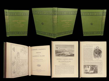
1874 HAWAII 1ed Northern California Oregon Pacific Island Travel Puget RedwoodsSchilb Antiquarian Rare Books4.8(421)See Sold PriceMar 10, 2024
Nostalgia #383 3rd West India Regiment of 1863Old Toy Soldier Auctions USA4.8(1.1k)See Sold PriceMar 15, 2024
SONS OF THE WEST BIOGRAPHICAL ACCOUNT OF EARLY DAY WYOMING Signed 1941North American Artifact Auctions4.6(182)See Sold PriceApr 20, 2024
Mid Century & Vintage Postcards Germany, Paris +The Benefit Shop Foundation Inc.4.3(2.9k)See Sold PriceMar 13, 2024
West Indies Islands. Guadaloupe. | Mariegalante &C. | Antigua.Jasper524.5(9.8k)See Sold PriceFeb 27, 2024
New and Correct Map of North America With the West India Islands,Jasper524.5(9.8k)See Sold PriceFeb 27, 2024
1834 Malte-Brun Map of the Caribbean -- West India IslandsJasper524.5(9.8k)See Sold PriceFeb 27, 2024
Blackie (Pub) 1882 Folio Map. West India Islands & Central AmericaAlbion Auctions4.6(336)See Sold PriceMar 01, 2024
Early Figural bar tender themed beer bottleBaker's Antiques and Auctions3.3(462)See Sold PriceFeb 27, 2024


![[WEST INDIES]. West India Islands. Double-pag (1 of 0)](https://p1.liveauctioneers.com/dist/images/placeholder.jpg?height=282&quality=70)