ATLAS of ANTIENT GEOGRAPHY by SAMUEL BUTLER 1843John McInnis Auctioneers,LLC4.5(505)See Sold PriceFeb 24, 2024
18TH C. ANTIQUE MAP: FRENCH & INDIAN WAR, FRAMEDThomaston Place Auction Galleries4.4(393)See Sold PriceFeb 24, 2024
Rand McNally Railroad Map Cabinet w/ 21 Railroad MapsRail & Road Auctions4.6(165)See Sold PriceMar 08, 2024
Keith Haring - Ink on New York Map, Best Buddies, Inscribed, Signed, and DatedSapphire Auction Gallery4(67)See Sold PriceMar 02, 2024
LATE 17TH C. FRENCH MAP OF THE NEW WORLD BY ALEXIS-HUBERT JAILLOT (1632-1712)Thomaston Place Auction Galleries4.4(393)See Sold PriceFeb 24, 2024
Central Railroad of New Jersey Map of Sandy Hook Route-ca. 1903JM Hobby Supply and Railroad Artifact Auctions4.4(127)See Sold PriceFeb 24, 2024
Lot of Six Mixed Atlas Box Cars-HO Scale-New in BoxJM Hobby Supply and Railroad Artifact Auctions4.4(127)See Sold PriceFeb 25, 2024
Rand McNally/Santa Fe Railroad Map of Iowa-1912JM Hobby Supply and Railroad Artifact Auctions4.4(127)See Sold PriceFeb 24, 2024
NICOLAES VISSCHER (NETHERLANDS, 1618-1709) MAP OF THE NEW WORLDThomaston Place Auction Galleries4.4(393)See Sold PriceFeb 24, 2024
17TH C. WORLD MAP BY NICOLAES VISSCHER (NETHERLANDS, 1618-1709)Thomaston Place Auction Galleries4.4(393)See Sold PriceFeb 24, 2024
Lot of Six Mixed Atlas Cabooses-HO Scale-New in BoxJM Hobby Supply and Railroad Artifact Auctions4.4(127)See Sold PriceFeb 25, 2024
SoldThe Scots Magazine Containing Maps of the Battle of theThe Scots Magazine. Edinburgh, Scotland: October, 1759. Vol. XXI. 55pp, (pages include 505-560), 5 x 8.25 in. This issue contains two 5 x 8.25 in. blank back maps of the Battle of the Plains of AbrahaSee Sold Price
SCOTS MAGAZINESCOTS MAGAZINE The Scots magazine containing a general view of the religion, politics, entertainment in Great Britain and a succinct account of publick affairs foreign and domestic for the year 1739 VSee Sold Price
Sold1775 Battle of Bunker’s Hill Battle Maps PrintsAmerican Revolution 1775 Battle of Bunker’s Hill Battle Maps Prints & Magazine September 1775-Dated Revolutionary War, Issue of The Gentleman’s Magazine and c. 1856 Print of a Bunker’s Hill BattSee Sold Price
SoldMap of Boston and Vicinity 1775Title: Thirty-Miles round Boston, by M. Armstrong Geo. 14th Augt. 1775 Author: Scots Magazine Description: Copper-engraved map. 25.5x25.5 cm. (10x10"), matted. The Boston region as the rebels were begSee Sold Price
SoldBritish & French Settlements in N. Am. 1755Title: A Map of the British and French Settlements in North America Author: Scots Magazine Description: Copper-engraved map, with folds. Engraved by T. Phinn. 28x38 cm. (11x15").With text outlining thSee Sold Price
SoldMap of Maryland 1781Title: A Map of Maryland with Part of Virginia and Pensylvania Author: Scots Magazine Description: Copper-engraved map. 16.5x16.5 cm. (6½x6½").Key soon-to-be-former colonies at the end of the AmericSee Sold Price
SoldMap of the Country round Philadelphia 1776Title: A Map of the Country round Philadelphia Including Part of New Jersey New York Staten Island & Long Island Author: Scots Magazine Description: Copper-engraved map. 17.5x21.7 cm. (6¾x8½").JollySee Sold Price
SoldBritish & French Settlements in N. Am. 1750Title: A Map of the British and French Settlements in North America Author: Scots Magazine Description: Copper-engraved map, with folds. Engraved by T. Phinn. 28x38 cm. (11x15").With text outlining thSee Sold Price
SoldSoldier's letter discussing the Battle of Chancellorsville and containing hand-drawn map showingSoldier's letter discussing the Battle of Chancellorsville and containing hand-drawn map showing rebel positions and 2 Confederate envelopes, by Charles D. Gilmore as a major of the 20th Maine InfantrSee Sold Price
Scots Magazine (1759)Sand, Donaldson, Murray & Cochran Edinburgh 1sr Edition Full year including appendix 707 pages plus index. Volume 21 9 maps, plans & engravings some foldout .Numerous articles on America including FreSee Sold Price
Scots Magazine (1758)Sand, Donaldson, Murray & Cochran Edinburgh 1sr Edition Full year including appendix 708 pages plus index. Volume 20 6 maps, plans & engravings. Lacking maps of Europe & Scotland. & pages 181-196.. .NSee Sold Price
Scots Magazine (1757)Sand, Donaldson, Murray & Cochran Edinburgh 1sr Edition Full year including appendix 705 pages plus index. Volume 19. Fold out maps of Germany & Chart Of The Sea Scoat betewen england & Germany etc..NSee Sold Price
Sold1806 Scots Magazine And Edinburgh Literary Miscellany1st Edition July through Dec Volume68. Pages 494-986. 6 plates & maps. Numerous articles on America inluding Bonaparte extorts 2 million dollars from congress. and much on Napoleon. July through Dec VSee Sold Price
1807 Scots Magazine And Edinburgh Literary Miscellany1st Edition Jan through June Volume 69. Pages 480 pages. 65 plates & maps. Jan through June Volume 69. Pages 480 pages. 65 plates & maps. Archbald Constable 1/2 Leather 8voSee Sold Price
1740 Accurate Map of West Indies Saint Augustine View1740 Volume of Gentleman's Magazine containing all twelve issues including Supplement. Features much on West Indies including: large folding map "An Accurate Map of the West Indies..", "A View of theSee Sold Price
1741 Scots MagazineFull year Jan- December including Appendix. Volume 3 608 pages plus index. fold out map of Cartagena.1st edition EdinburghSee Sold Price
1772 Scots Magazine1st Edition Complete year including appendix for 1772.728 pages plus index.Volume 34. with fold out map of Poland & plan of dutch shack. . Naturally has much America including lead up to the revolutioSee Sold Price
Scots Magazine (1775)A. Murray and J. Cochran Edinburgh 1sr Edition Complete year including appendix for 1775.735 pages plus index.Volume 37. with fold out map "30 miles around Boston". Naturally has much America includinSee Sold Price
Scots Magazine (1772)A. Murray and J. Cochran Edinburgh 1sr Edition Complete year including appendix for 1772.728 pages plus index.Volume 34. with fold out map of Poland & plan of dutch shack. . Naturally has much AmericaSee Sold Price
1770 Scots Magazine1st Edition Complete year including appendix for 1770.729 pages plus index.Volume 32. with fold out map. Naturally has much America including climate change and America discovered by the Welch and mucSee Sold Price
Scots Magazine (1770)A. Murray and J. Cochran Edinburgh 1sr Edition Complete year including appendix for 1770.729 pages plus index.Volume 32. with fold out map. Naturally has much America including climate change and discSee Sold Price
SoldANTIQUE EMBOSSED LEATHER FAMILY DEVOTIONAL BIBLEBook: The Family Devotional Bible, 19thc., London Printing and Publishing, The Rev. Matthew Henry, having gilt embossed leather binding, marbleized interior cover, containing maps, images and personalSee Sold Price
The Later Stuarts 1660-1714The Oxford History of England' Dust-jacket with title and vignette. Publishers navy cloth with gilt title and vignette to spine. Colour top page block. 9 fold-outs containing maps. 2 fold-out genealogSee Sold Price
ca.1930s GRAPHIC VINTAGE TRAVEL BROCHURE for SKOWHEGAN,ca.1930s GRAPHIC VINTAGE TRAVEL BROCHURE for SKOWHEGAN, MAINE ME On The Kennebec Description: Circa 1930s Graphic Old Vintage Travel Brochure; Skowhegan, Maine - On the Kennebec - containing map, prinSee Sold Price
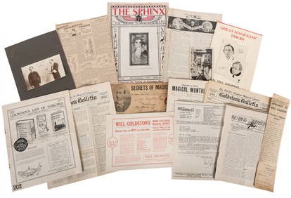
GOLDSTON, Will (1878 – 1948). Archive of Will Goldston Phot...Potter & Potter Auctions4.6(545)See Sold PriceFeb 24, 2024
Large lot of assorted prints. 18th-20th century. To include: North American and other maps, CivilTremont Auctions4.5(297)See Sold PriceFeb 25, 2024
1888 Hand Book of the Pennsylvania Lines Containing Maps of Principal Cities - First EditionRail & Road Auctions4.6(165)See Sold PriceMar 07, 2024
1849 THE NEW-ENGLAND MERCANTILE UNIONNorth American Artifact Auctions4.7(198)See Sold PriceApr 20, 2024
HAMMOND'S READY REFERENCE HISTORICAL ATLAS 1920North American Artifact Auctions4.7(198)See Sold PriceApr 20, 2024
1905 20th Century Atlas of Boone County IllinoisMatthew Bullock Auctioneers4.7(1.8k)See Sold PriceFeb 24, 2024
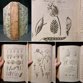
1797 Universal Magazine BOTANY PLATES Flowers FRUIT 12 Copper Engraved PlatesPrivate NY Collection4.2(22)See Sold PriceMar 01, 2024
Mitchell - Map of the City of Washington (Washington, DC)Trillium Antique Prints & Rare Books4.5(32)See Sold PriceFeb 24, 2024
1816 MAP SOUTHERN PART OF RUSSIA or MUSCOVY in EUROPE copper engraving ANTIQUEJasper524.5(9.9k)See Sold PriceFeb 27, 2024
1816 MAP NORTHERN PART OF RUSSIA or MUSCOVY in EUROPE copper engraving ANTIQUEJasper524.5(9.9k)See Sold PriceFeb 27, 2024
First World War.- Petre (F.Loraine), Wilfrid Ewart & Major General Lowther. The Scots Guards in theForum Auctions4.3(53)See Sold PriceFeb 29, 2024
Carte de la Guinée, contenant…'. Guinea & Cape Verde islands. BONNE 1771 mapJasper524.5(9.9k)See Sold PriceFeb 28, 2024
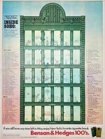
Map Inside Soho - Manhattan - New York Magazine 1974Proverde Auctions4.3(3)See Sold PriceFeb 28, 2024