ATLAS of ANTIENT GEOGRAPHY by SAMUEL BUTLER 1843John McInnis Auctioneers,LLC4.5(505)See Sold PriceFeb 24, 2024
18TH C. ANTIQUE MAP: FRENCH & INDIAN WAR, FRAMEDThomaston Place Auction Galleries4.4(393)See Sold PriceFeb 24, 2024
Rand McNally Railroad Map Cabinet w/ 21 Railroad MapsRail & Road Auctions4.6(165)See Sold PriceMar 08, 2024
Keith Haring - Ink on New York Map, Best Buddies, Inscribed, Signed, and DatedSapphire Auction Gallery4(67)See Sold PriceMar 02, 2024
LATE 17TH C. FRENCH MAP OF THE NEW WORLD BY ALEXIS-HUBERT JAILLOT (1632-1712)Thomaston Place Auction Galleries4.4(393)See Sold PriceFeb 24, 2024
Central Railroad of New Jersey Map of Sandy Hook Route-ca. 1903JM Hobby Supply and Railroad Artifact Auctions4.4(127)See Sold PriceFeb 24, 2024
Lot of Six Mixed Atlas Box Cars-HO Scale-New in BoxJM Hobby Supply and Railroad Artifact Auctions4.4(127)See Sold PriceFeb 25, 2024
Rand McNally/Santa Fe Railroad Map of Iowa-1912JM Hobby Supply and Railroad Artifact Auctions4.4(127)See Sold PriceFeb 24, 2024
NICOLAES VISSCHER (NETHERLANDS, 1618-1709) MAP OF THE NEW WORLDThomaston Place Auction Galleries4.4(393)See Sold PriceFeb 24, 2024
17TH C. WORLD MAP BY NICOLAES VISSCHER (NETHERLANDS, 1618-1709)Thomaston Place Auction Galleries4.4(393)See Sold PriceFeb 24, 2024
Lot of Six Mixed Atlas Cabooses-HO Scale-New in BoxJM Hobby Supply and Railroad Artifact Auctions4.4(127)See Sold PriceFeb 25, 2024
SoldTEXAS C. 1886 MAP, PART OF INDIAN TERRITORYFramed map of Texas, c. 1886, showing counties with an inset for the Panhandle and a portion of the Indian Territory (Cheyennes, Arrapahoes), sight: 11.75"h, 17"w, overall: 21.75"h, 25.75"w, 4.25lbs SSee Sold Price
SoldH C Tunison TUNISON′S PEERLESS UNIVERSALH C Tunison TUNISON′S PEERLESS UNIVERSAL ATLAS OF THE WORLD 1886 Folio Decorative Gilt Hand‐Colored Maps Engraved Diagrams Vignettes Indian Territory Texas Presidential Portraits SSee Sold Price
Sold1886 Cram Map of Texas [verso] Indian Territory [and]Reserve Reduced! Title/Content of Map: 1886 Cram Map of Texas [verso] Indian Territory [and] Arkansas -- Texas [verso] Indian Ty. [and] Arkansas Date: 1886, Chicago Cartographer: G Cram Size: 11.8 x 1See Sold Price
Sold1886 Cram Map of Texas [verso] Indian Territory [verso]Title/Content of Map: 1886 Cram Map of Texas [verso] Indian Territory [verso] Arkansas -- Texas [verso] Indian Ty. [verso] Arkansas Date: 1882, Chicago Cartographer: G CramSize: 12 X 17 in. This is aSee Sold Price
Sold1886 Cram Map of Texas [verso] Indian Territory [verso]Title/Content of Map: 1886 Cram Map of Texas [verso] Indian Territory [verso] Arkansas -- Texas [verso] Indian Ty. [verso] Arkansas Cartographer: G Cram /People's Publishing Co. Year/Place: 1886, ChicSee Sold Price
1886 Cram Map of Texas [verso] Indian Territory [and]Title/Content of Map: 1886 Cram Map of Texas [verso] Indian Territory [and] Arkansas -- Texas [verso] Indian Ty. [and] Arkansas Date: 1886, Chicago Cartographer: G Cram Size: 11.8 x 17 in. A very detaSee Sold Price
Sold1886 Cram Map of Texas [verso] Indian Territory [verso]Title/Content of Map: 1886 Cram Map of Texas [verso] Indian Territory [verso] Arkansas -- Texas [verso] Indian Ty. [verso] Arkansas Date: 1886, Chicago Cartographer: G Cram Size: 12 X 17 in. This is aSee Sold Price
Sold1886 Cram Map of Texas [verso] Indian Territory [verso]Title/Content of Map: 1886 Cram Map of Texas [verso] Indian Territory [verso] Arkansas -- Texas [verso] Indian Ty. [verso] Arkansas Date: 1882, Chicago Cartographer: G Cram Size: 12 X 17 in. This is aSee Sold Price
1886 Cram Map of Texas [verso] Indian Territory [verso]Title/Content of Map: 1886 Cram Map of Texas [verso] Indian Territory [verso] Arkansas -- Texas [verso] Indian Ty. [verso] Arkansas Cartographer: G Cram /People's Publishing Co. Year/Place: 1886, ChicSee Sold Price
1886 Cram Map of Texas [verso] Indian Territory [and]Title/Content of Map: 1886 Cram Map of Texas [verso] Indian Territory [and] Arkansas -- Texas [verso] Indian Ty. [and] Arkansas Date Printed: 1886, Chicago Cartographer: G Cram Size: 11.8 x 17 in. A vSee Sold Price
1886 Cram Map of Texas [verso] Indian TerritoryTitle/Content of Map: 1886 Cram Map of Texas [verso] Indian Territory [and] Arkansas -- Texas [verso] Indian Ty. [and] Arkansas1886, Chicago Cartographer: G Cram Size: 11.8 x 17 in. A very detailed maSee Sold Price
1886 Cram Map of Texas [verso] Indian Territory [verso]Title/Content of Map: 1886 Cram Map of Texas [verso] Indian Territory [verso] Arkansas -- Texas [verso] Indian Ty. [verso] Arkansas Date: 1886, Chicago Cartographer: G Cram Size: 12 X 17 in. This is aSee Sold Price
1886 Cram Map of Texas [verso] Indian Territory [verso]Title/Content of Map: 1886 Cram Map of Texas [verso] Indian Territory [verso] Arkansas -- Texas [verso] Indian Ty. [verso] Arkansas Cartographer: G Cram Size: 12 X 17 in. This is a very nice double paSee Sold Price
SoldTUNISON'S MAP OF TEXAS & INDIAN TERRITORY, C. 1890Unframed Tunison's Map of Texas and Indian Territory, c. 1890, bright colors, verso with maps of Nebraska and Alabama, overall including margin: 21.7/8"h, 14"w Start Price: $80.00See Sold Price
Cram: Antique Map of Texas & Indian Territory, 1886Title/Content of Map: 1886 Cram Map of Texas / Arkansas and Indian Territory on Verso -- Texas; Arkansas; Indian Ty. Date Printed: 1886, Chicago Cartographer: G Cram Size: 11.8 x 17 in. Handsomely detSee Sold Price
SoldCram: Antique Map of Texas, 1886Title/Content of Map: 1886 Cram Map of Texas / Arkansas and Indian Territory on Verso -- Texas; Arkansas; Indian Ty. Date Printed: 1886, Chicago Cartographer: G Cram Size: 11.8 x 17 in. Handsomely detSee Sold Price
Whipple: Antique Map of Arkansas & Indian TerritoryTitle/Content of Map: 1853-4 Whipple Map of Parts of Arkansas, Indian Territory, Texas and New Mexico -- Map No. 1 From Fort Smith to the Rio Grande…under the direction of the Hon. Jefferson Davis,See Sold Price
Whipple: Antique Map of Arkansas, Indian Territory 1853Title/Content of Map: 1853-4 Whipple Map of Parts of Arkansas, Indian Territory, Texas and New Mexico -- Map No. 1 From Fort Smith to the Rio Grande…under the direction of the Hon. Jefferson DavSee Sold Price
Whipple: Antique Map Arkansas, Indian Territory, 1853-4Title/Content of Map: 1853-4 Whipple Map of Parts of Arkansas, Indian Territory, Texas and New Mexico -- Map No. 1 From Fort Smith to the Rio Grande…under the direction of the Hon. Jefferson Davis,See Sold Price
1853-4 Whipple Map of Parts of Arkansas, IndianTitle/Content of Map: 1853-4 Whipple Map of Parts of Arkansas, Indian Territory, Texas and New Mexico -- Map No. 1 From Fort Smith to the Rio Grande…under the direction of the Hon. Jefferson Davis,See Sold Price
1853-4 Whipple Map of Parts of Arkansas, IndianTitle/Content of Map: 1853-4 Whipple Map of Parts of Arkansas, Indian Territory, Texas and New Mexico -- Map No. 1 From Fort Smith to the Rio Grande…under the direction of the Hon. Jefferson Davis,See Sold Price
1853-4 Whipple Map of Parts of Arkansas, IndianTitle/Content of Map: 1853-4 Whipple Map of Parts of Arkansas, Indian Territory, Texas and New Mexico -- Map No. 1 From Fort Smith to the Rio Grande…under the direction of the Hon. Jefferson Davis,See Sold Price
1853-4 Whipple Map of Parts of Arkansas, IndianTitle/Content of Map: 1853-4 Whipple Map of Parts of Arkansas, Indian Territory, Texas and New Mexico -- Map No. 1 From Fort Smith to the Rio Grande…under the direction of the Hon. Jefferson Davis,See Sold Price
1853-4 Whipple Map of Arkansas, Indian TerritoryTitle/Content of Map: 1853-4 Whipple Map of Parts of Arkansas, Indian Territory, Texas and New Mexico -- Map No. 1 From Fort Smith to the Rio Grande…under the direction of the Hon. Jefferson Davis,See Sold Price
18TH C. ANTIQUE MAP: FRENCH & INDIAN WAR, FRAMEDThomaston Place Auction Galleries4.4(393)See Sold PriceFeb 24, 2024
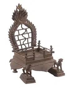
INDIAN HINDU BRONZE ALTAR VOTIVE STANDThomaston Place Auction Galleries4.4(393)See Sold PriceFeb 24, 2024
William Merritt Chase (American, 1849-1916) - Tony with a Red CapFreeman's | Hindman4.5(158)See Sold PriceFeb 28, 2024
1816 MAP SOUTHERN PART OF RUSSIA or MUSCOVY in EUROPE copper engraving ANTIQUEJasper524.5(9.9k)See Sold PriceFeb 27, 2024
1816 MAP NORTHERN PART OF RUSSIA or MUSCOVY in EUROPE copper engraving ANTIQUEJasper524.5(9.9k)See Sold PriceFeb 27, 2024
1749 MAP CARTE DE LA TARTARIE ORIENTALE RUSSIA & CHINA antique EASTERN TARTARYJasper524.5(9.9k)See Sold PriceFeb 27, 2024
Hist. of Indian wars of the Far West - Massacres of the MountainsJasper524.5(9.9k)See Sold PriceFeb 27, 2024
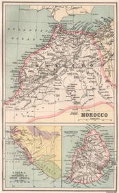
Northwest Africa. Morocco Sahara Rio do Oro Ain Sefra Gardaia. STANFORD 1904 mapJasper524.5(9.9k)See Sold PriceFeb 28, 2024
MOROCCO LIBERIA & MAURITIUS. Sierra Leone. BARTHOLOMEW 1886 old antique mapJasper524.5(9.9k)See Sold PriceFeb 28, 2024
Bougainville's 1766 circumnavigation. France-Africa-Réunion. GENTS MAG 1774 mapJasper524.5(9.9k)See Sold PriceFeb 28, 2024
NILE VALLEY. Upper & Lower. Egypt Sinai Nubia Sudan Abyssinia. BLACKIE 1886 mapJasper524.5(9.9k)See Sold PriceFeb 28, 2024
Robert H Labberton - Map of The Territory of the Present United States - The territory of theProverde Auctions4.3(3)See Sold PriceFeb 28, 2024


![1886 Cram Map of Texas [verso] Indian Territory [and] (1 of 3)](https://p1.liveauctioneers.com/5584/128997/65616692_1_x.jpg?height=282&quality=70&version=1539125359)
![1886 Cram Map of Texas [verso] Indian Territory [verso] (1 of 3)](https://p1.liveauctioneers.com/5584/137769/69881200_1_x.jpg?height=282&quality=70&version=1552435690)
![1886 Cram Map of Texas [verso] Indian Territory [verso] (1 of 3)](https://p1.liveauctioneers.com/5584/175972/88577718_1_x.jpg?height=282&quality=70&version=1597183226)
![1886 Cram Map of Texas [verso] Indian Territory [and] (1 of 3)](https://p1.liveauctioneers.com/5584/124256/63192808_1_x.jpg?height=282&quality=70&version=1530636078)
![1886 Cram Map of Texas [verso] Indian Territory [verso] (1 of 3)](https://p1.liveauctioneers.com/5584/161241/81395745_1_x.jpg?height=282&quality=70&version=1581460166)
![1886 Cram Map of Texas [verso] Indian Territory [verso] (1 of 3)](https://p1.liveauctioneers.com/5584/144578/73088219_1_x.jpg?height=282&quality=70&version=1561513819)
![1886 Cram Map of Texas [verso] Indian Territory [verso] (1 of 3)](https://p1.liveauctioneers.com/5584/167533/84481014_1_x.jpg?height=282&quality=70&version=1588715327)
![1886 Cram Map of Texas [verso] Indian Territory [and] (1 of 3)](https://p1.liveauctioneers.com/5584/120531/61366377_1_x.jpg?height=282&quality=70&version=1524014838)
![1886 Cram Map of Texas [verso] Indian Territory (1 of 3)](https://p1.liveauctioneers.com/5584/118678/60730603_1_x.jpg?height=282&quality=70&version=1521593100)
![1886 Cram Map of Texas [verso] Indian Territory [verso] (1 of 3)](https://p1.liveauctioneers.com/5584/155577/78518648_1_x.jpg?height=282&quality=70&version=1574821323)
![1886 Cram Map of Texas [verso] Indian Territory [verso] (1 of 3)](https://p1.liveauctioneers.com/5584/141761/71765307_1_x.jpg?height=282&quality=70&version=1557879901)