ATLAS of ANTIENT GEOGRAPHY by SAMUEL BUTLER 1843John McInnis Auctioneers,LLC4.5(505)See Sold PriceFeb 24, 2024
18TH C. ANTIQUE MAP: FRENCH & INDIAN WAR, FRAMEDThomaston Place Auction Galleries4.4(393)See Sold PriceFeb 24, 2024
Rand McNally Railroad Map Cabinet w/ 21 Railroad MapsRail & Road Auctions4.6(165)See Sold PriceMar 08, 2024
Keith Haring - Ink on New York Map, Best Buddies, Inscribed, Signed, and DatedSapphire Auction Gallery4(67)See Sold PriceMar 02, 2024
LATE 17TH C. FRENCH MAP OF THE NEW WORLD BY ALEXIS-HUBERT JAILLOT (1632-1712)Thomaston Place Auction Galleries4.4(393)See Sold PriceFeb 24, 2024
Central Railroad of New Jersey Map of Sandy Hook Route-ca. 1903JM Hobby Supply and Railroad Artifact Auctions4.4(127)See Sold PriceFeb 24, 2024
Lot of Six Mixed Atlas Box Cars-HO Scale-New in BoxJM Hobby Supply and Railroad Artifact Auctions4.4(127)See Sold PriceFeb 25, 2024
Rand McNally/Santa Fe Railroad Map of Iowa-1912JM Hobby Supply and Railroad Artifact Auctions4.4(127)See Sold PriceFeb 24, 2024
NICOLAES VISSCHER (NETHERLANDS, 1618-1709) MAP OF THE NEW WORLDThomaston Place Auction Galleries4.4(393)See Sold PriceFeb 24, 2024
17TH C. WORLD MAP BY NICOLAES VISSCHER (NETHERLANDS, 1618-1709)Thomaston Place Auction Galleries4.4(393)See Sold PriceFeb 24, 2024
Lot of Six Mixed Atlas Cabooses-HO Scale-New in BoxJM Hobby Supply and Railroad Artifact Auctions4.4(127)See Sold PriceFeb 25, 2024
SoldStrait of Magellan Map, Theodore De Bry, 1601[Strait of Magellan Map], "Fretum Magellannicum", by Theodore De Bry, Frankfurt, 1601, copper engraved, depicting ships, natives, a penguin and a snail, 6 1/2 in. x 11 3/4 in., framedSee Sold Price
SoldStrait of Magellan Map[Strait of Magellan Map] , "Fretum Magellannicum", by Theodore De Bry, Frankfurt, 1601, copper engraved, depicting ships, natives, a penguin and a snail, 6 1/2 in. x 11 3/4 in., framed IMPORTANT: AllSee Sold Price
SoldTheodore De Bry, Strait of Magellan Map, "FretumTheodore De Bry, Strait of Magellan Map, "Fretum Magellannicum...", c. 1602, copper-plate engraved map from De Bry's Grand Voyages, showing compass rose, various peoples, a penguin and a giant snail,See Sold Price
[Strait of Magellan Map][Strait of Magellan Map], "Fretum Magellannicum...", c. 1602, copper-plate engraved map from De Bry's Grand Voyages, showing compass rose, various peoples, a penguin and a giant snail, sight 7 in. x 1See Sold Price
(Hariot's Virginia) Wunderbarlichedoch Warhafftige Erklärung, von der Gelegenheit und Sitten der Wilden in Virginia by Thomas Hariot (1560-1621) Frankfort, 1600, with double-page Virginia map by Theodore De Bry (1528-1598) and blSee Sold Price
SoldDe Bry Map of AmericaDe Bry, Theodore (1528-1598). America Sive Novus Orbis... Pars 1596. Engraved map. Frankfurt: Theodore De Bry, 1600. 14" x 16 1/2" sheet, 23 1/4" framed. A Renaissance map of the Western Hemisphere, iSee Sold Price
De Bry Map of AmericaAmerica sive novus orbis respectu Europaeorum inferior globi terrestris pars 1596. Theodore De Bry (1528-1598). Engraved map. Frankfurt: Theodore de Bry, 1600. 14 x 16 1/2 inches sheet, 23 1/4 x 27 inSee Sold Price
SoldLe Moyne Map of FloridaLe Moyne, Jacques (c. 1533-1587). Floridae Americae Provinciae recens... Engraved map. Frankfurt: Theodore de Bry, 1591. From: Grand Voyages, Part II. 18" x 141/2" sheet, 26" x 291/4" framed. The firsSee Sold Price
SoldDe Bry Map of America Sive Novus OrbisDE BRY, Theodore (1528-1598). America Sive Novus Orbis... Pars 1596. Engraved Map. Frankfurt: Theodore de Bry, 1600.14" x 16 1/2" sheet, 23" x 27" framed. ˜ 'Incorporating accurately for the first tiSee Sold Price
SoldTheodore de Bry map of AmericaCartographer: Theodore de Bry Title: Americae Pars, Nunc Virginia Dicta, Primum ab Anglis Inventa Sumtibus Dn. Walteri Raleigh Equestris Ordinis Viri Anno Dni. M.DLXXXV ... Subject: America Published:See Sold Price
SoldMAP -- DE BRY, Theodore. Floridae Americae ProvincMAP -- DE BRY, Theodore. Floridae Americae Provinciae.Frankfurt: 1591 or later. Double-page engraved map, hand-colored (sheet size: 370 x 480 mm). Condition: lower margin trimmed with signifSee Sold Price
SoldOld Master Engraving, Theodore de Bry Florida MapManner of Thomas de Bry (1528-1598) From the Grand Voyages, plate number V "Galli ad Regalem Perveniunt" (The French reach Port Royal) hand colored, late 16th C. Unframed, stains and losses to edges.See Sold Price
SoldFour Theodore de Bry Florida Maps1590 or later, four uncolored copperplate engravings each with Latin text at the bottom of the plate, taken from de Bry's [Grand Voyages], all on full leaves, 12-3/8 x 8-7/8 in.; matching frames. CondSee Sold Price
SoldTheodore de Bry’s fascinating map of the West IndiesOccidentalis Americae Partis... Theodore de Bry (1528-1598). Engraved Map. Frankfurt, 1594. 13 1/4 x 17 1/2 inches sheet, 24 1/2 x 29 inches framed. Theodore de Bry’s fascinating map of the West IndSee Sold Price
SoldStunning landmark map of Virginia by John WhiteVirginia. John White (1540-1593), engraved by Theodore De Bry. Engraved map. London, 1585. 12 3/4 x 17 1/2 inches. Published in Frankfurt in 1590, the map depicts the area from Chesapeake Bay to CapeSee Sold Price
SoldDe Bry (Johannes Theodore) World MapDe Bry (Johannes Theodore) [World Map],twin-hemisphere world map, marking Drake's Circumnavigation, untitled, decorative borders with Drake's portrait upper centre, and his ship, the Golden HiSee Sold Price
SoldTheodore Debry, 16th Century map of Virginia.Theodore Debry, 16th Century map of Virginia. 13-1/4" x 7-3/4" plate size, hand colored. Size 21" x 16 -1/2".See Sold Price
SoldTheodore DeBry Virginia and Florida Mappublished 1623, Virginiae Item et Floridae/Americae Proviniciarium, nova Descriptio, from the atlas Gerard Mercator by Jodocus Hondius, engraving with hand coloring, cartouche upper right depicting NaSee Sold Price
SoldTheodore DeBry Virginia and Florida Mappublished 1623, [Virginiae Item et Floridae / Americae Proviniciarium, nova Descriptio], from the atlas Gerard Mercator by Jodocus Hondius, engraving with hand coloring, cartouche upper right depictinSee Sold Price
SoldOccidentalis Americae PartisJohann Theodore de Bry (1561 - 1623). Engraved map. Frankfurt, c.1594. 15 x 17 3/4 inches, 26 1/4 x 39 3/8 inches framed. This map by the German engraver Theodor De Bry is an elegantly decorated exampSee Sold Price
SoldAmericae Pars Magis CognitaJohann Theodore de Bry (1561 - 1623). Engraved map, Frankfurt, c.1594. 15 x 17 3/4 inches, 26 1/4 x 39 3/8 inches framed. Intricately engraved map from De Bry’s Grand Voyages, an illustrated collectSee Sold Price
MAP - Gulf of Mexico & Caribbean. De BryGulf of Mexico & Caribbean. Theodore de Bry, Occidentalis Americae Partis, vel, Earum Regionum quas Christophorus Columbus Primu Detexit Tabula Chorographicae Multorum Auctorum Scriptis..., 1594 (dateSee Sold Price
SoldFloridae Americae Provinciae Recens...Floridae Americae Provinciae Recens & exactissima descriptio. Jacques Le Moyne de Morgues (c. 1533 - 1588). Copperplate engraving. Frankfurt: Theodore de Bry, 1591. 15 x 18 inches sheet. 26 x 29 1/4 iSee Sold Price
SoldRalph Hall - Virginia, 1636Ralph Hall (fl. 1637) after work by Captain John Smith (1580-1631), Virginia, 1636, featuring three illustrations by Theodore de Bry (1528-1598), black and white engraving on page leaf, 7-1/8 x 11-5/See Sold Price
RIGOBERT BONNE c1787 Original Colored Map Germany & Region 15" x 12"Luis Porretta Fine Arts4.3(10)See Sold PriceMar 02, 2024
[MINIATURES]. Tiny Playing Cards. Philadelphia: Theodore De...Potter & Potter Auctions4.6(545)See Sold PriceFeb 24, 2024
Christo Vladimirov Javacheff (1935-2020) and Jeanne-Claude Denat de Guillebon (1935-2009), known asNeely Auction4.6(224)See Sold PriceFeb 25, 2024
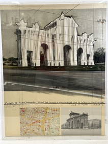
[MAPS]. DUFOUR, Auguste-Henri (1795-1865). Bound Volume of ...Potter & Potter Auctions4.6(545)See Sold PriceMar 07, 2024
De Jode, Rare, pub. 1593 - Map of Africa (Africae Vera Forma, et Situs)Trillium Antique Prints & Rare Books4.5(32)See Sold PriceFeb 24, 2024
1764 Bellin Map of St. Kitts -- Carte de l'Isle St. ChristopheJasper524.5(9.9k)See Sold PriceFeb 27, 2024
WEST AFRICA Niger/Gambia rivers tribes towns. 'Pays des Negres'. MALLET 1683 mapJasper524.5(9.9k)See Sold PriceFeb 28, 2024
La Barbarie de la Nigritie et de la Guinée'. West Africa. DE L’ISLE 1745 mapJasper524.5(9.9k)See Sold PriceFeb 28, 2024
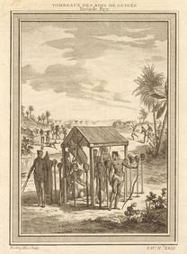
West Africa. Shrines of the Kings of Guinea, from Bry. Heads on stakes 1747Jasper524.5(9.9k)See Sold PriceFeb 28, 2024
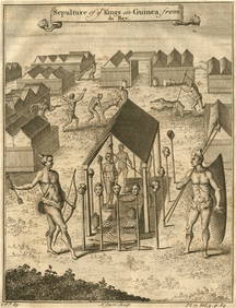
Sepulture of the Kings in Guinea'. Beheadings. Executions. After DE BRY 1746Jasper524.5(9.9k)See Sold PriceFeb 28, 2024
SOUTHERN AFRICA Monomotapa (Mutapa Kingdom) Cafrerie (Kaffraria) MALLET 1683 mapJasper524.5(9.9k)See Sold PriceFeb 28, 2024
FRANCISCO DE TOLEDO ANCIENT THEOLOGY, 1601 BOUND PIGSKIN SUMMA CASUUMNY Elizabeth 4.2(86)See Sold PriceMar 03, 2024
Robert de Vaugondy - Map of Canada - Mer de l' Ouest or Sea of the West and a Northwest PassageProverde Auctions4.3(3)See Sold PriceFeb 28, 2024


![[Strait of Magellan Map] (1 of 1)](https://p1.liveauctioneers.com/268/20476/6999323_1_x.jpg?height=282&quality=70)


![[MINIATURES]. Tiny Playing Cards. Philadelphia: Theodore De... (1 of 4)](https://p1.liveauctioneers.com/928/317913/170626105_1_x.jpg?height=282&quality=70&version=1706650066)
![[MAPS]. DUFOUR, Auguste-Henri (1795-1865). Bound Volume of ... (1 of 2)](https://p1.liveauctioneers.com/928/318880/171361279_1_x.jpg?height=282&quality=70&version=1707501302)