STICH & DRUCK c1888 Map Austrian Alps 20" x 16"Luis Porretta Fine Arts4.3(10)See Sold PriceMar 02, 2024
SoldDe Bry Map of America Sive Novus OrbisDE BRY, Theodore (1528-1598). America Sive Novus Orbis... Pars 1596. Engraved Map. Frankfurt: Theodore de Bry, 1600.14" x 16 1/2" sheet, 23" x 27" framed. ˜ 'Incorporating accurately for the first tiSee Sold Price
SoldDe Bry Map of AmericaDe Bry, Theodore (1528-1598). America Sive Novus Orbis... Pars 1596. Engraved map. Frankfurt: Theodore De Bry, 1600. 14" x 16 1/2" sheet, 23 1/4" framed. A Renaissance map of the Western Hemisphere, iSee Sold Price
De Bry Map of AmericaAmerica sive novus orbis respectu Europaeorum inferior globi terrestris pars 1596. Theodore De Bry (1528-1598). Engraved map. Frankfurt: Theodore de Bry, 1600. 14 x 16 1/2 inches sheet, 23 1/4 x 27 inSee Sold Price
SoldDe Bry (Theodore) America sive Novus Orbis RespectDe Bry (Theodore) America sive Novus Orbis Respectu Europaeorum Inferior Globi Terrestris Pars 1596,hemispheric map of North and South America with Terra Australis Magallanica, ships and sea mSee Sold Price
SoldDE BRY, THEODORE. America Sive Novus Orbis RespectuDE BRY, THEODORE. America Sive Novus Orbis Respectu Europaeorum Inferior Globi Terrestris. Hand-colored double-page engraved map of the Americas. 14x17½ inches sheet size, wide margins; extremelySee Sold Price
SoldMatthias Seutter Map of America - Novus Orbis SiveAntique Map of the Americas Hand Colored Print. Novus Orbis, Sive, America. Depicts Calif as an island.-- Dimensions: Image Size: H: 14 inches: W: 16.25 inches ---See Sold Price
SoldAN ANTIQUE MAP, "Novus Orbis sive America MeridionalisAN ANTIQUE MAP, "Novus Orbis sive America Meridionalis et Septentrionalis," AUGSBURG, CIRCA 1740, hand colored engraving on paper, published by Matthaus Seutter (1687-1757), one cartouche with a sceneSee Sold Price
SoldSeutter, Matthaeus, 1678-1756, 1744 Map: "Novus OrbisSeutter, Matthaeus, 1678-1756, 1744 Map: "Novus Orbis Sive America Meridionalis Et Septentrionalis : divisa per sua regna, provincias et insul: cura et opera. Matth. Seutt. S.C.M. Geogr. Aug. Vind.,,,See Sold Price
Soldc. 1730 MAP of America With California an IslandHistoric Maps Seutter’s Map of the Americas with California as an Island c. 1730 Colonial Era, Historic Hand-Colored Map titled, “NOVUS ORBIS SIVE AMERICA MERIDIONALIS ET SEPTENTRIONALIS...” bySee Sold Price
SoldMAPS: Seutter 1730 Novus Orbis sive AmericaMAPS: Seutter 1730 Novus Orbis sive America, Novus Orbis sive America Meridionalis et Septentrionalis per sua Regna Provincias et Insulas juxta observationes et descriptiones recentiss. divisa et adorSee Sold Price
Mathäus Seutter, Novus Orbis Sive America, Engraving,Matthäus Seutter (1678-1757) – German cartographer and engraver as well as founder of printing and publishing house Seutter Novus Orbis sive America Decorative, colored copper-engraved map of AmeriSee Sold Price
SoldSeutter (Matthaeus) Novus Orbis Sive AmericaSeutter (Matthaeus) Novus Orbis sive America, Meridionalis et Septentrionalis,engraved map with original hand-colouring, 500 x 575mm., damp-staining and surface dirt, a few short splits at theSee Sold Price
SoldMap Matth Seutter 1730 Novus Orbis Sive AmericaMap Matth Seutter (1676-1757). Copper engraving hand colored, map measures approximately 24" L x 20.25" H w/frame approximately 27" W x 23.5" H. Condition: Good, some foxing and center fold mark. NovuSee Sold Price
SoldMatthias Seutter (1678-1757) ''Novus Orbis Sive AmericaMatthias Seutter (1678-1757) ''Novus Orbis Sive America Meridionalis et Septentrionalis . . .'' Circa 1730 Map Engraving 20.5''x23.75'' Sheet. Very early example of this map of the Americas with handSee Sold Price
A MATTHAUS SEUTTER (GERMAN, 1678-1757) ANTIQUE MAP OF TA MATTHAUS SEUTTER (GERMAN, 1678-1757) ANTIQUE MAP OF THE AMERICAS ""NOVUS ORBIS/ SIVE/ AMERICA/MERIDIONALIS ET SEP/TENTRIONALIS"" 1730 AND A PIERRE VANDER (FRENCH, 1659-1733) ANTIQUE MAP OF TURKEY ANSee Sold Price
Soldc. 1730 Seuters Large Map of the AmericasMapsSeutter’s Large Map of the Americas c. 1730, NOVUS ORBIS SIVE AMERICA MERIDOIONALIS ET SEPTENTRIONALIS...”, by Matthew Seutter, Augsburg, Very Fine. 19.5” x 22.75” matted,See Sold Price
SoldMatthaus Seutter map of the Americas Austrian (167Matthaus Seutter map of the Americas Austrian (1678-1757) "Novus Orbis Sive America" hand-colored engraving. (Good condition, trimmed) paper size: H20 1/2" W24"See Sold Price
SoldSeuterÕs Large Map of the AmericasMapsSeutter’s Large Map of the Americas c. 1730, NOVUS ORBIS SIVE AMERICA MERIDOIONALIS ET SEPTENTRIONALIS...”, by Matthew Seutter, Augsburg, Very Fine. 19.5” x 22.75” matted,See Sold Price
SoldSeuters Large Map of the Americas, c. 1730MapsSeutter’s Large Map of the Americas with California as an Island c. 1730, NOVUS ORBIS SIVE AMERICA MERIDOIONALIS ET SEPTENTRIONALIS...”, by Matthew Seutter, Augsburg, Very Fine. 19.5&rSee Sold Price
SoldSeuters Large Map of the Americas, c. 1730MapsSeutter’s Large Map of the Americas with California as an Island c. 1730, NOVUS ORBIS SIVE AMERICA MERIDOIONALIS ET SEPTENTRIONALIS...”, by Matthew Seutter, Augsburg, Very Fine. 19.5&rSee Sold Price
Soldc. 1730 Seuters Large Map of the AmericasMapsSeutter’s Large Map of the Americas c. 1730, NOVUS ORBIS SIVE AMERICA MERIDOIONALIS ET SEPTENTRIONALIS...”, by Matthew Seutter, Augsburg, Very Fine. 19.5” x 22.75” matted,See Sold Price
SoldDetailed Map of The Americas by SeutterNovus Orbis Sive America Meridionalis et Septentrionalis... Matthaus Seutter (1678-1757). Engraved Map with original hand color in part. Ausburg, c. 1730 or later. 21 x 24 1/2 inches sheet, 30 1/2 x 3See Sold Price
SoldMAP, Western Hemisphere, SeutterWestern Hemisphere - America. Matthias Seutter, Novus Orbis sive America Meridionalis et Septentrionalis, per sua Regna, Provincias et Insulas Iuxta Observationes et Descriptiones Recentiss. Divisa etSee Sold Price
SoldSeutter World MapNovus Orbis Sive America Meridionalis et Septentrionalis per sua Regna Provincias et Insulas... Matthias Seutter. Augsburg, circa 1730. Engraved map with hand color in part. 20 x 23 inches visible, 30See Sold Price
De Jode, Rare, pub. 1593 - Map of Luxembourg (Lutzenburgii montuosissimi ac saltuosissimi ducatusTrillium Antique Prints & Rare Books4.5(30)See Sold PriceFeb 24, 2024
De Jode, Rare, pub. 1593 - Map of the British Isles [England, Scotland, Ireland] (Angliae Scotiae etTrillium Antique Prints & Rare Books4.5(30)See Sold PriceFeb 24, 2024
De Jode, Rare, pub. 1593 - Map of Italy (Italiae Totius Orbis olim Domatricis Nova ExactissTrillium Antique Prints & Rare Books4.5(30)See Sold PriceFeb 24, 2024
De Jode, Rare, pub. 1593 - Map of the Czech Republic or Kingdom of Bohemia (Chorographia insignisTrillium Antique Prints & Rare Books4.5(30)See Sold PriceFeb 24, 2024
De Jode, Rare, pub. 1593 - Map of the Middle East, Eastern Asia (Primae Partis Asiae accurataTrillium Antique Prints & Rare Books4.5(30)See Sold PriceFeb 24, 2024
De Jode, Rare, pub. 1593 - Map of Africa (Africae Vera Forma, et Situs)Trillium Antique Prints & Rare Books4.5(30)See Sold PriceFeb 24, 2024
Map: An 18thC engraved and hand coloured map of North America and South America, titled DeClaydon Auctioneers Ltd4.3(125)See Sold PriceFeb 26, 2024
Italian edition of Sanson's map of North America, 1677PBA Galleries4.7(383)See Sold PriceMar 07, 2024
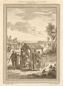
West Africa. Shrines of the Kings of Guinea, from Bry. Heads on stakes 1747Jasper524.5(9.8k)See Sold PriceFeb 28, 2024
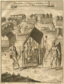
Sepulture of the Kings in Guinea'. Beheadings. Executions. After DE BRY 1746Jasper524.5(9.8k)See Sold PriceFeb 28, 2024
Buffon, Vaugody & Bell 1785 America - Map of the New ContinentAlbion Auctions4.6(341)See Sold PriceMar 01, 2024


![De Jode, Rare, pub. 1593 - Map of the British Isles [England, Scotland, Ireland] (Angliae Scotiae et (1 of 2)](https://p1.liveauctioneers.com/6581/319571/171593327_1_x.jpg?height=282&quality=70&version=1707853304)