ATLAS of ANTIENT GEOGRAPHY by SAMUEL BUTLER 1843John McInnis Auctioneers,LLC4.6(504)See Sold PriceFeb 24, 2024
18TH C. ANTIQUE MAP: FRENCH & INDIAN WAR, FRAMEDThomaston Place Auction Galleries4.4(389)See Sold PriceFeb 24, 2024
Rand McNally Railroad Map Cabinet w/ 21 Railroad MapsRail & Road Auctions4.6(165)See Sold PriceMar 08, 2024
Keith Haring - Ink on New York Map, Best Buddies, Inscribed, Signed, and DatedSapphire Auction Gallery4.1(67)See Sold PriceMar 02, 2024
LATE 17TH C. FRENCH MAP OF THE NEW WORLD BY ALEXIS-HUBERT JAILLOT (1632-1712)Thomaston Place Auction Galleries4.4(389)See Sold PriceFeb 24, 2024
Central Railroad of New Jersey Map of Sandy Hook Route-ca. 1903JM Hobby Supply and Railroad Artifact Auctions4.4(126)See Sold PriceFeb 24, 2024
Lot of Six Mixed Atlas Box Cars-HO Scale-New in BoxJM Hobby Supply and Railroad Artifact Auctions4.4(126)See Sold PriceFeb 25, 2024
Rand McNally/Santa Fe Railroad Map of Iowa-1912JM Hobby Supply and Railroad Artifact Auctions4.4(126)See Sold PriceFeb 24, 2024
NICOLAES VISSCHER (NETHERLANDS, 1618-1709) MAP OF THE NEW WORLDThomaston Place Auction Galleries4.4(389)See Sold PriceFeb 24, 2024
17TH C. WORLD MAP BY NICOLAES VISSCHER (NETHERLANDS, 1618-1709)Thomaston Place Auction Galleries4.4(389)See Sold PriceFeb 24, 2024
Lot of Six Mixed Atlas Cabooses-HO Scale-New in BoxJM Hobby Supply and Railroad Artifact Auctions4.4(126)See Sold PriceFeb 25, 2024
Stoopendaal: Map of Jerusalem, 1714Bird's-eye plan of ancient Jerusalem, with a two-part numbered key to its principal monuments and sites. The central Jerusalem plan is surrounded by portraits of King Soloman and the High Priest, as wSee Sold Price
SoldStoopendaal: Map of Ierusalem, 1714Ierusalem. A superb bird's-eye plan of ancient Jerusalem, with a two-part numbered key to its principal monuments and sites. The central Jerusalem plan is surrounded by portraits of King Soloman and tSee Sold Price
SoldDaniel Stoopendaal & Jacob Keur 1702 Holy LandDaniel Stoopendaal & Jacob Keur 1702 Holy Land Jerusalem Tinted Map 14''x18.5'' Impression. An 18th century hand tinted map titled ''De Gelegentheyt van 't Paradys ende 't Land Canaan mitsgaders de eeSee Sold Price
Stoopendaal, D. Orbis Terrarum Tabula Recens EmendataStoopendaal, Daniel Orbis Terrarum Tabula Recens Emendata et in Lucem Edita C. 1714 Copperplate engraving; old coloured Printed area: 46.3 x 35.6 cm; 18.2 x 14 in This double hemispheric map is basedSee Sold Price
SoldWright, Paul 1782 Holy Land Map. Jerusalem"A Correct Plan of the Antient City of Jerusalem" by Thomas Conder. Folio Copper Plate Published 1782, London for "The Complete British Family Bible…" by Paul Wright. Paper Size: 14.5 x 9.5 inch (37See Sold Price
SoldStoopendaal: Map of Beloved Land of Canaan, 1702Map: Beloved Land of Canaan, "Het Beloofde Landt Canaa" Cartographer: D. Stoopendaal Place & Date: Amsterdam / 1702 Size: 18" x 14" Condition: light overall age-toning, some browning mostly along margSee Sold Price
SoldMAP - Jerusalem, Holy Land. DanckertsJerusalem, Holy Land. Cornelius Danckerts, De Stadt Ierusalem, 1718 (published). Hand Color. Great bird's-eye plan of the ancient holy city flanked by engravings of religious icons. At the bottom areSee Sold Price
SoldEARLY HANDCOLORED MAP (JERUSALEM ) MEASURES 16" X 20EARLY HANDCOLORED MAP (JERUSALEM ) MEASURES 16" X 20 1/2", FROM LOCAL ESTATE….See Sold Price
SoldMap, Jerusalem, Gaspar Bouttats,FlemishFramed antique map engraving, ''Den Bergh uan oliueten''[Jerusalem] ca. 1685, by Gaspar Bouttats (Flemish 1640-1695), after Jacques Peeters, signed in the plate lower right. Condition: Some paper lossSee Sold Price
SoldMap, Jerusalem, Wilkinson, 1807Map, ''The Kingdom of Jerusalem, with it's Environs at the time of the Crusades'', published June 11th, 1807, London, R. Wilkinson, E. Baker, E. Bourne, copper plate engraving, with applied color, sigSee Sold Price
SoldMAP, Jerusalem, Holy Land, I. PutteJerusalem, Holy Land. I. Putte, Ierusalem, 1718 (published). Hand Color. This detailed bird's-eye plan was one of the most popular plans of Jerusalem during the seventeenth century. While it is imaginSee Sold Price
MAP, Jerusalem, Holy Land, SavryJerusalem, Holy Land. Jacob Savry, De Heylige en Wytvermaerde Stadt Ierusalem, Eerst Genaemt Salem, 1648 (dated). Hand Color. This detailed bird's-eye view is based on Claes Janszoon Visscher's depictSee Sold Price
SoldMAP, Jerusalem, Holy Land, VisscherJerusalem, Holy Land. Nicolas Visscher, De Heylige en Wytvermaerde Stadt Ierusalem eerst Genaemt Salem Genesis 14. Vers 18, 1664 (published). Hand Color. This detailed bird's-eye view was one of the mSee Sold Price
SoldMAP, Jerusalem, Holy Land, DetleffsenJerusalem, Holy Land. Johann Detleffsen, Die Heylige und Weitberuhmte Stadt Jerusalem Erstlich Genant Salem..., 1716 (circa). Hand Color. This rare map was published in a German bible by Johann DetlefSee Sold Price
SoldMAP, Jerusalem, Holy Land, VisscherJerusalem, Holy Land. Nicolas Visscher, De Heylige en Wytvermaerde Stadt Ierusalem Eerst Genaemt Salem Genesis 14. Vers 18, 1665 (published). Hand Color. This detailed bird's-eye view was one of the mSee Sold Price
MAP, Jerusalem, Holy Land, AdrichomFirst Edition of Adrichom's Influential Bird's-Eye Plan of Jerusalem. Jerusalem, Holy Land. Christian van Adrichom, Ierusalem I., et Suburbia eius, Sicut Tempore Christi Floruit, cum Locis, in QuibusSee Sold Price
SoldMap. Jerusalem. Coccejus Johannes Heinrich. Amsterdam,Ierusalemniewlicksuyt de SchriftenIosephusafgebeeld door. Imaginary map, historic, of Jerusalem by Coccejus Johannes Heinrich. According to the book of Josephus Flavius: Alle de werken, p. 655 (in theSee Sold Price
Map. Jerusalem. Coccejus Johannes Heinrich. Amsterdam,Ierusalemniewlicksuyt de SchriftenIosephusafgebeeld door. Imaginary map, historic, of Jerusalem by Coccejus Johannes Heinrich. According to the book of Josephus Flavius: Alle de werken, p. 655 (in theSee Sold Price
SoldMap of Jerusalem and Its Ruins, 1872Map: Jerusalem and Its Ruins Maker: Redding & Co Date: 1872 Size: Folio, 15.3 inches high x 19.75 inches wide Detailed plan of ancient biblical sites in the Holy City. Fine, Large Plan of Jerusalem PlSee Sold Price
SoldI.H. Coccejo / Weigel: Map of Jerusalem, 1720Map: Jerusalem, "Ierusalem aus den Schrifften Iosephi" Cartographer: I.H. Coccejo. / Weigel Place & Date: Nuremberg / 1720 Size: 16 5/8" x 13" Condition: original color; overall age toning and minor sSee Sold Price
SoldModern Jerusalem, 1858Map: Jerusalem before the Roman Destruction Publishing: Sarony & Major, 1858 Medium: Hand colored lithograph Size: 13.5 x 15 inches Napoleon Sarony (1821-1896) was an American lithographer and a highlSee Sold Price
1714 Chatelain Map of Sri Lanka -- Nouvelle Carte deReserve Reduced! Title/Content of Map: 1714 Chatelain Map of Sri Lanka -- Nouvelle Carte de l'Ile de Ceylon, avec des Remarques Historiques Date: 1714 c., Amsterdam Cartographer: H Chatelain Size: 15.See Sold Price
Moll: Antique Map of North Africa, 1714Title/Content of Map: 1714 Moll Map of North Africa -- The East Part of Barbary Containing Tunis, Tripoli. Barca, Egypt, Nubia, Part of Biledul… Date Printed: 1714 c., London Cartographer: H Moll SiSee Sold Price
SoldJerusalem & Palestine 1889Title/Content of Map: Jerusalem & Palestine 1889 Date Printed: 1889 Material/Medium: Paper Size: approx 11x14 inches Mast, Crowell & Kirkpatrick, Peerless Atlas of the World Reserve: $30.00 Shipping:See Sold Price
Jerusalem Map for British Soldiers in Palestine - WW2Levy Auction House4.3(11)See Sold PriceFeb 27, 2024
Illustrated Sabbath Cloth - Holy Sites of Eretz IsraelLevy Auction House4.3(11)See Sold PriceFeb 27, 2024
[MAPS]. DUFOUR, Auguste-Henri (1795-1865). Bound Volume of ...Potter & Potter Auctions4.6(544)See Sold PriceMar 07, 2024
1738 BIBLE in DUTCH ILLUSTRATED w/ MAPS MASSIVE FOLIO in DUTCH antique BIBLIAJasper524.5(9.8k)See Sold PriceFeb 27, 2024
1738 BIBLE in DUTCH ILLUSTRATED w/ MAPS antique MASSIVE FOLIO BIBLIAJasper524.5(9.8k)See Sold PriceFeb 27, 2024
1730 BIBLE in DUTCH ILLUSTRATED w/ MAPS antique MASSIVE FOLIO BIBLIAJasper524.5(9.8k)See Sold PriceFeb 27, 2024
Georg Bockler Map of Ancient Jerulsaem EtchingAuctions at Showplace4.6(731)See Sold PriceApr 07, 2024
Antoine Augustin Calmet (1672-1757) - Set of 6 Architecture Engraving - Temple of Jerusalem -Proverde Auctions4.3(3)See Sold PriceFeb 28, 2024
Jean-Francois de Neufforge (1714 - 1791) - Set of 15 Architecture Prints - Development pour unProverde Auctions4.3(3)See Sold PriceFeb 28, 2024
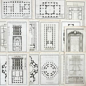
Jean-Francois de Neufforge (1714 - 1791) - Set of 15 Architecture Prints - Plan de l' EdificeProverde Auctions4.3(3)See Sold PriceFeb 28, 2024


![[MAPS]. DUFOUR, Auguste-Henri (1795-1865). Bound Volume of ... (1 of 2)](https://p1.liveauctioneers.com/928/318880/171361279_1_x.jpg?height=282&quality=70&version=1707501302)