ATLAS of ANTIENT GEOGRAPHY by SAMUEL BUTLER 1843John McInnis Auctioneers,LLC4.6(504)See Sold PriceFeb 24, 2024
18TH C. ANTIQUE MAP: FRENCH & INDIAN WAR, FRAMEDThomaston Place Auction Galleries4.4(389)See Sold PriceFeb 24, 2024
Rand McNally Railroad Map Cabinet w/ 21 Railroad MapsRail & Road Auctions4.6(165)See Sold PriceMar 08, 2024
Keith Haring - Ink on New York Map, Best Buddies, Inscribed, Signed, and DatedSapphire Auction Gallery4.1(67)See Sold PriceMar 02, 2024
LATE 17TH C. FRENCH MAP OF THE NEW WORLD BY ALEXIS-HUBERT JAILLOT (1632-1712)Thomaston Place Auction Galleries4.4(389)See Sold PriceFeb 24, 2024
Central Railroad of New Jersey Map of Sandy Hook Route-ca. 1903JM Hobby Supply and Railroad Artifact Auctions4.4(126)See Sold PriceFeb 24, 2024
Lot of Six Mixed Atlas Box Cars-HO Scale-New in BoxJM Hobby Supply and Railroad Artifact Auctions4.4(126)See Sold PriceFeb 25, 2024
Rand McNally/Santa Fe Railroad Map of Iowa-1912JM Hobby Supply and Railroad Artifact Auctions4.4(126)See Sold PriceFeb 24, 2024
NICOLAES VISSCHER (NETHERLANDS, 1618-1709) MAP OF THE NEW WORLDThomaston Place Auction Galleries4.4(389)See Sold PriceFeb 24, 2024
17TH C. WORLD MAP BY NICOLAES VISSCHER (NETHERLANDS, 1618-1709)Thomaston Place Auction Galleries4.4(389)See Sold PriceFeb 24, 2024
Lot of Six Mixed Atlas Cabooses-HO Scale-New in BoxJM Hobby Supply and Railroad Artifact Auctions4.4(126)See Sold PriceFeb 25, 2024
SoldStoopendaal: Map of Ierusalem, 1714Ierusalem. A superb bird's-eye plan of ancient Jerusalem, with a two-part numbered key to its principal monuments and sites. The central Jerusalem plan is surrounded by portraits of King Soloman and tSee Sold Price
Stoopendaal: Map of Jerusalem, 1714Bird's-eye plan of ancient Jerusalem, with a two-part numbered key to its principal monuments and sites. The central Jerusalem plan is surrounded by portraits of King Soloman and the High Priest, as wSee Sold Price
Stoopendaal, D. Orbis Terrarum Tabula Recens EmendataStoopendaal, Daniel Orbis Terrarum Tabula Recens Emendata et in Lucem Edita C. 1714 Copperplate engraving; old coloured Printed area: 46.3 x 35.6 cm; 18.2 x 14 in This double hemispheric map is basedSee Sold Price
SoldStoopendaal: Map of Beloved Land of Canaan, 1702Map: Beloved Land of Canaan, "Het Beloofde Landt Canaa" Cartographer: D. Stoopendaal Place & Date: Amsterdam / 1702 Size: 18" x 14" Condition: light overall age-toning, some browning mostly along margSee Sold Price
1714 Chatelain Map of Sri Lanka -- Nouvelle Carte deReserve Reduced! Title/Content of Map: 1714 Chatelain Map of Sri Lanka -- Nouvelle Carte de l'Ile de Ceylon, avec des Remarques Historiques Date: 1714 c., Amsterdam Cartographer: H Chatelain Size: 15.See Sold Price
Moll: Antique Map of North Africa, 1714Title/Content of Map: 1714 Moll Map of North Africa -- The East Part of Barbary Containing Tunis, Tripoli. Barca, Egypt, Nubia, Part of Biledul… Date Printed: 1714 c., London Cartographer: H Moll SiSee Sold Price
Sold1714 Moll Map of North Africa -- The East Part ofTitle/Content of Map: 1714 Moll Map of North Africa -- The East Part of Barbary Containing Tunis, Tripoli. Barca, Egypt, Nubia, Part of Biledul… Date: 1714 c., London Cartographer: H Moll Size: 6.9See Sold Price
1714 Chatelain Map of Sri Lanka -- Nouvelle Carte deTitle/Content of Map: 1714 Chatelain Map of Sri Lanka -- Nouvelle Carte de l'Ile de Ceylon, avec des Remarques Historiques Date: 1714 c., Amsterdam Cartographer: H Chatelain Size: 15.2 X 17.3 in. ThisSee Sold Price
Sold1714 Chatelain Map of Sri Lanka -- Nouvelle Carte deTitle/Content of Map: 1714 Chatelain Map of Sri Lanka -- Nouvelle Carte de l'Ile de Ceylon, avec des Remarques Historiques Date: 1714 c., Amsterdam Cartographer: H Chatelain Size: 15.2 X 17.3 in. ThisSee Sold Price
1714 Chatelain Map of Sri Lanka -- Nouvelle Carte deTitle/Content of Map: 1714 Chatelain Map of Sri Lanka -- Nouvelle Carte de l'Ile de Ceylon, avec des Remarques Historiques Date: 1714 c., Amsterdam Cartographer: H Chatelain Size: 15.2 X 17.3 in. ThisSee Sold Price
1714 Chatelain Map of Sri Lanka -- Nouvelle Carte deTitle/Content of Map: 1714 Chatelain Map of Sri Lanka -- Nouvelle Carte de l'Ile de Ceylon, avec des Remarques Historiques Date: 1714 c., Amsterdam Cartographer: H Chatelain Size: 15.2 X 17.3 in. ThisSee Sold Price
1714 Moll Map of North Africa -- The East Part ofTitle/Content of Map: 1714 Moll Map of North Africa -- The East Part of Barbary Containing Tunis, Tripoli. Barca, Egypt, Nubia, Part of Biledul… Date: 1714 c., London Cartographer: H Moll Size: 6.9See Sold Price
1714 Moll Antique Map of North AfricaTitle/Content of Map: 1714 Moll Map of North Africa -- The East Part of Barbary Containing Tunis, Tripoli. Barca, Egypt, Nubia, Part of Biledul… Date Printed: 1714 c., London Cartographer: H Moll SiSee Sold Price
Moll: Antique Map of North Africa, 1714Title/Content of Map: 1714 Moll Map of North Africa -- The East Part of Barbary Containing Tunis, Tripoli. Barca, Egypt, Nubia, Part of Biledul… Date Printed: 1714 c., London Cartographer: H Moll SiSee Sold Price
1714 Moll Map of North Africa -- The East Part ofTitle/Content of Map: 1714 Moll Map of North Africa -- The East Part of Barbary Containing Tunis, Tripoli. Barca, Egypt, Nubia, Part of Biledul… Date Printed: 1714 c., London Cartographer: H Moll SiSee Sold Price
Sold1714 Map Of Livingston New York1714 map of Livingston N.Y., marked "Performed this 20th day of October, 1714...John Beatty Dep. Surv'r". Sight 9" x 10 1/2".See Sold Price
SoldDaniel Stoopendaal World MapOrbis Terrarum Tabula Recens Emendata et in Lucem Edita Per N. Visscher. Outstanding example of the Dutch Keur bible world map by Daniel Stoopendael in beautiful old hand coloring. The map is based onSee Sold Price
Daniel Stoopendaal World MapOrbis Terrarum Tabula Recens Emendata et in Lucem Edita Per N. Visscher. Outstanding example of the Dutch Keur bible world map by Daniel Stoopendael in beautiful old hand coloring. The map is based onSee Sold Price
SoldDaniel Stoopendaal World MapOrbis Terrarum Tabula Recens Emendata et in Lucem Edita Per N. Visscher. Outstanding example of the Dutch Keur bible world map by Daniel Stoopendael in beautiful old hand coloring. The map is based onSee Sold Price
SoldHoly land by Stoopendaal, Bible map. 1738-1740,Title: Holy land by Stoopendaal, Bible map. 1738-1740, Rotterdam Date/Period: 1738-1740 Materials: Copperplate engravedSize: 18” x 13”. Canaan / Holy land (oriented with north to the right). By DaSee Sold Price
SoldH. Moll, 1714, Map of ItalyDedicated to Francisco Eugenio. Hand colored. Tears to bottom and middle of map at folds. Left corner detached but present. Losses at tears impact map. Mold. 40" wide x 24" high. IMPORTANT: Before bidSee Sold Price
SoldDouble-hemisphere world map StoopendaalFramed handcolored double-hemisphere engraved world map, Orbis Terrarum Tabula Recens Emendata et in Lucem Edita, by D. Stoopendaal, sight: 14.25''H x 18.5''WSee Sold Price
Soldc. 1714, Map: Plantations of English in AmericaMaps“A New Map of the Most Considerable Plantations of the English in America” c. 1714, Hand-colored “A New Map of the Most Considerable Plantations of the English in America,&rdquoSee Sold Price
1714 Map of Northern HemisphereA View of the Northern Hemisphere from the North Pole 1714, "HEMISPHERE SEPTENTRIONAL LES TERRES ARCTIQUES..." by Guillaume Delisle, Paris, France, Choice Very Fine. Plate size 18.5" x 18.25"; overallSee Sold Price
Central Railroad of New Jersey Map of Sandy Hook Route-ca. 1903JM Hobby Supply and Railroad Artifact Auctions4.4(126)See Sold PriceFeb 24, 2024
Rand McNally/Santa Fe Railroad Map of Iowa-1912JM Hobby Supply and Railroad Artifact Auctions4.4(126)See Sold PriceFeb 24, 2024
LATE 17TH C. FRENCH MAP OF THE NEW WORLD BY ALEXIS-HUBERT JAILLOT (1632-1712)Thomaston Place Auction Galleries4.4(389)See Sold PriceFeb 24, 2024
18TH C. ANTIQUE MAP: FRENCH & INDIAN WAR, FRAMEDThomaston Place Auction Galleries4.4(389)See Sold PriceFeb 24, 2024
NICOLAES VISSCHER (NETHERLANDS, 1618-1709) MAP OF THE NEW WORLDThomaston Place Auction Galleries4.4(389)See Sold PriceFeb 24, 2024
Keith Haring - Ink on New York Map, Best Buddies, Inscribed, Signed, and DatedSapphire Auction Gallery4.1(67)See Sold PriceMar 02, 2024
Rand McNally Railroad Map Cabinet w/ 21 Railroad MapsRail & Road Auctions4.6(165)See Sold PriceMar 08, 2024
Putnam - First Map of the State of Ohio by Rufus PutnamTrillium Antique Prints & Rare Books4.5(30)See Sold PriceFeb 24, 2024
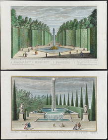
Demortain - 4 Fountain & Garden EngravingsTrillium Antique Prints & Rare Books4.5(30)See Sold PriceFeb 24, 2024
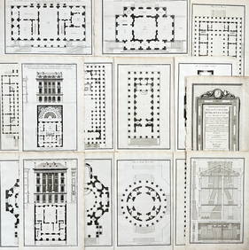
Jean-Francois de Neufforge (1714 - 1791) - Set of 15 Architecture Prints - Development pour unProverde Auctions4.3(3)See Sold PriceFeb 28, 2024
Jean-Francois de Neufforge (1714 - 1791) - Set of 15 Architecture Prints - Plan de l' EdificeProverde Auctions4.3(3)See Sold PriceFeb 28, 2024