ATLAS of ANTIENT GEOGRAPHY by SAMUEL BUTLER 1843John McInnis Auctioneers,LLC4.6(502)See Sold PriceFeb 24, 2024
18TH C. ANTIQUE MAP: FRENCH & INDIAN WAR, FRAMEDThomaston Place Auction Galleries4.4(386)See Sold PriceFeb 24, 2024
Rand McNally Railroad Map Cabinet w/ 21 Railroad MapsRail & Road Auctions4.6(165)See Sold PriceMar 08, 2024
Keith Haring - Ink on New York Map, Best Buddies, Inscribed, Signed, and DatedSapphire Auction Gallery4(67)See Sold PriceMar 02, 2024
LATE 17TH C. FRENCH MAP OF THE NEW WORLD BY ALEXIS-HUBERT JAILLOT (1632-1712)Thomaston Place Auction Galleries4.4(386)See Sold PriceFeb 24, 2024
Central Railroad of New Jersey Map of Sandy Hook Route-ca. 1903JM Hobby Supply and Railroad Artifact Auctions4.4(126)See Sold PriceFeb 24, 2024
Lot of Six Mixed Atlas Box Cars-HO Scale-New in BoxJM Hobby Supply and Railroad Artifact Auctions4.4(126)See Sold PriceFeb 25, 2024
Rand McNally/Santa Fe Railroad Map of Iowa-1912JM Hobby Supply and Railroad Artifact Auctions4.4(126)See Sold PriceFeb 24, 2024
NICOLAES VISSCHER (NETHERLANDS, 1618-1709) MAP OF THE NEW WORLDThomaston Place Auction Galleries4.4(386)See Sold PriceFeb 24, 2024
17TH C. WORLD MAP BY NICOLAES VISSCHER (NETHERLANDS, 1618-1709)Thomaston Place Auction Galleries4.4(386)See Sold PriceFeb 24, 2024
Lot of Six Mixed Atlas Cabooses-HO Scale-New in BoxJM Hobby Supply and Railroad Artifact Auctions4.4(126)See Sold PriceFeb 25, 2024
South Asia. British & Farther India. Indochina. Ethnographic. TIMES 1922 mapTITLE/CONTENT OF MAP: 'India & Farther India - Political' DATE PRINTED: 1922 IMAGE SIZE: Approx 44.5 x 57.0cm, 17.5 x 22.5 inches (Large); Please note that this is a folding map. TYPE: Antique atlas mSee Sold Price
South Asia. British & Farther India. Indochina. Ethnographic. TIMES 1922 mapTITLE/CONTENT OF MAP: 'India & Farther India - Political' DATE PRINTED: 1922 IMAGE SIZE: Approx 44.5 x 57.0cm, 17.5 x 22.5 inches (Large); Please note that this is a folding map. TYPE: Antique atlas mSee Sold Price
Hindoostan, Farther India, China & Tibet. South Asia Indochina MITCHELL 1869 mapTITLE/CONTENT OF MAP: 'Map of Hindoostan, Farther India, China, and Tibet' DATE PRINTED: 1869 IMAGE SIZE: Approx 30.0 x 37.0cm, 11.75 x 14.5 inches (Large) TYPE: Decorative antique atlas map with origSee Sold Price
ASIA. Russia China British India Oman Arabia Persia Siam. STANFORD 1906 mapTITLE/CONTENT OF MAP: 'Asia' DATE PRINTED: 1906 IMAGE SIZE: Approx 26.0 x 32.0cm, 10.25 x 12.5 inches (Large); Please note that this is a folding map. TYPE: Colour antique map. Scale 1: 38,016,000 CONSee Sold Price
Sold1885 Burnaby Ride to KHIVA Uzbekistan Russia China MAPS1885 Burnaby Ride to KHIVA Uzbekistan Russia China MAPS Central Asia Voyages Frederick Burnaby was an intelligence offer in the British Army in the 19th-century. He spent much of his career travelingSee Sold Price
Smith: Map of Asia [verso] South Central Europe, 1894Map: 1894 Smith Map of Asia [verso] South Central Europe -- Map of Asia Showing its Geopolitical Divisions, and also the Various Routes of Travel between London & India, China & Japan &c. [verso] AustSee Sold Price
SoldAn important map of Asia, c1680 by Frederick De WitAn important map of Asia, c1680 by Frederick De Wit depicting the area of Asia, including China, Japan, Tibet, India, Russia, Persia, Arab and more (center folding area repair), 19.5"x23"See Sold Price
Sold6 19th c. hand-colored maps of Asia6 19th c. hand-colored maps of Asia- ''Map of Asia Showing Its Political Divisions''; ''Map of Hindoostan, Farther India, China and Tibet''; ''China''; ''Asia'' (2 copies); Russia in Asia and Tartary'See Sold Price
SoldSmith: Antique Map of Asia, 1894Map: 1894 Smith Map of Asia [verso] South Central Europe -- Map of Asia Showing its Geopolitical Divisions, and also the Various Routes of Travel between London & India, China & Japan &c. [verso] AustSee Sold Price
SoldASIA. India China Arabia Russia Persia. British BurmaTITLE/CONTENT OF MAP: 'ASIA' DATE PRINTED: 1846 IMAGE SIZE: Approx 34.0 x 41.0cm, 13.25 x 16 inches (Large) TYPE: Antique steel engraved map with original outline hand colouring CONDITION: Fair: SpottSee Sold Price
SoldAsia.- Brion de la Tour (Louis) L'Asie, 1784.Asia.- Brion de la Tour (Louis) L'Asie, large detailed map showing from the Arabian Peninsula to New Guinea and part of Australia, including India, China, Russia, and the countries of South East Asia,See Sold Price
Asia.- Brion de la Tour (Louis) L'Asie, 1784.Asia.- Brion de la Tour (Louis) L'Asie, large detailed map showing from the Arabian Peninsula to New Guinea and part of Australia, including India, China, Russia, and the countries of South East Asia,See Sold Price
SoldBartholomew, John 1922 Group of 3 Maps of AsiaSouth Western Asia, Asia - Political, and Father India showing Siam and Indo China. Large Lithograph Maps Published 1922 by The Times, London for "The Times Survey Atlas of the World" Maps by John GeoSee Sold Price
SoldGross, Alexander 1920 Mixed Lot of 5 Large MapsIncl British Island Possessions, Centrel America & Panama, Indian Ocean, Central Asia, and Russia - South West. Large Lithograph Maps Published 1920, London for "The Daily Telegraph Victory Atlas of tSee Sold Price
Gross, Alexander 1920 Mixed Lot of 5 Large MapsIncl British Island Possessions, Centrel America & Panama, Indian Ocean, Central Asia, and Russia - South West. Large Lithograph Maps Published 1920, London for "The Daily Telegraph Victory Atlas of tSee Sold Price
Antique Map of East Asia - China - Japan - 19th Century - Korea - Central AsiaA fine first edition example of M. Lapie's 1832 map of the Chinese empire and Japan. The map covers all of China, Korea, and Japan from Asiatic Russia to India and the Sea of China and from IndependenSee Sold Price
SoldDe l'Isle (G) Carte des Indes et De La ChineDe l'Isle (Guillaume) Carte des Indes et De La Chine, India, China, Japan and south east Asia, engraved map with original outline hand-colouring, 630 x 660mm., on two sheets, joined, central vSee Sold Price
SoldRuscelli (Girolamo) - India Tercera Nuova Tavola,South East Asia from the Bay of Bengal to Southern China, including Java and Timor, titled above, engraved map, 185 x 260mm., Italian text verso, slight browning on central vertical fold, Venice, [c.1See Sold Price
Les Indes Orientales… South Asia India Indochina Tibet. VAUGONDY 1751 mapTITLE OF MAP (NOT PRINTED ON THE PAGE):'Les Indes Orientales, où sont distingués les empires et Royaumes qu'elles contiennent, tirées du Neptune Oriental. Par le S. Robert GéographSee Sold Price
Les Indes Orientales… South Asia India Indochina Tibet. VAUGONDY 1751 mapTITLE OF MAP (NOT PRINTED ON THE PAGE):'Les Indes Orientales, où sont distingués les empires et Royaumes qu'elles contiennent, tirées du Neptune Oriental. Par le S. Robert GéographSee Sold Price
Antique Original Map - Central Asia - Tibet - India - Pakistan - AfghanistanDiscover the Timeless Beauty of "Indien & Inner-Asien, Nordliches Bl": An Exquisite Cartographic Gem. This exquisite cartographic masterpiece invites you on a journey through the enchanting lands of ISee Sold Price
South Siberia & Turkestan. Central East Asia. Mongolia China. BAEDEKER 1912 mapTITLE/CONTENT OF MAP: Südsibirien und Turkestan [South Siberia and Turkestan] DATE PRINTED: 1912 IMAGE SIZE: Approx 22.0 x 51.5cm, 8.75 x 20.25 inches (Large); Please note that this is a foldingSee Sold Price
SoldAncient Central Asia. China Tibet parts as wellTitle/Content of Map: Ancient Central Asia. China Tibet parts as well Date: 1598/99 Cartographer: By Ruscelli Size: 11x9”Provenance: Venice Reserve: $75.00 Shipping: Domestic: Free shipping to anywhSee Sold Price
Ancient Central Asia. China Tibet parts as wellReserve Reduced! Title/Content of Map: Ancient Central Asia. China Tibet parts as well Date: 1598/99. Size: 11x9” Additional Info: By Ruscelli Venice Reserve: $175.00 Jasper52 negotiates the lowestSee Sold Price
1789 Captain James Cook Life & Voyages Australia New Zealand Hawaii KippisSchilb Antiquarian Rare Books4.8(421)See Sold PriceMar 10, 2024
LATE 17TH C. FRENCH MAP OF THE NEW WORLD BY ALEXIS-HUBERT JAILLOT (1632-1712)Thomaston Place Auction Galleries4.4(386)See Sold PriceFeb 24, 2024
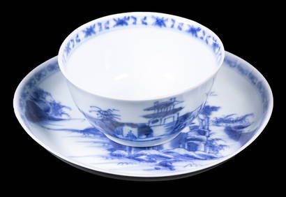
CHINESE NANKING CARGO CUP & SAUCERThomaston Place Auction Galleries4.4(386)See Sold PriceFeb 24, 2024
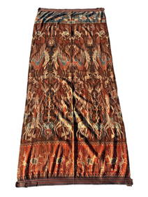
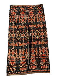
A Fine RARE Antique Woven ikat Pictorial TextilePremier Auction Galleries4.3(329)See Sold PriceMar 09, 2024
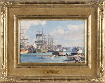
JOHN STOBART (Massachusetts/Florida/England, 1929-2023), "Victoria, View from Songhee Point, 1891".,Eldred's4.7(409)See Sold PriceFeb 27, 2024
India Bronze Statue Man on Horseback.China Luban Art & Antique, Inc.4.4(78)See Sold PriceFeb 24, 2024
Asian Stone Carved Buddha Head on Wood StandChina Luban Art & Antique, Inc.4.4(78)See Sold PriceFeb 24, 2024
Vaillant - Hawaiian Dance (Scene de Danse aux Iles Sandwich). 42Trillium Antique Prints & Rare Books4.5(30)See Sold PriceFeb 24, 2024
Unusual Large Antique Chinese Rose Canton Export Porcelain ChargerAkiba Galleries4.7(1.7k)See Sold PriceFeb 29, 2024
Chinese Early 20th Cent. Large Famille Rose Porcelain PlateAkiba Galleries4.7(1.7k)See Sold PriceFeb 29, 2024
(7 Pc) Antique Chinese Export Bok Choy Medallion DishwareAkiba Galleries4.7(1.7k)See Sold PriceFeb 29, 2024
Colonial Southern Africa. British Portuguese German. Madagascar. TIMES 1895 mapJasper524.5(9.8k)See Sold PriceFeb 28, 2024
19th C. Tibetan Brass Torana / Mandorla (from Statue)Artemis Fine Arts4.8(1.4k)See Sold PriceMar 01, 2024


![Smith: Map of Asia [verso] South Central Europe, 1894 (1 of 2)](https://p1.liveauctioneers.com/5584/103242/52831702_1_x.jpg?height=282&quality=70&version=1493321322)