SoldSmith (Chalres) - Smith's Map of England & Walesengraved map, with hand-colouring, on two sheets joined, 795 x 625mm., dissected and backed on linen, light spotting and browning, minor surface dirt, in contemporary cloth covered slipcase, with origSee Sold Price
Smith (Charles) - Smith's Map of England & Walesengraved map", with hand-colouring, on two sheets joined, 795 x 625mm., dissected and backed on linen, light spotting and browning, minor surface dirt, in contemporary cloth covered slipcase, with oriSee Sold Price
SoldEngland & Wales.- Smith (Charles) Smith's New Map ofEngland & Wales.- Smith (Charles) Smith's New Map of the Inland Navigation of England & Wales, with details of the inland waterways, or rivers and canals, of England and Wales, engraving with originalSee Sold Price
Smith's Map of England & Wales, 1834Title: Smith's Map of England & Wales, Containing the Whole of the Turnpike Roads, Rivers & Canals with the Distance from London to every Principal Town, and from one Market Town to Another Author: SmSee Sold Price
SoldSmith (Charles) - Smith's New English Atlas,first edition, bound as a folded-over travelling atlas, ornately lettered engraved title, 45 of 46 maps, including general map of England and Wales, Yorkshire on 4 sheets and Wales on 2 sheets, but laSee Sold Price
SoldBritish Isles.- Smith & Son (Charles) A GeologicalBritish Isles.- Smith & Son (Charles) A Geological Railway & Canal Map of England, Wales and part of Scotland, inset map of 'Canals and Railways around Birmingham' in the lower right corner, alongsideSee Sold Price
SoldGeology.- Phillips (John) Memoirs of William Smith,Geology.- Phillips (John) Memoirs of William Smith, LL.D., Author of "Map of the Strata of England and Wales", first edition, 5 engraved or lithographed portraits (1 as frontipsiece), illustrations, 8See Sold Price
SoldMARY SMITH, 1794 NEEDLEWORK MAPMARY SMITH, 1794 NEEDLEWORK MAP, silk on linen, "A MAP OF ENGLAND AND WALES", lower edge inscribed "Mary Smith / November 19 / 1794", all within an undulating flower and vine border. Period, possiblySee Sold Price
Smith (Charles) New English AtlasSmith (Charles) New English Atlas, engraved title, 25 engraved maps (of 42), including general map of England and Wales, and Yorkshire on 4 sheets, with original hand-colouring, the majority dSee Sold Price
SoldSmith (Harry Worcester)Smith (Harry Worcester) A Sporting Tour through Ireland, England, Wales and France, in the Years 1912-1913, The Bookplate Edition, 2 vol., bookplate signed by the author, plates and maps, someSee Sold Price
SoldCary (John) Cary's Six Sheet Map of England and WaCary (John) Cary's Six Sheet Map of England and Wales with Part of Scotland,engraved map, outline colouring, disected onto linen, 1350 x 1080mm, 1818 § Smith's New Map of England and Wales witSee Sold Price
Selection of 18th Century Maps To include 1818...Selection of 18th Century Maps To include 1818 map of Wales by C Smith, Black's Travelling map of England, Cruchley's Cornwall, Humphrey's North Wales, Gall and Inglis Scarborough, Kitchin's Roads ofSee Sold Price
SoldSmith's Rail Road, Steam Boat & Stage Route Map...[New York/New England] J. Calvin Smith. SMITH’S RAIL ROAD, STEAM BOAT & STAGE ROUTE MAP OF NEW ENGLAND, NEW-YORK AND CANADA. Pocket map. Front cover title: SHERMAN & SMITH’S ILLUSTRATED RAILROAD SSee Sold Price
SoldJOHN SMITH'S MAP OF NEW ENGLAND"NEW ENGLAND The most remarqueable parts thus named by the high and might Prince CHARLES, Prince of Great Britaine", colored engraving, made by John Smith, engraved by Simon Passaeus, and printed by JSee Sold Price
SoldA large folding 'new map' of England and Wales and partA large folding 'new map' of England and Wales and part of Scotland by Smiths published London 1806, corrected to 1818. 116 x 93cm.See Sold Price
Sold1884 Captain John Smith Works maps New England VirginiaHard bound. Printed in England in 1884 Maps with some acid free tape repairs. Back cover is almost detached. Size 5 3/4 by 8" 982 pages Please note that this lot has a confidential reserve. When you lSee Sold Price
SoldGeogloical mapJ A Knipe - 'Geological & Mineralogical Map of England and Wales with parts of Scotland, Ireland & France...' with forty-nine linen-backed sections, published 1884, 116 x 85 cm overall, with oil-paperSee Sold Price
MAP, New England US, SmithGerman Edition of Capt. John Smith's Foundation Map of New England. Colonial New England United States. Capt. John Smith, New England die Mercklichsten Dheile..., from , 1617 (circa). Black & White. TSee Sold Price
An early 18th century German map engraving of EnglandAn early 18th century German map engraving of England and Wales, 'Regnum Angliae', by John Baptiste Homann, Nuremberg, 57 x 49 cm, framed and glazedSee Sold Price
SoldAn early 18th century German map engraving of EnglandAn early 18th century German map engraving of England and Wales, 'Regnum Angliae', by John Baptiste Homann, Nuremberg, 57 x 49 cm, framed and glazed to/w a 17th century county map engraving of CornwalSee Sold Price
SoldCaptain John Smith New England Scroll MapCaptain John Smith scroll map depicting Smith's Portraictuer Of The New England Coast in 1614. Map is printed on paper affixed to linen. Dated 1614.See Sold Price
Sold287: Smith, Captain John. The Generall Historie Of VirSmith, Captain John. The Generall Historie Of Virginia, New-England, And The Summer Iles. 1624. [Cleveland: World Publishing Co., 1966]. Full vellum in clamshell box. Includes Smith's map of Virginia.See Sold Price
SoldSmith (Harry Worcester)Smith (Harry Worcester) A Sporting Tour through Ireland, England, Wales and France, in the Years 1912-1913, 2 vol., the author's proof copy, presentation copy to the bookseller Charles SessleSee Sold Price
SoldHaskett Smith Climbing in the British IslesHaskett Smith (W.P.) Climbing in the British Isles,England, 1894; Wales & Ireland, 1895, illustrations, original pictorial cloth, spines faded § Palmer (W.T.) The Complete Hill Walker, Rock ClSee Sold Price
OGILVY & BOWEN c1736 Original Map of Oxfordshire Berkshire Etc.Luis Porretta Fine Arts4.3(10)See Sold PriceMar 02, 2024
Archaeological Books - Roach Smith - Collectanea Antiqua, etchings and notices of ancient remains,TimeLine Auctions Ltd.4.5(183)See Sold PriceMar 06, 2024
Numismatic Books - Boyne - Tokens Issued in the Seventeenth Century in England, Wales, and IrelandTimeLine Auctions Ltd.4.5(183)See Sold PriceMar 09, 2024
Jules Andre Smith, Robin Hood's BayLotus International Auctions, LLC4.6(153)See Sold PriceMar 03, 2024
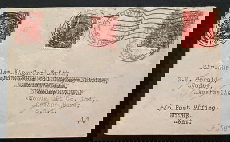
1935 Darwin Australia Experimental flight Cover To England Charles Smith Only 49Mynt Auctions4.6(680)See Sold PriceFeb 24, 2024
Birmingham.- Commercial map.- Smith (J. Pigott) To the Right Honourable William Earl of Dartmouth...Forum Auctions4.3(52)See Sold PriceFeb 29, 2024
Smith and Bartlam English Estate Sterling Silver Match Safe Vermeil Ivy -2Bidhaus4.3(747)See Sold PriceMar 04, 2024
Late 18th century map of England and Wales sampler and two printsFellows4.3(159)See Sold PriceMar 05, 2024
SHORTLAND SMITHS Vntg Wooden Barometer 3ftThe Benefit Shop Foundation Inc.4.3(2.9k)See Sold PriceMar 20, 2024