ATLAS of ANTIENT GEOGRAPHY by SAMUEL BUTLER 1843John McInnis Auctioneers,LLC4.5(505)See Sold PriceFeb 24, 2024
18TH C. ANTIQUE MAP: FRENCH & INDIAN WAR, FRAMEDThomaston Place Auction Galleries4.4(393)See Sold PriceFeb 24, 2024
Rand McNally Railroad Map Cabinet w/ 21 Railroad MapsRail & Road Auctions4.6(165)See Sold PriceMar 08, 2024
Keith Haring - Ink on New York Map, Best Buddies, Inscribed, Signed, and DatedSapphire Auction Gallery4.1(67)See Sold PriceMar 02, 2024
LATE 17TH C. FRENCH MAP OF THE NEW WORLD BY ALEXIS-HUBERT JAILLOT (1632-1712)Thomaston Place Auction Galleries4.4(393)See Sold PriceFeb 24, 2024
Central Railroad of New Jersey Map of Sandy Hook Route-ca. 1903JM Hobby Supply and Railroad Artifact Auctions4.4(127)See Sold PriceFeb 24, 2024
Lot of Six Mixed Atlas Box Cars-HO Scale-New in BoxJM Hobby Supply and Railroad Artifact Auctions4.4(127)See Sold PriceFeb 25, 2024
Rand McNally/Santa Fe Railroad Map of Iowa-1912JM Hobby Supply and Railroad Artifact Auctions4.4(127)See Sold PriceFeb 24, 2024
NICOLAES VISSCHER (NETHERLANDS, 1618-1709) MAP OF THE NEW WORLDThomaston Place Auction Galleries4.4(393)See Sold PriceFeb 24, 2024
17TH C. WORLD MAP BY NICOLAES VISSCHER (NETHERLANDS, 1618-1709)Thomaston Place Auction Galleries4.4(393)See Sold PriceFeb 24, 2024
Lot of Six Mixed Atlas Cabooses-HO Scale-New in BoxJM Hobby Supply and Railroad Artifact Auctions4.4(127)See Sold PriceFeb 25, 2024
...Sketch J No. 2 Showing Progress of the Survey On theTitle/Content of Map: ...Sketch J No. 2 Showing Progress of the Survey On the Western Coast of The United States Sections X & Xi Cartographer: U.S. COAST SURVEY Date: 1855 Publisher: U.S.C.S. Size: 29See Sold Price
SoldSketch J Showing the Progress of the Survey in thEngraved chart, later hand-coloring in outline. 23.5x25 cm. (9¼x10"), matted and framed. Author: U.S. Coast Survey Place Published: Washington Date Published: 1850See Sold Price
...Sketch J Showing the Progress of the Survey inPublication Date: 1861 Title: ...Sketch J Showing the Progress of the Survey in Section X (Lower Sheet) Cartographer: U.S. COAST SURVEY Publisher: GPO Height: 18.3 Width: 19.25 "from San Diego to Pt.See Sold Price
SoldTwo maps of California from the Coast SurveyTitle: Two maps of California from the Coast Survey Author: U.S. Coast Survey Description: Includes: Sketch J Showing the Progress of the Survey of the Western Coast, 1849-51. 28x18.5 cm. * Sketch J NSee Sold Price
Two maps of California from the Coast SurveyTitle: Two maps of California from the Coast Survey Author: U.S. Coast Survey Description: Includes: Sketch J Showing the Progress of the Survey of the Western Coast, 1849-51. 28x18.5 cm. * Sketch J NSee Sold Price
... Sketch E No.2 Showing the Progress of the Survey at N. Edisto River and EntranceTitle: ... Sketch E No.2 Showing the Progress of the Survey at N. Edisto River and Entrance Date: 1850 Cartographer: U.S. COAST SURVEY Publisher: U.S. COAST SURVEY Description: Triangulation. Shore poSee Sold Price
Sketch F No.2 Showing the Progress of the Survey of TheTitle/Content of Map: Sketch F No.2 Showing the Progress of the Survey of The Florida Reefs 1849 - 1855 Cartographer: U.S. Coast Survey Date: 1855 Publisher: U.S. Coast Survey/A.O.P. Nicholson Size: 1See Sold Price
Sketch F No.2 Showing the Progress of the Survey of TheTitle: Sketch F No.2 Showing the Progress of the Survey of The Florida Reefs 1849-1855 Publication Date: 1855 Cartographer: U.S. COAST SURVEY Publisher: U.S.C.S. Size: 17.75 x 14.25 Eight small sheetsSee Sold Price
...Sketch F No.2 Showing the Progress of the Survey ofPublication Date: 1851 Title: ...Sketch F No.2 Showing the Progress of the Survey of Cedar Keys, Bahia Honda, Key Biscayne, Key West and Dry Tortugas in Section No. VI 1849-51 Cartographer: U.S. COASTSee Sold Price
SoldU.S. COAST SURVEY PRINTED MAPSU.S. COAST SURVEY PRINTED MAPS, H 7"-9 1/2" W 7 1/2"-16":Including map of Sketch E. No. 2, "Showing the Progress of the Survey in the Vicinity of Savannah, Georgia, 1850-1852", measuring H. 8 1/2" x 8See Sold Price
U.S. COAST SURVEY PRINTED MAPSU.S. COAST SURVEY PRINTED MAPS, H 7"-9 1/2" W 7 1/2"-16":Including map of Sketch E. No. 2, "Showing the Progress of the Survey in the Vicinity of Savannah, Georgia, 1850-1852", measuring H. 8 1/2" x 8See Sold Price
SoldFlorida Lithograph MapU.S. Coast Survey Sketch F Showing the Progress of the Survey in Section V. A.D. Bache (1806-1867). Lithographed map. Washington, D.C., 1855. 23 x 16 1/2 inches visible, 27 1/4 x 21 1/2 inches framedSee Sold Price
USCGS: Antique Survey Map of New England, 1889United States Coast and Geodetic survey sketch showing the progress of the survey in sections 1&2 Inset maps of St. Croix River and N.E. Boundary; sketch showing the progress of the survey in SectionSee Sold Price
Maritime Chart, U.S. Coast Survey, San Diego To PtCHART. U.S. Coast Survey, Sketch showing the progress of the survey in Section no. X, (lower sheet), from San Diego to Pt. Sal, from 1850-1877, scale 600.000, 1877, good condition, folds, 29 1/2" T xSee Sold Price
Sketch B Showing the Progress in Section No. 2Title/Content of Map: Sketch B Showing the Progress in Section No. 2 U.S.Coast Survey 1844 to 1850 [Long Island And New Jersey Shore] Cartographer: U.S. COAST SURVEY Date: 1851 Publisher: U.S. COAST SSee Sold Price
SoldU.S. Coast Survey 1853 Map of Long Island, New Jersey"Sketch B Showing the progress of Section No. 2" Electrotype Map Published 1843-65, Washington for "Report of the Superintendent of the U.S. Coast Survey..." Published under the supervision and directSee Sold Price
SoldU S Coast Survey 1896 LG Map. Gulf Coast. Florida, MI"Sketch Showing Progress of Surveys on the Gulf Coast Lake Pontchartrain Mobile and Pensacola Bays" Detailed map showing New Orleans to Santa Rosa Sound, with inset showing Tortugas Harbor. Large LithSee Sold Price
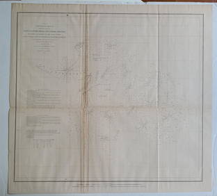
SoldSketch Showing the Progress of the Survey On The Atlantic, Gulf of Mexico and Pacific Coast Of ThePublication Date: 1870 Title: Sketch Showing the Progress of the Survey On The Atlantic, Gulf of Mexico and Pacific Coast Of The United States to November 1870 Cartographer: PIERCE, BENJAMIN PublisherSee Sold Price
Sketch Showing the Progress of the Survey On The Atlantic, Gulf of Mexico and Pacific Coast Of ThePublication Date: 1866 Title: Sketch Showing the Progress of the Survey On The Atlantic, Gulf of Mexico and Pacific Coast Of The U.S. to Nov. 1866 Cartographer: BACHE, A.D. Publisher: U.S. COAST SURVESee Sold Price
Sketch Showing the Progress of the Survey in SectionTitle: Sketch Showing the Progress of the Survey in Section No.VI (Lower Sheet) from Key West to Cape Romano ... June 30, 1889 Publication Date: 1889 Cartographer: U.S. COAST AND GEODETIC SURVEY PubliSee Sold Price
Sketch Showing the Progress of the Survey On ThePublication Date: 1861 Title: Sketch Showing the Progress of the Survey On The Atlantic, Gulf of Mexico and Pacific Coast Of The United States Of November 1860 Cartographer: U.S. COAST SURVEY PublisheSee Sold Price
Sketch Showing the Progress of the Survey in SectionTitle/Content of Map: Sketch Showing the Progress of the Survey in Section No.Xi (Upper Sheet) from Tillamook Bay to The Boundary ... June 30, 1889 Date: 1889 Cartographer: U.S. COAST SURVEY Size: 28HSee Sold Price
Sketch Showing the Progress of the Survey On The Atlantic, Gulf of Mexico and Pacific Coast Of ThePublication Date: 1865 Title: Sketch Showing the Progress of the Survey On The Atlantic, Gulf of Mexico and Pacific Coast Of The U.S. to Nov. 1865 Cartographer: BACHE, A.D. Publisher: U.S. COAST SURVESee Sold Price
Sketch Showing the Progress of the Survey in SectionTitle: Sketch Showing the Progress of the Survey in Section No.X (Middle Sheet) from Pt. Sal to Tomales Bay Publication Date: 1889 Cartographer: U.S. COAST AND GEODETIC SURVEY Publisher: U.S. C. & G.SSee Sold Price
PROTECTED BY THE WILLIAM J. BURNS DETECTIVE AGENCY PORCELAIN SIGN.Dan Morphy Auctions4.2(1.3k)See Sold PriceFeb 25, 2024
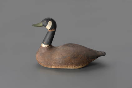
Canada Goose Decoy by J. N. Dodge Factory (1883-1893)Copley Fine Art Auctions4.5(40)See Sold PriceFeb 24, 2024
BOTH TITLE PAGES OF COLLINS" COASTAL SURVEY, 1776, IN MATCHING FRAMESThomaston Place Auction Galleries4.4(393)See Sold PriceFeb 24, 2024
Archaeological Books - J. Starkie Gardner - Victoria and Albert & South Kensington Museums ArtTimeLine Auctions Ltd.4.6(183)See Sold PriceMar 06, 2024
Large Group of Jack McLeod Original Editorial Cartoon ArtworkDana J. Tharp Auctions4.7(271)See Sold PriceFeb 24, 2024
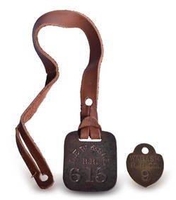
Lake Erie, Wabash & St. Louis Railroad Brass Baggage Tag and Wabash Check TagRail & Road Auctions4.6(165)See Sold PriceMar 07, 2024
Ten Pieces of Illinois Central Railroad China Coral Coffee Cups, Saucers, Bowls, Plates, BouillonRail & Road Auctions4.6(165)See Sold PriceMar 07, 2024
1863 and 1869 Lackawanna & Bloomsburg Railroad Annual PassesRail & Road Auctions4.6(165)See Sold PriceMar 08, 2024
[ENSLAVEMENT & ABOLITION]. 3 works related to enslavement, comprising:Freeman's | Hindman4.4(1.6k)See Sold PriceFeb 27, 2024
[BUFFALO SOLDIERS]. 2 photographs of "Buffalo Soldiers," Company D, 24th US Infantry, one creditedFreeman's | Hindman4.4(1.6k)See Sold PriceFeb 27, 2024
Book: A Survey of the Cities of London and Westminster, Borough of Southwark and Parts Adjacent,Claydon Auctioneers Ltd4.3(125)See Sold PriceFeb 26, 2024
1852 CHART SHOWING POSITIONS of DAVIS'S SOUTH SHOAL & OTHER DANGERS antiqueJasper524.5(9.9k)See Sold PriceFeb 27, 2024
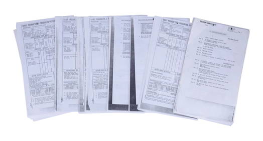
STAR WARS: THE EMPIRE STRIKES BACK (1980) - Collection of 217 Production Progress ReportsPropstore4.2(6)See Sold PriceMar 13, 2024
Senator Eugene J. McCarthy campaign bookletBaker's Antiques and Auctions3.2(471)See Sold PriceFeb 29, 2024
George IV silver toddy ladle, plus a baleen handle punch ladle & a silver spout. (3).Fellows4.3(159)See Sold PriceMar 06, 2024


![[ENSLAVEMENT & ABOLITION]. 3 works related to enslavement, comprising: (1 of 4)](https://p1.liveauctioneers.com/197/319238/171468080_1_x.jpg?height=282&quality=70&version=1707520367)
![[BUFFALO SOLDIERS]. 2 photographs of "Buffalo Soldiers," Company D, 24th US Infantry, one credited (1 of 2)](https://p1.liveauctioneers.com/197/319238/171468131_1_x.jpg?height=282&quality=70&version=1707520367)