ATLAS of ANTIENT GEOGRAPHY by SAMUEL BUTLER 1843John McInnis Auctioneers,LLC4.5(505)See Sold PriceFeb 24, 2024
18TH C. ANTIQUE MAP: FRENCH & INDIAN WAR, FRAMEDThomaston Place Auction Galleries4.4(393)See Sold PriceFeb 24, 2024
Rand McNally Railroad Map Cabinet w/ 21 Railroad MapsRail & Road Auctions4.6(165)See Sold PriceMar 08, 2024
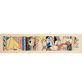
Keith Haring - Ink on New York Map, Best Buddies, Inscribed, Signed, and DatedSapphire Auction Gallery4.1(67)See Sold PriceMar 02, 2024
LATE 17TH C. FRENCH MAP OF THE NEW WORLD BY ALEXIS-HUBERT JAILLOT (1632-1712)Thomaston Place Auction Galleries4.4(393)See Sold PriceFeb 24, 2024
Central Railroad of New Jersey Map of Sandy Hook Route-ca. 1903JM Hobby Supply and Railroad Artifact Auctions4.4(127)See Sold PriceFeb 24, 2024
Lot of Six Mixed Atlas Box Cars-HO Scale-New in BoxJM Hobby Supply and Railroad Artifact Auctions4.4(127)See Sold PriceFeb 25, 2024
Rand McNally/Santa Fe Railroad Map of Iowa-1912JM Hobby Supply and Railroad Artifact Auctions4.4(127)See Sold PriceFeb 24, 2024
NICOLAES VISSCHER (NETHERLANDS, 1618-1709) MAP OF THE NEW WORLDThomaston Place Auction Galleries4.4(393)See Sold PriceFeb 24, 2024
17TH C. WORLD MAP BY NICOLAES VISSCHER (NETHERLANDS, 1618-1709)Thomaston Place Auction Galleries4.4(393)See Sold PriceFeb 24, 2024
Lot of Six Mixed Atlas Cabooses-HO Scale-New in BoxJM Hobby Supply and Railroad Artifact Auctions4.4(127)See Sold PriceFeb 25, 2024
Sketch H Showing the Progress of Section No.8.Title: Sketch H Showing the Progress of Section No.8. Publication Date: 1850 Cartographer: U.S. COAST SURVEY Publisher: U.S. C. S. [GULF COAST ALABAMA MISSISSIPPI] Height: 8.75 Width: 11.5 "from 1846See Sold Price
SoldHand-Colored Lithograph Map of the Gulf of MexicoImpressive Hand-Colored Lithograph Map of the Gulf of Mexico, titled "U.S. Coast Survey, A.D. Bache Superintendent, Sketch H, Showing the Progress of the Survey in Section No. 8, 1846-1854", the map iSee Sold Price
SoldSketch C Showing the Progress of Section No.III fromPublication Date: 1861 Title: Sketch C Showing the Progress of Section No.III from 1843 to 1860 Cartographer: U.S. COAST SURVEY Publisher: GPO Height: 34.25 Width: 22.75 Triangulation of Chesapeake BaSee Sold Price
Sketch B Showing the Progress in Section No. 2Title/Content of Map: Sketch B Showing the Progress in Section No. 2 U.S.Coast Survey 1844 to 1850 [Long Island And New Jersey Shore] Cartographer: U.S. COAST SURVEY Date: 1851 Publisher: U.S. COAST SSee Sold Price
Sketch G Showing the Progress in Section No.9 [VicinityPublication Date: 1848 Title: Sketch G Showing the Progress in Section No.9 [Vicinity of Galveston] Cartographer: U.S. COAST SURVEY Publisher: U.S. C. S. Height: 9.75 Width: 7.6 Shows triangulation. RSee Sold Price
Sketch E Showing the Progress of Section No.V ...Title/Content of Map: Sketch E Showing the Progress of Section No.V ... 1847-51 Cartographer: U.S. COAST SURVEY Date: 1853 Publisher: U.S. COAST SURVEY Size: 11.1Height - 10.6Width "Reconnaissance ofSee Sold Price
Sketch F Showing the Progress of Section No.VI ... inTitle/Content of Map: Sketch F Showing the Progress of Section No.VI ... in 1849 Cartographer: U.S. COAST SURVEY Date: 1850 Publisher: U.S. COAST SURVEY Size: 11.75Height - 18.5Width "Reconnaissance oSee Sold Price
Sketch G Showing the Progress in Section No. 9Publication Date: 1848 Title: Sketch G Showing the Progress in Section No. 9 [Galveston Bay] Cartographer: U.S. COAST SURVEY Publisher: U.S. COAST SURVEY Height: 8.25 Width: 6 "U.S. Coast Survey in 18See Sold Price
Sketch I Showing the Progress in Section No.IX fromTitle/Content of Map: Sketch I Showing the Progress in Section No.IX from 1848 to 1871 Publication Date: 1875 Cartographer: U.S. COAST SURVEY Publisher: GPO Description: Shows triangulation from GalveSee Sold Price
Sketch D Showing the Progress of Section IV 1845 toTitle: Sketch D Showing the Progress of Section IV 1845 to 1855 [Cape Henry to Cape Fear] Publication Date: 1855 Cartographer: U.S. COAST SURVEY Publisher: U.S.C.S. Size: 34.25 x 24.75 TriangulationsSee Sold Price
Sketch I Showing the Progress in Section No.9 [VicinityPublication Date: 1849 Title: Sketch I Showing the Progress in Section No.9 [Vicinity of Galveston] Cartographer: U.S. COAST SURVEY Publisher: U.S. C. S. Height: 9.75 Width: 8.6 Shows triangulation ofSee Sold Price
Sketch E Showing the Progress of Section No.V ... 1847Title: Sketch E Showing the Progress of Section No.V ... 1847 to 1860 Cartographer: U.S. Coast Survey Publisher: GPO Size: 22 X 35.5 Bull's Island to Savannah River, South Carolina and Georgia coast,See Sold Price
Sketch F Showing the Progress in Section No. VI (LowerTitle/Content of Map: Sketch F Showing the Progress in Section No. VI (Lower Sheet) from Cape Florida to Tortugas Islands Date: 1863 Cartographer: U.S. COAST SURVEY Size: 24 X 34 "from 1845 to 1863" TSee Sold Price
SoldSketch G Showing the Progress in Section No. 7 ...Title: Sketch G Showing the Progress in Section No. 7 ... Date: 1850 Cartographer: U.S. COAST SURVEY Publisher: U.S. COAST SURVEY Description: in the year 1849 reconnoissance of Pensacola and PerdidoSee Sold Price
Sketch C. Showing the Progress of Section No.3 U.S.Title: Sketch C. Showing the Progress of Section No.3 U.S. Coast Survey 1844 to 1850 [Chesapeake and Delaware Bays] Publication Date: 1850 Cartographer: U.S. COAST SURVEY Publisher: U.S. C. S. Height:See Sold Price
Sketch C. Showing the Progress of Section No.3 ... 1844Title/Content of Map: Sketch C. Showing the Progress of Section No.3 ... 1844 to 1850. Cartographer: U.S. COAST SURVEY Date: 1850 Publisher: U.S. COAST SURVEY Size: 21.75Height - 16Width Region aroundSee Sold Price
SoldSketch I Showing the Progress in Section No.Ix fromTitle: Sketch I Showing the Progress in Section No.Ix from 1848 to 1866 [Vicinity of Galveston] Cartographer: U.S. COAST SURVEY Publisher: GPO Size: 10 X 25 Shows triangulation of Galveston Bay. A litSee Sold Price
Sketch F Showing the Progress in Section No. VI ...Title: Sketch F Showing the Progress in Section No. VI ... 1849 & '50 [General Florida Reef and the Keys] Publication Date: 1850 Cartographer: U.S. COAST SURVEY Publisher: U.S. COAST SURVEY Size: 12.5See Sold Price
SoldChart of Outer Banks, 1853 U. S. Coast SurveyReserve Reduced! Hand-colored chart of the Outer Banks on the east coast of North Carolina and Virginia. “Sketch D Showing the Progress of Section IV, 1845-1853.” Area shown includes Albemarle SouSee Sold Price
SoldChart of Outer Banks, 1853 U. S. Coast SurveyHand-colored chart of the Outer Banks on the east coast of North Carolina and Virginia. “Sketch D Showing the Progress of Section IV, 1845-1853.” Area shown includes Albemarle Sound, Pamlico SoundSee Sold Price
SoldU.S. Coast Survey 1853 Map of Long Island, New Jersey"Sketch B Showing the progress of Section No. 2" Electrotype Map Published 1843-65, Washington for "Report of the Superintendent of the U.S. Coast Survey..." Published under the supervision and directSee Sold Price
SoldTwo 19th Century North Carolina Coastal MapsTwo 19th Century North Carolina Coastal Mapsas follows: Sketch D Showing the progress of Section No 4 U. S. Coast Survey in 1846-47 & 48 (Washington, 1849), steel engraving of Albemarle Sound with hanSee Sold Price
Sketch Showing the Progress of the Survey in SectionTitle: Sketch Showing the Progress of the Survey in Section No.VI (Lower Sheet) from Key West to Cape Romano ... June 30, 1889 Publication Date: 1889 Cartographer: U.S. COAST AND GEODETIC SURVEY PubliSee Sold Price
Sketch Showing the Progress of the Survey in SectionTitle/Content of Map: Sketch Showing the Progress of the Survey in Section No.Xi (Upper Sheet) from Tillamook Bay to The Boundary ... June 30, 1889 Date: 1889 Cartographer: U.S. COAST SURVEY Size: 28HSee Sold Price
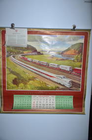
1954 Pennsylvania Railroad Calendar-Pittsburgh Promotes ProgressJM Hobby Supply and Railroad Artifact Auctions4.4(127)See Sold PriceFeb 24, 2024
1956 Pennsylvania Railroad Calendar-Dynamic ProgressJM Hobby Supply and Railroad Artifact Auctions4.4(127)See Sold PriceFeb 24, 2024
BOWSER MODEL #C 81 H "SQUARE VISIBLE" GAS PUMP.Dan Morphy Auctions4.2(1.3k)See Sold PriceFeb 24, 2024
WILLIAM HENRY DETHLEF KOERNER (NJ/NY/MT, 1878-1938)Thomaston Place Auction Galleries4.4(393)See Sold PriceFeb 25, 2024
Parker Vacuum Filler Demonstrator Fountain PenNorth American Pen Auctions LTD4.4(12)See Sold PriceFeb 24, 2024
Vintage County Map Of NY State Plate EngravingThe Benefit Shop Foundation Inc.4.3(2.9k)See Sold PriceFeb 28, 2024
Antique Globe Wernicke 5 stack Barrister Bookcase in the mahogany finishSouth Jersey Auction by Babington Auction Inc4.6(124)See Sold PriceFeb 25, 2024
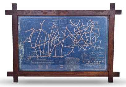
New York, New Haven and Hartford Railroad Framed Car Clearance Blue Prints Revised 1935Rail & Road Auctions4.6(165)See Sold PriceMar 08, 2024
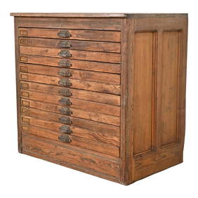
Antique Pine 12-Drawer Blueprint Flat File Cabinet by Hamilton, Circa 1900Liberty & 33rd Furniture Co.4.4(13)See Sold PriceFeb 27, 2024
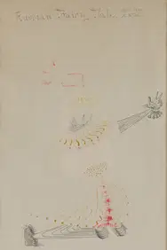
George Valentine Dureau (American/Louisiana, 1930-2014), "Five Figurative Sketches," H.- 18 in., W.-Crescent City Auction Gallery4.3(231)See Sold PriceMar 08, 2024
H. Alken / Fore's Hunting Sketches (Plates 1 to 6)Keystone Auction LLC4.6(934)See Sold PriceMar 01, 2024
18TH C. CHIPPENDALE WALNUT CARVED CHEST ON CHEST.William Smith Auctions4.6(147)See Sold PriceMar 06, 2024
19TH C. BIRDSEYE MAPLE CHEST, TWITCHELL FARM, ME.William Smith Auctions4.6(147)See Sold PriceMar 06, 2024