ATLAS of ANTIENT GEOGRAPHY by SAMUEL BUTLER 1843John McInnis Auctioneers,LLC4.5(505)See Sold PriceFeb 24, 2024
18TH C. ANTIQUE MAP: FRENCH & INDIAN WAR, FRAMEDThomaston Place Auction Galleries4.4(393)See Sold PriceFeb 24, 2024
Rand McNally Railroad Map Cabinet w/ 21 Railroad MapsRail & Road Auctions4.6(165)See Sold PriceMar 08, 2024
Keith Haring - Ink on New York Map, Best Buddies, Inscribed, Signed, and DatedSapphire Auction Gallery4(67)See Sold PriceMar 02, 2024
LATE 17TH C. FRENCH MAP OF THE NEW WORLD BY ALEXIS-HUBERT JAILLOT (1632-1712)Thomaston Place Auction Galleries4.4(393)See Sold PriceFeb 24, 2024
Central Railroad of New Jersey Map of Sandy Hook Route-ca. 1903JM Hobby Supply and Railroad Artifact Auctions4.4(127)See Sold PriceFeb 24, 2024
Lot of Six Mixed Atlas Box Cars-HO Scale-New in BoxJM Hobby Supply and Railroad Artifact Auctions4.4(127)See Sold PriceFeb 25, 2024
Rand McNally/Santa Fe Railroad Map of Iowa-1912JM Hobby Supply and Railroad Artifact Auctions4.4(127)See Sold PriceFeb 24, 2024
NICOLAES VISSCHER (NETHERLANDS, 1618-1709) MAP OF THE NEW WORLDThomaston Place Auction Galleries4.4(393)See Sold PriceFeb 24, 2024
17TH C. WORLD MAP BY NICOLAES VISSCHER (NETHERLANDS, 1618-1709)Thomaston Place Auction Galleries4.4(393)See Sold PriceFeb 24, 2024
Lot of Six Mixed Atlas Cabooses-HO Scale-New in BoxJM Hobby Supply and Railroad Artifact Auctions4.4(127)See Sold PriceFeb 25, 2024
SoldSEUTTER, MATTHIAS, MAP OF NEW FRANCE, 1750Seutter, Matthias PARTIE ORIENTALE DE LA NOUVELLE FRANCE ON DU CANADA AVEC L’ISLE DE TERRE-NEUVE ET DE NOUVELLE ESCOSSE ACADIE ET NOUV-ANGLETERRE AVEC FLEUVE DE ST. LAURENCE Augsbourg, [1750] H. 59.See Sold Price
SoldRare Colonial New Ebenezer Settlement Georgia MapRare Colonial Georgia Map of the New Ebenezer Settlement [Plan Von Neu Ebenezer...] hand-colored engraving by Matthias Seutter (German, 1678-1757), for Samuel Urlsperger's Ausfuhrliche Nachtricht vonSee Sold Price
SEUTTER, Matthias (editore; 1678-1757) - Atlas MinorSEUTTER, Matthias (editore; 1678-1757) - Atlas Minor praecipua Orbis terrarium Imperia, Regna et Provincias Germania. Habsburg: [c. 1750]. Copy complete of all the plates handcoloured in a contemporarSee Sold Price
SoldMap after Johann Homann, Asiaun-colored copperplate engraving, (Augsburg: Matthias Seutter, n.d., circa 1750), depicts the entirety of Asia. Two decorative vignettes. Presented behind mat in a gilt wooden frame. SS 19.5 x 22.75 iSee Sold Price
Sold(Maps and Charts, North America), Seutter, Albrec(Maps and Charts, North America), Seutter, Albrecht Karl, Partie orientale de la nouvelle France ou du Canada, Augsburg: Matthaeus Seutter, [1750 or later], hand-colored, sight size 611 x 520 mm, (cenSee Sold Price
SoldSEUTTER - 1750 KINGDOM OF MERCIE FRENCH MAPMatthieu / Matthaus Seutter 1678-1757 - Circa 1750 Kingdom of Mercie Topographical Map. Latin Text La Pius Grande Partie de la Manche, qui contient Les Cotes d'Angleterre et celles de France les bordsSee Sold Price
Sold1730 Original Seutter Map New England, NYOriginal 1730 hand-colored map in Latin and Dutch "Recens edita totius Novi Belgii in America Septentrionali," by Matthew Sutter (German), illustrating the north-eastern region of what is now the UnitSee Sold Price
Reiner Ottens American Heritage Map of New FranceMap: Map entitled "New France 1745 drawn by Reiner Ottens". Maker: Reiner Ottens Publisher: American Heritage Size: approximately 24 inches high x 18 inches wide It’s a reproduction by American HeriSee Sold Price
Soldde Vaugondy: Antique Map of New France & Great LakesMap: Partie de l'Amerique Septent. qui comprend la Nouvelle France ou le Canada Cartographer: Robert de Vaugondy Place & Date: Paris / 1755 Size: 23 5/8" x 19" Condition: outline color; some water staSee Sold Price
SoldChamplain's Map of New France 1632.Reserve Reduced! Title: Champlain's Map of New France 1632. Publication Date: 1850 Cartographer: CHAMPLAIN, SAMUEL DE sieur/DAVID VAUGHN/AUGUSTUS TOLLE Publisher: WEED, PARSONS & CO. Size: 10.25 X 17.See Sold Price
SoldCarte De La Nouvelle France (Map of New France)Carte De La Nouvelle France (Map of New France / Canada). Framed Size: 24 1/2" x 22". Fine full color example of Henri Chatelain's map of the inhabited parts of North America, based upon Nicholas De FSee Sold Price
Sold1730 Seutter Map of New England to Virginia -- RecensTitle/Content of Map: 1730 Seutter Map of New England to Virginia -- Recens Edita totius Novi Belgii, in America Septentrionali siti, delineatio cura et Sumtibus Date: 1730, Nurnberg Cartographer: M SSee Sold Price
Sold1730 Seutter Map of New England to Virginia -- RecensTitle: 1730 Seutter Map of New England to Virginia -- Recens Edita totius Novi Belgii, in America Septentrionali siti, delineatio cura et Sumtibus Date: 1730, Nurnberg Cartographer: M Seutter Size: 19See Sold Price
SoldMOLL, HERMAN. A Map of New France Containing Canada,MOLL, HERMAN. A Map of New France Containing Canada, Louisiana &c. in Nth America. Hand-colored engraved map of colonial North America. 7¾x10¾ inches sheet size, ample margins; mounted to foSee Sold Price
1730 Seutter Map of New England to Virginia -- RecensReserve Reduced! Title/Content of Map: 1730 Seutter Map of New England to Virginia -- Recens Edita totius Novi Belgii, in America Septentrionali siti, delineatio cura et Sumtibus Date: 1730, NurnbergSee Sold Price
1730 Seutter Map of New England to Virginia -- RecensTitle/Content of Map: 1730 Seutter Map of New England to Virginia -- Recens Edita totius Novi Belgii, in America Septentrionali siti, delineatio cura et Sumtibus Date: 1730, Nurnberg Cartographer: M SSee Sold Price
1730 Seutter Map of New England to Virginia -- RecensTitle/Content of Map: 1730 Seutter Map of New England to Virginia -- Recens Edita totius Novi Belgii, in America Septentrionali siti, delineatio cura et Sumtibus Date: 1730, Nurnberg Cartographer: M SSee Sold Price
1730 Seutter Map of New England to Virginia -- RecensTitle/Content of Map: 1730 Seutter Map of New England to Virginia -- Recens Edita totius Novi Belgii, in America Septentrionali siti, delineatio cura et Sumtibus Date Printed: 1730, Nurnberg CartograpSee Sold Price
1730 Seutter Map of New England to Virginia -- RecensTitle/Content of Map: 1730 Seutter Map of New England to Virginia -- Recens Edita totius Novi Belgii, in America Septentrionali siti, delineatio cura et Sumtibus Date Printed: 1730, Nurnberg CartograpSee Sold Price
SoldCouagne Manuscript Map of New France / CanadaCOUAGNE, Jean-Baptiste de (1687-1740). Nouvelle France. Exceptionally fine original manuscript map of "New France", in pen and ink with green color wash (central vertical crease).Canada, c. 1711. 19"See Sold Price
SoldChamplains Definitive Map of New FranceCarte de la nouvelle France from Les Voyages de la Novvelle France Occidentale, dicte Canada . Samuel de Champlain (c. 1567 - 1635). Copper-plate engraving on two sheets. Paris: 1632. 20 1/2 x 34 inchSee Sold Price
SoldH.A. CHATELAIN: Antique Map of New FranceChatelain, Henri Abraham "Carte de la Nouvelle France" ( "A Map of New France")1719 Copperplate engraving. Lower Loisiana is colored yellow, the pink area represents Canadian territory, the green BritSee Sold Price
SoldMatthaus Seutter Map of France 1740Matthaus Seutter, Map of France, 1740. Titled "Provincia Gallis La Provence dicta". Measures 24-1/8" x 20.5" sheet size. Unframed, loose and not glued or mounted. Provenance: C.D. Raymond & Son collecSee Sold Price
Crams Township and Railroad Map of New York-1890JM Hobby Supply and Railroad Artifact Auctions4.4(127)See Sold PriceFeb 24, 2024
LARGE LATE 17TH C. DUTCH CHART OF CANADA, GREAT LAKES, NEW FRANCE, LABRADOR, HUDSON BAY, BY PIERREThomaston Place Auction Galleries4.4(393)See Sold PriceFeb 24, 2024
Vintage County Map Of NY State Plate EngravingThe Benefit Shop Foundation Inc.4.3(2.9k)See Sold PriceFeb 28, 2024
[MAP]. [ALBRIZZI, Giambatista, 1698-1777]. Carta Geografica...Potter & Potter Auctions4.6(545)See Sold PriceMar 07, 2024
D'Entrecasteaux - Australia: Coasts of Van Diemen's Land (New Holland). 9Trillium Antique Prints & Rare Books4.5(32)See Sold PriceFeb 24, 2024
D'Entrecasteaux - Australia: Chart of Van Diemen's Land (New Holland). 3Trillium Antique Prints & Rare Books4.5(32)See Sold PriceFeb 24, 2024
D'Entrecasteaux - Map of Australia (New Holland), New Zealand, and southern Asia and surroundingTrillium Antique Prints & Rare Books4.5(32)See Sold PriceFeb 24, 2024
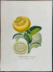
Risso - Lemon or Citrus Fruit. 73Trillium Antique Prints & Rare Books4.5(32)See Sold PriceFeb 24, 2024
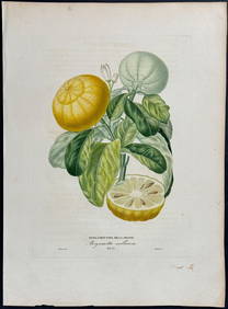
Risso - Lemon or Citrus Fruit. 71Trillium Antique Prints & Rare Books4.5(32)See Sold PriceFeb 24, 2024
1750 Bowen Map of Bermuda and St. Kitts -- A New & Accurate Map of Bermudas or Sommer's Islands...Jasper524.5(9.9k)See Sold PriceFeb 27, 2024
Robert Benard (1734 - 1777) - Set of 9 Copperplate Engravings - Greek and Roman architecture - ViewProverde Auctions4.3(3)See Sold PriceFeb 28, 2024
Robert Benard (1734 - 1777) - Set of 9 Copperplate Engravings - Architecture, Masonry, Quarry withProverde Auctions4.3(3)See Sold PriceFeb 28, 2024
Robert Benard (1734 - 1777) - Set of 9 Chemical Engravings - Alchemical symbols - Utensils forProverde Auctions4.3(3)See Sold PriceFeb 28, 2024
Jules Verne, De La Terre a La Lune, Au Steamer Red MacaronLion and Unicorn4.8(1.9k)See Sold PriceMar 10, 2024
Jules Verne, L'Archipel en Feu, Au Steamer Red MacaronLion and Unicorn4.8(1.9k)See Sold PriceMar 10, 2024
Herman Moll A New Map of Ye North Parts of AmericaWillow Auction House4.5(289)See Sold PriceMar 14, 2024


![[MAP]. [ALBRIZZI, Giambatista, 1698-1777]. Carta Geografica... (1 of 1)](https://p1.liveauctioneers.com/928/318880/171361280_1_x.jpg?height=282&quality=70&version=1707501302)