2 Illuminated Books of Hours LeavesSchmidt's Antiques Inc. Since 19114.8(431)See Sold PriceMar 02, 2024
Illuminated Manuscript Leaf of The CrucifixionSchmidt's Antiques Inc. Since 19114.8(431)See Sold PriceMar 02, 2024
RARE 1930s AUTOGRAPH BOOK FEATURING RUTH & GEHRIGJohn McInnis Auctioneers,LLC4.6(502)See Sold PriceFeb 25, 2024
Timetable, Paper and Ephemera Lot-Eastern USA RailroadsJM Hobby Supply and Railroad Artifact Auctions4.4(126)See Sold PriceFeb 24, 2024
SCARCE 1971 Kim Il Sung Signed Book "ON THE WORK OF THE WOMAN'S UNION"Rbfinearts4.4(571)See Sold PriceFeb 24, 2024
1885 CIVIL WAR 1ed Famous Memoirs US Grant Sheridan Sherman 6v RARE LOT MapsSchilb Antiquarian Rare Books4.8(421)See Sold PriceMar 10, 2024
"WINTER AND SUMMER IN MAINE" 1904 PHOTO ALBUMJohn McInnis Auctioneers,LLC4.6(502)See Sold PriceFeb 25, 2024
1821 THE (3) VOYAGES of CAPT JAMES COOK VOL. I-VIIJohn McInnis Auctioneers,LLC4.6(502)See Sold PriceFeb 24, 2024
[BASEBALL]. [SHEET MUSIC]. KALBFLEISCH, J. H. The Live Oak ...Potter & Potter Auctions4.6(539)See Sold PriceMar 07, 2024
Illuminated Manuscript Leaf of The VisitationSchmidt's Antiques Inc. Since 19114.8(431)See Sold PriceMar 02, 2024
Illuminated Manuscript Leaf of GethsemaneSchmidt's Antiques Inc. Since 19114.8(431)See Sold PriceMar 02, 2024
c1700s RARE Arabic Handwritten Manuscript Middle East Persia Journal ARABIASchilb Antiquarian Rare Books4.8(421)See Sold PriceMar 10, 2024
SoldCouagne Manuscript Map of New France / CanadaCOUAGNE, Jean-Baptiste de (1687-1740). Nouvelle France. Exceptionally fine original manuscript map of "New France", in pen and ink with green color wash (central vertical crease).Canada, c. 1711. 19"See Sold Price
SoldCarte De La Nouvelle France (Map of New France)Carte De La Nouvelle France (Map of New France / Canada). Framed Size: 24 1/2" x 22". Fine full color example of Henri Chatelain's map of the inhabited parts of North America, based upon Nicholas De FSee Sold Price
SoldMOLL, HERMAN. A Map of New France Containing Canada,MOLL, HERMAN. A Map of New France Containing Canada, Louisiana &c. in Nth America. Hand-colored engraved map of colonial North America. 7¾x10¾ inches sheet size, ample margins; mounted to foSee Sold Price
SoldHerman Moll Map of New France, 1717Herman Moll, "A Map of New France Containing Canada, Louisiana...in Nth. America", London, 1717; and "New England, New York, New Jersey and Pensilvania", London, 1729, known as the "Postal Map"; bothSee Sold Price
SoldAFTER JEAN COVENS 1730 MAP OF CANADA NEW FRANCE(20th c) 14 x 16 1/2 inches. framed 24 x 26 1/2 inches (overall)See Sold Price
SoldNicolas de Fer: Map of Canada & New France, 1702Map: Nicolas de Fer's Map of Canada and New France Subtitle: La Canada, ou Nouvelle France, la Floride, la Virginie, Pensilvanie, Caroline, Nouvelle Angleterre et Nouvelle Yorck, Isle de Terre Neuve,See Sold Price
SoldBoisseau Map of Canada / New FranceBOISSEAU, Jean (fl. 1631-1657). Description de la Nouvelle France... Engraved map with original hand color. Paris, 1643. 14 1/2" x 21 3/4" visible, 21" x 29" framed. This rare map is, in fact, the firSee Sold Price
Sold(MANUSCRIPT SCHOOL MAP.) Lamb, Frances H. New York.(MANUSCRIPT SCHOOL MAP.) Lamb, Frances H. New York. Manuscript map in ink and watercolor on wove paper. 16¾x21½ inches sheet size; mounted to board stabilizing several large tears, other smaSee Sold Price
Sold18th C. Hand-Colored Map of New EnglandAn 18th C. hand-colored engraved map of New England, Nova Scotia, New France, or Canada, with the Islands of Newfoundland, Cape Breton, St. John's, by Jacques-Nicholas Bellin. Framed under glass. MatSee Sold Price
"La parte Occidentale della Nuova Francia o Canada". QCTITLE/CONTENT OF MAP: 'La parte Occidentale della Nuova Francia o Canada' "The western part of New France or Canada". The map shows part of western Quebec and north eastern Ontario between James Bay,See Sold Price
La parte Occidentale della Nuova Francia o Canada. QCReserve Reduced! TITLE/CONTENT OF MAP: 'La parte Occidentale della Nuova Francia o Canada' "The western part of New France or Canada". The map shows part of western Quebec and north eastern Ontario beSee Sold Price
La parte Occidentale della Nuova Francia o Canada. QCReserve Reduced! TITLE/CONTENT OF MAP: 'La parte Occidentale della Nuova Francia o Canada' "The western part of New France or Canada". The map shows part of western Quebec and north eastern Ontario beSee Sold Price
La parte Occidentale della Nuova Francia o Canada. QCTITLE/CONTENT OF MAP: 'La parte Occidentale della Nuova Francia o Canada' "The western part of New France or Canada". The map shows part of western Quebec and north eastern Ontario between James Bay,See Sold Price
Sold1746 Leather Volume Map New England English Rebellion1746 Volume , featuring large folding “New Chart of the Coast of New England Nova Scotia, New France or Canada…”, of Gentleman’s Magazine for the year 1746 containing all twelve issues and SupSee Sold Price
SoldBellin/Jefferys: Antique Map of Canada & Islands, 1746Map: A new chart of the coast of New England, Nova Scotia, New France or Canada, with the islands of Newfoundl’d. Cape Breton, St. John’s &c. Publication Date: 1746 Authors: Gentleman’s MagazineSee Sold Price
SoldGrp: 4 Maps of Canada w/ 1 Map of the Indian OceaGroup of four maps of Canada, including "The River St. Lawrence accurately drawn from d'Anville's Map," London: John Harrison, ca. 1780; New York State Library, "Champlain's Map of New France 1632," NSee Sold Price
SoldSEUTTER, MATTHIAS, MAP OF NEW FRANCE, 1750Seutter, Matthias PARTIE ORIENTALE DE LA NOUVELLE FRANCE ON DU CANADA AVEC L’ISLE DE TERRE-NEUVE ET DE NOUVELLE ESCOSSE ACADIE ET NOUV-ANGLETERRE AVEC FLEUVE DE ST. LAURENCE Augsbourg, [1750] H. 59.See Sold Price
1746 Map of New England Canada Gentleman's Magazine1746 Volume, featuring large folding "New Chart of the Coast of New England Nova Scotia, New France or Canada", of Gentleman's Magazine for the year 1746 containing all twelve issues and Supplement. ESee Sold Price
SoldChamplains Definitive Map of New FranceCarte de la nouvelle France from Les Voyages de la Novvelle France Occidentale, dicte Canada . Samuel de Champlain (c. 1567 - 1635). Copper-plate engraving on two sheets. Paris: 1632. 20 1/2 x 34 inchSee Sold Price
SoldLescarbot Map of New FranceFigure De La Terre, Neuve, Grande Riviere De Canada, Et Côtes De L’Ocean En La Nouvelle France. Marc Lescarbot (1570-1641). Copper-plate engraving. Paris, 1609. 7 3/4 x 17 1/2 inches. This is the 1See Sold Price
SoldSanson Map of New FranceSanson d'Abbeville, Nicholas (1600-1667). Le Canada, ou Nouvelle France. Engraved map with original hand color. Paris: Pierre Mariette, 1656. 16" x 21 1/2" sheet, 19" x 25" framed. The First Map of CaSee Sold Price
Roggeveen Map of New France, 1675ROGGEVEEN, Arent (1628-1679). Pascaerte van Terra Nova Nova Francia Nievw Engeland En de Groote Revier van Canada. Engraved map with original hand color from Het Brandende Veen. Amsterdam, 1675 (StateSee Sold Price
Santini/d'Anville: Antique Map of "New France", 1784TITLE/CONTENT OF MAP: 'Partie Orientale du Canada avec la Nouvelle Angleterre, l'Acadie, et la Terre-Neuve. Par le S. d'Anville. À Venise par P. Santini 1776 [Eastern Canada with New England, Acadia,See Sold Price
The Coast of New England, Nova Scotia, New France or Canada. GENTS MAG 1746 mapTitle: The Coast of New England, Nova Scotia, New France or Canada. GENTS MAG 1746 map Description: A New Chart of the Coast of New England, Nova Scotia, New France or Canada with the Islands of NewfoSee Sold Price
LARGE LATE 17TH C. DUTCH CHART OF CANADA, GREAT LAKES, NEW FRANCE, LABRADOR, HUDSON BAY, BY PIERREThomaston Place Auction Galleries4.4(386)See Sold PriceFeb 24, 2024
[MAP]. [ALBRIZZI, Giambatista, 1698-1777]. Carta Geografica...Potter & Potter Auctions4.6(539)See Sold PriceMar 07, 2024
D'Entrecasteaux - Australia: Coasts of Van Diemen's Land (New Holland). 9Trillium Antique Prints & Rare Books4.5(30)See Sold PriceFeb 24, 2024
D'Entrecasteaux - Australia: Chart of Van Diemen's Land (New Holland). 3Trillium Antique Prints & Rare Books4.5(30)See Sold PriceFeb 24, 2024
D'Entrecasteaux - Map of Australia (New Holland), New Zealand, and southern Asia and surroundingTrillium Antique Prints & Rare Books4.5(30)See Sold PriceFeb 24, 2024
South Namibia coast. Walvis Bay-Orange River ADMIRALTY sea chart 1881 (1954) mapJasper524.5(9.8k)See Sold PriceFeb 28, 2024
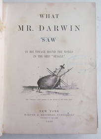
1880 WHAT MR. DARWIN SAW IN SHIP BEAGLE ANTIQUE DURING HIS WORLD TOURNY Elizabeth 4.3(84)See Sold PriceMar 03, 2024
1829 GERMAN-LANGUAGE ANTIQUE AMERICAN BIBLE ILLUSTRATED WITH MAPS OF PHILADELPHIANY Elizabeth 4.3(84)See Sold PriceMar 03, 2024
DAVOUT LOUIS NICOLAS: (1770-1823)International Autograph Auctions Europe S.L.4.5(52)See Sold PriceMar 14, 2024
2022 Canada Ag $50 Relics of New France: Louis XIV 30 Deniers SetGolden Air Auctions4.4(257)See Sold PriceFeb 25, 2024
Robert de Vaugondy - Map of Canada - Mer de l' Ouest or Sea of the West and a Northwest PassageProverde Auctions4.3(3)See Sold PriceFeb 28, 2024
Jules Verne, De La Terre a La Lune, Au Steamer Red MacaronLion and Unicorn4.7(1.8k)See Sold PriceMar 10, 2024
Jules Verne, L'Archipel en Feu, Au Steamer Red MacaronLion and Unicorn4.7(1.8k)See Sold PriceMar 10, 2024
Herman Moll A New Map of Ye North Parts of AmericaWillow Auction House4.5(283)See Sold PriceMar 14, 2024


![[BASEBALL]. [SHEET MUSIC]. KALBFLEISCH, J. H. The Live Oak ... (1 of 5)](https://p1.liveauctioneers.com/928/318880/171361400_1_x.jpg?height=282&quality=70&version=1707501302)


![[MAP]. [ALBRIZZI, Giambatista, 1698-1777]. Carta Geografica... (1 of 1)](https://p1.liveauctioneers.com/928/318880/171361280_1_x.jpg?height=282&quality=70&version=1707501302)