SoldSet of Nine Maps published by Augustus MitchellSet of Nine Maps published by Augustus Mitchell -- # 7, 14, 18, 19, 20, 22, 29, 30 & 34 - 17 7/8" x 14"See Sold Price
SoldAntique 1846 Mitchel's Wall Map of American RepublicAntique 1846 Mitchell national map of American Republic. This map was published by Samuel Augustus Mitchell in 1846 in Philadelphia. Mitchell started his working life as a teacher, but was inspired toSee Sold Price
Mitchell's New General Atlas containing maps of theTitle:Mitchell's New General Atlas containing maps of the various countries of the world, plans of cities, etc., embraced in seventy-nine quarto maps. Author: SAMUEL AUGUSTUS MITCHELL, JR Publisher/MaSee Sold Price
SoldFramed "Traveler's Map of Pennsylvania" County colored Framed "Traveler's Map of Pennsylvania" County colored map published in 1831 by Augustus Mitchell. Map is accompanied by the gold embossed leather sleeve marked as quoted above and with an 1830 PennsySee Sold Price
Sold1849 Colored Map of WisconsinAn historical colored map of Wisconsin published by S. Augustus Mitchell of Philadelphia dates from the first year of Wisconsin's statehood, 1849. It shows Native American tribal area and includes ChiSee Sold Price
1880 COUNTY MAP OF THE STATE OF ILLINOISA framed 1880 map of Illinois published by S. Augustus Mitchell and/or A. Mitchell, Jr. A notable feature of the map is the inset with the well detailed plan of Chicago and the rapidly expanding railrSee Sold Price
Sold1847 Hand-Colored Map: A New Map of VIRGINIA...Historic Maps 1847 “A New Map of Virginia...” by S. Augustus Mitchell 1847-Dated, Hand-Colored Map titled “A New Map of VIRGINIA...”, Published by S. Augustus Mitchell, Choice Crisp ExtremelySee Sold Price
Sold1847 MITCHELL MAP OF FLORIDA1847 MITCHELL MAP OF FLORIDA: Published 1847 by Augustus Mitchell, hand colored showing counties, Seminole War battles sights, forts and troop routes, 3 insets. Sight size 14 3/4" x 11 3/4", framed 21See Sold Price
SoldTOUR POCKET MAP OF MICHIGAN, PUBLISHED BY S. AUTOUR POCKET MAP OF MICHIGAN, PUBLISHED BY S. AUGUSTUS MITCHELL, 1836, 15" X 12 1/2"See Sold Price
SoldNine (9) Augustus Mitchell MapsCollection of late 19th century United States STATE maps including Minnesota, Iowa and Missouri, State of Maine , Illinois-Missouri-Iowa-Nebraska-and Kansas on one, Two Georgia and Alabama, ConnecticuSee Sold Price
SoldMitchell: Map of City of New York, 1849An original steel engraved map of New York City published by Augustus Mitchell in 1849, with original hand coloring. Manhattan from about 37th St with Brooklyn and Williamsburg. Key to public buildingSee Sold Price
SoldRARE LARGE 1831 EDITION OF MITCHELL'S MAP OF U. S.A rare large wall map by J.H. Young, published by S. Augustus Mitchell circa 1831, first edition, the large wall map with various inset maps, views, comparative tables of river lengths and mountain heSee Sold Price
1844 World MapTitle: 1844 World Map Medium: Ink on Paper Dimensions: 12"X10" World map dated 1844. Engraved and published by Augustus Mitchell in "Mitchell's Ancient Geography". This map captures the world as knownSee Sold Price
1844 Map of the United States of Columbia & VenezuelaAuthor: Mitchell Title: 1844 Map of the United States of Columbia & Venezuela Medium: Ink on paper Dimensions: 12"X10" Map dated 1844. Engraved and published by Augustus Mitchell in "Mitchell's AncienSee Sold Price
RARE LARGE 1831 EDITION OF MITCHELL'S MAP OF U. S.A rare large wall map by J.H. Young, published by S. Augustus Mitchell circa 1831, first edition, the large wall map with various inset maps, views, comparative tables of river lengths and mountain heSee Sold Price
SoldPair of 19th C Augustus Mitchell MapsDESCRIPTION: Pair of 19th century maps. The first being a map of North America published by S. Augustus Mitchell and predating the Civil War. The second a map of Pennsylvania also published by S. AuguSee Sold Price
1847 Map of the WorldAuthor: Mitchell Title: 1847 Map of the World Medium: Ink on Paper Dimensions: 12"X10" World map dated 1844. Engraved and published by Augustus Mitchell in "Mitchell's Ancient Geography". This map capSee Sold Price
1844 World MapAuthor: Mitchell Title: 1844 World Map Medium: Ink on Paper Dimensions: 12"X10" World map dated 1844. Engraved and published by Augustus Mitchell in "Mitchell's Ancient Geography". This map captures tSee Sold Price
1855 Map of EnglandAuthor: Mitchell Title: 1855 Map of England Medium: Ink on Paper Dimensions: 14"X17.5" Map of England dated 1855. Published by Augustus Mitchell in Philadelphia. Key lower middle. Insets of LiverpoolSee Sold Price
Sold1844 World MapTitle: 1844 World Map Author: Mitchell Medium: Ink on Paper Dimensions: 12"X14" Description: World map dated 1844. Engraved and published by Augustus Mitchell in "Mitchell's Ancient Geography". This mSee Sold Price
Sold1864 Map of PalestineAuthor: Mitchell Title: 1864 Map of Palestine Medium: Ink on Paper Dimensions: 12.5"X15.5" Description: Map of Palestine dated 1864. Published by Augustus Mitchell in Philadelphia. Elaborate border. CSee Sold Price
SoldNew Jersey Reduced From T. Gordon's MapNew Jersey Reduced from T. Gordon's Map by H.S. Tanner, published by S. Augustus Mitchell, N.E. corner of Market & 7th Streets, Phila. 1847. Hand colored. Has some discoloration to the edges of the paSee Sold Price
SoldPennsylvania New Jersey & Delaware 1831 Map BookPennsylvania, New Jersey, and Delaware map book. Brown leather cover with gilt. 6" x 3-1/2" (separated at spine). Map 17" x 21". Published by S. Augustus Mitchell, 1831. Handcolored, splits at folds,See Sold Price
1855 Map of EnglandAuthor: Mitchell Title: 1855 Map of England Medium: Ink on Paper Dimensions: 14"X17.5" Map of England dated 1855. Published by Augustus Mitchell in Philadelphia. Key lower middle. Insets of LiverpoolSee Sold Price
1885 CIVIL WAR 1ed Famous Memoirs US Grant Sheridan Sherman 6v RARE LOT MapsSchilb Antiquarian Rare Books4.8(428)See Sold PriceMar 10, 2024
18 Booklets Collection - War Graves of Palestine - WWILevy Auction House4.3(11)See Sold PriceFeb 27, 2024
1849 Mitchell School ATLAS 24 MAPS America Holy Land France Africa Egypt AsiaSchilb Antiquarian Rare Books4.8(428)See Sold PriceMar 31, 2024
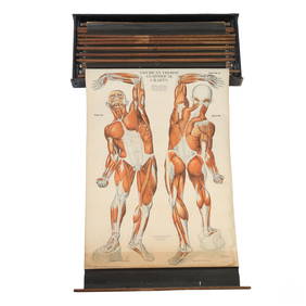
Nystrom 20C. Antique Illustrated Anatomical ChartsHill Auction Gallery 4.7(1k)See Sold PriceFeb 28, 2024
Mitchell - Map of the City of Washington (Washington, DC)Trillium Antique Prints & Rare Books4.5(32)See Sold PriceFeb 24, 2024
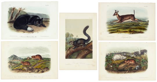
Phalangium Liliago Hand Colored Engraving Signed P.J. RedouteJasper524.5(9.9k)See Sold PriceFeb 28, 2024
Nearly complete set of plates from Vol. III Quad QuartoPBA Galleries4.7(385)See Sold PriceMar 07, 2024
Two Hand-Colored 19th Century Maps of New Orleans and Louisiana, Larger- H.- 12 1/2 in., W.- 15 1/2Crescent City Auction Gallery4.3(231)See Sold PriceMar 08, 2024
Camille Flammarion (1842 - 1925) - Set of 20 Astronomical Prints - Different colors of the moonProverde Auctions4.3(3)See Sold PriceFeb 28, 2024
Charles Antoine Lemaire (1800 - 1871) - Set of 4 Botanical Prints - Rose - Camellia Duchesse deProverde Auctions4.3(3)See Sold PriceFeb 28, 2024
Carl Axel Magnus Lindman (1856 - 1928) - Set of 10 Botanical Prints - Consolida regalis - CampanulaProverde Auctions4.3(3)See Sold PriceFeb 28, 2024
Henri Plon - Set of 10 Prints - Ethnography - Pekin - Japan - Anthropologic LithographyProverde Auctions4.3(3)See Sold PriceFeb 28, 2024