ATLAS of ANTIENT GEOGRAPHY by SAMUEL BUTLER 1843John McInnis Auctioneers,LLC4.5(505)See Sold PriceFeb 24, 2024
18TH C. ANTIQUE MAP: FRENCH & INDIAN WAR, FRAMEDThomaston Place Auction Galleries4.4(393)See Sold PriceFeb 24, 2024
Rand McNally Railroad Map Cabinet w/ 21 Railroad MapsRail & Road Auctions4.6(165)See Sold PriceMar 08, 2024
Keith Haring - Ink on New York Map, Best Buddies, Inscribed, Signed, and DatedSapphire Auction Gallery4(67)See Sold PriceMar 02, 2024
LATE 17TH C. FRENCH MAP OF THE NEW WORLD BY ALEXIS-HUBERT JAILLOT (1632-1712)Thomaston Place Auction Galleries4.4(393)See Sold PriceFeb 24, 2024
Central Railroad of New Jersey Map of Sandy Hook Route-ca. 1903JM Hobby Supply and Railroad Artifact Auctions4.4(127)See Sold PriceFeb 24, 2024
Lot of Six Mixed Atlas Box Cars-HO Scale-New in BoxJM Hobby Supply and Railroad Artifact Auctions4.4(127)See Sold PriceFeb 25, 2024
Rand McNally/Santa Fe Railroad Map of Iowa-1912JM Hobby Supply and Railroad Artifact Auctions4.4(127)See Sold PriceFeb 24, 2024
NICOLAES VISSCHER (NETHERLANDS, 1618-1709) MAP OF THE NEW WORLDThomaston Place Auction Galleries4.4(393)See Sold PriceFeb 24, 2024
17TH C. WORLD MAP BY NICOLAES VISSCHER (NETHERLANDS, 1618-1709)Thomaston Place Auction Galleries4.4(393)See Sold PriceFeb 24, 2024
Lot of Six Mixed Atlas Cabooses-HO Scale-New in BoxJM Hobby Supply and Railroad Artifact Auctions4.4(127)See Sold PriceFeb 25, 2024
SoldRARE LARGE 1831 EDITION OF MITCHELL'S MAP OF U. S.A rare large wall map by J.H. Young, published by S. Augustus Mitchell circa 1831, first edition, the large wall map with various inset maps, views, comparative tables of river lengths and mountain heSee Sold Price
RARE LARGE 1831 EDITION OF MITCHELL'S MAP OF U. S.A rare large wall map by J.H. Young, published by S. Augustus Mitchell circa 1831, first edition, the large wall map with various inset maps, views, comparative tables of river lengths and mountain heSee Sold Price
SoldLarge, colored Mitchell map of US 1834Heading: Author: Mitchell, Samuel Augustus Title: Mitchell's Reference and Distance Map of the United States by J.H. Young Place Published: Philadelphia Publisher:Published by S. Augustus MitchellSee Sold Price
1985 Large Map- U.S. POTATO HARVEST SEASONS By COUNTY****** Real potato map*** W28.5" H22 1/4" Very nice and definitely very rare !!!!! Don't miss your treasure! ********See Sold Price
SoldMitchell: Map of Kansas, Nebraska and ColoradoMap: Map of Kansas, Nebraska and Colorado Maker: Mitchell, S. Augustus Publisher: S. Augustus Mitchell Publishing Date: 1862 Size: Size: 11.5 x 14 inches A rare early edition, pre-dating the first ColSee Sold Price
SoldRare, Large, Antique Copper U.S. Navy tidal map82-647 Rare, Large, Antique copper printing plate depicting U.S. navy tidal map of Japanese islands and surrounding waters. Published May 1906. Length 24.5" x width 30.5". Very Heavy (printing is reveSee Sold Price
J. De Cordova’s Map of the State of Texas. 1857“Jacob Raphael De Cordova literally put Texas on a map” The Preferred Large Format Edition 287.  See Sold Price
SoldNell's New Topographical & Township Map of CONell's Rare Large-Scale 1880 map of Colorado 67. [MAP]. NELL, [Louis]. Nell's New Topographical & Township Map of the State of Colorado Compiled from U. S. Government Surveys & Other Authentic SourcesSee Sold Price
SoldVery Rare 1831 Early Date U.S. Large Cent Coin - GreatGov. File: C-81443 Very Rare 1831 Early Date U.S. Large Cent Coin - Great Investment - Asset Type: Cent Coin Shipping: $9.95See Sold Price
SoldVery Rare 1831 Early Date U.S. Large Cent Coin - GreatGov. File: C-81443 Very Rare 1831 Early Date U.S. Large Cent Coin - Great Investment - Asset Type: Cent Coin Shipping: $9.95See Sold Price
SoldRare limited edition large size Lladro porcelain scRare limited edition large size Lladro porcelain sculpture entitled A Child's Love. Size: 15-3/4" high x 20" wide. This sculpture make us part of the special bond which unites a mother and childSee Sold Price
SoldMitchell's Pull Down Map Of The U. S. Dated 1837Reads: Mitchell's reference and distance map of the United states by J.H. Young published by s. Augustus Mitchell 1837.The map has darkened over the years there is a large water spot on the upper leftSee Sold Price
SoldMitchell's Traveller's Guide, 1845Foundation of Modern U.S. Road Maps 110. [MAP]. MITCHELL, S[amuel] Augustus. Mitchell's Traveller's Guide through the United States, Containing the Principal Cities, Towns, &c Alphabetically ArranSee Sold Price
SoldU S Coast Survey 1896 LG Map. Base Map of the USA Rare"Base Map of the United States" by W. W. Duffield. Large Lithograph Map Published 1896, Washington for "U.S. Coast and Geodetic Survey" Folds as issued. Rare. Paper Size: 30 x 24 inch (76 x 60cm) GoodSee Sold Price
SoldLARGE LOT ASSORTED US ATLAS MAP PAGES INCLUDINGLARGE LOT ASSORTED US ATLAS MAP PAGES INCLUDING MITCHELL'S CYCLOPEDIA, 19/20TH CENTURYSee Sold Price
SoldU S Coast Survey 1896 Large Map. Colorado Utah Kansas"Triangulation between Western Kansas and Eastern Utah along or near the 39th Parallel" Large Lithograph Map Published 1896, Washington for "U.S. Coast and Geodetic Survey" Folds as issued. Rare. PapeSee Sold Price
SoldU S Coast Survey 1896 Base Map of The United States"Isogonic Chart of the United States for the Epoch January 1900" Large Lithograph Map Published 1896, Washington for "U.S. Coast and Geodetic Survey" Folds as issued. Rare. Paper Size: 30.5 x 23.5 incSee Sold Price
U S Coast Survey 1896 Large Map. Colorado Utah Kansas"Triangulation between Western Kansas and Eastern Utah along or near the 39th Parallel" Large Lithograph Map Published 1896, Washington for "U.S. Coast and Geodetic Survey" Folds as issued. Rare. PapeSee Sold Price
Sold2 WWII STRATEGIC MILITARY MAPS CINCINNATI AND NASHVILLETHESE ARE TWO RARE 45X24" WWII STRATEGIC MILITARY MAPS OF CINCINNATI & NASHVILLE USED IN USAAF TRAINING. THEY ARE DATED 1941 AND 1942. THESE LARGE AIR MAPS WERE CREATED BY THE U.S. COASSee Sold Price
SoldMitchell. Map of the United States, 1831"Mitchell's first 'original' production" (Rumsey) 112. [MAP]. MITCHELL, S[amuel] Augustus & J[ames] H[amilton] Young. Map of the United States by J. H. Young Philadelphia: Published by SSee Sold Price
Sold[MAP]. 3 maps, US Topo. Engineers. [1848][MAP]. Three maps produced by the U.S. Topographical Engineers showing aspects of the last battles in Mexico. All are lithographs with later, expert hand color and are first editions. All are from MesSee Sold Price
SoldREPORT U.S. COAST SURVEY 1854 Large Southern MapsTitle: Report of the Superintendent of the Coast Survey Publisher: Robert Armstrong Printing Year: 1854 Condition/Details: Bound in brown cloth with gilt embossing, this antique volume is a rare goveSee Sold Price
Mitchell: Antique Map of Texas Oregon California, 1846Mitchell, Samuel Augustus. . Philadelphia: Augustus S. Mitchell, 1846. The large folding map is approximately 22-1/2 x 21 inches, engraved and hand coloured. First edition. 46 pp text. 16mo when foldeSee Sold Price
SoldMitchell: The U.S. in 1870Map of the United States and Territories Together with Canada etc. The beautifully detailed and colored map of the United States from the 1870 edition of Mitchell's popular New General Atlas of the woSee Sold Price
1885 CIVIL WAR 1ed Famous Memoirs US Grant Sheridan Sherman 6v RARE LOT MapsSchilb Antiquarian Rare Books4.8(428)See Sold PriceMar 10, 2024
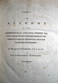
WILLIAM ROY Rare Navigation Book c1797 Trigonometry Between Paris & GreenwichLuis Porretta Fine Arts4.3(10)See Sold PriceMar 02, 2024
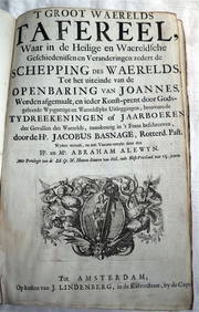
ACOBUS BASAGNE c1710 Theological History Numerous Engravings by De Hooghe Rare!Luis Porretta Fine Arts4.3(10)See Sold PriceMar 02, 2024
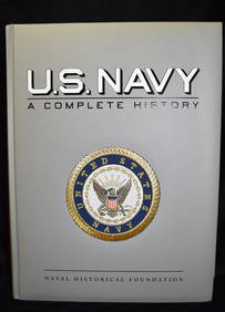
U.S. NAVY - A Complete History by Goodspeed, M. Hill 2003 MintNorth American Artifact Auctions4.7(198)See Sold PriceApr 20, 2024
[MAP]. NICHOLLS, Sutton (1668-1729). An Epitome of Sr. Will...Potter & Potter Auctions4.6(545)See Sold PriceMar 07, 2024
D'Entrecasteaux - Australia: Coasts of Van Diemen's Land (New Holland). 9Trillium Antique Prints & Rare Books4.5(32)See Sold PriceFeb 24, 2024
D'Entrecasteaux - Tasmania, Australia: Map of the Northern Portion of Recherche Bay. 5Trillium Antique Prints & Rare Books4.5(32)See Sold PriceFeb 24, 2024
D'Entrecasteaux - Australia: Chart of Van Diemen's Land (New Holland). 3Trillium Antique Prints & Rare Books4.5(32)See Sold PriceFeb 24, 2024
D'Entrecasteaux - Map of Australia (New Holland), New Zealand, and southern Asia and surroundingTrillium Antique Prints & Rare Books4.5(32)See Sold PriceFeb 24, 2024
De Jode, Rare, pub. 1593 - Map of Luxembourg (Lutzenburgii montuosissimi ac saltuosissimi ducatusTrillium Antique Prints & Rare Books4.5(32)See Sold PriceFeb 24, 2024
De Jode, Rare, pub. 1593 - Map of the British Isles [England, Scotland, Ireland] (Angliae Scotiae etTrillium Antique Prints & Rare Books4.5(32)See Sold PriceFeb 24, 2024
De Jode, Rare, pub. 1593 - Map of the Czech Republic or Kingdom of Bohemia (Chorographia insignisTrillium Antique Prints & Rare Books4.5(32)See Sold PriceFeb 24, 2024
De Jode, Rare, pub. 1593 - Map of the Middle East, Eastern Asia (Primae Partis Asiae accurataTrillium Antique Prints & Rare Books4.5(32)See Sold PriceFeb 24, 2024
Mivart & Keulemans - Mitchell's LoryTrillium Antique Prints & Rare Books4.5(32)See Sold PriceFeb 24, 2024
Audubon, NYSE Best Watercolor Ed - Pair: Brown Pelican & Reddish EgretTrillium Antique Prints & Rare Books4.5(32)See Sold PriceFeb 24, 2024
Redoute, Rare, Large Folio - Rose - Rosa Gallica flore giganteoTrillium Antique Prints & Rare Books4.5(32)See Sold PriceFeb 24, 2024
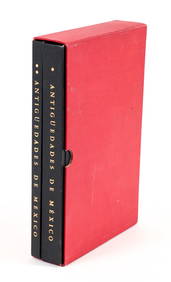
Antiguedades de Mexico Volumes 1 and 2 in slipcaseConcept Art Gallery4.7(510)See Sold PriceMar 06, 2024
DEATH NYC Hand Signed LARGE Print Framed 16x20in COA MONALISA COVID AMAZING RAREJasper524.5(9.9k)See Sold PriceFeb 28, 2024
DEATH NYC Hand Signed LARGE Print COA Framed 16x20in Air Vans Sneakers Rare A/PJasper524.5(9.9k)See Sold PriceFeb 28, 2024
1831 Large Letters Coronet Head Large Cent Coin NGC AU55 CACBK Auctions4.7(1.4k)See Sold PriceFeb 25, 2024


![[MAP]. 3 maps, US Topo. Engineers. [1848] (1 of 6)](https://p1.liveauctioneers.com/514/95447/48676200_1_x.jpg?height=282&quality=70&version=1477936208)


![[MAP]. NICHOLLS, Sutton (1668-1729). An Epitome of Sr. Will... (1 of 1)](https://p1.liveauctioneers.com/928/318880/171361281_1_x.jpg?height=282&quality=70&version=1707501302)


![De Jode, Rare, pub. 1593 - Map of the British Isles [England, Scotland, Ireland] (Angliae Scotiae et (1 of 2)](https://p1.liveauctioneers.com/6581/319571/171593327_1_x.jpg?height=282&quality=70&version=1707853304)