ATLAS of ANTIENT GEOGRAPHY by SAMUEL BUTLER 1843John McInnis Auctioneers,LLC4.5(505)See Sold PriceFeb 24, 2024
18TH C. ANTIQUE MAP: FRENCH & INDIAN WAR, FRAMEDThomaston Place Auction Galleries4.4(393)See Sold PriceFeb 24, 2024
Rand McNally Railroad Map Cabinet w/ 21 Railroad MapsRail & Road Auctions4.6(165)See Sold PriceMar 08, 2024
Keith Haring - Ink on New York Map, Best Buddies, Inscribed, Signed, and DatedSapphire Auction Gallery4(67)See Sold PriceMar 02, 2024
LATE 17TH C. FRENCH MAP OF THE NEW WORLD BY ALEXIS-HUBERT JAILLOT (1632-1712)Thomaston Place Auction Galleries4.4(393)See Sold PriceFeb 24, 2024
Central Railroad of New Jersey Map of Sandy Hook Route-ca. 1903JM Hobby Supply and Railroad Artifact Auctions4.4(127)See Sold PriceFeb 24, 2024
Lot of Six Mixed Atlas Box Cars-HO Scale-New in BoxJM Hobby Supply and Railroad Artifact Auctions4.4(127)See Sold PriceFeb 25, 2024
Rand McNally/Santa Fe Railroad Map of Iowa-1912JM Hobby Supply and Railroad Artifact Auctions4.4(127)See Sold PriceFeb 24, 2024
NICOLAES VISSCHER (NETHERLANDS, 1618-1709) MAP OF THE NEW WORLDThomaston Place Auction Galleries4.4(393)See Sold PriceFeb 24, 2024
17TH C. WORLD MAP BY NICOLAES VISSCHER (NETHERLANDS, 1618-1709)Thomaston Place Auction Galleries4.4(393)See Sold PriceFeb 24, 2024
Lot of Six Mixed Atlas Cabooses-HO Scale-New in BoxJM Hobby Supply and Railroad Artifact Auctions4.4(127)See Sold PriceFeb 25, 2024
Sold16V OSTERREICH‐UNGARNS LETZTER KRIEG 1914‐16V OSTERREICH‐UNGARNS LETZTER KRIEG 1914‐1918 1930‐1938 Austria‐Hungary′s Last War WWI Complete Set Maps History Europe Original Dust Jackets Battles Military TopographySee Sold Price
SoldAntique Map: RED SEA: KARTE DES ARABISCHEN MEERBUSENSMap with original decorative colour in outline shows the Red Sea. With an in-set map of the Gulf of Suez. Marked are towns, cities ports and smaller regions.The author Carsten Niebuhr (1733 - 1815) waSee Sold Price
SoldFOUR ANTIQUE MAP SETFOUR ANTIQUE MAP SET. MAP SET INCLUDED VERMONT, RHODE ISLAND, MAINE, NEW HAMPSHIRE. Height: 13 & 7 in. by Width: 12 & 6 in.See Sold Price
SoldHarmonia Macrocosmica Atlas Map Set [Cosmos]The 1963 Map Reprint set with title Harmonia Macrocosmica Atlas. In VG/EX-EX+ condition, and includes 10 maps and one title page measuring 18.5-in. x 22.5-in sheet size. Housed in original paper portfSee Sold Price
SoldHarmonia Macrocosmica Atlas Map Set [Cosmos]The 1963 Map Reprint set with title Harmonia Macrocosmica Atlas. In VG/EX-EX+ condition, and includes 12 maps and one title page (scuffed) measuring 18.5-in. x 22.5-in sheet size. Also included is a bSee Sold Price
SoldRichard William Seale (1732-1775), "Foldable 3 Map SetRichard William Seale (1732-1775), "Foldable 3 Map Set of England, Ireland, and Scotland," 1750, paper on linen, Each.- H.- W. - 46 in. (3 Pcs.)See Sold Price
Sold"Bartholemews Automobile Map Set of Great Britain,""Bartholemews Automobile Map Set of Great Britain," Nos. 1-23, now lacking #21-22, 21 Individual Leather Bound Folders, in a leather carrying case, Each- H.- 9 in., W.- 29 7/8 in.See Sold Price
SoldEncyclo. Britannica C1830 Set 2 Maps of Spain PortugalCopper Engraved Maps Published 1830-42, Edinburgh for "Encyclopedia Britannica" Seventh Edition. Centre fold as issued. Paper Size: 16 x 11 inch (40 x 28cm) Some toning, otherwise fineSee Sold Price
SoldTEXACO TOURING MAPS SET OF 3 VINTAGE ANTIQUETEXACO TOURING MAPS SET OF 3 VINTAGE ANTIQUE ADVERTISING PETROLIANASee Sold Price
SoldTEXACO TOURING MAPS SET OF 3 VINTAGE ANTIQUETEXACO TOURING MAPS SET OF 3 VINTAGE ANTIQUE ADVERTISING PETROLIANASee Sold Price
SoldVery rare map set. New Court - Russian Empire 18591.) Plan Estates Nowy Dvor Lieutenant Ivan Bulgak Lieutenant Guards Artillery Minsk Governorates of Slutsk County. Compiled in 1859. План ИмениSee Sold Price
SoldEARLY MARITIME TWO-VOLUME SET WITH MAPSEARLY MARITIME TWO-VOLUME SET WITH MAPS, "The Naval Gazetteer; of, Seaman's Complete Guide, Containing a Dull and Accurate Account, Alphabetically Arranged, of the Several Coasts of All the CountriesSee Sold Price
SoldPersonal Memoirs of U.S. GrantPersonal Memoirs of U.S. Grant , published by Charles L. Webster & Company, two volume set, illustrated maps, green cloth boards, ca. 1885/1886See Sold Price
SoldJohann Jacob Scheurmann," Atlas de la Suisse Zurich",Johann Jacob Scheurmann," Atlas de la Suisse Zurich", folding vellum on linen Map Set of 18 Folders in original box, 1822, Each- H. -9 in., W. -13 in.See Sold Price
SoldToms & Badeslade 1742 Hand Coloured Map of Worcester"A Map of Worcestershire" Hand Coloured Copper Engraved Map Published 1742, London for "Chorographia Britanniae, or a set of maps of all the counties in England and Wales" by Thomas Badeslade & WilliaSee Sold Price
SoldFRAMED MAP OF THE HOLY LANDACCORDING TO PROVENANCE ON BACK "MAP OF THE HOLY LAND BY JOSEPH MOXON ENGRAVED FOR WELL'S NEW SET OF MAPS 1671" Dimensions: 18 1/2" X 12 3/4" AND 26" X 21" OVERALLSee Sold Price
Sold1884 Cram Maps of Scotland and Ireland1884 Cram Maps of Scotland and Ireland -- Ireland (verso) Scotland. G Cram. 1884, Chicago. 11.7 X 9.5 in. A very nice set of maps with great deal of topographical, county, town, city and railroad lineSee Sold Price
Sold2V Hugh Murray HISTORICAL ACCOUNT OF DISCOVERIES AND2V Hugh Murray HISTORICAL ACCOUNT OF DISCOVERIES AND TRAVELS IN NORTH AMERICA 1829 Complete Set Folding Map United States Canada Polar Sea North-West Passage Emigration French and Spanish ExpeditionsSee Sold Price
SoldCOVARRUBIAS, Miguel (1904-1957). Pageant of the PacificCOVARRUBIAS, Miguel (1904-1957). Pageant of the Pacific Poster Maps. Set of Six. 1940. Complete FIRST EDITION set of six color lithograph poster maps on linen paper, after Covarrubias’ murals deSee Sold Price
Sold18th Century Book by William GuthrieNew Geographical, Historical, and Commercial Grammar an the Present State of the Kingdom of the Woods by William Gutherie and illustrated with the correct set of maps. Engraved by Mr. Kitchin, geograpSee Sold Price
Bradford: Set of 2 Antique Maps, World in HemispheresTitle/Content of Map: Set of 2 Maps together World in globular projection by Bradford Date Printed: 1835 Cartographer: T.G. Bradford Material/Medium: Paper Size: 9 1/2" x 13" each A comprehensive AtlaSee Sold Price
SoldGiovanni Baptista Guicciardini city mapsCartographers: Giovanni Baptista Guicciardini and Ludovico Guicciardini Title: [Map 1, Giovanni Baptista] Antwerpiae Nobilissimi Totius Orbis Terraru Emporii Typus Anno M.D.XCVIII [in a set with Map 2See Sold Price
SoldEdward Wells, 13 Maps incl. AfricaThirteen (13) Edward Wells (English, 1667-1727) maps plus title page from his rare atlas, A NEW SET OF MAPS BOTH OF ANCIENT AND PRESENT GEOGRAPHY, circa 1700-1712. All with decorative cartouches, dediSee Sold Price
1885 CIVIL WAR 1ed Famous Memoirs US Grant Sheridan Sherman 6v RARE LOT MapsSchilb Antiquarian Rare Books4.8(428)See Sold PriceMar 10, 2024
VENET / DEBUCOURT (1755-1832) Set 3 x Aquatint Engraved Hunting Scenes 23" x 16"Luis Porretta Fine Arts4.3(10)See Sold PriceMar 02, 2024
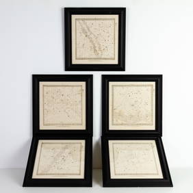
Set of Five Astronomical Zodiac Maps of the Stars by Baldwin & Gradock 1830Passion For Antiques4(24)See Sold PriceFeb 25, 2024
A Mickey Mouse Club Mattel Musical Map Record Set.Van Eaton Galleries4.6(99)See Sold PriceMar 02, 2024
1856 ARCTIC EXPLORATIONS 2nd GRINNEL EXPEDITION 2 v. E.KANE antique ILLUSTRATEDJasper524.5(9.9k)See Sold PriceFeb 27, 2024
Zhang Daqian beautiful woman ya set map hexadecor paper solid wood screenJapan Ancient Art Co. LTD4.4(45)See Sold PriceFeb 28, 2024
Camille Flammarion (1842 - 1925) - Set of 20 Astronomical Prints - Different colors of the moonProverde Auctions4.3(3)See Sold PriceFeb 28, 2024
Charles Antoine Lemaire (1800 - 1871) - Set of 4 Botanical Prints - Rose - Camellia Duchesse deProverde Auctions4.3(3)See Sold PriceFeb 28, 2024
Carl Axel Magnus Lindman (1856 - 1928) - Set of 10 Botanical Prints - Consolida regalis - CampanulaProverde Auctions4.3(3)See Sold PriceFeb 28, 2024
Phillip Otto Runge (1777-1810) - Set of 4 Botanical Prints - Flowers in Black & WhiteProverde Auctions4.3(3)See Sold PriceFeb 28, 2024
Henri Plon - Set of 10 Prints - Ethnography - Pekin - Japan - Anthropologic LithographyProverde Auctions4.3(3)See Sold PriceFeb 28, 2024
William H. Bartlett - Set of 12 views of America - Susquehanna - City of Louisville - ColoradoProverde Auctions4.3(3)See Sold PriceFeb 28, 2024
Set of 4 Maps - Netherlands - Seven United Provinces - Germany - Sweden, Denmark, Norway, FinlandProverde Auctions4.3(3)See Sold PriceFeb 28, 2024
Set of 3 Maps - Netherlands - Belgien - Switzerland - J. BarlowProverde Auctions4.3(3)See Sold PriceFeb 28, 2024


![Harmonia Macrocosmica Atlas Map Set [Cosmos] (1 of 14)](https://p1.liveauctioneers.com/5755/147592/74586064_1_x.jpg?height=282&quality=70&version=1565306622)
![Harmonia Macrocosmica Atlas Map Set [Cosmos] (1 of 19)](https://p1.liveauctioneers.com/5755/154409/77936384_1_x.jpg?height=282&quality=70&version=1573094011)