ATLAS of ANTIENT GEOGRAPHY by SAMUEL BUTLER 1843John McInnis Auctioneers,LLC4.5(505)See Sold PriceFeb 24, 2024
18TH C. ANTIQUE MAP: FRENCH & INDIAN WAR, FRAMEDThomaston Place Auction Galleries4.4(393)See Sold PriceFeb 24, 2024
Rand McNally Railroad Map Cabinet w/ 21 Railroad MapsRail & Road Auctions4.6(165)See Sold PriceMar 08, 2024
Keith Haring - Ink on New York Map, Best Buddies, Inscribed, Signed, and DatedSapphire Auction Gallery4(67)See Sold PriceMar 02, 2024
LATE 17TH C. FRENCH MAP OF THE NEW WORLD BY ALEXIS-HUBERT JAILLOT (1632-1712)Thomaston Place Auction Galleries4.4(393)See Sold PriceFeb 24, 2024
Central Railroad of New Jersey Map of Sandy Hook Route-ca. 1903JM Hobby Supply and Railroad Artifact Auctions4.4(127)See Sold PriceFeb 24, 2024
Lot of Six Mixed Atlas Box Cars-HO Scale-New in BoxJM Hobby Supply and Railroad Artifact Auctions4.4(127)See Sold PriceFeb 25, 2024
Rand McNally/Santa Fe Railroad Map of Iowa-1912JM Hobby Supply and Railroad Artifact Auctions4.4(127)See Sold PriceFeb 24, 2024
NICOLAES VISSCHER (NETHERLANDS, 1618-1709) MAP OF THE NEW WORLDThomaston Place Auction Galleries4.4(393)See Sold PriceFeb 24, 2024
17TH C. WORLD MAP BY NICOLAES VISSCHER (NETHERLANDS, 1618-1709)Thomaston Place Auction Galleries4.4(393)See Sold PriceFeb 24, 2024
Lot of Six Mixed Atlas Cabooses-HO Scale-New in BoxJM Hobby Supply and Railroad Artifact Auctions4.4(127)See Sold PriceFeb 25, 2024
Senex: Composite Map of Jamaica & British West IndiesMap: A new map of the English Empire in the Ocean of America or West Indies Cartographer: J. Senex Place/Date: London / 1721 Size: 23 3/4" x 20" Condition: "original color. overall age toning; trimmedSee Sold Price
SoldSenex: Antique Map Jamaica & British West Indies, 1721Title/Content of Map: A new map of the English Empire in the Ocean of America or West Indies Cartographer: J. Senex Place & Date: London / 1721 Size: 23 3/4" x 20" Condition: full wash color; repairedSee Sold Price
SoldSDUK: Antique Map of British West Indies Islands, 1830The British Islands in the West Indies The typically detailed SDUK composite map of British possessions in the Caribbean. The large central map of Jamaica is surrounded by fourteen inset maps of indivSee Sold Price
SoldJamaica British West Indies Antique Map, 1835Map: Jamaica British West Indies Antique Map Size: 15.5"W × 0.1"D × 13.0"H Year: 1835 Please note that this lot has a confidential reserve. When you leave a bid in advance of the auction, submit youSee Sold Price
BRITISH WEST INDIES Jamaica Trindad Antilles VirginTITLE/CONTENT OF MAP: 'BRITISH WEST INDIES; Jamaica, Trinidad, Virgin Islands, Leeward Islands (St Christopher, Nevis, Barbuda, Antigua), St Lucie, St Vincent, Barbadoes, Tobago, Dominica, Anguila, RoSee Sold Price
BRITISH WEST INDIES Jamaica Trindad Antilles Virgin Cayman Islands SDUK 1844 mapTITLE/CONTENT OF MAP: 'BRITISH WEST INDIES; Jamaica, Trinidad, Virgin Islands, Leeward Islands (St Christopher, Nevis, Barbuda, Antigua), St Lucie, St Vincent, Barbadoes, Tobago, Dominica, Anguila, RoSee Sold Price
BRITISH WEST INDIES Jamaica Virgin Cayman LeewardTITLE/CONTENT OF MAP: 'BRITISH WEST INDIES; Jamaica, Trinidad, Virgin Islands, Leeward Islands (St Christopher, Nevis, Barbuda, Antigua), St Lucie, St Vincent, Barbadoes, Tobago, Dominica, Anguila, RoSee Sold Price
BRITISH WEST INDIES Jamaica Virgin Cayman Leeward Islands Trinidad SDUK 1844 mapTITLE/CONTENT OF MAP: 'BRITISH WEST INDIES; Jamaica, Trinidad, Virgin Islands, Leeward Islands (St Christopher, Nevis, Barbuda, Antigua), St Lucie, St Vincent, Barbadoes, Tobago, Dominica, Anguila, RoSee Sold Price
BRITISH WEST INDIES Jamaica Virgin Cayman Leeward Islands Trinidad SDUK 1844 mapTITLE/CONTENT OF MAP: 'BRITISH WEST INDIES; Jamaica, Trinidad, Virgin Islands, Leeward Islands (St Christopher, Nevis, Barbuda, Antigua), St Lucie, St Vincent, Barbadoes, Tobago, Dominica, Anguila, RoSee Sold Price
BRITISH WEST INDIES Jamaica Trindad Antilles Virgin Cayman Islands SDUK 1844 mapTITLE/CONTENT OF MAP: 'BRITISH WEST INDIES; Jamaica, Trinidad, Virgin Islands, Leeward Islands (St Christopher, Nevis, Barbuda, Antigua), St Lucie, St Vincent, Barbadoes, Tobago, Dominica, Anguila, RoSee Sold Price
British West Indies. Jamaica Bermuda. St Vincent Barbados St Lucia 1904 mapTITLE/CONTENT OF MAP: 'Jamaica; St. Vincent, the Grenadines, Grenada, Barbadoes, St Lucia; Dominica; Bermudas' DATE PRINTED: 1904 IMAGE SIZE: Approx 9.5 x 16.5cm, 3.75 x 6.5 inches (Small) TYPE: AntiqSee Sold Price
1721 Senex Map of British Caribbean Islands -- A NewTitle: 1721 Senex Map of British Caribbean Islands -- A New Map of the English Empire in the Ocean of America or West Indies Date: 1721, London Cartographer: J Senex Size: 20.1 X 23.8 in. Additional ISee Sold Price
WEST INDIES. Lesser Antilles; maps of Jamaica; Guyana 1907 old antiqueTITLE/CONTENT OF MAP: 'West Indies: Lesser Antilles; Inset maps of Jamaica; British Guiana' DATE PRINTED: 1907 IMAGE SIZE: Approx 36.0 x 24.0cm, 14 x 9.25 inches (Large) TYPE: Colour antique map. ScalSee Sold Price
WEST INDIES. Lesser Antilles; maps of Jamaica; Guyana 1907 old antiqueTITLE/CONTENT OF MAP: 'West Indies: Lesser Antilles; Inset maps of Jamaica; British Guiana' DATE PRINTED: 1907 IMAGE SIZE: Approx 36.0 x 24.0cm, 14 x 9.25 inches (Large) TYPE: Colour antique map. ScalSee Sold Price
Map of the Bahama Islands, George Cram, 1892Map of the Bahama Islands. The highly detailed map of the Bahamas ("or British West Indies") and central Cuba rom Cram's Universal Atlas. On the verso is a map of Hispaniola, Jamaica and eastern Cuba,See Sold Price
BRITISH WEST INDIES. Jamaica Antilles Virgin CaymanTITLE/CONTENT OF MAP: 'THE BRITISH ISLANDS IN THE WEST INDIES; Jamaica, Trinidad, Virgin Islands, Leeward Islands (St Christopher, Nevis, Barbuda, Antigua), St Lucie, St Vincent, Barbadoes, Tobago, DoSee Sold Price
BRITISH WEST INDIES Jamaica Antigua Trinidad Dominica Bermuda Barbados 1876 mapTITLE/CONTENT OF MAP: 'West Indian Settlements; Jamaica; Antigua; Barbuda; Trinidad; St. Vincent; Dominica; Bermudas or Somers Is; Barbadoes; Tobago; St. Christopher' DATE PRINTED: 1876 IMAGE SIZE: ApSee Sold Price
BRITISH WEST INDIES ISLANDS. Jamaica Antilles Virgin Caymans. SDUK 1851 mapTITLE/CONTENT OF MAP: 'THE BRITISH ISLANDS IN THE WEST INDIES; Jamaica, Trinidad, Virgin Islands, Leeward Islands (St Christopher, Nevis, Barbuda, Antigua), St Lucie, St Vincent, Barbadoes, Tobago, DoSee Sold Price
BRITISH WEST INDIES ISLANDS. Jamaica Antilles Virgin Caymans. SDUK 1851 mapTITLE/CONTENT OF MAP: 'THE BRITISH ISLANDS IN THE WEST INDIES; Jamaica, Trinidad, Virgin Islands, Leeward Islands (St Christopher, Nevis, Barbuda, Antigua), St Lucie, St Vincent, Barbadoes, Tobago, DoSee Sold Price
BRITISH WEST INDIES Jamaica Antigua Trinidad Dominica Bermuda Barbados 1876 mapTITLE/CONTENT OF MAP: 'West Indian Settlements; Jamaica; Antigua; Barbuda; Trinidad; St. Vincent; Dominica; Bermudas or Somers Is; Barbadoes; Tobago; St. Christopher' DATE PRINTED: 1876 IMAGE SIZE: ApSee Sold Price
SoldBRITISH WEST INDIES ISLANDS. Jamaica Antilles VirginTITLE/CONTENT OF MAP: 'THE BRITISH ISLANDS IN THE WEST INDIES; Jamaica, Trinidad, Virgin Islands, Leeward Islands (St Christopher, Nevis, Barbuda, Antigua), St Lucie, St Vincent, Barbadoes, Tobago, DoSee Sold Price
BRITISH WEST INDIES ISLANDS. Jamaica Antilles VirginTITLE/CONTENT OF MAP: 'THE BRITISH ISLANDS IN THE WEST INDIES; Jamaica, Trinidad, Virgin Islands, Leeward Islands (St Christopher, Nevis, Barbuda, Antigua), St Lucie, St Vincent, Barbadoes, Tobago, DoSee Sold Price
SoldHomann: British West Indies/Atlantic Islands Map, 1740Map: Dominia Anglorum. British West Indies/Atlantic islands of St Christopher (St Kitts), Antigua, Bermuda, Jamaica & Barbados Date Printed: c1740 Image Size: Approx 52.5 x 59.5cm, 20.5 x 23.25 inchesSee Sold Price
SDUK: Map of British West Indies Islands, 1846Title/Content of Map: 'THE BRITISH ISLANDS IN THE WEST INDIES; Jamaica, Trinidad, Virgin Islands, Leeward Islands (St Christopher, Nevis, Barbuda, Antigua), St Lucie, St Vincent, Barbadoes, Tobago, DoSee Sold Price
Carey, pub. 1796 - Map of KentuckyTrillium Antique Prints & Rare Books4.5(32)See Sold PriceFeb 24, 2024
Carey, pub. 1796 - Map of the Tennassee State formerly part of North Carolina (Tennessee)Trillium Antique Prints & Rare Books4.5(32)See Sold PriceFeb 24, 2024
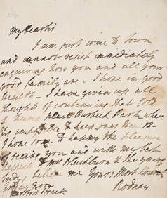
Rodney (Admiral Sir George Rodney, first Baron) Autograph Letter signed “Rodney?? to “MrForum Auctions4.3(53)See Sold PriceFeb 29, 2024
West Indies. South Coast of Jamaica from Port Royal to Pedro Bluff.Jasper524.5(9.9k)See Sold PriceFeb 27, 2024
Map of Part of the West Indies, Etc., Showing the Exact Position Of The U.S. War Steamer SanJasper524.5(9.9k)See Sold PriceFeb 27, 2024
West Indies. Rand, McNally & Co.'S Indexed Atlas Map of the West Indies.Jasper524.5(9.9k)See Sold PriceFeb 27, 2024
Geographical, Statistical, and Historical Map of the West Indies.Jasper524.5(9.9k)See Sold PriceFeb 27, 2024
OLD MAP of the West Indies/ Carta Esperica/ 1804Churchill Galleries3.7(217)See Sold PriceFeb 26, 2024
Cooke, George 1801 Antique Map. West Indies CaribbeanAlbion Auctions4.6(341)See Sold PriceMar 01, 2024
A Historic collection of 60 photographs in Albums each 20 x 25 cm, Agriculture on plantations in varHannam's Auctioneers Ltd4.3(396)See Sold PriceMar 01, 2024
Framed Tropical West Indies Map PrintRapid Estate Liquidators and Auction Gallery4.5(1.1k)See Sold PriceFeb 26, 2024