ATLAS of ANTIENT GEOGRAPHY by SAMUEL BUTLER 1843John McInnis Auctioneers,LLC4.6(502)See Sold PriceFeb 24, 2024
18TH C. ANTIQUE MAP: FRENCH & INDIAN WAR, FRAMEDThomaston Place Auction Galleries4.4(386)See Sold PriceFeb 24, 2024
Rand McNally Railroad Map Cabinet w/ 21 Railroad MapsRail & Road Auctions4.6(165)See Sold PriceMar 08, 2024
Keith Haring - Ink on New York Map, Best Buddies, Inscribed, Signed, and DatedSapphire Auction Gallery4(67)See Sold PriceMar 02, 2024
LATE 17TH C. FRENCH MAP OF THE NEW WORLD BY ALEXIS-HUBERT JAILLOT (1632-1712)Thomaston Place Auction Galleries4.4(386)See Sold PriceFeb 24, 2024
Central Railroad of New Jersey Map of Sandy Hook Route-ca. 1903JM Hobby Supply and Railroad Artifact Auctions4.4(126)See Sold PriceFeb 24, 2024
Lot of Six Mixed Atlas Box Cars-HO Scale-New in BoxJM Hobby Supply and Railroad Artifact Auctions4.4(126)See Sold PriceFeb 25, 2024
Rand McNally/Santa Fe Railroad Map of Iowa-1912JM Hobby Supply and Railroad Artifact Auctions4.4(126)See Sold PriceFeb 24, 2024
NICOLAES VISSCHER (NETHERLANDS, 1618-1709) MAP OF THE NEW WORLDThomaston Place Auction Galleries4.4(386)See Sold PriceFeb 24, 2024
17TH C. WORLD MAP BY NICOLAES VISSCHER (NETHERLANDS, 1618-1709)Thomaston Place Auction Galleries4.4(386)See Sold PriceFeb 24, 2024
Lot of Six Mixed Atlas Cabooses-HO Scale-New in BoxJM Hobby Supply and Railroad Artifact Auctions4.4(126)See Sold PriceFeb 25, 2024
SDUK: Antique Map of South Brazil, 1846Title/Content of Map: 'SOUTH AMERICA, SHEET III., SOUTH BRAZIL WITH PARAGUAY AND URUGUAY' The map includes some interesting brief anecdotes, eg "The Mate chiefly cultivated around Villa Rica" Bahia MiSee Sold Price
SDUK: Antique Map of South Brazil, 1846Title/Content of Map: 'SOUTH AMERICA, SHEET III., SOUTH BRAZIL WITH PARAGUAY AND URUGUAY' The map includes some interesting brief anecdotes, eg "The Mate chiefly cultivated around Villa Rica" Bahia MiSee Sold Price
SDUK: Antique Map of Amazonia, Brazil Ecuador 1846TITLE/CONTENT OF MAP: 'SOUTH AMERICA, SHEET I., ECUADOR, NEW GRANADA, VENEZUELA AND PARTS OF BRAZIL AND GUYANA' This fascinating map of the North West part of South America/Amazonia covers Ecuador, NeSee Sold Price
SDUK: Antique Map of Africa, 1846TITLE/CONTENT OF MAP: '[no title]' AFRICA South Europe Brazil Gnomonic Projection. Mountains of Kong. Marked on this map are the Mountains of Kong, a non-existent mountain range charted on English mapSee Sold Price
SDUK: Antique Map of Africa, 1846Title/Content of Map: AFRICA South Europe Brazil Gnomonic Projection. Mountains of Kong. Marked on this map are the Mountains of Kong, a non-existent mountain range charted on English maps of Africa fSee Sold Price
SDUK: Antique Map of Northwest South America, 1846Title/Content of Map: 'SOUTH AMERICA, SHEET I., ECUADOR, NEW GRANADA, VENEZUELA AND PARTS OF BRAZIL AND GUYANA' This fascinating map of the North West part of South America/Amazonia covers Ecuador, NeSee Sold Price
SoldSDUK: Antique Map of Amazonia, South America, 1846Title/Content of Map: 'SOUTH AMERICA, SHEET II., GUYANA AND NORTH BRAZIL' The map shows the locations of native Indian tribes and settlements. AMAZONIA. Showing Indian tribes. Guyana Surinam Brazil. RSee Sold Price
SDUK: Antique Map of Bolivia & Peru, 1846Title/Content of Map: 'SOUTH AMERICA, SHEET VI., BOLIVIA AND PERU WITH A PART OF BRAZIL' The map shows Bolivia with its Litoral (coastal) province, which it lost in the later War of the Pacific, cuttiSee Sold Price
SDUK: Antique Map of Bolivia & Peru, 1846Title/Content of Map: 'SOUTH AMERICA, SHEET VI., BOLIVIA AND PERU WITH A PART OF BRAZIL' The map shows Bolivia with its Litoral (coastal) province, which it lost in the later War of the Pacific, cuttiSee Sold Price
SoldSDUK: Antique Map of Bolivia & Peru, 1846TITLE/CONTENT OF MAP: 'SOUTH AMERICA, SHEET VI., BOLIVIA AND PERU WITH A PART OF BRAZIL' Bolivia Litoral / sea coast. The map shows Bolivia with its Litoral (coastal) province, which it lost in the laSee Sold Price
SDUK: Antique Map of NEW SOUTH WALES, 1846TITLE/CONTENT OF MAP: 'NEW SOUTH WALES. INSET SYDNEY FROM THE NEW SOUTH WALES ALMANACK.' The map is based on maps in the Colonial Office, the Surveys of the Australian Agricultural Company, and the roSee Sold Price
Africa South Europe Brazil Gnomonic Projection 1846 MapAfrica South Europe Brazil Gnomonic Projection. Mountains of Kong. Sduk 1846 Map. Title/content of Map: '[no Title]' marked on This Map Are the Mountains of Kong, a Non-existent Mountain Range ChartedSee Sold Price
SDUK: Antique Map of North America, 1846NORTH AMERICA, South to Panama.' The map shows national borders as they existed between 1836 and 1845, including the Republic of Texas as an independent state. It shows the US-Mexican border prior toSee Sold Price
SDUK: Antique Map of North America, 1846NORTH AMERICA, South to Panama.' The map shows national borders as they existed between 1836 and 1845, including the Republic of Texas as an independent state. It shows the US-Mexican border prior toSee Sold Price
SDUK: Antique Map of La Plata & Chile, 1846Title/Content of Map: 'SOUTH AMERICA, SHEET IV., LA PLATA AND CHILÉ' The map shows the routes of South American explorers & pioneers including Charles Darwin 1833, French 1826, Villarino 1782, GeneraSee Sold Price
SDUK: Antique Map of La Plata & Chile, 1846Title/Content of Map: 'SOUTH AMERICA, SHEET IV., LA PLATA AND CHILÉ' The map shows the routes of South American explorers & pioneers including Charles Darwin 1833, French 1826, Villarino 1782, GeneraSee Sold Price
SDUK: Antique Map of Bolivia & Peru, 1848Title/Content of Map: 'SOUTH AMERICA, SHEET VI., BOLIVIA AND PERU WITH A PART OF BRAZIL' Date Printed: This map was originally published by The Society for the Diffusion of Useful Knowledge This editiSee Sold Price
SDUK: Antique Gnomonic Map of the Americas, 1846Title/Content of Map: 'WORLD ON GNOMONIC PROJECTION, II., America'. The map was originally engraved prior to or during the Texas Republic, and borders on the map have been drawn to show Texas as beingSee Sold Price
AFRICA South Europe Brazil Gnomonic Projection. Mountains of Kong. SDUK 1846 mapTITLE OF MAP (NOT PRINTED ON THE PAGE):'WORLD ON GNOMONIC PROJECTION, I., Africa and South Europe' Marked on this map are the Mountains of Kong, a non-existent mountain range charted on English maps oSee Sold Price
AFRICA South Europe Brazil Gnomonic Projection. Mountains of Kong. SDUK 1846 mapTITLE OF MAP (NOT PRINTED ON THE PAGE):'WORLD ON GNOMONIC PROJECTION, I., Africa and South Europe' Marked on this map are the Mountains of Kong, a non-existent mountain range charted on English maps oSee Sold Price
SoldSDUK: Antique Map of South Scotland, 1845Title/Content of Map: 'SCOTLAND, I,. South to Perthshire; inset table of former county names' Castles kirks railways. Date Printed: 1845 Image Size: Approx 29.5 x 39.5cm, 11.75 x 15.5 inches (Large) TSee Sold Price
SDUK: Antique Map of Florida, 1846Title/Content of Map: 'NORTH AMERICA, XlV., Florida' showing Seminole Indian district & forts. Keys. Date Printed: 1846 Image Size: Approx 42.0 x 33.0cm, 16.5 x 13 inches (Large) Type: Antique steel eSee Sold Price
SDUK: Antique Map of Florida, 1846Title/Content of Map: 'NORTH AMERICA, XlV., Florida' showing Seminole Indian district & forts. Keys. Date Printed: 1846 Image Size: Approx 42.0 x 33.0cm, 16.5 x 13 inches (Large) Type: Antique steel eSee Sold Price
SDUK: Antique Map of Florida, 1846Title/Content of Map: 'NORTH AMERICA, XlV., Florida'. FLORIDA showing Seminole Indian district & forts. Keys. SDUK, 1846 antique map Date Printed: 1846 Image Size: Approx 42.0 x 33.0cm, 16.5 x 13 inchSee Sold Price
Carey, pub. 1796 - Map of The State of South CarolinaTrillium Antique Prints & Rare Books4.5(30)See Sold PriceFeb 24, 2024
WEST AFRICA Explorers' routes Senegal Ashanti. Mountains of Kong. SDUK 1857 mapJasper524.5(9.8k)See Sold PriceFeb 28, 2024
AFRICA. Map pre-dating much exploration. Mountains of Kong. SDUK 1851 oldJasper524.5(9.8k)See Sold PriceFeb 28, 2024
NORTH AFRICA OF BABRBARY V Parts of Tripoli & Egypt. Libya Tribes. SDUK 1846 mapJasper524.5(9.8k)See Sold PriceFeb 28, 2024
SOUTH CENTRAL AFRICA. Shows Zambesi river as circular! WELLER 1863 old mapJasper524.5(9.8k)See Sold PriceFeb 28, 2024
Coste Orientale d’Afrique…' South Africa. Mozambique channel. BELLIN 1746 mapJasper524.5(9.8k)See Sold PriceFeb 28, 2024
Africa. Congo Free Trade Area. British South Africa Company. STANFORD 1896 mapJasper524.5(9.8k)See Sold PriceFeb 28, 2024
NORTH AFRICA BARBARY. Parts of Tripoli (Libya) & Egypt. Tribes. SDUK 1844 mapJasper524.5(9.8k)See Sold PriceFeb 28, 2024
NORTH AFRICA BARBARY. Parts of Tripoli (Libya) & Egypt. Tribes. SDUK 1844 mapJasper524.5(9.8k)See Sold PriceFeb 28, 2024
NORTH AFRICA OF BABRBARY V Parts of Tripoli & Egypt. Libya Tribes. SDUK 1851 mapJasper524.5(9.8k)See Sold PriceFeb 28, 2024
East coast of Africa from the Cape… South Africa Mozambique. CHILD 1745 mapJasper524.5(9.8k)See Sold PriceFeb 28, 2024
AFRICA NW & SOUTH. Maghreb. Cape Colony electoral divisions. JOHNSTON 1906 mapJasper524.5(9.8k)See Sold PriceFeb 28, 2024
Africa. Congo Free Trade Area. British South Africa Company. STANFORD 1894 mapJasper524.5(9.8k)See Sold PriceFeb 28, 2024
Coste Orientale d’Afrique'. South Africa Mozambique BELLIN/SCHLEY 1747 mapJasper524.5(9.8k)See Sold PriceFeb 28, 2024
Afrique. Pays des Hottentots #51. Botswana South Africa. VANDERMAELEN 1827 mapJasper524.5(9.8k)See Sold PriceFeb 28, 2024
NORTH AFRICA BARBARY. Parts of Tripoli (Libya) & Egypt. Tribes. SDUK 1848 mapJasper524.5(9.8k)See Sold PriceFeb 28, 2024
NAMIBIA. South West Africa protectorate. HARMSWORTH 1920 old antique map chartJasper524.5(9.8k)See Sold PriceFeb 28, 2024
Churchill & Nieuhof 1744 Folio Map. Cape of Good Hope, South AfricaAlbion Auctions4.6(336)See Sold PriceMar 01, 2024
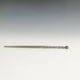
Antique South American Silver Judaica Torah PointerLion and Unicorn4.7(1.8k)See Sold PriceMar 14, 2024