ATLAS of ANTIENT GEOGRAPHY by SAMUEL BUTLER 1843John McInnis Auctioneers,LLC4.6(504)See Sold PriceFeb 24, 2024
18TH C. ANTIQUE MAP: FRENCH & INDIAN WAR, FRAMEDThomaston Place Auction Galleries4.4(389)See Sold PriceFeb 24, 2024
Rand McNally Railroad Map Cabinet w/ 21 Railroad MapsRail & Road Auctions4.6(165)See Sold PriceMar 08, 2024
Keith Haring - Ink on New York Map, Best Buddies, Inscribed, Signed, and DatedSapphire Auction Gallery4.1(67)See Sold PriceMar 02, 2024
LATE 17TH C. FRENCH MAP OF THE NEW WORLD BY ALEXIS-HUBERT JAILLOT (1632-1712)Thomaston Place Auction Galleries4.4(389)See Sold PriceFeb 24, 2024
Central Railroad of New Jersey Map of Sandy Hook Route-ca. 1903JM Hobby Supply and Railroad Artifact Auctions4.4(126)See Sold PriceFeb 24, 2024
Lot of Six Mixed Atlas Box Cars-HO Scale-New in BoxJM Hobby Supply and Railroad Artifact Auctions4.4(126)See Sold PriceFeb 25, 2024
Rand McNally/Santa Fe Railroad Map of Iowa-1912JM Hobby Supply and Railroad Artifact Auctions4.4(126)See Sold PriceFeb 24, 2024
NICOLAES VISSCHER (NETHERLANDS, 1618-1709) MAP OF THE NEW WORLDThomaston Place Auction Galleries4.4(389)See Sold PriceFeb 24, 2024
17TH C. WORLD MAP BY NICOLAES VISSCHER (NETHERLANDS, 1618-1709)Thomaston Place Auction Galleries4.4(389)See Sold PriceFeb 24, 2024
Lot of Six Mixed Atlas Cabooses-HO Scale-New in BoxJM Hobby Supply and Railroad Artifact Auctions4.4(126)See Sold PriceFeb 25, 2024
SDUK: Antique Map of Italy in 3 Sheets, 1830Title/Content of Map: Italy I, II, and III Cartographer: Baldwin & Cradock, Society for the Diffusion of Useful Knowledge Place & Date: London / 1830/1852 Size: 14 7/8" x 11 1/4" (the largest of the tSee Sold Price
Baldwin & Cradock/SDUK: “Modern” Italy in 3 SheetsTitle: Baldwin & Cradock/SDUK: “Modern” Italy in 3 Sheets Cartographer: Baldwin & Cradock, Society for the Diffusion of Useful KnowledgePlace/Date: London / 1830/1852 Size: 14 7/8" x 11 1/4" (See Sold Price
SoldSDUK: Detailed Map of Ancient Italy in 3 SheetsMap Title: Ancient Italy I, II, and III Cartographer: Baldwin & Cradock, Society for the Diffusion of Useful Knowledge Place/Date: London / 1832/1852 Size: 14 7/8" x 11 1/4" (largest of the three mapsSee Sold Price
SDUK: Detailed Map of Ancient Italy in 3 SheetsTitle: Ancient Italy I, II, and III Cartographer: Baldwin & Cradock, Society for the Diffusion of Useful Knowledge Place/Date: London / 1832/1852 Size: 14 7/8" x 11 1/4" (largest of the three maps) CoSee Sold Price
SoldMattheus Seutter, Antique Map of Firenza, c.1730Antique map of Firenza / Florence, Italy by Mattheus Seutter, Augsburg c.1730. Copperplate engraving, the image measures 18-7/8" x 22". Sheet measurement 20-3/8" x 25". Elaborate cartouche of the citySee Sold Price
SDUK: Antique Map of Ancient Africa (Libya) in 2 sheetsMap: Ancient Africa or Libya, parts I and II Cartographer: Society for the Diffusion of Useful Knowledge Place & Date: London / 1840/1852 Size: 15 1/4" x 12 3/8" (each map) Condition: b&w, overall ageSee Sold Price
Baldwin & Cradock/SDUK: “Modern” Italy in 3 SheetsMap: Italy I, II, and III Cartographer: Baldwin & Cradock, Society for the Diffusion of Useful Knowledge Place/Date: London / 1830/1852 Size: 14 7/8" x 11 1/4" (the largest of the three maps) ConditioSee Sold Price
SoldSpice Islands Southeast Asia Antique MapSpice Islands Southeast Asia antique map. An early map of Italy. Loose, unframed and not glued or mounted, etc. m). Sheet size 18 3/4" x 24 3/4". Fair to good condition with tears in margin and paperSee Sold Price
Baldwin & Cradock/SDUK: Modern Italy in 3 SheetsReserve Reduced! Map Title: Italy I, II, and III Cartographer: Baldwin & Cradock, Society for the Diffusion of Useful Knowledge Place/Date: London / 1830/1852 Size: 14 7/8" x 11 1/4" (the largest of tSee Sold Price
SoldBaldwin & Cradock/SDUK: “Modern” Italy in 3 SheetsCartographer: Baldwin & Cradock, Society for the Diffusion of Useful Knowledge Place/Date: London / 1830/1852 Size: 14 7/8" x 11 1/4" (the largest of the three maps) Condition: b&w; light overall ageSee Sold Price
Baldwin & Cradock/SDUK: Ancient Italy in 3 SheetsTitle: Baldwin & Cradock/SDUK: Ancient Italy in 3 Sheets Cartographer: Baldwin & Cradock, Society for the Diffusion of Useful KnowledgePlace/Date: London / 1832/1852 Size: 14 7/8" x 11 1/4" (largest oSee Sold Price
1830 SDUK Map of Roman Italy's Central to South Portion -- Ancient Italy IITitle: 1830 SDUK Map of Roman Italy's Central to South Portion -- Ancient Italy II Cartographer: SDUK Date/Place: 1830, London Dimensions: 9.9 X 15.3 in. Description: This is an excellent map of centrSee Sold Price
1830 SDUK Map of Roman Italy's Central to South Portion -- Ancient Italy IITitle: 1830 SDUK Map of Roman Italy's Central to South Portion -- Ancient Italy II Cartographer: SDUK Year / Place: 1830, London Map Dimension (in.): 9.9 X 15.3 in. This is an excellent map of centralSee Sold Price
1830 SDUK Map of Central to South Italy -- Italy IITitle: 1830 SDUK Map of Central to South Italy -- Italy II Cartographer: SDUK Date/Place: 1830, London Dimensions: 9.9 X 15.3 in. Description: This is an excellent map of central to south Italy. The mSee Sold Price
SoldSDUK: Antique Map of Italy, 1845Title/Content of Map: 'ITALY IV, General map including Sicily, Malta, Sardinia, and Corsica' Date Printed: 1845 Image Size: Approx 40.5 x 34.5cm, 16 x 13.5 inches (Large) Type: Antique steel engravedSee Sold Price
SDUK: Antique Map of Italy, 1845Title/Content of Map: 'ITALY IV, General map including Sicily, Malta, Sardinia, and Corsica' Date Printed: 1845 Image Size: Approx 40.5 x 34.5cm, 16 x 13.5 inches (Large) Type: Antique steel engravedSee Sold Price
SDUK: Antique Map of Italy, 1840Map: Italy IV Cartographer: Society for the Diffusion of Useful Knowledge Place & Date: London / 1840/1852 Size: 15 5/8" x 12 5/8" Condition: b&w; upper right corner creased The general map of Italy fSee Sold Price
SDUK: Antique Map of Italy, 1845TITLE/CONTENT OF MAP: 'ITALY IV, General map including Sicily, Malta, Sardinia, and Corsica' DATE PRINTED: 1845 IMAGE SIZE: Approx 40.5 x 34.5cm, 16 x 13.5 inches (Large) TYPE: Antique steel engravedSee Sold Price
SDUK: Antique Map of ITALY Sardinian States 1845TITLE/CONTENT OF MAP: 'ITALY I., North to Arezzo' The Sardinian States include Savoy/Savoie and the Comté de Nice, later ceded to France DATE PRINTED: 1845 IMAGE SIZE: Approx 26.5 x 39.5cm, 10.25 x 1See Sold Price
SoldSDUK: Antique Map of Florence, Italy, 1835Title/Content of Map: Florence Cartographer: Baldwin & Cradock / SDUK Place & Date: London / 1835 Size: 14 7/8" x 11 1/8" Condition: river, forts, walls and gardens colored; light overall age toningSee Sold Price
SDUK: Antique Map of Southern Italy, 1845Title/Content of Map: 'ITALY II., To Gulf of Tarento'. Naples Stato Pontifico Toscana. Original hand colour. Date Printed: 1845 Image Size: Approx 27.5 x 40.5cm, 10.75 x 16 inches (Large) Type: AntiquSee Sold Price
SDUK: Antique Map of Parma, Italy, 1847Title/Content of Map: 'PARMA'. Antique town city map plan & panorama. Parme. Date Printed: 1847 Image Size: Approx 34.0 x 39.0cm, 13.25 x 15.25 inches (Large) Type: Antique steel engraved map with oriSee Sold Price
Johnson: Antique Map of Italy (2 sheets), 1861Title/Content of Map: 1861 Johnson's Italy Map (2 sheets) -- Johnson's Northern Italy on sheet with Johnson's Southern Italy Date Printed: 1861, New York Cartographer: Johnson & Browning Size: 24 x 15See Sold Price
Johnson: Antique Map of Italy (2 sheets), 1861Map: 1861 Johnson's Italy Map (2 sheets) -- Johnson's Northern Italy on sheet with Johnson's Southern Italy Cartographer: Johnson & Browning Year / Place: 1861, New York Map Dimensions: 24 x 15 in. CoSee Sold Price
Antique Simplex Wood Case Time Clock with Time Card HolderMatthew Bullock Auctioneers4.7(1.8k)See Sold PriceFeb 24, 2024
De Jode, Rare, pub. 1593 - Map of Italy (Italiae Totius Orbis olim Domatricis Nova ExactissTrillium Antique Prints & Rare Books4.5(30)See Sold PriceFeb 24, 2024
1568 BIBLE in FRENCH & LATIN antique BIBLIA GALLICA by Rene Benoist 16th CENTURYJasper524.5(9.8k)See Sold PriceFeb 27, 2024
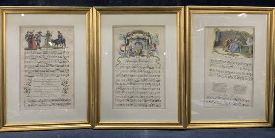
3 Antique Full Color Plate Etching Music SheetsThe Benefit Shop Foundation Inc.4.3(2.9k)See Sold PriceMar 13, 2024
WEST AFRICA Explorers' routes Senegal Ashanti. Mountains of Kong. SDUK 1857 mapJasper524.5(9.8k)See Sold PriceFeb 28, 2024
AFRICA. Map pre-dating much exploration. Mountains of Kong. SDUK 1851 oldJasper524.5(9.8k)See Sold PriceFeb 28, 2024
Cooke, George 1801 Antique Map. Italy, Sicily, Sardinia & CorsicaAlbion Auctions4.6(341)See Sold PriceMar 01, 2024
Antique Map of Poland, 1700 by Guillaume De Lisle, ParisAntiques Online Auctions4.6(410)See Sold PriceMar 14, 2024
Antique Map of France, 1703 by Gillaume Del Isle PrintAntiques Online Auctions4.6(410)See Sold PriceMar 14, 2024