ATLAS of ANTIENT GEOGRAPHY by SAMUEL BUTLER 1843John McInnis Auctioneers,LLC4.5(505)See Sold PriceFeb 24, 2024
18TH C. ANTIQUE MAP: FRENCH & INDIAN WAR, FRAMEDThomaston Place Auction Galleries4.4(394)See Sold PriceFeb 24, 2024
Rand McNally Railroad Map Cabinet w/ 21 Railroad MapsRail & Road Auctions4.6(165)See Sold PriceMar 08, 2024
Keith Haring - Ink on New York Map, Best Buddies, Inscribed, Signed, and DatedSapphire Auction Gallery4.1(67)See Sold PriceMar 02, 2024
LATE 17TH C. FRENCH MAP OF THE NEW WORLD BY ALEXIS-HUBERT JAILLOT (1632-1712)Thomaston Place Auction Galleries4.4(394)See Sold PriceFeb 24, 2024
Central Railroad of New Jersey Map of Sandy Hook Route-ca. 1903JM Hobby Supply and Railroad Artifact Auctions4.4(127)See Sold PriceFeb 24, 2024
Lot of Six Mixed Atlas Box Cars-HO Scale-New in BoxJM Hobby Supply and Railroad Artifact Auctions4.4(127)See Sold PriceFeb 25, 2024
Rand McNally/Santa Fe Railroad Map of Iowa-1912JM Hobby Supply and Railroad Artifact Auctions4.4(127)See Sold PriceFeb 24, 2024
NICOLAES VISSCHER (NETHERLANDS, 1618-1709) MAP OF THE NEW WORLDThomaston Place Auction Galleries4.4(394)See Sold PriceFeb 24, 2024
17TH C. WORLD MAP BY NICOLAES VISSCHER (NETHERLANDS, 1618-1709)Thomaston Place Auction Galleries4.4(394)See Sold PriceFeb 24, 2024
Lot of Six Mixed Atlas Cabooses-HO Scale-New in BoxJM Hobby Supply and Railroad Artifact Auctions4.4(127)See Sold PriceFeb 25, 2024
Sardinia & Genoa.- Dury (Andrew) A Chorographical MapSardinia & Genoa.- Dury (Andrew) A Chorographical Map of the King of Sardinia's Dominions [&] A Chorographical Map of the Territories of the Republic of Genoa, 2 parts in 1, printed title in red and bSee Sold Price
Dury, Andrew A map of the provinces of Delhi, Agrah,Dury, Andrew A map of the provinces of Delhi, Agrah, Oude and Allahabad. Teilkolorierte Kupferstichkarte in 2 Teilen (nicht zusammengesetzt). London, Laurie & Whittle, 1794. 109 x 107 cm. Große, detaSee Sold Price
SoldIndia.- Dury (Andrew) A Map of the Provinces of Delhi,India.- Dury (Andrew) A Map of the Provinces of Delhi, Agrah, Oude, and Ellahabad, comprehending the Countries lying between Delhi, and the Bengal-Provinces, Surveyed by James Rennell, large two-sheetSee Sold Price
London.- Andrews (John) and Andrew Dury. - A Map of theand Andrew Dury. A Map of the Country Sixty Five Miles Round London from Actual Surveys, 19 of 20 double-page sheets, lacking sheet 12 due west of London, with large oval title on sheet 1, dedicationSee Sold Price
Laurie & Whitle, "An Actual Survey of the Provinces ofLaurie & Whitle, "An Actual Survey of the Provinces of Bengal, Bohar, etc. by James Rennell from a map by Andrew Dury," 1794, in two parts, Each- H. - 21 1/2 in., W. - 28 3/4 in. (2 Pcs.)See Sold Price
SoldAndrews & Dury. A Map of the County of KentAndrews (John) and Andrew Dury A Map of the County of Kent,index map, only, for the 25-sheet map of Kent, engraved map with original hand-colouring in outline, 515 x 725mm., central vertical fSee Sold Price
SoldAndrews (John)Andrews (John) and Andrew Dury. A Map of the Country Sixty Five Miles Round London from Actual Surveys, engraved map on 20 double-page sheets with large oval title on sheet 1, dedication ovalSee Sold Price
SoldENGRAVED & COLORED 1761 POCKET ATLAS.Dury, Andrew. A New, General, and Universal Atlas, Containing Forty five Maps by Andrew Dury, Engraved by Mr. Kitchin, & others. [London:] Printed for & sold by A. Dury at the Indian Queen … & Robt.See Sold Price
SoldHERTFORDSHIRE. DURY, ANDREW & JOHN ANDREWSHertfordshire. Dury, Andrew and John Andrews. A Topographical Map of Hartford-Shire, from an Actual Survey, folding dissected map backed on to linen, on 36 sheets, a few manuscript marks, offsetting,See Sold Price
Andrews (John) and Andrew Dury. A New Travelling MAndrews (John) and Andrew Dury. A New Travelling Map of the Country Round LondonExtending from the North to South 190 Miles and East to West 150 Miles, engraved map with hand-colouring, 1010 xSee Sold Price
SoldSussex.- South Coast.- Andrews (John) and Andrew Dury.Sussex.- South Coast.- Andrews (John) and Andrew Dury. Two sheets from 'A Map of the Country Sixty Five Miles Round London', sheet 18 and 19, showing from Little Hampton to Rye, including Brighton, LeSee Sold Price
SoldAndrew Dury and John Andrews, 'A Topographical Map ofAndrew Dury and John Andrews, 'A Topographical Map of Hartford-shire From An Actual Survey...', hand coloured engraving, published 1766, mounted over margins, 52 x 69cm; and: Robert Morden, 'ShropshirSee Sold Price
SoldKITCHIN, THOMAS; and DURY, ANDREW. British Dominions inKITCHIN, THOMAS; and DURY, ANDREW. British Dominions in America Agreeable to the Treaty of 1763; Divided into the Several Provinces and Jurisdictions. Double-page engraved map of colonial North AmericSee Sold Price
SoldDury (Andrew) and P. Bell. Environs of London takeDury (Andrew) and P. Bell. Environs of London taken from Actual Surveys,1st edition, from Luton to Bletchingley and from Canvey Island to Great Marlow, title vignette upper left, engraved mapSee Sold Price
SoldDury (Andrew) - An Actual Survey of the Provinces ofthe survey by Major James Rennell, Surveyor General to the honourable the East India Company, engraved map with original hand-colouring on 2 sheets, unjoined, approx 995 x 1500mm., if joined, the sheeSee Sold Price
SoldIndia.- Dury (Andrew) An Actual Survey of the ProvincesIndia.- Dury (Andrew) An Actual Survey of the Provinces of Bengal, Bahar &c., By Major James Rennell [...] published from a drawing by A. Dury, large two-sheet wall map of Bengal, illustrating the couSee Sold Price
SoldBBRI Dury (Andrew) A Collection of Plans of the PrBBRI Dury (Andrew) A Collection of Plans of the Principal Cities of Great Britain and Ireland,with Maps of the Coast of the Said Kingdoms, Drawn from the most Accurate Surveys, In particular tSee Sold Price
SoldDury (Andrew) A New General & Universal AtlasDury (Andrew) A New General & Universal Atlas, 39 engraved maps on 45 plates, 6 folding, all outlined in colour, some offsetting, contemporary calf, rubbed, rebacked and recornered, oblong 8voSee Sold Price
SoldDury (Andrew) A New General & Universal AtlasDury (Andrew) A New General & Universal Atlas,engraved title, dedication and contents leaf, 39 engraved maps on 45 plates, 6 folding, all outlined in colour, title browned, 3 fly-leaves cut awSee Sold Price
SoldDury (Andrew) A Collection of the Plans of the PriDury (Andrew) A Collection of the Plans of the Principal Cities of Great Britain and Ireland:with Maps of the Coast of the Said Kingdoms, engraved title and dedication leaf, contents, 20 mapsSee Sold Price
Sold1 piece. Hand-Colored Engraved Map. Easburn, Benja1 piece. Hand-Colored Engraved Map. Easburn, Benjamin. A Plan of The City of Philadelphia, The Capital of Pennsylvania,..." London: Andrew Dury, 1776. Engraved by P. Andre. 20 1/4 x 26 7/8 inches; 514See Sold Price
SoldKent.- Andrews (John Andrew Dury and W. Herbert) - A25-sheet map, with index map and plan of Canterbury in addition, 27 sheet double-page engraved map sheets, unjoined, many with original hand-colouring in outline, occasional slight browning, generallySee Sold Price
EAST INDIA COMPANY Map of the provinces oEAST INDIA COMPANY Map of the provinces of Bengal, Bahar, etc. by Andrew Dury, 1776. 21 x 147 cms. Hogarth frame. Printed on two sheets, hand coloured in outline.See Sold Price
SoldKent.- Andrews (John) and Andrew Dury. After - Afacsimile 25 double-sheet county map, with index sheet, maroon cloth mounted with publisher's paper label, folio (515 x 405mm.), Lympne Castle, Kent, Harry Margary, 1968.See Sold Price
HANNAH ADAMS c1805 View Of Religions & Essay On Truth Tan Calf No SpineLuis Porretta Fine Arts4.3(10)See Sold PriceMar 02, 2024
John Boydell / Carlo Dolci 1768 Scarce Engraving Death of St Andrew 17" x 12"Luis Porretta Fine Arts4.3(10)See Sold PriceMar 02, 2024
ANDREW RAYMOND JANSON OIL ON BOARD ADIRONDACKSCharleston Estate Services Ltd.4.5(72)See Sold PriceMar 03, 2024
Catherwood - General View of Uxmal, Taken from the Archway of Las Monjas, Looking SouthTrillium Antique Prints & Rare Books4.5(33)See Sold PriceFeb 24, 2024
GEORGE ANDREW CORLEY (DATES UNKNOWN) U.S. TEAM SKI TRYOUTS / MT. HOOD OREGON. 1939.Swann Auction Galleries4.4(71)See Sold PriceFeb 29, 2024
Foulis.- Corsica.- Boswell (James) An Account of Corsica, the journal of a tour to that island; andForum Auctions4.4(54)See Sold PriceFeb 29, 2024
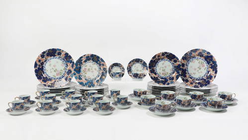
A Haviland Limoges porcelain part dinner serviceAndrew Jones Auctions4.7(208)See Sold PriceFeb 28, 2024
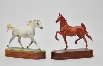
Two Royal Worcester porcelain models of horsesAndrew Jones Auctions4.7(208)See Sold PriceFeb 28, 2024
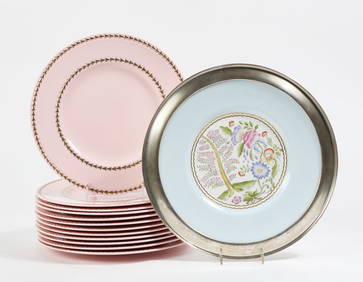
A set of twelve Wedgwood porcelain dinner platesAndrew Jones Auctions4.7(208)See Sold PriceFeb 28, 2024
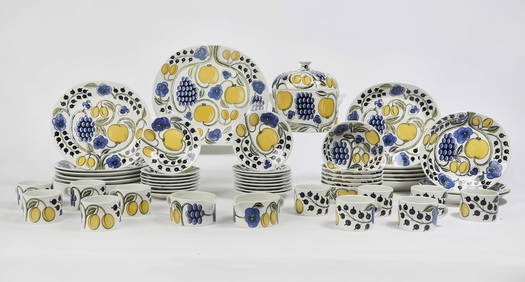
An Arabia of Finland ceramic part dinner serviceAndrew Jones Auctions4.7(208)See Sold PriceFeb 28, 2024
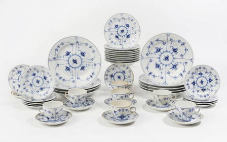
A Royal Copenhagen porcelain part dinner serviceAndrew Jones Auctions4.7(208)See Sold PriceFeb 29, 2024
San Xavier Del Bac Mission, Edward S. Curtis photogravurePBA Galleries4.7(389)See Sold PriceMar 07, 2024
Cooke, George 1801 Antique Map. Italy, Sicily, Sardinia & CorsicaAlbion Auctions4.7(341)See Sold PriceMar 01, 2024