ATLAS of ANTIENT GEOGRAPHY by SAMUEL BUTLER 1843John McInnis Auctioneers,LLC4.6(502)See Sold PriceFeb 24, 2024
18TH C. ANTIQUE MAP: FRENCH & INDIAN WAR, FRAMEDThomaston Place Auction Galleries4.4(386)See Sold PriceFeb 24, 2024
Rand McNally Railroad Map Cabinet w/ 21 Railroad MapsRail & Road Auctions4.6(165)See Sold PriceMar 08, 2024
Keith Haring - Ink on New York Map, Best Buddies, Inscribed, Signed, and DatedSapphire Auction Gallery4(67)See Sold PriceMar 02, 2024
LATE 17TH C. FRENCH MAP OF THE NEW WORLD BY ALEXIS-HUBERT JAILLOT (1632-1712)Thomaston Place Auction Galleries4.4(386)See Sold PriceFeb 24, 2024
Central Railroad of New Jersey Map of Sandy Hook Route-ca. 1903JM Hobby Supply and Railroad Artifact Auctions4.4(126)See Sold PriceFeb 24, 2024
Lot of Six Mixed Atlas Box Cars-HO Scale-New in BoxJM Hobby Supply and Railroad Artifact Auctions4.4(126)See Sold PriceFeb 25, 2024
Rand McNally/Santa Fe Railroad Map of Iowa-1912JM Hobby Supply and Railroad Artifact Auctions4.4(126)See Sold PriceFeb 24, 2024
NICOLAES VISSCHER (NETHERLANDS, 1618-1709) MAP OF THE NEW WORLDThomaston Place Auction Galleries4.4(386)See Sold PriceFeb 24, 2024
17TH C. WORLD MAP BY NICOLAES VISSCHER (NETHERLANDS, 1618-1709)Thomaston Place Auction Galleries4.4(386)See Sold PriceFeb 24, 2024
Lot of Six Mixed Atlas Cabooses-HO Scale-New in BoxJM Hobby Supply and Railroad Artifact Auctions4.4(126)See Sold PriceFeb 25, 2024
SoldRussia 1818-1835 Pair of Antique Maps"Russian Empire" Copper Engraved Map Published 1818, London for "A New and Complete System of Universal Geography" by Christopher Kelly. Together with "Russia in Europe Part V" Steel Engraved Map PublSee Sold Price
SoldPAIR ANTIQUE MAP CASES WITH MAPSPAIR ANTIQUE MAP CASES WITH MAPS: Early 20th century, 12 drawers each with maps of US states and regions in bottom of each drawer. Cases are stackable. Note overall condition. MUST CALL FOR CONDITIONSee Sold Price
1835 Antique Map of Atlantic Hurricane Courses"Western Atlantic with the Courses of Various Hurricanes. By W.C. Redfield 1835.". Taken from Edmond Blunt’s The Coast Pilot. Areas of toning along top portion. Folds as issued. 9" x 10.75" appSee Sold Price
Bellin: Pair Antique Maps of Gambia River, West AfricaTitle/Content of Map: 1) Carte de la Riviere de Gambra ou Gambie 2) Carte du Cours de la Riviere de Gambra ou Gambie Cartographer: Bellin Place & Date: Paris / 1732/1760 Size: 12 3/4" x 8" (each) CondSee Sold Price
Russia Antique Map 1826Antique Map of Russia. Size: 11 X 8.5 inches approx. Unframed. Printed 1826.See Sold Price
Russia Antique Map 1826Antique Map of Russia. Size: 11 X 8.5 inches approx. Unframed. Printed 1826.See Sold Price
Russia Antique Map 1826Antique Map of Russia. Size: 11 X 8.5 inches approx. Unframed. Printed 1826.See Sold Price
Russia Antique Map 1826Antique Map of Russia. Size: 11 X 8.5 inches approx. Unframed. Printed 1826.See Sold Price
Pair Antique Map EngravingsPair of Antique Map Engravings "Complete Map Of The Holy Land By Samuel Dunn, Parts 1 & 2" Framed and under glass. Impressions measure 13-1/2" x 19-3/4", frames measure 20-1/2" x 26-1/4". Condition: TSee Sold Price
Russia Antique Map 1826Antique Map of Russia. Size: 11 X 8.5 inches approx. Unframed. Printed 1826.See Sold Price
Russia Antique Map 1826Antique Map of Russia. Size: 11 X 8.5 inches approx. Unframed. Printed 1826.See Sold Price
SoldPair of Antique Maps, East Coast and New York HarborLot 10 Pair of Antique Maps, East Coast and New York Harbor engraving with aquatint illegible (faded) watermarks New York Harbor: 17 1/2 x 20 1/2 inches New Netherlands: 24 x 18 1/4 inches ProvenanceSee Sold Price
SoldPAIR OF ANTIQUE MAPS 17" x 21" map of Poland by LaPAIR OF ANTIQUE MAPS 17" x 21" map of Poland by Lanssonius, and an unsigned celestial map Shipping Information: Buyer is responsible for arranging 3rd party shippingSee Sold Price
SoldPAIR OF ANTIQUE MAPS OF THE AMERICASDimensions: (World) (Frame) H 21.25" x W 25", (Sight) H 14.5" x W 18.25" Condition: Some discoloration and creasing.See Sold Price
SoldPAIR OF ANTIQUE MAPSENGRAVINGS BY BRAUN & HOGENBURG. FROM A BOOK OF MAPS TITLED "CIVITALES ORBIS TERRARUM". 28 1/2" x 23" FRAME SIZESee Sold Price
SoldPair of Antique Maps: Italy and EnglandNouiffima Descriptio Anglia, Scotia, et Hibernia, 1639; A New Map of Present Italy with the adjoining islands of Sicily, Sardinia and Corsica…Dedicated to his Highness, William Duke of Glocester MedSee Sold Price
SoldPair of antique mapsBoth are pencil signed by what appears to be B. Mascator, also pencil signed, published in 1620 and 1623.Approx sizes are 18" x 22" Both are under glass.See Sold Price
SoldPair of Antique MapsEkelenforda circa 1598 13 3/4" x 18 1/2" together with Jansson circa 1631 17" x 20 1/4" estimate 400/600 Shipping available within the Continental USA (excludes insurance) $80. International shippersSee Sold Price
SoldPair of Antique Mapsone of Portugal, other of Tuscany 17" x 21" and 17" x 22" both 17th centurySee Sold Price
SoldPair Antique Celestial Maps & 1 Antique World MapSigned Peña. Celestial maps approx. 12" H x 11" W sight, 20" H x 19" W framed. World map approx. 6" H x 11" W sight, 10" H x 17" W framed. From the estate of Arthur Adlman, New York, NY and Cascais,See Sold Price
SoldPair Jansson Antique Maps Peru & GuianaJan Jansson, Antique Maps, Peru & Guiana, South America. Amsterdam, mid 17th C. 20" x 23 1/4".See Sold Price
PAIR OF ANTIQUE MAPS Europe, including Breslow, eaPAIR OF ANTIQUE MAPS Europe, including Breslow, each about 15"x19", 18th centurySee Sold Price
1835 Smith Antique Map of the WorldTitle/Content of Map: 1835 Smith World Map -- A Chart Exhibiting the Actual and Comparative Size of each Country, Nation, or Kingdom; its Population as a Whole and to a Square Mile. Also the DifferentSee Sold Price
Johann Homann Hand-Colored Map Engraving, c. 1730Auctions at Showplace4.5(726)See Sold PriceMar 17, 2024
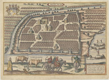
Duval - Pair: Map of Georgia & Map of Moscow, RussiaTrillium Antique Prints & Rare Books4.5(30)See Sold PriceFeb 24, 2024
Duval - Pair: Map of India & Map of MaldivesTrillium Antique Prints & Rare Books4.5(30)See Sold PriceFeb 24, 2024
Linnaeus - Pair: Bengal & Golden OriolesTrillium Antique Prints & Rare Books4.5(30)See Sold PriceFeb 24, 2024
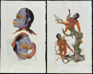
Donovan - Pair: Rufous Orang Outang (Orangutan): Wild Man of the Woods & Two Studes of the HeadTrillium Antique Prints & Rare Books4.5(30)See Sold PriceFeb 24, 2024
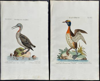
Edwards & Seligmann - Pair of Diver or Loon EngravingsTrillium Antique Prints & Rare Books4.5(30)See Sold PriceFeb 24, 2024
Audubon, NYSE Best Watercolor Ed - Pair: Brown Pelican & Reddish EgretTrillium Antique Prints & Rare Books4.5(30)See Sold PriceFeb 24, 2024
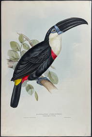
Gould - Natterer's Aracari or ToucanTrillium Antique Prints & Rare Books4.5(30)See Sold PriceFeb 24, 2024
1816 MAP NORTHERN PART OF RUSSIA or MUSCOVY in EUROPE copper engraving ANTIQUEJasper524.5(9.8k)See Sold PriceFeb 27, 2024
1758 MAP PARTIE DE LA MER GLACIALE contenants La Nouvelle Zemble RUSSIA antiqueJasper524.5(9.8k)See Sold PriceFeb 27, 2024
Blackie (Pub) 1882 Pair of Folio Maps. Italy - North & SouthAlbion Auctions4.6(336)See Sold PriceMar 01, 2024
Paterson & Mogg 1822 Pair of British Road Maps. Isle of Thanet & WightAlbion Auctions4.6(336)See Sold PriceMar 01, 2024
Paterson & Mogg 1822 Pair of British Road Maps. Rye, Eastbourne, SouthamptonAlbion Auctions4.6(336)See Sold PriceMar 01, 2024
Paterson & Mogg 1822 Pair of British Road Maps. Deal, Hythe, Shoreham, ChichesterAlbion Auctions4.6(336)See Sold PriceMar 01, 2024