Rigobert Bonne Map of Saxony Germany 1787MAP - CARTE DE LA PARTIE MERIODIONALE DU CERCLE DE HAUTE SAXE ( SXAONY GERMANY - ORIGINAL COLOR ) ,1787 ,15" x 12". ,Bonne,,This charming map is in very good condition, full borders as published, foldSee Sold Price
RIGOBERT BONNE 1787 Original Colored Map Germany & Region 15" x 12"Bonne, Rigobert : MAP - CARTE DE LA PARTIE MERIODIONALE DU CERCLE DE HAUTE SAXE ( SAXONY GERMANY - ORIGINAL COLOR ) Published in 1787, Measures 15" x 12". mapped by Rigobert Bonne. This charming map iSee Sold Price
SoldFramed map, Rigobert Bonne, Northeastern US, 1787Framed handcolored map, Rigobert Bonne, Carte De La Partie Nord, Des Etats Unis, de l' Amerique Septentrionale, Northeastern United States, from Raynal's ''Atlas d.les Deux Indes'', Geneva, J.L. PelleSee Sold Price
Sold(MAP) BONNE, RIGOBERT. [Paris, c. 1787].(MAP) BONNE, RIGOBERT Amerique Septentrionale, [Paris, c. 1787]. Hand-colored engraved map of Northern and Central America. Framed and matted. 11 x 16 inches.See Sold Price
Sold1787 HAND COLORED LES ISLES ANTILLESAntique 1787 Hand Colored Map - Les Isles Antilles et le Golfe Du Mexique [Bermuda Inset] By Rigobert Bonne. Detailed map of the Caribbean, Florida, Gulf Coast and Central America, showing islands, cuSee Sold Price
SoldAmerique Meridionale Map, South America, R.Bonne 1787Framed original map of South America, 1787. Cartographer: Rigobert Bonne. Amerique Meridionale Map. Copperplate engraved map. Dimension: framed: 20.25"x 15.75"; sight: 14"x 10" Condition: good framedSee Sold Price
Sold4 South America maps: Bonne, c.1780-87[South America]. Rigobert Bonne. 4 Maps. Very good condition, hand-colored. ++ Carte Du Paraguay Et partie des Pays adjacants. St. Jacques, 1782 [c.1787]. 17 1/4 x 13 1/8 in. Lower right corner lightlSee Sold Price
1787 Bonne Map of French GuyaneA map of French Guyana "La Guyane Francoise Avec Partie De La Guyane Hollandoise", by Rigobert Bonne, printed at Paris 1787. Fine condition, measures 10 x 14". Cenrtral fold as issued. Reserve: $30.00See Sold Price
1787 Bonne Map of French GuyaneA map of French Guyana "La Guyane Francoise Avec Partie De La Guyane Hollandoise", by Rigobert Bonne, printed at Paris 1787. Fine condition, measures 10 x 14". Cenrtral fold as issued. Reserve: $40.00See Sold Price
Bonne: 1787 Map of Martinique and GuadeloupeReserve Reduced! Title of Map: Isle de la Martinique/Isles de la Guadeloupe, de Marie Galante, de la Desirade, et celles des Saintes. Cartographer: Rigobert Bonne Place/Date: Paris / 1787 Size: 14" xSee Sold Price
1787 Bonne Map of French GuyaneA map of French Guyana "La Guyane Francoise Avec Partie De La Guyane Hollandoise", by Rigobert Bonne, printed at Paris 1787. Fine condition, measures 10 x 14". Cenrtral fold as issued. Reserve: $30.00See Sold Price
1787 Bonne Map of French GuyaneA map of French Guyana "La Guyane Francoise Avec Partie De La Guyane Hollandoise", by Rigobert Bonne, printed at Paris 1787. Fine condition, measures 10 x 14". Cenrtral fold as issued. Reserve: $40.00See Sold Price
SoldBonne: Antique Map of Asia, 1787Item: Map of Asia 1787 Bonne Etching On Copper Very beautiful map of Asia Author: Bonne Rigobert (1727-1794) Atlas: Atlas de toutes parties connues du globe terrestre... Date: 1787 Technique: etchingSee Sold Price
SoldTwo Maps by Rigobert Bonne (1727-1794, Paris),Two Maps by Rigobert Bonne (1727-1794, Paris), "Amerique Septentrionle (N. America)," 1787, matted and mounted, hand colored; together with "Les Petites Antilles ou les Iles du Vent," Petitsem- H. - 1See Sold Price
SoldBonne: Antique Map of North America, 1787Very beautiful map of North America Author: Bonne, Rigobert (1727-1794). Atlas: Atlas de toutes parties connues du globe terrestre... Date: 1787 Technique: etching on copper Leaf Dimension: 38x30 cm (See Sold Price
SoldBonne: Antique Map of Tartary China Korea Japan, 1787Item: Map of Tartary China Korea Japan 1787 Bonne Etching On Copper Very beautiful map of Tartary, China, Korea and Japan Author: Bonne Rigobert (1727-1794) Atlas: Atlas de toutes parties connues du gSee Sold Price
Bonne: Antique Map of Tartary China Korea Japan, 1787Item: Map of Tartary China Korea Japan 1787 Bonne Etching On Copper Very beautiful map of Tartary, China, Korea and Japan Author: Bonne Rigobert (1727-1794) Atlas: Atlas de toutes parties connues du gSee Sold Price
SoldMAP, New Zealand, BonneNew Zealand. Rigobert Bonne, Carte de la Nouvelle Zeelande, from Atlas Encyclopedique, 1787 (circa). Hand Color. This uncommon, detailed chart of the islands shows the track of Captain Cook's first voSee Sold Price
MAP - Martinique & Guadeloupe. BonneMartinique & Guadeloupe. Rigobert Bonne, Isle de la Martinique [on sheet with] Isles de la Guadeloupe, de Marie Galante, de la Desirade, et Celles des Saintes, 1787 (circa). Hand Color. This attractivSee Sold Price
2 18TH C. BONNE MAPS OF THE SOUTH ATLANTIC ISLANDSTwo hand colored maps of the South Atlantic Islands, comprising Rigobert Bonne (French 1727-1794) "Isles Maidenland, de Hawkins, et le Detroit De Fakland...", circa 1787, etching on paper showing CommSee Sold Price
SoldMAPS - Southern Alaska. BonneSouthern Alaska. Rigobert Bonne, [Lot of 2] Carte de la Riviere de Cook, dans la Partie N.O. de l'Amerique [and] Amer. Sep. Partie de l'Amerique Russe. No. 13, 1787-1827 (circa). A. Carte de la RivierSee Sold Price
SoldRIGOBERT BONNE - Isles Canaries. Paris, 1787RIGOBERT BONNE Racourt, France 1727 - 1795 NICOLAS DESMAREST France 1725 - 1815 Isles Canaries. Paris, 1787 Colored copper engraving Signed, tutulated and dated Size 23.4 x 34.2 cm plate Comes from thSee Sold Price
SoldCharts of Tonga Islands 1780'sHeading: (Pacific Ocean - Tonga) Author: Title: Two engraved charts/maps of Tonga Place Published: Paris & London Publisher: Date Published: 1787 & c.1785 Description: InclSee Sold Price
Sold1760 RIGOBERT BONNE MAP OF CHINABONNE, Rigobert, (1727-1795): l'Empire de la Chine. Paris, ca 1760. Copper engraved, 9'' x 13 1/2'', hand colored. Fine. Matted and framed, 21 1/2'' x 27 1/4''.See Sold Price
17TH C. ANTIQUE MAP SIEGE OF LA ROCHELLE, FRANCE, FRAMEDThomaston Place Auction Galleries4.4(386)See Sold PriceFeb 24, 2024
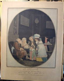
Philibert-Louis Debucourt Original Engraving Le Compliment 1787 VERY RARE!Luis Porretta Fine Arts4.3(10)See Sold PriceMar 02, 2024
AMBROISE TARDIEU c1822 Napoleonic War Map GermanyLuis Porretta Fine Arts4.3(10)See Sold PriceMar 02, 2024
MAP - AMBROISE TARDIEU c1822 Napoleonic Miltary Map GermanyLuis Porretta Fine Arts4.3(10)See Sold PriceMar 02, 2024
RIGOBERT BONNE c1787 Original Colored Map Germany & Region 15" x 12"Luis Porretta Fine Arts4.3(10)See Sold PriceMar 02, 2024
Ampol Three Wheeled Car with Spinning Map Parasol - Tin ToyThe RSL Auction Company4.6(239)See Sold PriceMar 09, 2024
17th Century Hand Colored Engraved Map of GermanyGlobal Auctions Company4.3(36)See Sold PriceMar 03, 2024
18th Century Hess Germany Hand colored Engraved MapGlobal Auctions Company4.3(36)See Sold PriceMar 03, 2024
Meissen Porcelain Large Group H: 10" W: 9" D: 7" GermanyCarstens Galleries4.5(128)See Sold PriceMar 01, 2024
Cooke, George 1801 Antique Map. Germany divided into CirclesAlbion Auctions4.6(336)See Sold PriceMar 01, 2024
1849 Orr & Co. Hand Colored Southern Germany MapMatthew Bullock Auctioneers4.7(1.8k)See Sold PriceMar 02, 2024
1792 OLD INDIA HISTORY ANTIQUE ILLUSTRATED WITH MAPS OF THE EIGHTEENTH CENTURY IN FRENCHNY Elizabeth 4.3(84)See Sold PriceMar 03, 2024
Set of 4 Maps - Netherlands - Seven United Provinces - Germany - Sweden, Denmark, Norway, FinlandProverde Auctions4.3(3)See Sold PriceFeb 28, 2024


![(MAP) BONNE, RIGOBERT. [Paris, c. 1787]. (1 of 1)](https://p1.liveauctioneers.com/197/30916/12134080_1_x.jpg?height=282&quality=70&version=1342619735)