SoldCharts of Tonga Islands 1780'sHeading: (Pacific Ocean - Tonga) Author: Title: Two engraved charts/maps of Tonga Place Published: Paris & London Publisher: Date Published: 1787 & c.1785 Description: InclSee Sold Price
South Pacific – Friendly Islands (Tonga) BritishTitle/Content of Map: South Pacific – Friendly Islands (Tonga) British Admiralty Chart 474, published 1897 Date: 1897 Cartographer: British Admiralty Material/Medium: thick paper Size: standard UnusSee Sold Price
Tonga Islands in the South Pacific British AdmiraltyTitle/Content of Map: Tonga Islands in the South Pacific British Admiralty Chart 968, published 1953 Date: 1953 Cartographer: British Admiralty Material/Medium: thick paper Size: standard Nice, littleSee Sold Price
Tonga Islands in the South Pacific British AdmiraltyNice, little coulored and unused sea chart of Iles Walls, Iles de Horne, Ile Futuna and other islands in the South pacific. Authentic, very detailed sea chart, no modern copy. On thick paper, folded aSee Sold Price
South Pacific – Friendly Islands (Tonga) BritishUnused, detailed sea chart of the North East coast of the Tonga or Friendly Islands. The first surveys are from 1895 by Captain A.F. Balfour on the ship Penguin. Tidal information is mentioned. AuthenSee Sold Price
Antique Map Print of Oceania - Map of Tonga - Friendly Islands - James CookTitle/Content: Antique Map Print of Oceania - Map of Tonga - Friendly Islands - James Cook Date: 1785 Material: Paper Dimensions: 10” x 17” inches / 26 cm x 42 cm Description: Chart of theSee Sold Price
SoldChart of the Island of Tongataboo, 1799A framed hand-coloured original antique map of Tongataboo Island - Tongatapu Island, Tonga- was engraved by Thomas Foot and published by T. Gillet in 1799. A missionary voyage to the Southern PacificSee Sold Price
Original Imray & Son Chart of South Pacific, 1876Nautical chart of the South Pacific from James Imray & Son, 1875, but stamped 1876. Details include New Zealand, Tonga Isles, Cook Islands, Tuobouai Archipelago, Tuamoti Archipelago, Fiji and more. UnSee Sold Price
Original Imray & Son Chart of South Pacific, 1876Nautical chart of the South Pacific from James Imray & Son, 1875, but stamped 1876. Details include New Zealand, Tonga Isles, Cook Islands, Tuobouai Archipelago, Tuamoti Archipelago, Fiji and more. UnSee Sold Price
Bonne: Antique Map of Island of Jamaica, 1780Title/Content of Map: Carte de l'Isle de la Jamaique Date Printed: 1780 Cartographer: Bonne, Rigobert Size (inches): 12 x 8 Modern watercolor Attractive hand-colored antique chart by Bonne ca. 1780. HSee Sold Price
A Chart of the Island of Jamaica with its Bays, Harbours… by John Lodge 1780 mapTITLE/CONTENT OF MAP: 'A Chart of the Island of Jamaica, with its Bays, Harbours, Rocks, Soundings, &c.' DATE PRINTED: August 1780 IMAGE SIZE: Approx 27.0 x 38.0cm, 10.5 x 15 inches (Large); Please noSee Sold Price
A Chart of the Island of Jamaica with its Bays, Harbours… by John Lodge 1780 mapTITLE/CONTENT OF MAP: 'A Chart of the Island of Jamaica, with its Bays, Harbours, Rocks, Soundings, &c.' DATE PRINTED: August 1780 IMAGE SIZE: Approx 27.0 x 38.0cm, 10.5 x 15 inches (Large); Please noSee Sold Price
SoldMAP, Hawaii, BonneHawaii. Rigobert Bonne, Carte des Isles Sandwich, 1780 (circa). Hand Color. This handsome copper-engraved chart details the Hawaiian Islands. The track of Cook's voyages of 1778 and 1779 are charted tSee Sold Price
SoldAn Account of the Natives of the Tonga Islands.[Tonga] John Martin. AN ACCOUNT OF THE NATIVES OF THE TONGA ISLANDS… 2 Vols. Lon: John Muray, 1818. 2nd ed. 2 plates (frontis & folding map), a few pages with printed musical score. Vol I: lvi, 444See Sold Price
Bonne: Antique Map of British West Indies Islands, 1780Title/Content of Map: 'Supplement pour les Isles Antilles Extrait des Cartes Angloises' A map of (predominantly) British West Indian islands, including The Virgin Islands (present-day British, US & SpSee Sold Price
SoldNatives of the Tonga Islands, 1818Martin, John. AN ACCOUNT OF THE NATIVES OF THE TONGA ISLANDS. London: John Murray, 1818. 2nd ed. 2 v. set, 8vo. lvi, 444; [4], 344, [148] pp., + frontispiece and folding map; a couple of preface leaveSee Sold Price
SoldOCEANIC FAN, 19TH C FROM TONGA ISLANDS, GREATORIGINAL PAINT. 17" HIGH, 25" WIDE. PROVENANCE: FAIRHAVEN COLONIAL CLUB.See Sold Price
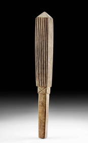
SoldA FINE QUALITY POLYNESIAN FIGHTING CLUB, TONGA ISLANDSA FINE QUALITY POLYNESIAN FIGHTING CLUB, TONGA ISLANDS the heavy hardwood club of slightly tapering ovoid form with finely carved chequered handle and inset marine ivory star to the butt, good colourSee Sold Price
Bonne: Antique Map of Madeira & Canary Islands, 1780Carte des Isles Canaries The detailed Canary Islands map, with Madeira and Porto Santo to the north, from Bonne's Atlas de Toutes les Parties Connues du Monde. Cartographer: Bonne Place & Date: ParisSee Sold Price
SoldA POLYNESIAN HARDWOOD CLUB, TONGA ISLANDS, 19TH CENTURYA POLYNESIAN HARDWOOD CLUB, TONGA ISLANDS, 19TH CENTURY of slightly tapering cylindrical form, carved with horizontal bands of geometric patterns (small chips), the base fitted with a later loop for sSee Sold Price
SoldMartin Tonga IslandsMartin (John) An Account of the Natives of the Tonga Islands,2 vol. in 1, third edition, engraved frontispieces and folding map, offsetting, large ink stamps to titles, occasional foxing, contSee Sold Price
Large 18th C. Tonga Islands Wood Feast Bowl ex-deRoucheOceania, Polynesia, Tonga Islands, ca. 18th to 19th century CE. A massive wooden feast bowl, with a long, low profile, made using a stone adze. The surface has a rich patina and signs of use on its inSee Sold Price
Sold[TONGA ISLANDS].[TONGA ISLANDS]. William Mariner. An Account Of The Natives Of The Tonga Islands, In The South Pacific Ocean. With an original Grammar and Vocabulary of their Language. 2 Vols. Edin: Constable and Co.See Sold Price
Large 18th C. Tonga Islands Wood Feast Bowl ex-deRoucheOceania, Polynesia, Tonga Islands, ca. 18th to 19th century CE. A massive wooden feast bowl, with a long, low profile, made using a stone adze. The surface has a rich patina and signs of use on its inSee Sold Price
LATE 18TH C. VERY LARGE CHART OF NORTHEAST CANADA BY DES BARRES (1721-1824), 1780, FRAMEDThomaston Place Auction Galleries4.4(393)See Sold PriceFeb 24, 2024
CHART "LONG ISLAND SOUND FROM NEW YORK TO MONTOCK POINT ..." New York, 1830 21" x 77" sight. FramedEldred's4.7(419)See Sold PriceFeb 27, 2024
CHART "SOUTHERN COAST OF LONG ISLAND FROM MONTAUK POINT TO EAST HAMPTON" Circa 1877 11.25" x 22.75"Eldred's4.7(419)See Sold PriceFeb 27, 2024
1780 July 2 $4 Rhode Island Colonial Note RI-285 PMG AU58 IssuedMynt Auctions4.6(697)See Sold PriceFeb 24, 2024
1780 July 2 $20 Rhode Island Colonial Note RI-289 PMG CU63 IssuedMynt Auctions4.6(697)See Sold PriceFeb 24, 2024
July 2 $2 Rhode Island Colonial Note 1780 RI-283 PMG AU58 EPQMynt Auctions4.6(697)See Sold PriceFeb 25, 2024
1780 July 2 $7 Rhode Island Colonial Note RI-287 PMG AU53 IssuedMynt Auctions4.6(697)See Sold PriceFeb 26, 2024
July 2 $5 Rhode Island Colonial Note 1780 RI-286 PMG CH63 EPQMynt Auctions4.6(697)See Sold PriceFeb 27, 2024
July 2 $5 Rhode Island Colonial 1780 RI-286 CH New PCGS 64PPQMynt Auctions4.6(697)See Sold PriceFeb 28, 2024
1764 Bellin Map of Lesser Antilles Northern Portion -- Petites Antilles ou Isles du Vent 3e. Partie.Jasper524.5(9.9k)See Sold PriceFeb 27, 2024
West Indies Windward Lesser Antilles. Martinique (Belonging to France)Jasper524.5(9.9k)See Sold PriceFeb 27, 2024
Partie Occidentale de l'Ancien Continent… W Africa Macaronesia. BONNE 1780 mapJasper524.5(9.9k)See Sold PriceFeb 28, 2024
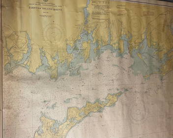
CHART: UNITED STATES - EAST COAST/ RHODE ISLAND - CONNECTICUT - NEW YORK/ Fishers IslandChurchill Galleries3.7(217)See Sold PriceFeb 26, 2024
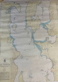
CHART: U.S LAKE SURVEYS/ LAKE CHAMPLAIN/ CUMBERLAND HEAD, NY and SAVAGE ISLAND, VT. TO FOUR BROTHERSChurchill Galleries3.7(217)See Sold PriceFeb 26, 2024
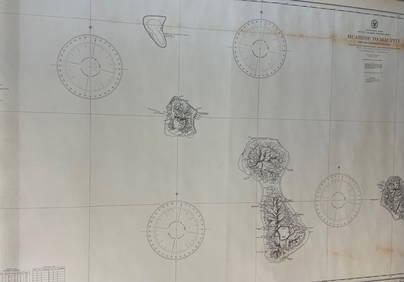
CHART: South Pacific Ocean / SOCIETY ISLANDS - WESTERN GROUP/ HUAHINE TO MAUPITI With theChurchill Galleries3.7(217)See Sold PriceFeb 26, 2024
James Cook - Map of the Friendly Isles - Tonga IslandsProverde Auctions4.3(3)See Sold PriceFeb 28, 2024