ATLAS of ANTIENT GEOGRAPHY by SAMUEL BUTLER 1843John McInnis Auctioneers,LLC4.6(502)See Sold PriceFeb 24, 2024
18TH C. ANTIQUE MAP: FRENCH & INDIAN WAR, FRAMEDThomaston Place Auction Galleries4.4(386)See Sold PriceFeb 24, 2024
Rand McNally Railroad Map Cabinet w/ 21 Railroad MapsRail & Road Auctions4.6(165)See Sold PriceMar 08, 2024
Keith Haring - Ink on New York Map, Best Buddies, Inscribed, Signed, and DatedSapphire Auction Gallery4(67)See Sold PriceMar 02, 2024
LATE 17TH C. FRENCH MAP OF THE NEW WORLD BY ALEXIS-HUBERT JAILLOT (1632-1712)Thomaston Place Auction Galleries4.4(386)See Sold PriceFeb 24, 2024
Central Railroad of New Jersey Map of Sandy Hook Route-ca. 1903JM Hobby Supply and Railroad Artifact Auctions4.4(126)See Sold PriceFeb 24, 2024
Lot of Six Mixed Atlas Box Cars-HO Scale-New in BoxJM Hobby Supply and Railroad Artifact Auctions4.4(126)See Sold PriceFeb 25, 2024
Rand McNally/Santa Fe Railroad Map of Iowa-1912JM Hobby Supply and Railroad Artifact Auctions4.4(126)See Sold PriceFeb 24, 2024
NICOLAES VISSCHER (NETHERLANDS, 1618-1709) MAP OF THE NEW WORLDThomaston Place Auction Galleries4.4(386)See Sold PriceFeb 24, 2024
17TH C. WORLD MAP BY NICOLAES VISSCHER (NETHERLANDS, 1618-1709)Thomaston Place Auction Galleries4.4(386)See Sold PriceFeb 24, 2024
Lot of Six Mixed Atlas Cabooses-HO Scale-New in BoxJM Hobby Supply and Railroad Artifact Auctions4.4(126)See Sold PriceFeb 25, 2024
SoldBonne: Antique Map of Tartary China Korea Japan, 1787Item: Map of Tartary China Korea Japan 1787 Bonne Etching On Copper Very beautiful map of Tartary, China, Korea and Japan Author: Bonne Rigobert (1727-1794) Atlas: Atlas de toutes parties connues du gSee Sold Price
Bonne: Antique Map of Tartary China Korea Japan, 1787Item: Map of Tartary China Korea Japan 1787 Bonne Etching On Copper Very beautiful map of Tartary, China, Korea and Japan Author: Bonne Rigobert (1727-1794) Atlas: Atlas de toutes parties connues du gSee Sold Price
SoldMAP, China, Korea & Japan, Bonne/LattreChina, Korea & Japan. Bonne/Lattre, L'Empire de la Chine d'Apres l'Atlas Chinois, avec les Isles du Japon, from Atlas Moderne, 1787 (circa). Hand Color. Beautifully engraved, decorative map of the ChiSee Sold Price
Asie. Antique map of Asia. Persia China Tartary. BONNE 1787 oldTITLE/CONTENT OF MAP: Asie [Asia] DATE PRINTED: 1787 IMAGE SIZE: Approx 24.5 x 36.0cm, 9.5 x 14 inches (Large); Please note that this is a folding map. TYPE: Antique 18th century copperplate map CONDISee Sold Price
Tartarie Chinoise, Royaume de Corée &… Japon. China Korea Japan. BONNE 1788 mapTITLE/CONTENT OF MAP: Tartarie Chinoise, Royaume de Corée et Isles du Japon [Chinese Tartary, The Kingdom of Korea and the islands of Japan] DATE PRINTED: 1788 IMAGE SIZE: Approx 24.5 x 36.5cm, 9See Sold Price
Tartarie Chinoise, Royaume de Corée &… Japon. China Korea Japan. BONNE 1790 mapTITLE/CONTENT OF MAP: Tartarie Chinoise, Royaume de Corée et Isles du Japon [Chinese Tartary, The Kingdom of Korea and the islands of Japan] DATE PRINTED: 1790 IMAGE SIZE: Approx 24.5 x 36.5cm, 9See Sold Price
Tartarie Chinoise, Royaume de Corée &… Japon. China Korea Japan. BONNE 1790 mapTITLE/CONTENT OF MAP: Tartarie Chinoise, Royaume de Corée et Isles du Japon [Chinese Tartary, The Kingdom of Korea and the islands of Japan] DATE PRINTED: 1790 IMAGE SIZE: Approx 24.5 x 36.5cm, 9See Sold Price
Tartarie Chinoise, Royaume de Corée &… Japon. China Korea Japan. BONNE 1788 mapTITLE/CONTENT OF MAP: Tartarie Chinoise, Royaume de Corée et Isles du Japon [Chinese Tartary, The Kingdom of Korea and the islands of Japan] DATE PRINTED: 1788 IMAGE SIZE: Approx 24.5 x 36.5cm, 9See Sold Price
Original Antique Map - China - Korea - Japan - 19th Century - East Asia - LapieA fine first edition example of M. Lapie's 1832 map of the Chinese empire and Japan. The map covers all of China, Korea, and Japan from Asiatic Russia to India and the Sea of China and from IndependenSee Sold Price
SoldFRENCH BONNE MAP OF CHINA, KOREA & JAPAN, 18TH C.Framed engraving with hand coloring on paper, map of China, Korea, and Japan, "Empire De La Chine, Rme De Coree et Isles Du Japon," Rigobert Bonne (French, 1727-1794) cartographer, engraved by PietroSee Sold Price
SoldBonne map of China, Korea & Japan c.1780Title: Empire de la Chine, Rme de Corée et Isles du Japon Author: Bonne, Rigobert Description: Copper-engraved map, hand-colored (later). 23.5x34.5 cm. (9¼x13½"); hinged to mat, framed under plexigSee Sold Price
Sold1640 China Veteribus Sinarum Regio nunc Incolis TameBy: Willem Johannes BlaeuDate: 1640 (circa) AmsterdamDimensions: 16 x 19.5 inches (40.7 x 49.5 cm)This is an authentic antique map of China, Korea, and Japan by the Blaeu Family. The map was publishedSee Sold Price
Bonne: Antique Map of Chinese Empire Korea & Japan 1780Map: Empire De La Chine, Rme. De Coree Et Isles Du Japon. Publication Date: 1780 Cartographer: BONNE, RIGOBERT Publisher: R. BONNE 1780 PARIS Size: Quarto – 9.25 H x 13.50 W Inches Par M. Bonne... SSee Sold Price
Antique Map - Asia - China Japan Korea Taiwan Vietnam - Philipp Cluver 1701Title/Artist: Antique Map - Asia - China Japan Korea Taiwan Vietnam - Philipp Cluver 1701 Date/Period: 1701 Material: Paper Dimensions: 15 cm x 13 cm Description: A detailed small map from ”IntrSee Sold Price
Petermann: Antique Map of Korea, China, Japan 1875CHINA KOREA UND JAPAN Beatiful map of China Korea and Japan of 1875 circa coloured by hand with aquarello painting. Author: Von A. Petermann Date: 1875 circa Technique: Copper etching Leaf Dimension:See Sold Price
SoldFramed large antique map of China, Japan and KoreFramed large antique map of China, Japan and Korea. Hand-colored copper-plate engraving. Dutch map. Circa 17th C, possibly earlier by Jodocus Hondius, from Hondius' Gerardi Mercatoris Atlas, publishedSee Sold Price
Map China Korea Japan 1875 coloured PetermannCHINA KOREA UND JAPAN Beatiful map of China Korea and Japan of 1875 circa coloured by hand with aquarello painting. Author: Von A. Petermann Date: 1875 circa Technique: Copper etching Leaf Dimension:See Sold Price
Original Antique Map of Asia - China - Japan - 19th Century - East Asia - LapieA fine first edition example of M. Lapie's 1832 map of the Chinese empire and Japan. The map covers all of China, Korea, and Japan from Asiatic Russia to India and the Sea of China and from IndependenSee Sold Price
Antique Map of East Asia - China - Japan - 19th Century - Korea - Central AsiaA fine first edition example of M. Lapie's 1832 map of the Chinese empire and Japan. The map covers all of China, Korea, and Japan from Asiatic Russia to India and the Sea of China and from IndependenSee Sold Price
EAST ASIA China Japan Korea Formosa Taiwan JOHNSTON 1901 old antique map chartTITLE/CONTENT OF MAP: 'China and Japan' DATE PRINTED: 1901 IMAGE SIZE: Approx 36.5 x 46.5cm, 14.25 x 18.25 inches (Large); Please note that this is a folding map. TYPE: Antique colour map CONDITION: GSee Sold Price
EAST ASIA China Japan Korea Formosa Taiwan JOHNSTON 1901 old antique map chartTITLE/CONTENT OF MAP: 'China and Japan' DATE PRINTED: 1901 IMAGE SIZE: Approx 36.5 x 46.5cm, 14.25 x 18.25 inches (Large); Please note that this is a folding map. TYPE: Antique colour map CONDITION: GSee Sold Price
ASIA POLITICAL. Persia Siam Hejaz China Japan Korea Turkestan. JOHNSTON 1910 mapTITLE/CONTENT OF MAP: Asia [Political] DATE PRINTED: 1910 IMAGE SIZE: Approx 21.5 x 27.5cm, 8.25 x 10.75 inches (Medium) TYPE: Colour antique map CONDITION: Good; suitable for framing. However, pleaseSee Sold Price
ASIAN ANGLICAN CHURCH DIOCESES. India Ceylon Burma Japan Korea China 1897 mapTITLE/CONTENT OF MAP: 'The Anglican Dioceses in Asia 1897' DATE PRINTED: 1897 IMAGE SIZE: Approx 19.5 x 24.0cm, 7.5 x 9.5 inches (Medium) TYPE: Coloured antique map CONDITION: Good; suitable for framiSee Sold Price
EAST ASIA. Eastern China Central Japan Korea. BARTHOLOMEW 1898 old antique mapTITLE/CONTENT OF MAP: 'Eastern China & Central Japan; Inset map of Tokio; Tozando' DATE PRINTED: 1898 IMAGE SIZE: Approx 43.5 x 32.5cm, 17 x 12.75 inches (Large); Please note that this is a folding maSee Sold Price
A Fine RARE Antique Woven ikat Pictorial TextilePremier Auction Galleries4.3(329)See Sold PriceMar 09, 2024
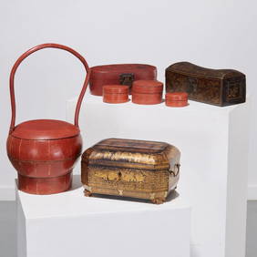
Famous Dealer Spink 1997 Form & Function Furniture from China Japan and KoreaSunburst Auction4.4(19)See Sold PriceFeb 24, 2024
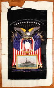
(Early 20th c) MEMENTO of the U.S.S. MONTANAJohn McInnis Auctioneers,LLC4.6(502)See Sold PriceFeb 25, 2024
Vaillant - Hawaii: Stranding in the Sandwich Islands (Echouage aux Iles Sandwich). 43Trillium Antique Prints & Rare Books4.5(30)See Sold PriceFeb 24, 2024
Vaillant - Kealakekua Bay, Hawaii (Village de Kearakekoua, Iles Sandwich). 44Trillium Antique Prints & Rare Books4.5(30)See Sold PriceFeb 24, 2024
Vaillant - Honolulu, Hawaii (Vue de Honolulu, Iles Sandwich). 45Trillium Antique Prints & Rare Books4.5(30)See Sold PriceFeb 24, 2024
Vaillant - Hawaiian Dance (Scene de Danse aux Iles Sandwich). 42Trillium Antique Prints & Rare Books4.5(30)See Sold PriceFeb 24, 2024
1749 MAP CARTE DE LA TARTARIE ORIENTALE RUSSIA & CHINA antique EASTERN TARTARYJasper524.5(9.8k)See Sold PriceFeb 27, 2024
Perry, Matthew C. 1856 Large Map. Shah Bay, Lew Chew I. JapanAlbion Auctions4.6(336)See Sold PriceMar 01, 2024
ANTIQUE ILLUSTRATED HANDBOOK OF GEOGRAPHY AND TRAVEL IN ASIA, VOLUME 2, 1896NY Elizabeth 4.3(84)See Sold PriceMar 03, 2024
Henri Plon - Set of 10 Prints - Ethnography - Pekin - Japan - Anthropologic LithographyProverde Auctions4.3(3)See Sold PriceFeb 28, 2024
Henri Plon - Set of 20 topographical prints depicting Asia - Japan - China - Religious building -Proverde Auctions4.3(3)See Sold PriceFeb 28, 2024