ATLAS of ANTIENT GEOGRAPHY by SAMUEL BUTLER 1843John McInnis Auctioneers,LLC4.5(505)See Sold PriceFeb 24, 2024
18TH C. ANTIQUE MAP: FRENCH & INDIAN WAR, FRAMEDThomaston Place Auction Galleries4.4(393)See Sold PriceFeb 24, 2024
Rand McNally Railroad Map Cabinet w/ 21 Railroad MapsRail & Road Auctions4.6(165)See Sold PriceMar 08, 2024
Keith Haring - Ink on New York Map, Best Buddies, Inscribed, Signed, and DatedSapphire Auction Gallery4(67)See Sold PriceMar 02, 2024
LATE 17TH C. FRENCH MAP OF THE NEW WORLD BY ALEXIS-HUBERT JAILLOT (1632-1712)Thomaston Place Auction Galleries4.4(393)See Sold PriceFeb 24, 2024
Central Railroad of New Jersey Map of Sandy Hook Route-ca. 1903JM Hobby Supply and Railroad Artifact Auctions4.4(127)See Sold PriceFeb 24, 2024
Lot of Six Mixed Atlas Box Cars-HO Scale-New in BoxJM Hobby Supply and Railroad Artifact Auctions4.4(127)See Sold PriceFeb 25, 2024
Rand McNally/Santa Fe Railroad Map of Iowa-1912JM Hobby Supply and Railroad Artifact Auctions4.4(127)See Sold PriceFeb 24, 2024
NICOLAES VISSCHER (NETHERLANDS, 1618-1709) MAP OF THE NEW WORLDThomaston Place Auction Galleries4.4(393)See Sold PriceFeb 24, 2024
17TH C. WORLD MAP BY NICOLAES VISSCHER (NETHERLANDS, 1618-1709)Thomaston Place Auction Galleries4.4(393)See Sold PriceFeb 24, 2024
Lot of Six Mixed Atlas Cabooses-HO Scale-New in BoxJM Hobby Supply and Railroad Artifact Auctions4.4(127)See Sold PriceFeb 25, 2024
SoldPossibly the largest published map of Long IslandHeading: Author: Colton, G.W. and C.B Title: Colton's New Map of Long Island Place Published: New York Publisher:Colton & Co. Date Published: 1882 Description: Folding map,See Sold Price
Map of Long Island, 1905Map: Map of Long Island Maker: Geo. H. Walker & Co., Hyde & CoDate: 1905 Size: Folio, 17.50 inches high x 22.75 inches wide "Based on the Map of Long Island , published and copyrighted 1896 by Hyde &See Sold Price
Sold1855 ENGRAVED PRINT LONG ISLAND SOUND SURVEY MAPA very detailed, large engraved print map of Long Island Sound, published in 1855. The drawing is by Fairfax, Wampler & Gluck. The engraving is by Siebert, Knight, Rolle, & McCoy. Measurements: EngravSee Sold Price
Long Island Sound (Western Sheet)Title/Content of Map: Long Island Sound (Western Sheet) Cartographer: U.S. COAST SURVEY/F. R. HASSLER Date: 1866 Publisher: GPO Size: 24.5Height - 35Width "Published in 1855" New York and ConnecticutSee Sold Price
Long Island Sound (Western Sheet)Title/Content of Map: Long Island Sound (Western Sheet) Date: 1866 Cartographer: U.S. COAST SURVEY/F. R. HASSLER Publisher: GPO Size: 24.5Height - 35Width Published in 1855 New York and Connecticut coSee Sold Price
Sold1830 Map of Long Island SoundFrom New York to Mantock Point; published by E. & G.W. Blunt, NY. Printed in three sheetes 24" x 8 1/2", pressure mounted and framed, 26 1/4" x 84 1/4".See Sold Price
SoldW. Ackerman (20th c.). "Map of Long Island," c. 19W. Ackerman (20th c.). "Map of Long Island," c. 1960s, oil on board, 20 x 24 inches, signed. Possibly painted for the 1964 World's Fair held in Queens, Long Island (fair buildings with banners appearSee Sold Price
SoldVintage Map of Long IslandVintage map of Long Island, drawn by Courtland Smith from data compiled by Richard Foster, published by The Billboard Barn, Southampton, Long Island, printed by Gerson Offset Litho Co., NY. [Sight: 19See Sold Price
SoldU.S. Coast Survey 1853 Map of Long Island, New Jersey"Sketch B Showing the progress of Section No. 2" Electrotype Map Published 1843-65, Washington for "Report of the Superintendent of the U.S. Coast Survey..." Published under the supervision and directSee Sold Price
Sold1776 Long Island Map1776 Revolutionary War era sketch of the country illustrating the late engagement in Long island 13" x (h) x 9" (l) map, published in the Gentleman's Magazine, v.46, Oct 1776. [29] CONDITION: Areas wiSee Sold Price
SoldColton folding map of Long Island 1872Heading: Author: Colton, George Woolworth and Charles B. Colton Title: Map of Long Island and the Southern Part of Connecticut Place Published: New York Publisher:Published by G.W. & C.G. Colton & CoSee Sold Price
Three US Coast Survey Map of Long Island RegionSketch B No. 3, showing the progressive changes in Sandy Hook from 1779 to 1853. Published Washington D.C. 1853, 12 x 11.5 inches. Folds as issued. Sketch B No 2. US Coast Survey of Romer and Flynns SSee Sold Price
Three US Coast Survey Map of Long Island RegionSketch B No. 3, showing the progressive changes in Sandy Hook from 1779 to 1853. Published Washington D.C. 1853, 12 x 11.5 inches. Folds as issued. Sketch B No 2. US Coast Survey of Romer and Flynns SSee Sold Price
SoldMap of Connecticut And Rhode Island 1780This early map is titled 'A New and accurate Map of Connecticut and Rhode Island. from the best Authorities' published in the Universal Magazine in 1780. The map features Long Island Sound and NarragaSee Sold Price
SoldELEVEN MAPS. - unframed.ELEVEN MAPS. United States of America. John Melish, published by Carey & Son, 1820 (17 1/2 x 22) Map of Long Island. De Beers, NY, c. 1840, a fold out map in brown buckram covers (13 x 50 in.). TerraSee Sold Price
SoldRARE 1776 LONG ISLAND MAPFROM THE GENTLEMAN'S MAGAZINE, LONDON, OCTOBER 1776. BEAUTIFUL PERIOD HAND COLORING. FRAMED. IMAGE OF MAP IS APPROX. 13" X 8.5". APPEARS TO POSSIBLY BE LINEN BACKED.See Sold Price
1859 SURVEY MAP OF HEMPSTEAD HARBOR, LONG ISLAND, NEWScarce and detailed engraved map of Hempstead Harbor Long Island published in 1859 by the "Survey of the Coast of the United States" 1:20 000 scale. The plate measures approx. 16.25 x 18 in.See Sold Price
1859 SURVEY MAP OF HEMPSTEAD HARBOR, LONG ISLAND, NEWScarce and detailed engraved map of Hempstead Harbor, Long Island, published in 1859 by the 'Survey of the Coast of the United States', 1:20,000 scale. The plate measures approx. 16.25 x 18 in., withSee Sold Price
SoldBLOCK ISLAND SOUND & APPROACHES CHART MAPSAlso includes chart of Long Island, Shelter Island, and Peconic Bays published in 1967. Two maps of Block Island is dated 1967 and the other is dated 1964. 42" X 35 1/4" $40 - $80 PleSee Sold Price
SoldMap of Eastern Part of Long Island Sound, 1855,Map of Eastern Part of Long Island Sound, 1855, Second edition of 1880 to 1883,Under the direction of F. H. Hassler and published by the United States Coast and Geodetic Survey.Framed dimensions: H: 2See Sold Price
Fire Island & Oak Island, New York, 1902Fire Island & Oak Island, Long Island, New York. Map features Point O'Woods Association, Oak Island in Babylon & Coolier Channel. Original engraving published by E. Belcher Hyde from "Atlas of SuffolkSee Sold Price
SoldEarly MapsLot (2) early unframed maps "WEST INDIES" (London, (E) Published By Charles Wilson..., 26" x 39 1/2"), "LONG ISLAND SOUND" (London, 27 1/4" x 40 1/4").See Sold Price
SoldBridgehampton & Watermill, Long Island, 1902Original engraving published by E. Belcher Hyde from "Atlas of Suffolk County, Long Island, New York," Philadelphia, 1902. Map features family names, historic buildings and railroad routes. DimensionsSee Sold Price
Fire Island & Oak Island Beach, 1902Map of part of Fire Island and Oak Island Beach. Original engraving published by E. Belcher Hyde from "Atlas of Suffolk County, Long Island, New York," Philadelphia, 1902. Map highlights family names,See Sold Price
CHART "LONG ISLAND SOUND FROM NEW YORK TO MONTOCK POINT ..." New York, 1830 21" x 77" sight. FramedEldred's4.7(419)See Sold PriceFeb 27, 2024
Group of Ten Railroad Photographs, Maps, and Prints - New Jersey, Long Island, and New YorkRail & Road Auctions4.6(165)See Sold PriceMar 07, 2024
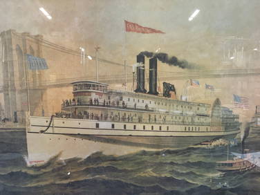
Iron Mountain Of Long Island Sound Litho J GleasonThe Benefit Shop Foundation Inc.4.3(2.9k)See Sold PriceMar 06, 2024
Oyster Bay Long Island NY Vintage Color Reproduction Map 12 x 18Mynt Auctions4.6(697)See Sold PriceFeb 23, 2024
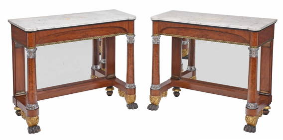
Rare Pair of American Classical Cut Glass Mounted and Gilt Stenciled Burlwood Pier TablesBrunk Auctions4.6(470)See Sold PriceMar 08, 2024
TWO LARGE TRIBAL CARVED WOOD ANIMALS possibly African. Largest 54 cm long. (2)Hannam's Auctioneers Ltd4.3(396)See Sold PriceFeb 27, 2024
Lot of Chinese Jewelry Items Including CloisonneWorld Auction Gallery LLC4.7(264)See Sold PriceMar 10, 2024
3 Sterling Silver & Large Amber Jewelry ItemsWorld Auction Gallery LLC4.7(264)See Sold PriceMar 10, 2024
5 Old Middle Eastern Silver Carved Stone RingsWorld Auction Gallery LLC4.7(264)See Sold PriceMar 10, 2024
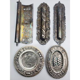
5 Piece Judaica Lot of Sterling Silver ItemsWorld Auction Gallery LLC4.7(264)See Sold PriceMar 10, 2024
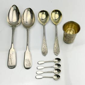
Group Lot of 9 Antique Russian Silver ItemsWorld Auction Gallery LLC4.7(264)See Sold PriceMar 10, 2024
Lot of 3 English Pottery Vases Incl. a MoorcroftWorld Auction Gallery LLC4.7(264)See Sold PriceMar 10, 2024
4 Japanese Cloisonne Vases Along w/ Mini TeapotWorld Auction Gallery LLC4.7(264)See Sold PriceMar 10, 2024