ATLAS of ANTIENT GEOGRAPHY by SAMUEL BUTLER 1843John McInnis Auctioneers,LLC4.6(504)See Sold PriceFeb 24, 2024
18TH C. ANTIQUE MAP: FRENCH & INDIAN WAR, FRAMEDThomaston Place Auction Galleries4.4(389)See Sold PriceFeb 24, 2024
Rand McNally Railroad Map Cabinet w/ 21 Railroad MapsRail & Road Auctions4.6(165)See Sold PriceMar 08, 2024
Keith Haring - Ink on New York Map, Best Buddies, Inscribed, Signed, and DatedSapphire Auction Gallery4.1(67)See Sold PriceMar 02, 2024
LATE 17TH C. FRENCH MAP OF THE NEW WORLD BY ALEXIS-HUBERT JAILLOT (1632-1712)Thomaston Place Auction Galleries4.4(389)See Sold PriceFeb 24, 2024
Central Railroad of New Jersey Map of Sandy Hook Route-ca. 1903JM Hobby Supply and Railroad Artifact Auctions4.4(126)See Sold PriceFeb 24, 2024
Lot of Six Mixed Atlas Box Cars-HO Scale-New in BoxJM Hobby Supply and Railroad Artifact Auctions4.4(126)See Sold PriceFeb 25, 2024
Rand McNally/Santa Fe Railroad Map of Iowa-1912JM Hobby Supply and Railroad Artifact Auctions4.4(126)See Sold PriceFeb 24, 2024
NICOLAES VISSCHER (NETHERLANDS, 1618-1709) MAP OF THE NEW WORLDThomaston Place Auction Galleries4.4(389)See Sold PriceFeb 24, 2024
17TH C. WORLD MAP BY NICOLAES VISSCHER (NETHERLANDS, 1618-1709)Thomaston Place Auction Galleries4.4(389)See Sold PriceFeb 24, 2024
Lot of Six Mixed Atlas Cabooses-HO Scale-New in BoxJM Hobby Supply and Railroad Artifact Auctions4.4(126)See Sold PriceFeb 25, 2024
Portolano style map of the Mediterranean SeaTitle:Portolano style map of the Mediterranean Sea Date/Period: 1744-1748 Materials: Copperplate engraved Dimensions: 24x16”. Map by Emanuel Bowen, published by John Harris in "Navigantium Atque ItiSee Sold Price
Portolano style map of the Mediterranean Sea.Title: Portolano style map of the Mediterranean Sea. Date/Period: 1744-1748 Materials: Copperplate engraved Dimensions: 24x16”. Map by Emanuel Bowen, published by John Harris in "Navigantium Atque ISee Sold Price
SoldPortolano style map of the Mediterranean SeaTitle: Portolano style map of the Mediterranean Sea Date/Period: 1744-1748 Materials: Copperplate engraved Dimensions: 24x16”. Map by Emanuel Bowen, published by John Harris in "Navigantium AtqueSee Sold Price
Portolano style map of the Mediterranean Sea.Title: Portolano style map of the Mediterranean Sea. Date/Period: 1744-1748 Materials: Copperplate engraved Dimensions: 24x16”. By Emanuel Bowen. From John Harris’s a Complete Collection of voyageSee Sold Price
Portolano style map of the Mediterranean Sea.Title: Portolano style map of the Mediterranean Sea. Date/Period: 1744-1748 Materials: Copperplate engraved Dimensions: 24x16”. Map by Emanuel Bowen, published by John Harris in "Navigantium Atque ISee Sold Price
FIRST WORLD WAR: Mediterranean/Aegean Sea. Theatres ofTITLE/CONTENT OF MAP: 'Mediterranean Sea' DATE PRINTED: 1937 IMAGE SIZE: Approx 16.5 x 39.0cm, 6.5 x 15.5 inches (Large); Please note that this is a folding map. TYPE: Vintage colour map CONDITION: GoSee Sold Price
Mediterranean Sea - SardiniaTitle/Content of Map: Mediterranean Sea - Sardinia Date: Cartographer: British Admiralty Material: thick paper Size/Dimensions: 71x104 cm Additional Info: Mediterranean Sea - Sardinia. Lot of two AdmiSee Sold Price
FIRST WORLD WAR. Mediterranean/Aegean Sea. Theatres of operations 1937 old mapTITLE/CONTENT OF MAP: 'Mediterranean Sea' DATE PRINTED: 1937 IMAGE SIZE: Approx 16.5 x 39.0cm, 6.5 x 15.5 inches (Large); Please note that this is a folding map. TYPE: Vintage colour map CONDITION: GoSee Sold Price
Sold1940 MEDITERRANEAN SEA. WW2 Naval Bases. Italian Dodecanese Albania 1940 mapTITLE/CONTENT OF MAP: 'Mediterranean Sea: Communications and Naval Bases' DATE PRINTED: March 1940 IMAGE SIZE: Approx 27.0 x 44.0cm, 10.5 x 17.25 inches (Large) TYPE: Vintage colour map; Scale 1:10,00See Sold Price
WW2 MEDITERRANEAN Naval Bases. Axis Vichy France. Italian Albania 1942 old mapTITLE/CONTENT OF MAP: 'Mediterranean Sea: Communications and Naval Bases' DATE PRINTED: 1942 IMAGE SIZE: Approx 27.5 x 44.5cm, 10.75 x 17.5 inches (Large) TYPE: Vintage colour map CONDITION: Good; suiSee Sold Price
Holland and Belgium. Luxembourg. Benelux. SWANSTON 1860 old antique map chartTITLE/CONTENT OF MAP: 'Mediterranean Sea: Communications and Naval Bases' DATE PRINTED: 1940 IMAGE SIZE: Approx 27.0 x 44.0cm, 10.5 x 17.25 inches (Large) TYPE: Vintage colour map; Scale 1:10,000,000See Sold Price
MEDITERRANEAN SEA 1940. WW2 Naval Bases. Italian Dodecanese Albania 1940 mapTITLE/CONTENT OF MAP: 'Mediterranean Sea: Communications and Naval Bases' DATE PRINTED: 1940 IMAGE SIZE: Approx 27.0 x 44.0cm, 10.5 x 17.25 inches (Large) TYPE: Vintage colour map; Scale 1:10,000,000See Sold Price
1940 MEDITERRANEAN SEA. WW2 Naval Bases. Italian Dodecanese Albania 1940 mapTITLE/CONTENT OF MAP: 'Mediterranean Sea: Communications and Naval Bases' DATE PRINTED: March 1940 IMAGE SIZE: Approx 27.0 x 44.0cm, 10.5 x 17.25 inches (Large) TYPE: Vintage colour map; Scale 1:10,00See Sold Price
FIRST WORLD WAR. Mediterranean/Aegean Sea. Theatres of operations 1937 old mapTITLE/CONTENT OF MAP: 'Mediterranean Sea' DATE PRINTED: 1937 IMAGE SIZE: Approx 16.5 x 39.0cm, 6.5 x 15.5 inches (Large); Please note that this is a folding map. TYPE: Vintage colour map CONDITION: GoSee Sold Price
SoldThomson: Antique Chart Map of Mediterranean Sea, 1817Chart of the Mediterranean Sea. Bay & roads of Marseilles. The harbour of Genoa. Plan of the Rock and Bay of Gibraltar, shewing the position of the combined fleet and attack of the battering ships inSee Sold Price
Mallet: Antique Map of Mediterranean Sea, 1683Title/Content of Map: 'Mer Mediterranee Selon Les Anciens; Partie Orientale de la mer Mediterranee; Partie Occidentale de la Mer Mediterranee' Date Printed: 1683 Image Size: Approx Overall page size 1See Sold Price
SoldPrint of 1559 Map of Mediterranean Sea & EuropePrint of 1559 Map of Mediterranean Sea & EuropeSee Sold Price
Genoa – Mediterranean Sea, Italy - British AdmiraltyTitle/Content of Map: Genoa – Mediterranean Sea, Italy - British Admiralty Chart 157, published 1868 Date: 1868 Cartographer: Brittish Admiralty Material/Medium: thick paper Size: standard 71x104 cmSee Sold Price
Monaco - Mediterranean Sea British Admiralty ChartTitle/Content of Map: Monaco - Mediterranean Sea British Admiralty Chart 3220, published 1902 Date Printed: 1902 Cartographer: British Admiralty Material/Medium: thick paper Size: large, 71x123 cm (28See Sold Price
MEDITERRANEAN PORTS. Marseille Gibraltar Valetta Naples Algiers Piraeus 1903 mapTITLE/CONTENT OF MAP: 'The Mediterranean Sea; Inset maps of Suez Canal; Malaga; Marseilles; Barcelona; Algiers; Venice; Naples; Strait of Gibraltar; Alexandria; Corinth Canal; Pireus; Smyrna; ValettaSee Sold Price
MEDITERRANEAN PORTS. Marseille Gibraltar Valetta Naples Algiers Piraeus 1903 mapTITLE/CONTENT OF MAP: 'The Mediterranean Sea; Inset maps of Suez Canal; Malaga; Marseilles; Barcelona; Algiers; Venice; Naples; Strait of Gibraltar; Alexandria; Corinth Canal; Pireus; Smyrna; ValettaSee Sold Price
SoldWilliam Faden A map of the Mediterranean Sea with theWilliam Faden A map of the Mediterranean Sea with the Adjacent Regions and Sea in Europe, Asia and Africa, hand coloured engraved map, London, March 1st 1785, framedSee Sold Price
Willyams: Antique Map of the Mediterranean Sea, 1802Antique chart of the Mediterranean Sea related to the Battle of the Nile in 1798. A General Chart of the Mediteranean with the tracks of the British Fleet Commanded by Rear Admiral Sir Horatio NelsonSee Sold Price
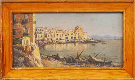
Signed Antique Italian Coastal Mediterranean Sea Original Framed Beach Scene Oil PaintingCurated Gallery Auctions4.6(128)See Sold PriceFeb 25, 2024
Mediterranean Sea coral necklace and 18k gold plated silver claspJasper524.5(9.8k)See Sold PriceFeb 28, 2024
BRONZE SPEAR POINT OR KNIFE FROM MEDITERRANEAN SEA 9 1/2" LONGCarlsen Gallery, Inc.4.6(163)See Sold PriceMar 03, 2024
NORTH & WEST AFRICA. Sahara Niger river 'Zaara ou le Desert'. MALLET 1683 mapJasper524.5(9.8k)See Sold PriceFeb 28, 2024
Stanford, Edward 1901 Large Map. Sea of Marmara. TurkeyAlbion Auctions4.6(341)See Sold PriceMar 01, 2024
Salvador Dali Abraham Lincoln Dalivision Lithograph1 Great Deal Auctions 4.5(262)See Sold PriceMar 09, 2024
Vintage Boho Cowrie Sea Shell Art TrivetsRapid Estate Liquidators and Auction Gallery4.5(1.1k)See Sold PriceFeb 26, 2024
Salvador Dali Abraham Lincoln Dalivision Lithograph1 Great Deal Auctions 4.5(262)See Sold PriceFeb 24, 2024