ATLAS of ANTIENT GEOGRAPHY by SAMUEL BUTLER 1843John McInnis Auctioneers,LLC4.5(505)See Sold PriceFeb 24, 2024
18TH C. ANTIQUE MAP: FRENCH & INDIAN WAR, FRAMEDThomaston Place Auction Galleries4.4(393)See Sold PriceFeb 24, 2024
Rand McNally Railroad Map Cabinet w/ 21 Railroad MapsRail & Road Auctions4.6(165)See Sold PriceMar 08, 2024
Keith Haring - Ink on New York Map, Best Buddies, Inscribed, Signed, and DatedSapphire Auction Gallery4(67)See Sold PriceMar 02, 2024
LATE 17TH C. FRENCH MAP OF THE NEW WORLD BY ALEXIS-HUBERT JAILLOT (1632-1712)Thomaston Place Auction Galleries4.4(393)See Sold PriceFeb 24, 2024
Central Railroad of New Jersey Map of Sandy Hook Route-ca. 1903JM Hobby Supply and Railroad Artifact Auctions4.4(127)See Sold PriceFeb 24, 2024
Lot of Six Mixed Atlas Box Cars-HO Scale-New in BoxJM Hobby Supply and Railroad Artifact Auctions4.4(127)See Sold PriceFeb 25, 2024
Rand McNally/Santa Fe Railroad Map of Iowa-1912JM Hobby Supply and Railroad Artifact Auctions4.4(127)See Sold PriceFeb 24, 2024
NICOLAES VISSCHER (NETHERLANDS, 1618-1709) MAP OF THE NEW WORLDThomaston Place Auction Galleries4.4(393)See Sold PriceFeb 24, 2024
17TH C. WORLD MAP BY NICOLAES VISSCHER (NETHERLANDS, 1618-1709)Thomaston Place Auction Galleries4.4(393)See Sold PriceFeb 24, 2024
Lot of Six Mixed Atlas Cabooses-HO Scale-New in BoxJM Hobby Supply and Railroad Artifact Auctions4.4(127)See Sold PriceFeb 25, 2024
5 - 17/18 C Etchings: Maps, Cities, Isfahan, ect.5 - 17th/18th Century Etchings of Maps, Cities, Battles: an Italian hand-colored folio map with center fold of the Island of Sardinia, "Isola Di Sardegna", A detailed view of Naghsh-e Jahan Square inSee Sold Price
SoldAFTER MANCELLI, "LA VILLA DE MADRID..." ETCHINGAfter Antonio Mancelli (Spanish) "La Villa de Madrid Corte de los Reyes Catolicos de Espana" circa mid 17th century, colored etching depicting a map of Madrid with the court of the Catholic Monarchs oSee Sold Price
SoldA framed antique map of Russia17th/18th Century The map depicting the Caspian Sea and Russia circa 1562 with figural scenes and Latin text 14.5" H x 17.75" WSee Sold Price
SoldLOT OF 9 17TH CENTURY PIRATE TREASURE COINSLot of nine (9) 17th century pirate coins found in the Mediterranean Sea. Range approx. from 1/2" - 1". Age wear and corrosion present. Coins display well and come in small riker mount case. UnauthentSee Sold Price
G. PERELLE (1604-1677), At the gates of a city by the sea, EtchingGabriel Perelle (1604 Vernon or Orléans - 1677 Paris): At the gates of a city by the sea, 17th century, Etching Technique: Etching on Paper Date: 17th century Keywords: before 18th century, BSee Sold Price
Three Vintage Reproduction Antique MapsThree vintage reproductions of old Italian hand-colored etchings of Mediterranean Sea maps, comprising a set of 2 and a single. [Largest: 15 1/2" H x 14 1/2" W].See Sold Price
SoldRare 17th Century Map: Nova Persiae Armeniae NatoliaeHand colored Cornelis Danckerts edition of this decorative and highly desireable map of the region bounded by the Saudi Peninsula, Red Sea, Nile River, Cyprus, Asia Minor, the Gulf of Aden, Indian OceSee Sold Price
SoldAntique Hand Colored Etching Map Willem Janszoon BlaeuAntique Hand Colored Etching Map Willem Janszoon Blaeu "Nova Totius Terrarum Orbis Geographica Ac Hydrographica Tabula auct Guiljelmo Blaeuw" Circa 17th Century or Possibly Later. Good Condition, ObviSee Sold Price
17th Century Hondius Map of theWestern Hemisphere [Septentrio America,] by Jodocus Hondius, published in Amsterdam, first published 1606, from [Mercator's Atlas,] showing North and South America with various sailing vessels and seaSee Sold Price
Sold17th / 18th CENTURY ETCHING DEPICTING WALCHERENMap depicting the Walcheren region of the Netherlands, 37 x 27 cm.See Sold Price
Antique Map 1690 Sea Chart of West Africa Van Keulen Marocco Canary IslandsFine 17th-century sea chart of West Africa, including from the Sierra Leone, Liberia, and Cote d'Ivoire coastlines. The map shows important coastal information that would have been of use to early capSee Sold Price
G. PERELLE (1604-1677), Mediterranean river landscape, EtchingGabriel Perelle (1604 Vernon or Orléans - 1677 Paris): View of a Mediterranean river landscape with hikers as staffage figures, 17th century, Etching Technique: Etching on Paper Date: 17th ceSee Sold Price
SoldEight Vintage MapsMostly depicting the America's, from 17th-19th centuries. Etchings, some hand colored. Largest sight sizeSee Sold Price
SoldMap, Antique, EuropeanFramed hand-colored engraved map, Mittellaendisches Meer [Mediterranean Sea], 18th century, plate: 21.5''h x 30.5''w, overall: 32''h x 40''wSee Sold Price
1662 Geographia Sacra Tabula Prima, Map of Eastern Mediterranean & Middle East17th century. Geographiae Sacrae ex Veteri, et Novo Testamento Desumptae Tabula Prima, quae Totius Orbis Partes Continet. Published in Cartes Generales de Toutes les Parties du Monde, attributed toSee Sold Price
SoldMap and Print AssortmentMap and Print Assortment Approximately (12) pounds of 17th-19th century engravings, etchings and mezzotints, some hand-colored, by various artists including Phillipe de la Rue, Edward Rooker, and AdriSee Sold Price
SoldTHREE 18TH CENTURY MAPS OF EASTERN EUROPETHREE 18TH CENTURY MAPS OF EASTERN EUROPE. Comprising three maps of the countries on the Mediterranean and Black Seas including a 1715 Guillaume Delisle map entitled "Tabula Geographica ProvinciarumSee Sold Price
19th century map of Italy.Map of Italy dated 1863, published by AJ Johnson of New York. Showing Italy, Malta, Sardinia, the Adriatic, Mediterranean and Tuscan Seas. Matted and framed. On sight 23" high x 16" wide. Overall 31"See Sold Price
SoldJohn Seller Cartographer (1665-1705) 17th CenturyJohn Seller Cartographer (1665-1705) 17th Century or Later Map of Virginia and Maryland. Engraved and Hand Colored. John Seller The first English publisher of sea-charts. He was hydrographer to CharleSee Sold Price
Sold17th Century Blaeu s General Map of SpainFine example of Blaeu general map of Spain. Hand colored. Features a large cartouche, two Ships and a sea monster. Frame measures 24 1/4 x 28 1/4 inches. Map measures approximately 15 1/4 x 19 3/4 incSee Sold Price
17th Century Hand Colored Engraved Map of GermanyGlobal Auctions Company4.3(36)See Sold PriceMar 03, 2024
Willem Blaeu, Etc. 17th C. Antiquarian Maps, 2Auctions at Showplace4.6(740)See Sold PriceMar 17, 2024
The Red Sea, Large copper painted in oil from the 17th century, attributable to the workshop orTemplum Fine Art Auctions4.3(8)See Sold PriceFeb 28, 2024
REMBRANDT VAN RIJN (1606-1669) ETCHING TITLED MAN WITH FEATHER BARRETTE - 9.25IN x 10.75IN - 1639The Rug Life4.3(13)See Sold PriceMar 07, 2024
18th century MAP of ARMENIA GEORGIA NATOLIA BLACK SEA ASIA MINOR antiqueJasper524.5(9.9k)See Sold PriceFeb 27, 2024
WEST AFRICA Niger/Gambia rivers tribes towns. 'Pays des Negres'. MALLET 1683 mapJasper524.5(9.9k)See Sold PriceFeb 28, 2024
WEST AFRICA. Guinea. Nigeria Ghana Benin Togo Sierra Leone. MALLET 1683 mapJasper524.5(9.9k)See Sold PriceFeb 28, 2024
WEST CENTRAL AFRICA. Congo Angola Gabon Cameroon Sao Tome. MALLET 1683 old mapJasper524.5(9.9k)See Sold PriceFeb 28, 2024
NORTH AFRICA. 'Biledulgerid', a former North African country. MALLET 1683 mapJasper524.5(9.9k)See Sold PriceFeb 28, 2024
WEST AFRICA/MAGHREB Tribes Garamantes Getgulie 'Ancienne Libye'. MALLET 1683 mapJasper524.5(9.9k)See Sold PriceFeb 28, 2024
NORTH AFRICA. Barbary. Morocco Tunisia Libya Egypt. 'Barbarie'. MALLET 1683 mapJasper524.5(9.9k)See Sold PriceFeb 28, 2024
NORTH AFRICA. Morocco Tunisia Libya. 'Mauritanie'. Malta Melita. MALLET 1683 mapJasper524.5(9.9k)See Sold PriceFeb 28, 2024
NUBIA. 'Nubie'. Nile Valley. Sudan Ethiopia Egypt. MALLET 1683 old antique mapJasper524.5(9.9k)See Sold PriceFeb 28, 2024
SUB-SAHARAN AFRICA. 'Ancienne Ethiopie'. Ancient Ethiopia. MALLET 1683 old mapJasper524.5(9.9k)See Sold PriceFeb 28, 2024
ANTIQUE 1686 OPERA OMNIA BY JOHN LIGHTFOOT TELLIMA BOUND FOLIO WITH ISRAEL MAPNY Elizabeth 4.2(86)See Sold PriceMar 03, 2024
1675: ANTIQUE ILLUSTRATED JULIUS CAESAR MAPS OF ROMAN HISTORYNY Elizabeth 4.2(86)See Sold PriceMar 03, 2024
CURTIUS RUFUS QUINTUS, SIXTEENTH-CENTURY ELZEVIER HISTORIARUM LIBRI W/ MAP 16.33NY Elizabeth 4.2(86)See Sold PriceMar 03, 2024
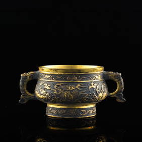
A Chinese gilt-bronze sea dragon-handled incense burner, by Hu Wenming (Chinese, 17th century)Oakridge Auction Gallery4.5(192)See Sold PriceMar 16, 2024
PALATIAL FLEMISH TAPESTRY OF A 'ROMAN BATTLE' 17TH CENTURYLos Angeles Antiques 4.3(12)See Sold PriceMar 10, 2024
Pair 17th Century Biblical Stations of the Cross Engraving & SpickelbildLodestar Auctions4.6(401)See Sold PriceJun 28, 2024