SoldPanoramic Map, Thaddeus Mortimer Fowler, MonogahelaThaddeus Mortimer Fowler (American, 1842-1922), "Monogahela City, Pennsylvania," 1902, panoramic lithographic map, published by T. M. Fowler & James B. Moyer, plate signed lower center and titled, oveSee Sold Price
SoldMap, Panoramic View of Somerset, PA, Thaddeus MortimerThaddeus Mortimer Fowler (American, 1842-1922), "Somerset," 1900, panoramic lithographic map, published by T. M. Fowler & James B. Moyer, plate signed lower center and titled, overall (with frame): 25See Sold Price
SoldThaddeus M. Fowler, Denison, Grayson County, Texas,FOWLER, Thaddeus Mortimer (1842-1922). Denison, Grayson County, Texas, 1891. Morrisville, PA: T. M. Fowler and James B. Moyer, c. 1891. 23 ½ x 36 inches (unframed). Fine lithographed bird’s-eye vieSee Sold Price
SoldT.M. Fowler, Parkersburg, Blennerhasset Island, WestFOWLER, Thaddeus Mortimer (1842-1922). Parkersburg, Blennerhasset Island, West Virginia 1899. Morrisville, PA: T. M. Fowler & James B. Moyer, 1899. A fine lithographed birds-eye-view of Parkersburg, WSee Sold Price
SoldMonongahela City, Pennsylvania, 1902 Fowler and MoyerFowler, T. M. (Thaddeus Mortimer), (1842-1922), Moyer, James B.; Monongahela City, Pennsylvania, 1902. View of Monongahela, Washington County, P.A., 1902 lithograph drawn & published by T. M. Fowler &See Sold Price
SoldFowler: Lithograph of Central Park, 1890Map: Lithograph of Central Park Date: Circa 1890 Maker: Thaddeus Fowler Publisher: T.M. Fowler and James B. Moyer This print is entitled, "Central Park, Located 22 Miles From Pittsburg, PA. up the MonSee Sold Price
Sold"View of the University of Virginia" Panoramic MapVIEW OF THE UNIVERSITY OF VIRGINIA, CHARLOTTESVILLE AND MONTICELLO, TAKEN FROM LEWIS MOUNTAIN, drawn and lithographed by Edward Sachse (Maryland/Germany, 1804-1873) and Company and the Sun Iron BuildiSee Sold Price
SoldPanoramic Map of Jerusalem - WhittockPanoramic Map of Jerusalem and the Adjacent Towns and Villages, taken from the Heights of Bethlehem by the Librarian of the Armenian Convent. Drawn from the original and engraved by Nathaniel WhittockSee Sold Price
Sold1912 Original Panoramic Map Of New York City1912 Jacob Ruppert Original panoramic map of New York City. Nicely framed. Some old tears and water stainin g and wears seen. Please see photograph preview. Dimensions: 17 1/2" X 28" and 21 1/2" X 32"See Sold Price
SoldPanoramic Map of Jerusalem - Sebastian Munster...Die heilige statt Jerusalem contrafehtet nach form uns gestalt wie sie ietz erbauwen ist [view of Jerusalem], Sebastian Munster. Basel, second half of 16th century. German. Panoramic map of JerusalemSee Sold Price
SoldIerusalem - Panoramic Map View of Jerusalem, ProbablyIerusalem - Panoramic Map View of Jerusalem, Probably 18th Century. Following the map of Jacques Chereau (1688-1776) from the 18th century. Copperplate. Colored. 21x34cm.See Sold Price
Sold"SECRET" PANORAMIC MAPS USED IN THE INVASION OF SICILY"SECRET" PANORAMIC MAPS USED IN THE INVASION OF SICILY Excessively rare set of nine panoramic sketches used by Gen. Geoffrey Keyes (who would later take Palermo) in the planning and execution of the ASee Sold Price
Sold19th Century Framed Map of Central ParkA 19th Century framed panoramic "Map of the Central Park" of New York and a panoramic "Profiles of the Central Park", by Sarony, Major, and Knapp. Map mat opening: 34 x 8-1/2 in. Frame: 41-1/4 x 23 -1See Sold Price
SoldPanorama of Jerusalem - Augsburg, 18th CenturyIerusalem Hodierna, drawn by Georg Balthasar Probst. [Augsburg, ca. 1750]. Panoramic map which consists of two sheets of paper, portraying Jerusalem at the beginning of the 18th century, with 80 waypoSee Sold Price
SoldBatavia (Jakarta) in IndonesiaTitle: Batavia (Jakarta) in Indonesia Date/Period: 1744-1748 Materials: Copperplate engraved Dimensions: 16 x 9 3/4”. Panoramic map of Batavia. (Jakarta) & citadel. Upper view is of the city and lSee Sold Price
SoldRollos & Vaugondy 1765 Map of South America"An Accurate Map of South America..." Copper Engraved Map Published 1764-66, London for "A New History of England..." by Thomas Mortimer. Maps Engraved by George Rollos after Robert de Vaugondy. PaperSee Sold Price
SoldLett's Color Map of Afghanistan from Bird's Eye ViewLett's Bird's Eye View of the Approaches to India' panoramic color map by Lett's Son & Co. (label lower right), made in Britain c. 1900, the map looks over to Afghanistan, the border of the Russian EmSee Sold Price
SoldRollos & Vaugondy 1765 Map of North America. USA"An Accurate Map of North America..." Copper Engraved Map Published 1764-66, London for "A New History of England..." by Thomas Mortimer. Maps Engraved by George Rollos after Robert de Vaugondy. PaperSee Sold Price
SoldRollos & Vaugondy 1765 Map of Asia"An Accurate Map of Asia..." Copper Engraved Map Published 1764-66, London for "A New History of England..." by Thomas Mortimer. Maps Engraved by George Rollos after Robert de Vaugondy. Paper Size: 13See Sold Price
SoldRollos & Vaugondy 1765 Map of Europe"A New & Accurate Map of Europe" Copper Engraved Map Published 1764-66, London for "A New History of England..." by Thomas Mortimer. Maps Engraved by George Rollos after Robert de Vaugondy. Paper SizeSee Sold Price
SoldRollos & Vaugondy 1765 Map of France"An Accurate Map of France..." Copper Engraved Map Published 1764-66, London for "A New History of England..." by Thomas Mortimer. Maps Engraved by George Rollos after Robert de Vaugondy. Paper Size:See Sold Price
SoldMap of Jerusalem. Hartmann Schedel. Incunabula.Desruccio Iherosolime. Panoramic, imaginative map of Jerusalem in its destruction. Incunabula. View from east to west. The Temple burning. By Hartmann Schedel. From: "Liber Cronicarum" [known as "TheSee Sold Price
SoldMap, Lee's Panoramic View of the Grand Water Parade,American School (19th century), "Lee's Panoramic View of the Grand Water Parade, on the Occasion of the Opening of Davis Island Dam, October 7th, 1885, Allegheny, PA and Pittsburgh, PA," 1886, lithogrSee Sold Price
PANORAMIC MAINE LANDSCAPE PAINTINGThomaston Place Auction Galleries4.4(394)See Sold PriceFeb 24, 2024
18TH C. ANTIQUE MAP: FRENCH & INDIAN WAR, FRAMEDThomaston Place Auction Galleries4.4(394)See Sold PriceFeb 24, 2024
Keith Haring - Ink on New York Map, Best Buddies, Inscribed, Signed, and DatedSapphire Auction Gallery4.1(67)See Sold PriceMar 02, 2024
Rand McNally Railroad Map Cabinet w/ 21 Railroad MapsRail & Road Auctions4.6(165)See Sold PriceMar 08, 2024
Antique German Kampen Town Color Copper EtchingHill Auction Gallery 4.7(1k)See Sold PriceFeb 28, 2024
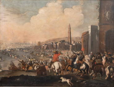
Exceptional large Detailed Panoramic Old Master (17th/18th century) Oil on Canvas Painting. BattleCollective Hudson4.5(60)See Sold PriceMar 01, 2024
Photograph album of over 240 silverprints of Rio & Brazil 1944PBA Galleries4.7(389)See Sold PriceMar 07, 2024