Nova et Accurata Regni Hungariae Tabula, ad Usum SereNova et Accurata Regni Hungariae Tabula, ad Usum Serenissimi Burgundiae Ducis. Grenzkol. Kupferstichkarte n. Guillaume de L' Isle b. Jean Covens & Corneille Mortier, 1741. Plattenmaße ca. 49 x 58,5.See Sold Price
1745 Nova et Accurata Regni Hungariae Tabula, ad UsumBy: I. Covens and C. Mortier par Guillaume de l’IsleDate: 1745 (published) AmsterdamDimensions: 19 x 22.5 inches (48.3 cm x 57.2 cm)Description: This authentic antique hand colored map by I.CovSee Sold Price
Nova et Accurata Regni Hungariae Tabula, ad UsumNova et Accurata Regni Hungariae Tabula, ad Usum Serenissimi Burgundiae Ducis. Kolorierter Kupferstich n. Guillaume de L' Isle b. Jean Covens & Corneille Mortier, 1741. Plattengröße ca. 49 x 58,5. GSee Sold Price
Nova et Accurata Regni Hungariae Tabula, ad UsumNova et Accurata Regni Hungariae Tabula, ad Usum Serenissimi Burgundiae Ducis. Grenzkol. Kupferstichkarte nach Guillaume de L'Isle bei Jean Covens & Corneille Mortier, 1741. Plattenmaße ca. 49 x 58,5See Sold Price
Nova et Accurata Regni Hungariae Tabula, ad UsumNova et Accurata Regni Hungariae Tabula, ad Usum Serenissimi Burgundiae Ducis. Grenzkol. Kupferstichkarte n. Guillaume de L' Isle b. Jean Covens & Corneille Mortier, 1741. Plattenmaße ca. 49 x 58,5.See Sold Price
SoldStriking example of Homann's map of Poland, Lithuania,Regni Poloniae Magnique Ducatus Lithuaniae Nova et exacta tabula ad memtem Starovolcy descripta. Johann Baptist Homann (1664-1724). Copperplate engraving with original hand color. Nuremberg, ca. 1740.See Sold Price
SoldFRAMED ANTIQUE MAP OF LITHUANIA BY HOMANN JOHANN"Regni Poloniae Magnique Ducat Lithuaniae, nova et exacta tabula ad mentem Starovolcii descripta / a Iohanne. Bapt. Homanno", (1720) hand colored copper engraving, on wove paper, in a silver molded frSee Sold Price
SoldHomann map of New Spain, Louisiana, ColoniesTitle: Regni Mexicani seu Novae Hispaniae Ludovicianae, N. Angliae, Carolinae, Virginiae, et Pensylvaniae nec non Insularum Archipelagi Mexicani in America Septentrionali Accurata Tabula ... Author: HSee Sold Price
Obis Terrarum nova et accurata tabulaColorful, vivid and detailed world map, circa 1700 published in Amsterdam by Gerard and Leonard Valk during the Golden Age of Dutch Cartography. Hand-colored engraved map presents both the northern anSee Sold Price
Nova et accurata Hungariae cum adiacentib. regn. etTitle/Content of Map: Nova et accurata Hungariae cum adiacentib. regn. et principatibus tabula Date Printed: 1728 Cartographer: Mattaus Seutter Material/Medium: paperSize: 61cm x 54cm Provenance: auctSee Sold Price
Valk, Gerhard. Orbis Terrarum Nova et Accurata TabulaValk, Gerhard Orbis Terrarum Nova et Accurata Tabula 1700 Copperplate engraving; old coloured Printed area: 50 x 35.5 cm; 19.7 x 14 in An exquisitely decorated double hemisphere world map which also cSee Sold Price
SoldValk map of the World, California an islandTitle: Orbis Terrarum Nova et Accurata Tabula Author: Valk, Gerard & Leonard Description: Copper-engraved double-hemisphere map of the world, hand-colored, surrounded by hand-colored allegorical engraSee Sold Price
Sold4 Maps: Luxemburg, etc. 2 hand colored. Ca. 18th[EUROPE]. 4 Maps. Good - very good condition, defects noted below. All but one is double-page engravings (3 hand-colored). ++ Danckerts. Ducatus Lutzenburgi Nova et Accurata Tabula cum Adjacentibus PrSee Sold Price
SoldGerard (1652-1726) and Leonard Valk (1675-1746)Lot 93 Gerard (1652-1726) and Leonard Valk (1675-1746) ORBIS TERRARUM NOVA ET ACCURATA TABULA Amsterdam, c.1700, hand coloured double hemisphere map of the world, with projections of the poles and elaSee Sold Price
Nova et accurata totius Regni Scotiae...Georg Matthäus Seutter, Nova et accurata totius Regni Scotiae..., engraving (hand colored), ca. 1729, 19.5x 23 19.5x 23See Sold Price
Sold(2pc) MAPS OF FRANCE & HOLLANDIncluding NOVA PROVINCIAE TABULA AD USUM SERENISSUMU BURGUNDIAE DUCIS... LE DUC DE BOURGOGNE by H. Iallot, engraving with early colors [18-3/4 x 24-1/2 in. (sight), 26-1/4 x 32-1/4 in. (overall)], andSee Sold Price
(2pc) MAPS OF FRANCE & HOLLANDIncluding NOVA PROVINCIAE TABULA AD USUM SERENISSUMU BURGUNDIAE DUCIS... LE DUC DE BOURGOGNE by H. Iallot, engraving with early colors [18-3/4 x 24-1/2 in. (sight), 26-1/4 x 32-1/4 in. (overall)], andSee Sold Price
SoldJaillot's Decorative World Map, Nova Orbis Tabula,Alexis-Hubert Jaillot (1632-1712) – renowned French cartographer and publisher Nova Orbis Tabula ad, usum serenissimi Burgundiae Ducis… Colored copper engraving map of the New World, published inSee Sold Price
SoldSchottland (Seutter): Nova ... Scotiae ... delineaSchottland. Nova et accurata totius Regni Scotiae ... Delineatio. Grenz-, landschafts- und flächenkolorierter Kupferstich mit kolorierter figürlicher Kartusche und ebensolchem Meilenmesser. 58 x 50See Sold Price
Guillaume de l’Isle, Map of the Modern World, Paris,Guillaume de l'Isle (1675-1726) – French cartographer in services of King Louis XIV. 'Nova orbis tabula ad Usum Serenißim Burgundiae Ducis - Mappe Monde Dreßé sur les observations de M. de L`AcadSee Sold Price
(2pc) MAPS OF FRANCE & HOLLANDIncluding NOVA PROVINCIAE TABULA AD USUM SERENISSUMU BURGUNDIAE DUCIS... LE DUC DE BOURGOGNE by H. Iallot, engraving with early colors [18-3/4 x 24-1/2 in. (sight), 26-1/4 x 32-1/4 in. (overall)], andSee Sold Price
Sold Nova et accurata Carinthiae Ducatus Tabula geographicNova et accurata Carinthiae Ducatus Tabula geographica... Kol. Kupferstichkarte von Johann Baptist Homann. Nürnberg, um 1716. Plattengröße ca. 58 x 49 cm. Dekorative Karte von Kärnten mit den SalzSee Sold Price
Brazil. SCHENK – BLAEU. Nova et accurata Brasiliae totius tabula.SCHENK, Peter – BLAEU, Johannes. Nova et accurata Brasiliae totius tabula auctore Joanne Blaeu.Amsterdam 1720Acquaforte di 500x600 mm. Coloritura coeva. Bell’esemplare. Nel 1694 Pieter SchSee Sold Price
SoldBrasilien (Blaeu): Nova et accurata Brasiliae tabuBrasilien (Blaeu) - Nova et Accurata Brasiliae totius tabula. Kupferstich mit allegorischer Kartusche, kleiner Windrose und Segelschiffen sowie mit leuchtendem zeitgenöss. Grenz- und Flächenkolorit.See Sold Price
17TH C. WORLD MAP BY NICOLAES VISSCHER (NETHERLANDS, 1618-1709)Thomaston Place Auction Galleries4.4(386)See Sold PriceFeb 24, 2024
WILLEM JANSZOON BLAEU (NETHERLANDS, 1571-1638)Thomaston Place Auction Galleries4.4(386)See Sold PriceFeb 24, 2024
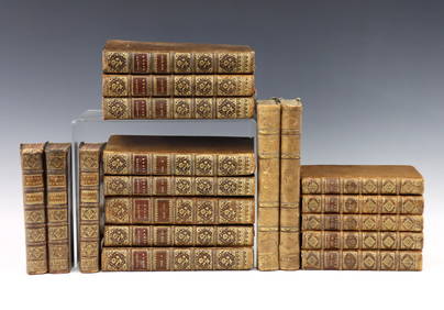
Antique Bounded Book in Wooden Stand - CistercianBodnar's Auction Sales4.6(609)See Sold PriceMar 06, 2024
Willem Blaeu, Etc. 17th C. Antiquarian Maps, 2Auctions at Showplace4.5(726)See Sold PriceMar 17, 2024
De Jode, Rare, pub. 1593 - Map of Italy (Italiae Totius Orbis olim Domatricis Nova ExactissTrillium Antique Prints & Rare Books4.5(30)See Sold PriceFeb 24, 2024
1640s ANTIQUE BLINDSTAMP PIGSKIN FOLIO ANTONINI DIANA Resolutionum MoraliumJasper524.5(9.8k)See Sold PriceFeb 27, 2024
1540 MISSAL ILLUSTRATED FOLIO antique EXTREMELY RARE 16th CENTURYJasper524.5(9.8k)See Sold PriceFeb 27, 2024
1660 Valerius Maximus Cum Selectis Observati ANTIQUE VELLUM BINDINGJasper524.5(9.8k)See Sold PriceFeb 27, 2024
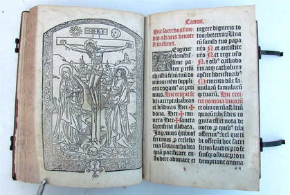
1499 INCUNABULA FOLIO antique Sacred letters of St.Paul interpretation INCUNABLEJasper524.5(9.8k)See Sold PriceFeb 27, 2024
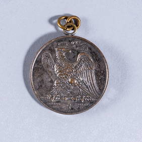
1807 A.D. NAPOLÉON BONAPARTE BRONZE MEDALPridham's Auctions & Appraisals4.7(223)See Sold PriceMar 02, 2024