ATLAS of ANTIENT GEOGRAPHY by SAMUEL BUTLER 1843John McInnis Auctioneers,LLC4.6(504)See Sold PriceFeb 24, 2024
18TH C. ANTIQUE MAP: FRENCH & INDIAN WAR, FRAMEDThomaston Place Auction Galleries4.4(389)See Sold PriceFeb 24, 2024
Rand McNally Railroad Map Cabinet w/ 21 Railroad MapsRail & Road Auctions4.6(165)See Sold PriceMar 08, 2024
Keith Haring - Ink on New York Map, Best Buddies, Inscribed, Signed, and DatedSapphire Auction Gallery4.1(67)See Sold PriceMar 02, 2024
LATE 17TH C. FRENCH MAP OF THE NEW WORLD BY ALEXIS-HUBERT JAILLOT (1632-1712)Thomaston Place Auction Galleries4.4(389)See Sold PriceFeb 24, 2024
Central Railroad of New Jersey Map of Sandy Hook Route-ca. 1903JM Hobby Supply and Railroad Artifact Auctions4.4(126)See Sold PriceFeb 24, 2024
Lot of Six Mixed Atlas Box Cars-HO Scale-New in BoxJM Hobby Supply and Railroad Artifact Auctions4.4(126)See Sold PriceFeb 25, 2024
Rand McNally/Santa Fe Railroad Map of Iowa-1912JM Hobby Supply and Railroad Artifact Auctions4.4(126)See Sold PriceFeb 24, 2024
NICOLAES VISSCHER (NETHERLANDS, 1618-1709) MAP OF THE NEW WORLDThomaston Place Auction Galleries4.4(389)See Sold PriceFeb 24, 2024
17TH C. WORLD MAP BY NICOLAES VISSCHER (NETHERLANDS, 1618-1709)Thomaston Place Auction Galleries4.4(389)See Sold PriceFeb 24, 2024
Lot of Six Mixed Atlas Cabooses-HO Scale-New in BoxJM Hobby Supply and Railroad Artifact Auctions4.4(126)See Sold PriceFeb 25, 2024
Sold(2pc) MAPS OF FRANCE & HOLLANDIncluding NOVA PROVINCIAE TABULA AD USUM SERENISSUMU BURGUNDIAE DUCIS... LE DUC DE BOURGOGNE by H. Iallot, engraving with early colors [18-3/4 x 24-1/2 in. (sight), 26-1/4 x 32-1/4 in. (overall)], andSee Sold Price
(2pc) MAPS OF FRANCE & HOLLANDIncluding NOVA PROVINCIAE TABULA AD USUM SERENISSUMU BURGUNDIAE DUCIS... LE DUC DE BOURGOGNE by H. Iallot, engraving with early colors [18-3/4 x 24-1/2 in. (sight), 26-1/4 x 32-1/4 in. (overall)], andSee Sold Price
(2pc) MAPS OF FRANCE & HOLLANDIncluding NOVA PROVINCIAE TABULA AD USUM SERENISSUMU BURGUNDIAE DUCIS... LE DUC DE BOURGOGNE by H. Iallot, engraving with early colors [18-3/4 x 24-1/2 in. (sight), 26-1/4 x 32-1/4 in. (overall)], andSee Sold Price
Map of France, Holland & Belgium, 1862Map: France, Holland & Belgium, 1862 Original engraving by Johnson and Ward. Divided into two separate maps. The left hand map focuses on France and is color coded according to department, includes inSee Sold Price
SoldFrance, Holland and BelgiumMap: France, Holland and Belgium Date: 1862 Cartographer: Johnson and Browning Material: paper Dimensions: 26.75"wide x 18"high Great color, insets of Corsica, Amsterdam and Brussels. The 1862 ribbonSee Sold Price
SoldBartholomew, John 1922 - 6 Maps. France Belgium HollandLarge Lithograph Maps Published 1922 by The Times, London for "The Times Survey Atlas of the World" Maps by John George Bartholomew of the Edinburgh Geographical Institute. Centre fold as issued. PapeSee Sold Price
1852 Map of France, Holland and BelgiumAuthor: Johnson Title: 1852 Map of France, Holland and Belgium Medium: Ink on Paper Dimensions: 26"X18.5" Map of France, Holland and Belgium . Double folio map engraved by A.J. Johnson dated 1852. PubSee Sold Price
1860 Map of France, Holland and BelgiumAuthor: Johnson Title: 1860 Map of France, Holland and Belgium Medium: Ink on Paper Dimensions: 26.5"X18" Two separate maps of France, Holland and Belgium dated 1860. Engraved by A.J. Johnson. PublishSee Sold Price
1852 Map of France, Holland and BelgiumAuthor: Johnson Title: 1852 Map of France, Holland and Belgium Medium: Ink on Paper Dimensions: 26"X18.5" Map of France, Holland and Belgium . Double folio map engraved by A.J. Johnson dated 1852. PubSee Sold Price
1860 Maps of France, Holland and BelgiumAuthor: Johnson Title: 1860 Maps of France, Holland and Belgium Medium: Ink on Paper Dimensions: 26.5"X18" Description: Two separate maps of France, Holland and Belgium dated 1860. Engraved by A.J. JoSee Sold Price
SoldWWII SILK MAP FRANCE GERMANY BELGIUM HOLLANDWWII SILK MAP FRANCE GERMANY BELGIUM HOLLAND Size: 29'' by 29''See Sold Price
Johnson's France, Holland & Belgium. 2 maps on one sheet 1862 old antiqueTITLE/CONTENT OF MAP: 'Johnson's France // Johnson's Holland and Belgium' DATE PRINTED: 1862 IMAGE SIZE: Approx 42.0 x 64.5cm, 16.5 x 25.25 inches (Large); Please note that this is a folding map. TYPESee Sold Price
Johnson's France, Holland & Belgium. 2 maps on one sheet 1862 old antiqueTITLE/CONTENT OF MAP: 'Johnson's France // Johnson's Holland and Belgium' DATE PRINTED: 1862 IMAGE SIZE: Approx 42.0 x 64.5cm, 16.5 x 25.25 inches (Large); Please note that this is a folding map. TYPESee Sold Price
SoldMalte-Brun: Map of North France Belgium & Holland, 1812Map: 1812 Malte-Brun Map of Northern France, Belgium and Holland -- Partie Septentrionale de l'Empire Francis Cartographer: M Malte-Brun Year / Place: 1812, Paris Dimensions: 8.7 X 11.7 in. Condition:See Sold Price
SoldNotes on G.S.G.S. Maps of France, Belgium and Holland,title and introduction, several coloured maps with accompanying text, original cloth backed printed boards, stained and frayed, folio, 1943; Notes on G.S.G.S. Maps of Germany, Denmark and Central EuroSee Sold Price
Sold(ZEMKE'S WOLF PACK) EMERGENCY/ESCAPE SILK MAP(ZEMKE'S WOLF PACK) EMERGENCY/ESCAPE SILK MAP 1: 1,000,000 scale maps, depicting France, Belgium, and Holland, with a 1:500,000-scale inset of the Pyrenees, on one side, and northern Spain and southerSee Sold Price
Sold(18) 19th Century Johnson's & London News MapsTo include Johnson's hand colored maps of China, Palestine, France, Holland, Belgium, Roman Empire, South America, Turkey & Arabia, New Brunswick & Newfoundland, Australia, Brazil, Agentine, ParaguaySee Sold Price
Johnson's France (and) Johnson's Holland And BelgiumTitle/Content of Map: Johnson's France (and) Johnson's Holland And Belgium Date: 1863 Cartographer: JOHNSON AND WARD Publisher: JOHNSON AND WARD Size: 14Height - 22.5Width Two folio sized maps on doubSee Sold Price
SoldWorld War II Airman's double sided silk map of France,World War II Airman's double sided silk map of France, Belgium and Holland, unframedSee Sold Price
Johnson's France, Holland & Belgium. 2 maps on one sheet. Benelux 1861 oldCAPTION PRINTED BELOW PICTURE: 'Johnson's France // Johnson's Holland and Belgium' DATE PRINTED: 1861 IMAGE SIZE: Approx 42.5 x 65.5cm, 16.75 x 25.75 inches (Large); Please note that this is a foldingSee Sold Price
Soldmap, Holland, Belgium, France, GermanyFramed two-sided map of Holland, Belgium, France and Germany, 20th centurySee Sold Price
SoldLot of 2 WWII Air Force silk escape mapsN-031 Lot of 2 WWII Air force silk "escape" maps: (1) British "FRANCE". Reverse "Germany". 23" x 18 1/2". (2) US color map. Holland - BELGIUM - FRANCE (NORTH EAST) - GERMANY (WEST & CENTRAL). ReverseSee Sold Price
SoldBryce, James 1881 Mixed Lot of European MapsIncl Europe Continent, Britain under Saxons/Romans, Russia, Italy, Spain/Portugal, Swtizerland, Holland/Belgium, and France. Lithograph Maps Published 1881, London for ""The International Atlas and GeSee Sold Price
SoldWWII U.S. ARMY SILK MAPSWWII U.S. ARMY SILK MAPS 2 Holland Belgium France and Germany. Water proof pouch maps only LT. Reese.See Sold Price
(2pc) France BACCARAT Decanter and Crystal VasePremier Auction Galleries4.3(329)See Sold PriceMar 09, 2024
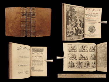
1699 Jean Dumont VOYAGES in France Italy Germany ROME Malta Turkey Ottoman 3vSchilb Antiquarian Rare Books4.8(422)See Sold PriceMar 31, 2024
1937 Holland, Michigan, Tulip Time Map Guide, FramedLakeshore Event Center4.6(105)See Sold PriceMar 02, 2024
D'Entrecasteaux - Australia: Coasts of Van Diemen's Land (New Holland). 9Trillium Antique Prints & Rare Books4.5(30)See Sold PriceFeb 24, 2024
D'Entrecasteaux - Australia: Chart of Van Diemen's Land (New Holland). 3Trillium Antique Prints & Rare Books4.5(30)See Sold PriceFeb 24, 2024
D'Entrecasteaux - Map of Australia (New Holland), New Zealand, and southern Asia and surroundingTrillium Antique Prints & Rare Books4.5(30)See Sold PriceFeb 24, 2024
ANTIQUE AMERICAN PICTURE FROM 1807 DEPICTING THE NAPOLEONIC EMPIRE OR BELGIAN TRAVELER.NY Elizabeth 4.3(85)See Sold PriceMar 03, 2024
Antique Map of France, 1703 by Gillaume Del Isle PrintAntiques Online Auctions4.6(410)See Sold PriceMar 14, 2024
Galliae Regionis Nova Descriptio Hand Colored Map of France on Laid Paper, Ca. 16th Century, H 10" WDuMouchelles4.6(829)See Sold PriceMar 15, 2024