ATLAS of ANTIENT GEOGRAPHY by SAMUEL BUTLER 1843John McInnis Auctioneers,LLC4.5(505)See Sold PriceFeb 24, 2024
18TH C. ANTIQUE MAP: FRENCH & INDIAN WAR, FRAMEDThomaston Place Auction Galleries4.4(394)See Sold PriceFeb 24, 2024
Rand McNally Railroad Map Cabinet w/ 21 Railroad MapsRail & Road Auctions4.6(165)See Sold PriceMar 08, 2024
Keith Haring - Ink on New York Map, Best Buddies, Inscribed, Signed, and DatedSapphire Auction Gallery4.1(67)See Sold PriceMar 02, 2024
LATE 17TH C. FRENCH MAP OF THE NEW WORLD BY ALEXIS-HUBERT JAILLOT (1632-1712)Thomaston Place Auction Galleries4.4(394)See Sold PriceFeb 24, 2024
Central Railroad of New Jersey Map of Sandy Hook Route-ca. 1903JM Hobby Supply and Railroad Artifact Auctions4.4(127)See Sold PriceFeb 24, 2024
Lot of Six Mixed Atlas Box Cars-HO Scale-New in BoxJM Hobby Supply and Railroad Artifact Auctions4.4(127)See Sold PriceFeb 25, 2024
Rand McNally/Santa Fe Railroad Map of Iowa-1912JM Hobby Supply and Railroad Artifact Auctions4.4(127)See Sold PriceFeb 24, 2024
NICOLAES VISSCHER (NETHERLANDS, 1618-1709) MAP OF THE NEW WORLDThomaston Place Auction Galleries4.4(394)See Sold PriceFeb 24, 2024
17TH C. WORLD MAP BY NICOLAES VISSCHER (NETHERLANDS, 1618-1709)Thomaston Place Auction Galleries4.4(394)See Sold PriceFeb 24, 2024
Lot of Six Mixed Atlas Cabooses-HO Scale-New in BoxJM Hobby Supply and Railroad Artifact Auctions4.4(127)See Sold PriceFeb 25, 2024
Sold1817 American Coast Pilot by Blunt Nautical MAPS1817 American Coast Pilot by Blunt Nautical MAPS Navigation Lighthouses Harbors Originally printed in 1796 (Adams), Edmund Blunt’s ‘American Coast Pilot’ was one of the earliest American works oSee Sold Price
SoldAntique 19c. Nautical Maps James Imray Sons LondonAntique 19c. Nautical Maps James Imray Sons London Publisher North Sea China Coast Sudan Strait River Plate. Comes with bone weight. Each map displays toning and foxing, edge wear and tears, box displSee Sold Price
SoldNAUTICAL MAP OF THE ANTILLESA Chart of the Antilles or Caribs Islands with the Virgin Isles. Hand colored. Relief shown pictorially. Depths shown by soundings. Professionally framed, non glare.Measures 21 1/2"x24"x1 1 1/4". PROVSee Sold Price
SoldFour Nautical Maps.Four Nautical Maps. Includes Massachusetts Bay, Lower Guinea (1811), Occidentale Afrique (1738) and a 3-dimensional map of Lake Michigan Largest sight: 14 1/2" x 50 1/2" frame: 16" x 21 3/4"See Sold Price
van Keulen: Antique Nautical Map of Sicily Italy, 1724Large and rare nautical antique chart of Sicily, Italy. 'Nieuwe Afteekening van het Eyland en Koninkryk Sicilia Vertoonende alle desselfs Zee Havenen Anker Plaetsen Riviere Dieptens Klippen Steeden enSee Sold Price
SoldSix 18th and Early 19th Century Nautical Mapsall shrink-wrapped behind mats, titled as follows: Harbour on the Coast of Chili (1770); Port of Permambuco (1816); Chart of New Zealand (1817); Chart of the Intertropical & West Coasts of AustraliaSee Sold Price
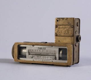
Sold3 Nautical Maps inc. Southern 18611st item: Nautical Map: A New Chart of the Western or Atlantic Ocean, Drawn from the Best Authorities by J. S. Norie, printed London, 1831. Shows the coasts of the United States, Labrador and EskmauxSee Sold Price
SoldPORTULANS ancient nautical maps in the Este library‘Portulans’ are medieval nautical maps, provided with a wealth of geographical coastal names, conceived for being used by seafarers. Due to the fact that they used to be frequently rolled up and cSee Sold Price
SoldTWO FRAMED ENGLISH NAUTICAL MAPScomprising 'Harwich Harbor' and 'Great Circle Sailing Chart of the North Atlantic Ocean' Harwich Harbor: 27 x 52 inches sight; the other, 32 1/4 x 38 1/2 inches sightSee Sold Price
SoldMODERN FRAMED GREAT LAKES NAUTICAL MAPSMODERN FRAMED GREAT LAKES NAUTICAL MAPS, 2, 36" X 48" & 33" X 40":"Great Lakes - St.. Lawrence River", 2009 and "Lake Huron", 2005.See Sold Price
SoldNautical Map / Sea Chart, #224 Oyster & Huntington BaysUnited States East Coast, New York, Oyster & Huntington Bays, South Shore of Long Island Sound, 3rd edition feb 1/43; revised 7/21/58, note heavier bond paper and or better preserved than most; FoldedSee Sold Price
SoldNautical Map / Sea Chart, #1212 Eastern Long IslandDescription: Nautical Map / Sea Chart, United States East Coast, Connecticut - New York, Long Island Sound, Eastern Part, 12th edition feb 10 / 69 ; all measurements are approximate; Folded; ShippingSee Sold Price
SoldNautical Map / Sea Chart, #1211 MarthaDescription: Nautical Map / Sea Chart, United States East Coast, Rhode Island - Connecticut - New York, Block Island Sound and Approaces9th edition, dec 23/63 stamped CORRECTED ONLY FOR AIDS & HAZARDSSee Sold Price
SoldNautical Map / Sea Chart, #362 Block Island Sound andDescription: Nautical Map / Sea Chart, United States East Coast, New York, Long Island, Block Island Sound and Gardiner's Bay, 6th edition, Feb 10/69; Shipping: $20; different rate to California, AlasSee Sold Price
Sold60 nautical maps: US Coast Survey, [ca. 1858].[Coast Survey]. 60 maps from a United States Coast Survey annual report, most maps dated 1857. [Wash: GPO, c.1858]. 4to. Includes: ++ 3 copies of New England's coast (Map 1). ++ Seacoast of Part of AlSee Sold Price
45 Nautical Maps, 1850-1900Collection of 45 Nautical maps from 1850-1900, to include: 2 Japan, 3 South America, 1 North America, 5 Phillipines, 6 Australia, 3 France, 2 Africa, 15 China and Provinces, 8 Pacific Island and ChinaSee Sold Price
Sold1872 book w/ 20 nautical maps: Central America.[Nautical Maps]. Robert W. Shufeldt. Reports Of Explorations And Surveys, To Ascertain the Practicability of a Ship-Canal between the Atlantic and Pacific Oceans, by Way of the Isthmus of Tehuantepec.See Sold Price
Sold6 nautical maps6 nautical maps, 1930s mounted to linen US map, Asiatic, South America and Russian mapsSee Sold Price
SoldLot of Nautical Maps and sea chartsLot of Nautical maps and sea charts 6 pieces, also included 1960's restrike view of NYSee Sold Price
West Indies, Eastern Cuba 1881 British Admiralty Nautical MapScarce Original 1877 British Admiralty Nautical Chart: West Indies Cuba The Eastern Portion From a Chart Published At The Hydrographical Office Madrid, 1837. Corrected From Surveys and Observations bySee Sold Price
SoldNautical MapsA collection of (6) large nautical maps. One from 1910, others are 1940s. Includes map of the North Atlantic and several from the Pacific Northwest.See Sold Price
SoldJOSEPH ROUX (1725-1793). "NAUTICAL MAPS OF THESeven etchings. The first, indentified by the artist and dated 1771. Various maps forming the "Map of The Gulf of Lyons (Marseilles, 1771) and the"Specific Map of The Coasts of Provence" (Marseilles,See Sold Price
West Indies, Western Cuba 1879 British Admiralty Nautical MapScarce Original 1879 British Admiralty Nautical Chart: West Indies Cuba the Western Portion From a Chart Published at the Hydrographical Office Madrid 1837. Corrected from Surveys and Observations bySee Sold Price
1885 CIVIL WAR 1ed Famous Memoirs US Grant Sheridan Sherman 6v RARE LOT MapsSchilb Antiquarian Rare Books4.8(431)See Sold PriceMar 10, 2024
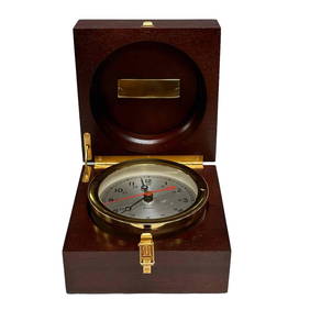
Chelsea Nautical Chronometer Boxed Presentation ClockPremier Auction Galleries4.3(338)See Sold PriceMar 09, 2024
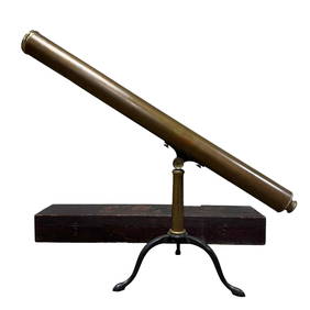
19th Century Brass Nautical Telescope and TripodPremier Auction Galleries4.3(338)See Sold PriceMar 09, 2024
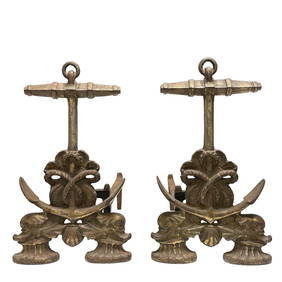
Fine Pair of Nautical Anchor and Dolphin AndironsPremier Auction Galleries4.3(338)See Sold PriceMar 09, 2024
Large lot of assorted prints. 18th-20th century. To include: North American and other maps, CivilTremont Auctions4.5(298)See Sold PriceFeb 25, 2024
Rand McNally Railroad Map Cabinet w/ 21 Railroad MapsRail & Road Auctions4.6(165)See Sold PriceMar 08, 2024
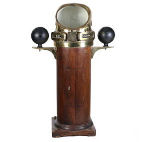
Japanese Brass Nautical Salvage Ship Binnacle LampHill Auction Gallery 4.7(1k)See Sold PriceFeb 28, 2024
Nautical Marine Salvage Industrial Ships BinnacleHill Auction Gallery 4.7(1k)See Sold PriceFeb 28, 2024
Willem Blaeu, Etc. 17th C. Antiquarian Maps, 2Auctions at Showplace4.6(744)See Sold PriceMar 17, 2024
Putnam - First Map of the State of Ohio by Rufus PutnamTrillium Antique Prints & Rare Books4.5(33)See Sold PriceFeb 24, 2024
De Jode, Rare, pub. 1593 - Map of Africa (Africae Vera Forma, et Situs)Trillium Antique Prints & Rare Books4.5(33)See Sold PriceFeb 24, 2024
Southern Africa Cape of Good Hope-Madagascar ADMIRALTY sea chart 1935 (1955) mapJasper524.5(9.9k)See Sold PriceFeb 28, 2024
Gulf of Guinea. Ghana Togo Benin Nigeria. ADMIRALTY sea chart 1928 (1954) mapJasper524.5(9.9k)See Sold PriceFeb 28, 2024
South Namibia coast. Walvis Bay-Orange River ADMIRALTY sea chart 1881 (1954) mapJasper524.5(9.9k)See Sold PriceFeb 28, 2024
Vintage Framed Cat Island Nautical Map PrintRapid Estate Liquidators and Auction Gallery4.5(1.1k)See Sold PriceFeb 25, 2024
Vintage Italian hand made display of nautical pullies and knots of wood and rope. Laid in woodenJoshua Kodner4.2(395)See Sold PriceMar 09, 2024
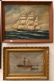
Nautical Oil on Canvas PaintingM.J. Stasak Jr. Auction and Appraisal Service4.8(2.1k)See Sold PriceMar 10, 2024


![60 nautical maps: US Coast Survey, [ca. 1858]. (1 of 3)](https://p1.liveauctioneers.com/179/14187/4432324_1_x.jpg?height=282&quality=70&version=1194393062)