SoldMap CaseMap case, painted white with hand painted nautical views, glass top, five drawers, 18" h x 45 1/2" w x 35" d. Provenance: MA estate.See Sold Price
SoldArnie Wegner Wooden Ship Model, Lake MichiganArnie Wegner (American, 1912-1999). A wooden ship's model in glass case, the pine wood boat rigged with two masts and five sails with corded rope, dangling anchor, and displayed against a map inscribeSee Sold Price
SoldDufour/Dyonnet: Australia, Oceania with Island InsetsA superbly detailed nautical chart of the Pacific Ocean showing all of Australia, Indonesia, and Japan as well as most of North America and the west coast of South. Includes five insets: southeasternSee Sold Price
SoldLot of Vintage Scuba, Skin Diver & Spearfishing MemorabCollection of items related to different diving activities. Items include a USS kittiwake dive map, SS Yongala Dive To The Past book, five diving patches, spearfishing medal, two vintage diving decalsSee Sold Price
Sold1817 American Coast Pilot by Blunt Nautical MAPS1817 American Coast Pilot by Blunt Nautical MAPS Navigation Lighthouses Harbors Originally printed in 1796 (Adams), Edmund Blunt’s ‘American Coast Pilot’ was one of the earliest American works oSee Sold Price
SoldAntique Maps: Collection of Five Map Depicting VariousAll unframed. Largest: 14" wd x 8.5" ht.See Sold Price
SoldFive Maps and Cityscape PrintsIncluding a rolled map of the Florida coastline. Largest Sight Size: 17"h x 40-1/2"wSee Sold Price
SoldFive Maps by Abraham Ortelius (1527-1598), Three "LaFive Maps by Abraham Ortelius (1527-1598), Three "La Florida Aue Tore Hieron Chiaues; Two Guastecan Reg," 1583, H.- 8 3/4 in., W.- 11 1/2 in., and H.- 17 1/2 in., W.- 11 in. (5 Pcs.)See Sold Price
SoldAntique 19c. Nautical Maps James Imray Sons LondonAntique 19c. Nautical Maps James Imray Sons London Publisher North Sea China Coast Sudan Strait River Plate. Comes with bone weight. Each map displays toning and foxing, edge wear and tears, box displSee Sold Price
SoldNAUTICAL MAP OF THE ANTILLESA Chart of the Antilles or Caribs Islands with the Virgin Isles. Hand colored. Relief shown pictorially. Depths shown by soundings. Professionally framed, non glare.Measures 21 1/2"x24"x1 1 1/4". PROVSee Sold Price
SoldFour Nautical Maps.Four Nautical Maps. Includes Massachusetts Bay, Lower Guinea (1811), Occidentale Afrique (1738) and a 3-dimensional map of Lake Michigan Largest sight: 14 1/2" x 50 1/2" frame: 16" x 21 3/4"See Sold Price
SoldRoyal Doulton, group of seven (7) items: five nauticalRoyal Doulton, group of seven (7) items: five nautical figures and two mug, England, polychrome glazed ceramic, signed, (2) Tall Story (HN 2248), The Boatman (HN 2417), Sailor's Holiday (HN 2442), TheSee Sold Price
van Keulen: Antique Nautical Map of Sicily Italy, 1724Large and rare nautical antique chart of Sicily, Italy. 'Nieuwe Afteekening van het Eyland en Koninkryk Sicilia Vertoonende alle desselfs Zee Havenen Anker Plaetsen Riviere Dieptens Klippen Steeden enSee Sold Price
SoldSix 18th and Early 19th Century Nautical Mapsall shrink-wrapped behind mats, titled as follows: Harbour on the Coast of Chili (1770); Port of Permambuco (1816); Chart of New Zealand (1817); Chart of the Intertropical & West Coasts of AustraliaSee Sold Price
SoldFive Nautical Engravings by E.W. Cooke and George CookeLargest: Sight: 7.5" wd. x 9.5" ht., Framed: 14.5" wd. x 16" ht. Titles: "Prussian Snow", "Barque", "The Thames near Limhouse, called the Lower Pool", "Sailing Barges", "Greenwich Hospital".See Sold Price
Sold3 Nautical Maps inc. Southern 18611st item: Nautical Map: A New Chart of the Western or Atlantic Ocean, Drawn from the Best Authorities by J. S. Norie, printed London, 1831. Shows the coasts of the United States, Labrador and EskmauxSee Sold Price
SoldFIVE MAPS: VIEWS OF DANZIG AND POLAND German andFIVE MAPS: VIEWS OF DANZIG AND POLAND German and England, i.a. Johann Baptist Homann, James Wyld, 18th and 19th century Engraving and lithograph, coloured, on different papers. Visible sitze 50 x 59 cSee Sold Price
SoldPORTULANS ancient nautical maps in the Este library‘Portulans’ are medieval nautical maps, provided with a wealth of geographical coastal names, conceived for being used by seafarers. Due to the fact that they used to be frequently rolled up and cSee Sold Price
SoldTWO FRAMED ENGLISH NAUTICAL MAPScomprising 'Harwich Harbor' and 'Great Circle Sailing Chart of the North Atlantic Ocean' Harwich Harbor: 27 x 52 inches sight; the other, 32 1/4 x 38 1/2 inches sightSee Sold Price
SoldMODERN FRAMED GREAT LAKES NAUTICAL MAPSMODERN FRAMED GREAT LAKES NAUTICAL MAPS, 2, 36" X 48" & 33" X 40":"Great Lakes - St.. Lawrence River", 2009 and "Lake Huron", 2005.See Sold Price
Sold1847 Five Maps Europe1847 FIVE Maps Spain, France, Germany, Belgium, and Italy. Some borders handcolored. By Vuillemin, Paris. 9.5” x 12”. Very Good to Fine.See Sold Price
SoldFive maps of U.S.Heading: (United States) Author: Title: Five maps of the United States Place Published: Various places Publisher: Date Published: Various dates Description: Five engraved oSee Sold Price
Fort Wayne and Pennsylvania RR 1880 Public TimetableJM Hobby Supply and Railroad Artifact Auctions4.4(127)See Sold PriceFeb 24, 2024
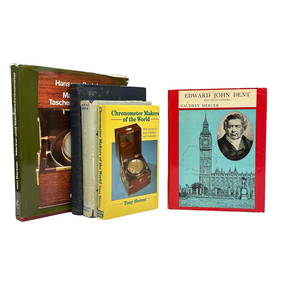
The Life and Letters of Edward John Dent and Chronometer BooksPremier Auction Galleries4.3(338)See Sold PriceMar 09, 2024
1853 Colton's Railroad & Township Map of Massachusetts, Rhode Island, and ConnecticutRail & Road Auctions4.6(165)See Sold PriceMar 07, 2024
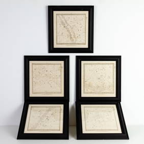
Set of Five Astronomical Zodiac Maps of the Stars by Baldwin & Gradock 1830Passion For Antiques4(24)See Sold PriceFeb 25, 2024
Georgian Five Tier Brass Nautical Telescope LondonPassion For Antiques4(24)See Sold PriceFeb 24, 2024
ALIEN3 (1992) - Hand-drawn Bait and Chase Five Page Storyboard and MapPropstore4.3(7)See Sold PriceMar 13, 2024
Southern Africa Cape of Good Hope-Madagascar ADMIRALTY sea chart 1935 (1955) mapJasper524.5(9.9k)See Sold PriceFeb 28, 2024
Gulf of Guinea. Ghana Togo Benin Nigeria. ADMIRALTY sea chart 1928 (1954) mapJasper524.5(9.9k)See Sold PriceFeb 28, 2024
South Namibia coast. Walvis Bay-Orange River ADMIRALTY sea chart 1881 (1954) mapJasper524.5(9.9k)See Sold PriceFeb 28, 2024
Vintage Framed Cat Island Nautical Map PrintRapid Estate Liquidators and Auction Gallery4.5(1.1k)See Sold PriceFeb 25, 2024
1675: ANTIQUE ILLUSTRATED JULIUS CAESAR MAPS OF ROMAN HISTORYNY Elizabeth 4.1(88)See Sold PriceMar 03, 2024
Framed Five Millionth Nautical Mile Queen Elizabeth 2 ShipRapid Estate Liquidators and Auction Gallery4.5(1.1k)See Sold PriceMar 01, 2024
Vintage Italian hand made display of nautical pullies and knots of wood and rope. Laid in woodenJoshua Kodner4.2(395)See Sold PriceMar 09, 2024
Five (5) Antique Blown Glass Nautical BuoysPremier Auction Galleries4.3(338)See Sold PriceMar 29, 2024