Ms. map of Yada Ecchu Province Japan c.1850Title: Large manuscript map of Yada village in the Fushiki region of Ecchu Province in Japan Author: ** Description: Ink & watercolor on paper. 148x250 cm. (58¼x98½").Rare 19th century manuscript maSee Sold Price
SoldMs. map of Yada Ecchu Province Japan c.1850Heading: (Japan - Yada villlage) Author: Title: Large manuscript map of Yada village in the Fushiki region of Ecchu Province in Japan Place Published: Japan Publisher: Date Published: c.1850See Sold Price
SoldMs. Map of Feather River c.1850Title: Map of Feather River, from the upper bounds of Yuba City to Hancut Creek, the upper boundary of Cap. Sutter's land Author: ** Description: Manuscript map, pen-&-ink on paper, backed with linen.See Sold Price
SoldPictorial map of Japan 1886Heading: (Japan) Author: Sagano, Hikotaro Title: Dai Nihon zenzu (The picture of the Great Whole Map of Japan; Provinces in the Japanese Empire, including Korea) Place Published: Japan Publisher:SaganSee Sold Price
Rare 19th century atlas of JapanHeading: (Japan - Atlas) Author: Ao Tokei Motonobu Title: Kokugun Zenzu. (Ino Tadaka Atlas of Japan: Complete maps of Provinces & Counties [of Japan]) Place Published: Nagoya Publisher:Eirakuya ToshirSee Sold Price
Rare 19th century atlas of JapanHeading: (Japan - Atlas) Author: Ao Tokei Motonobu Title: Kokugun Zenzu. (Ino Tadaka Atlas of Japan: Complete maps of Provinces & Counties [of Japan]) Place Published: Nagoya Publisher:Eirakuya ToshirSee Sold Price
SoldMS. map of sea routes to Nagasaki c.1841Heading: (Asian) Author: Inoue Gen (Inouehara?) Title: “Nagasaki kairiku no zu” - [Map of sea travel from Nagasaki] Place Published: [Nagasaki, Japan?] Publisher: Date Published: Tempo12 [184See Sold Price
SoldA MASSIVE MUSEUM QUALITY JAPANESE PORCELAIN MAP OFTempo reign (1830-1843), commonly referred to as Imari. Decorated with an underglaze blue map of Japan in low relief in the cavetto showing two panels of calligraphy and the provinces of Japan. The unSee Sold Price
[Atlas, Japan] Ichikawa, 1837A RARE ATLAS OF JAPAN, THAT WAS VERY INFLUENTIAL IN THE DEVELOPMENT OF JAPANESE CARTOGRAPHY Ichikawa Tokei (1765-1838). Kokugun zenzu[Complete Map of Provinces and Districts]. 2 volumes (28.2 x 19.7cmSee Sold Price
SoldRare and large map of Japan 1871Heading: (Japan) Author: Suzuki Kien after Nagakubo, Sekisui Title: Zotai dainihon kokugun yochi rotei zenzu/ cho Sekisui; Suzuki kien Zotei (Enlarged and revised map of provinces and Itineraries of GSee Sold Price
Rare and large map of Japan 1871Heading: (Japan) Author: Suzuki Kien after Nagakubo, Sekisui Title: Zotai dainihon kokugun yochi rotei zenzu/ cho Sekisui; Suzuki kien Zotei (Enlarged and revised map of provinces and Itineraries of GSee Sold Price
SoldAntique Hand Colored Map of JapanA striking map of the island of Japan. Shows provinces, islands, towns, mountains, rivers, islands etc.Sight size: 8.25 x 12 inches.See Sold Price
Engraved Ivory Manju NetsukeEngraved Ivory Manju Netsuke 19th Century Titled Dai Nippon Koku Shoshin dzu, provinces of Japan correctly drawn, engraved with a map of Japan on both sides, incised lines stained black. Diameter 1 1See Sold Price
Martini (Martinus) [Novus Atlas Sinensis][Martini (Martinus)] [Novus Atlas Sinensis], 16 double-page engraved maps by J.Blaeu (of 17), comprising general maps of China and Japan, and 14 maps of Chinese Provinces, all with outline hanSee Sold Price
Nishikawa (Jubu) - A large map of Omi province,featuring Lake Biwa, Japan's largest lake, its islands and fishing boats, extensive text panels around, woodcut map with hand-colouring, on four sheets, joined, 825 x 1370mm., a few wormholes, foldingSee Sold Price
Nine Provinces in Kyushu, JapanHeading: (Japan - Kyushu) Author: Noriyuki, artist (after Toshimaya, Bunjiemon) Title: Kyushu kyu ka koku no ezu (Picture Map of the Nine Provinces in Kyushu) Place Published: Nagasaki Publisher:ToyosSee Sold Price
East Coast of South America Brazil Middle ProvincesTitle: East Coast of South America Brazil Middle Provinces Prublication Date: c1850 Cartographer: BARTHOLOMEW, J./G. H. SWANSTON Publisher: A. Fullarton & Co. Size: 18.5Height - 12Width Additional InfSee Sold Price
SoldAtlas of Japan 1834Heading: (Japan - Atlas) Author: Yoshifura, Yamazaki Title: Dainihon kochi Benran. (Atlas of color maps of the Japanese provinces and a world map, simplified) Place Published: Japan Publisher: DaSee Sold Price
Atlas of Japan 1834Heading: (Japan - Atlas) Author: Yoshifura, Yamazaki Title: Dainihon kochi Benran. (Atlas of color maps of the Japanese provinces and a world map, simplified) Place Published: Japan Publisher: DaSee Sold Price
Japan.- Woodblock Map Centred around TokyoJapanese Regional Woodblock Map Centred around Tokyoa late Edo woodblock map of the old provinces of Hitacji, Shimoksuke, Kozuke, Kai, Shinano, Totomi and the area surrounding Tokyo, this citSee Sold Price
Korea.- Yojido atlasKorea.- Yojido atlas, 13 double-page maps, including 'doughnut' shanhaijing world map, China, the Korean peninsula, the Ryukyu Islands, Japan, and 8 provinces, with several text leaves, woodblSee Sold Price
SoldMotonobu (Aô Tôkei) - Kokugun Zenzu,2 vol atlas, complete with 75 double-page maps, including a general map of Japan, the remainder covering the 68 provinces, colour-printed woodblock maps, occasional minor finger soiling at sheet edgesSee Sold Price
SoldRussian Empire Period National war map Including theRussian Empire Period National war map Including the Empire of Japan in the northeast province of China, such as in marine and sea battles 28張蘇俄帝國時期See Sold Price
SoldTwo Japanese Printed Maps(lot of 2) Unframed Japanese printed maps, the first of Edo (old designation for Tokyo), original one printed in 1811, the second of old Japan with all the provinces, lords and famous temples, the oriSee Sold Price
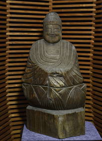
17thC Enku Buddha Masterpiece, monk, poet, and famous Japanese pre-modern sculptorThe Buddha Gallery4.4(29)See Sold PriceMar 13, 2024
MAP - Dufour, A. H. ( Malte / Brun ) :MAP - ESPAGNE PARTIE SUD DIVISEE EN PROVINCES ANCIENNES ( MAPLuis Porretta Fine Arts4.3(10)See Sold PriceMar 02, 2024
Joseph Martin Kronheim Pair Early Color Glamor Prints c1850Luis Porretta Fine Arts4.3(10)See Sold PriceMar 02, 2024
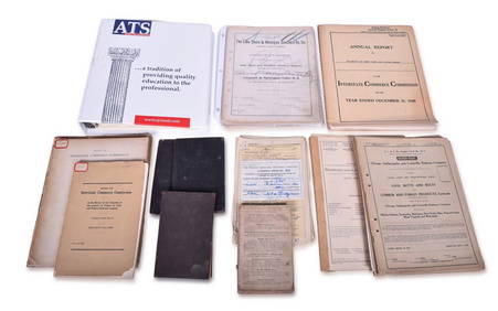
1963 J.F.K. for US PRESIDENT RE-ELECTION MATERIALJohn McInnis Auctioneers,LLC4.6(502)See Sold PriceFeb 25, 2024
Group of Lake Shore & Michigan Southern Railroad PaperRail & Road Auctions4.6(165)See Sold PriceMar 07, 2024
Antique German Kampen Town Color Copper EtchingHill Auction Gallery 4.7(1k)See Sold PriceFeb 28, 2024
Duval - Pair: Map of India & Map of MaldivesTrillium Antique Prints & Rare Books4.5(30)See Sold PriceFeb 24, 2024
Utagawa Toyokuni III Woodblock - Settsu ProvinceFloating World Auctions4.7(233)See Sold PriceMar 01, 2024
San Xavier Del Bac Mission, Edward S. Curtis photogravurePBA Galleries4.7(381)See Sold PriceMar 07, 2024
Cooke, George 1801 Antique Map. United States of AmericaAlbion Auctions4.6(336)See Sold PriceMar 01, 2024
Perry, Matthew C. 1856 Large Map. Shah Bay, Lew Chew I. JapanAlbion Auctions4.6(336)See Sold PriceMar 01, 2024
ANTIQUE ILLUSTRATED HANDBOOK OF GEOGRAPHY AND TRAVEL IN ASIA, VOLUME 2, 1896NY Elizabeth 4.3(84)See Sold PriceMar 03, 2024
Henri Plon - Set of 10 Prints - Ethnography - Pekin - Japan - Anthropologic LithographyProverde Auctions4.3(3)See Sold PriceFeb 28, 2024
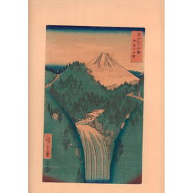
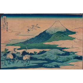
Hiroshige (Japanese) Woodblock Print, Mountains of IzuLion and Unicorn4.7(1.8k)See Sold PriceMar 14, 2024


![[Atlas, Japan] Ichikawa, 1837 (1 of 7)](https://p1.liveauctioneers.com/2198/96026/49300167_1_x.jpg?height=282&quality=70&version=1480075738)


![Martini (Martinus) [Novus Atlas Sinensis] (1 of 1)](https://p1.liveauctioneers.com/410/3027/1300133_1_x.jpg?height=282&quality=70)