SoldMs. Map of Feather River c.1850Title: Map of Feather River, from the upper bounds of Yuba City to Hancut Creek, the upper boundary of Cap. Sutter's land Author: ** Description: Manuscript map, pen-&-ink on paper, backed with linen.See Sold Price
SoldRare map of the Northern Mines 1851Heading: Author: Milleson, M. and R. Adams Title: A Complete Map of the Feather & Yuba Rivers With Towns, Ranches, diggings, Roads, distances. Compiled from the recent survey of M. Milleson & R. AdamSee Sold Price
Ms. map of Yada Ecchu Province Japan c.1850Title: Large manuscript map of Yada village in the Fushiki region of Ecchu Province in Japan Author: ** Description: Ink & watercolor on paper. 148x250 cm. (58¼x98½").Rare 19th century manuscript maSee Sold Price
SoldMs. map of Yada Ecchu Province Japan c.1850Heading: (Japan - Yada villlage) Author: Title: Large manuscript map of Yada village in the Fushiki region of Ecchu Province in Japan Place Published: Japan Publisher: Date Published: c.1850See Sold Price
SoldSacramento River Valley with mapHeading: (California) Author: Title: Sacramento, San Joaquin, and Feather Rivers, California. Letter from The Secretary of War, transmitting, with a letter from the Chief of Engineers, Report of ExamSee Sold Price
Sold1895 Sutter Basin California MapThis is an original 1895 map of the Sutter Basin in California. The map shows various features including the Sacramento River, Feather River, Yuba City, Marysville, and many more. The map is in good cSee Sold Price
SoldMap of Oroville Gold Dredging District (51502)Sketch map of major consolidations of Oroville gold dredging district 1910-1913. Map has Marysville in the north then south to Natomas consolidated on the Feather River. 23.25" x 18". Folded conditionSee Sold Price
SoldAuto Club of Southern California Road Map (122298)From Mono Lake to Lake Tahoe and the Feather River Region with resorts, camp sites, fishing streams, lakes, mountain peaks and trails. Pamphlet, 9 x 33" when unfolded.Date: 1920Country if not USA: StaSee Sold Price
SoldRare road map from Mono to Tahoe 1932Heading: (California) Author: Title: Automobile Road Map from Mono Lake to Lake Tahoe and Feather River Region: Showing resorts, camp sites, fishing streams, lakes, mountain peaks, and trails Place PSee Sold Price
SoldRare road map from Mono to Tahoe 1930Heading: (California) Author: Title: Automobile Road Map from Mono Lake to Lake Tahoe and Feather River Region: Showing resorts, camp sites, fishing streams, lakes, mountain peaks, and trails Place PSee Sold Price
Sacramento River Valley with mapHeading: (California) Author: Title: Sacramento, San Joaquin, and Feather Rivers, California. Letter from The Secretary of War, transmitting, with a letter from the Chief of Engineers, Report of ExamSee Sold Price
Sacramento River Valley with mapHeading: (California) Author: Title: Sacramento, San Joaquin, and Feather Rivers, California. Letter from The Secretary of War, transmitting, with a letter from the Chief of Engineers, Report of ExamSee Sold Price
SoldSacramento River Survey. 1911, 31 maps.Heading: (California - Sacramento River)) Author: United States Army Corps of Engineers Title: Examination and Survey of Sacramento River: from Sacramento to Red Bluff; and Survey from Feather River tSee Sold Price
SoldTwo Vintage California Zephyr Travel AdvertisementTwo Vintage California Zephyr Travel Advertisement Poster Brochures, ca. 1950s, In folder form depicting the California Zephyr in Feather River Canyon with daily schedules and system map. Sponsored bySee Sold Price
Two Vintage California Zephyr Travel AdvertisementTwo Vintage California Zephyr Travel Advertisement Poster Brochures, ca. 1950s, In folder form depicting the California Zephyr in Feather River Canyon with daily schedules and system map. Sponsored bySee Sold Price
SoldFRÉMONT.Geographical Memoir upon Upper Californi“The first widely circulated map to announce the location of the discovery of gold deposits along the American and Feather rivers”—Ehrenberg 67. FRÉMONT, John Charles. GeograpSee Sold Price
SDUK: Antique Map, MO MS IL IN KY AL Mississippi RiverTitle/Content of Map: 'NORTH AMERICA, SHEET X., Parts of Missouri, Illinois, Kentucky, Tennessee, Alabama, Missouri and Arkansas' Arkansas Tennessee. MO MS IL IN KY AL. Mississippi River. Date PrintedSee Sold Price
Plan De Oswego 1727. (from Paris Doc. Viii)Title: Plan De Oswego 1727. (from Paris Doc. Viii) Publication Date: c1850 Cartographer: Chaussegros de Lery Publisher: Gavit & Duthie Dimensions: 10.1 X 14.4 Additional Information: Map of the riverSee Sold Price
Diagram Map of the State of Missouri, 1849Map: Diagram of the State of MissouriMaker: G.l.O., Clark, M. Lewis Publisher: G.L.O, Washington DC 1849Size: Folio – 17.50 H x 21.75 W Inches Map shows survey grid, MS & MO rivers and disputed nortSee Sold Price
1776 Map of the Original Thirteen ColoniesPublication Date: 1884 Title: 1776 Map of the Original Thirteen Colonies Cartographer: MITCHELL, S.A. Publisher: MITCHELL, S.A. Map showing west to the MS River. Details ancient French boundary, IndiaSee Sold Price
Sold[Hamilton (John A] The Ms. in a Red Box[Hamilton (John Arthur)] The Ms. in a Red Box, first edition, folding map, spotted, inscribed by the author, original cloth, spine soiled, 1903 § Dunston (G.) The Rivers of Axholme, portrait,See Sold Price
SoldNorth Carolina. With insert of gold mining region andTitle: North Carolina. With insert of gold mining region and Neuse river area. 1850 by Thomas Date/Period: c1850. Materials: Hand colored steel engraved Size: 16 1/2 x 13 1/2 inches. c1850 by Thomas,See Sold Price
North Carolina. With insert of gold mining region andTitle: North Carolina. With insert of gold mining region and Neuse river area. 1850 by Thomas Date/Period: c1850. Materials: Hand colored steel engraved Size: 16 1/2 x 13 1/2 inches. c1850 by Thomas,See Sold Price
SoldUnited StatesTitle/Content of Map: United States Date Printed: 1805 Cartographer: Arrowsmith & Lewis Material/Medium: Arrowsmith & Lewis Size: 8X9.8 Map detailing east of the Mississippi River. Shows MS TerritorySee Sold Price
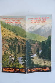
Western Pacific RR Feather River Canyon/Salt Lake City/National Parks Brochure-ca. 1925JM Hobby Supply and Railroad Artifact Auctions4.4(126)See Sold PriceFeb 24, 2024
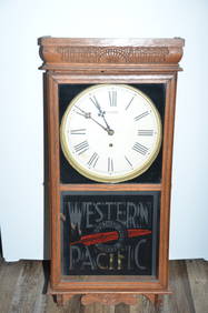
Western Pacific RR Station ClockJM Hobby Supply and Railroad Artifact Auctions4.4(126)See Sold PriceFeb 24, 2024
Numismatic Books - Fowles & Legg - John Aubrey's Monumenta Britannica, Part I & IITimeLine Auctions Ltd.4.5(183)See Sold PriceMar 09, 2024
Numismatic Books - Fowles & Legg - John Aubrey's Monumenta Britannica, Part III and IndexTimeLine Auctions Ltd.4.5(183)See Sold PriceMar 09, 2024
WEST AFRICA Explorers' routes Senegal Ashanti. Mountains of Kong. SDUK 1857 mapJasper524.5(9.8k)See Sold PriceFeb 28, 2024
Northern & Southern Africa. Maghreb. Orange River Sovereignty. HALL 1854 mapJasper524.5(9.8k)See Sold PriceFeb 28, 2024
La Barbarie de la Nigritie et de la Guinée'. West Africa. DE L’ISLE 1745 mapJasper524.5(9.8k)See Sold PriceFeb 28, 2024
COLONIES FRANÇAISES en AFRIQUE. Africa Sénégal Madagascar. LEVASSEUR c1850 mapJasper524.5(9.8k)See Sold PriceFeb 28, 2024
Northern & Southern Africa. Maghreb. Orange River Sovereignty. HALL 1856 mapJasper524.5(9.8k)See Sold PriceFeb 28, 2024
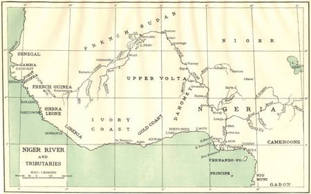
AFRICA. Niger River and Tributaries 1936 old vintage map plan chartJasper524.5(9.8k)See Sold PriceFeb 28, 2024
Rivières de Sanaga & Gambra'. Senegal Gambia rivers. Guinea. BELLIN 1746 mapJasper524.5(9.8k)See Sold PriceFeb 28, 2024
A LARGE ERRATA BOOK INDIAN MAPS AND STUDIES including the provinces of Bengal, Cossimbuzar Island, THannam's Auctioneers Ltd4.3(386)See Sold PriceFeb 27, 2024
John Senex Map of Louisiana & Mississippi RiverWillow Auction House4.5(283)See Sold PriceMar 14, 2024


![[Hamilton (John A] The Ms. in a Red Box (1 of 0)](https://p1.liveauctioneers.com/dist/images/placeholder.jpg?height=282&quality=70)