ATLAS of ANTIENT GEOGRAPHY by SAMUEL BUTLER 1843John McInnis Auctioneers,LLC4.6(502)See Sold PriceFeb 24, 2024
18TH C. ANTIQUE MAP: FRENCH & INDIAN WAR, FRAMEDThomaston Place Auction Galleries4.4(386)See Sold PriceFeb 24, 2024
Rand McNally Railroad Map Cabinet w/ 21 Railroad MapsRail & Road Auctions4.6(165)See Sold PriceMar 08, 2024
Keith Haring - Ink on New York Map, Best Buddies, Inscribed, Signed, and DatedSapphire Auction Gallery4(67)See Sold PriceMar 02, 2024
LATE 17TH C. FRENCH MAP OF THE NEW WORLD BY ALEXIS-HUBERT JAILLOT (1632-1712)Thomaston Place Auction Galleries4.4(386)See Sold PriceFeb 24, 2024
Central Railroad of New Jersey Map of Sandy Hook Route-ca. 1903JM Hobby Supply and Railroad Artifact Auctions4.4(126)See Sold PriceFeb 24, 2024
Lot of Six Mixed Atlas Box Cars-HO Scale-New in BoxJM Hobby Supply and Railroad Artifact Auctions4.4(126)See Sold PriceFeb 25, 2024
Rand McNally/Santa Fe Railroad Map of Iowa-1912JM Hobby Supply and Railroad Artifact Auctions4.4(126)See Sold PriceFeb 24, 2024
NICOLAES VISSCHER (NETHERLANDS, 1618-1709) MAP OF THE NEW WORLDThomaston Place Auction Galleries4.4(386)See Sold PriceFeb 24, 2024
17TH C. WORLD MAP BY NICOLAES VISSCHER (NETHERLANDS, 1618-1709)Thomaston Place Auction Galleries4.4(386)See Sold PriceFeb 24, 2024
Lot of Six Mixed Atlas Cabooses-HO Scale-New in BoxJM Hobby Supply and Railroad Artifact Auctions4.4(126)See Sold PriceFeb 25, 2024
Monin, V 1833 Maps (3) Alger, Guyane, Sengal. Africa3 French Colony Maps. One of French Guiana, the others North and West Africa. Steel Engraved Maps Published 1833, Paris for "Petit Atlas National des départements de la France et de ses colonies" bySee Sold Price
Monin, V 1833 Maps (3) Alger, Guyane, Sengal. Africa3 French Colony Maps. One of French Guiana, the others North and West Africa. Steel Engraved Maps Published 1833, Paris for "Petit Atlas National des départements de la France et de ses colonies" bySee Sold Price
SoldMonin, V 1833 Lot of 3 French Department MapsIncl Vienne, Haute Vienne and Yonne. Steel Engraved Maps Published 1833, Paris for "Petit Atlas National des départements de la France et de ses colonies" by V. Monin. Paper Size: 12.5 x 10 inch (32See Sold Price
SoldMonin, V. 1833 Lot of 5 French Colony Maps. Reunion etcPlus Guadeloupe, Guyana, Alger, and Senegambie ou Senegal. Steel Engraved Maps Published 1833, Paris for "Petit Atlas National des départements de la France et de ses colonies" by V. Monin. Paper SizSee Sold Price
Monin, V 1833 Maps (2) Guadeloupe & Reunion"La Guadeloupe" and "Ile Bourbon" Steel Engraved Maps Published 1833, Paris for "Petit Atlas National des départements de la France et de ses colonies" by V. Monin. Paper Size: 12.5 x 10 inch (32 x 2See Sold Price
Monin, V 1833 Maps (2) Guadeloupe & Reunion"La Guadeloupe" and "Ile Bourbon" Steel Engraved Maps Published 1833, Paris for "Petit Atlas National des départements de la France et de ses colonies" by V. Monin. Paper Size: 12.5 x 10 inch (32 x 2See Sold Price
SoldMonin, V 1833 Lot of 5 French Department MapsVendee, Tarn et Garonne, Vaucluse, Vosges, and Var. Steel Engraved Maps Published 1833, Paris for "Petit Atlas National des départements de la France et de ses colonies" by V. Monin. Paper Size: 12.5See Sold Price
Sold1833 ATLAS MAPS Cartography Navigation Voyages1833 ATLAS MAPS Cartography Navigation Voyages Illustrated French Petit Monin Charles V. Monin was a 19th-century French cartographer who was one of the first Europeans to print maps under the printinSee Sold Price
Map of Africa. 1835.Print of hand colored steel engraving titled Afrique“.Author C. V. Monin.Engraved by unknown.From the Atlas Universel de Geography“ by C. V. Monin. Parsi. 1835.Africa is the world's second-largestSee Sold Price
Map of Africa. 1835.Print of hand colored steel engraving titled „Afrique“.Author C. V. Monin.Engraved by unknown.From the „Atlas Universel de Geography“ by C. V. Monin. Parsi. 1835.Africa is the world's second-lSee Sold Price
1839 Africa by MoninTitle/Content: 1839 Africa by Monin Date: 1839 Medium: Hand colored, engraved Dimensions: 17 1/2" x 12 1/2" Description: Map of Africa with interior unknown. 1839. By V. Monin. Paris. Hand-colored, enSee Sold Price
Map of Egypt. Africa. 1835.Print of hand colored steel engraving titled „Egypte“.Author C. V. Monin.Engraved by unknown.From the „Atlas Universel de Geography“ by C. V. Monin. Parsi. 1835.Egypt officially the Arab RepubSee Sold Price
Map of Egypt. Africa. 1835.Print of hand colored steel engraving titled Egypte“.Author C. V. Monin.Engraved by unknown.From the Atlas Universel de Geography“ by C. V. Monin. Parsi. 1835.Egypt officially the Arab Republic ofSee Sold Price
Map of North Africa. 1835.Print of hand colored steel engraving titled „Afrique septentrionale“.Author C. V. Monin.Engraved by unknown.From the „Atlas Universel de Geography“ by C. V. Monin. Parsi. 1835.North Africa orSee Sold Price
Map of South Africa. 1835.Print of hand colored steel engraving titled „Afrique Maridionale“.Author C. V. Monin.Engraved by unknown.From the „Atlas Universel de Geography“ by C. V. Monin. Parsi. 1835.South Africa, offiSee Sold Price
Map of North Africa. 1835.Print of hand colored steel engraving titled Afrique septentrionale“.Author C. V. Monin.Engraved by unknown.From the Atlas Universel de Geography“ by C. V. Monin. Parsi. 1835.North Africa or NorthSee Sold Price
Levasseur (V.) Africa; Asia; S. AmericaLevasseur (Victor) Afrique; Am‚rique M‚ridionale; Asie,3 continents, each map surrounded by decorative montages of landscapes, animals and plants, native, allegorical and historical figures, eSee Sold Price
SDUK North Africa or Barbary V. Tripoli and Egypt.“North Africa or Barbary V. Tripoli and Egypt.” London: SDUK, 1837. 12 1/2 x 15 3/8. Engraving. Original outline hand-coloring. Very good condition. Please note that this lot has a confidential reSee Sold Price
Sold1835 EXQUISITE French ATLAS Cartography MAPS Navigation1835 EXQUISITE French ATLAS Cartography MAPS Navigation Voyages Illustrated Monin Charles V. Monin was a 19th-century French cartographer who was one of the first Europeans to print maps under the priSee Sold Price
1835 ATLAS MAPS Cartography Navigation Voyages1835 ATLAS MAPS Cartography Navigation Voyages Illustrated Monin French Petit Charles V. Monin was a 19th-century French cartographer who was one of the first Europeans to print maps under the printinSee Sold Price
Sold1835 ATLAS MAPS Cartography Navigation Voyages Illustra1835 ATLAS MAPS Cartography Navigation Voyages Illustrated Monin French Petit Charles V. Monin was a 19th-century French cartographer who was one of the first Europeans to print maps under the printinSee Sold Price
Sold1833 Nubia & Abyssinia EGYPT Ethiopia Africa Missions1833 Nubia & Abyssinia EGYPT Ethiopia Africa Missions Geography MAP Bishop Michael Russell was a 19th-century historian who was well-versed in a variety of subjects, including Biblical and Holy Land hSee Sold Price
SoldLOT (3) EARLY POCKET BOOK MAPS C.1830'sLOT (3) EARLY POCKET BOOK MAPS INCL. H/C STATE OF NEW YORK BY HUMPHREY PHELPS,1833, 16" X 21", STATE OF NEW JERSEY BY J. LOW, C. 1830, 10 1/2" X 7 1/2", STATE OF PENNSYLVANIA BY A. FINLEY, C. 1830, 9"See Sold Price
SoldOrtelius's maps of the continents (5)ORTELIUS, Abraham (1527-1598). Typvs Orbis Terrarvm. 1598; Evropa. 1598; Asia. 1598; Africa. 1598; America five Novvis Orbis. 1598. All measure 4 3/8 x 5 3/4 inches.See Sold Price
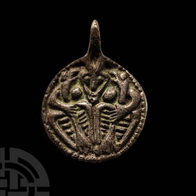
Viking Age Scandinavian Silver Pendant with Odin and his Ravens Huginn and MuninnTimeLine Auctions Ltd.4.5(183)See Sold PriceMar 05, 2024
Archaeological Books - Hilprecht - The Excavations in Assyria and BabyloniaTimeLine Auctions Ltd.4.5(183)See Sold PriceMar 06, 2024
Adriaen van Ostade. 6 etchings. 1) Farmer and Wife in Loving Embrace at Window. X state. 2) "EmptyTremont Auctions4.6(293)See Sold PriceFeb 25, 2024
[LITHOGRAPHY]. [CHILDREN]. Group of 43 Trade Cards or Label...Potter & Potter Auctions4.6(539)See Sold PriceMar 07, 2024
[SOUTH AFRICA]. A group of 3 Anti-Apartheid posters, comprising:Freeman's | Hindman4.4(1.6k)See Sold PriceFeb 27, 2024
Carey, pub. 1796 - Map of KentuckyTrillium Antique Prints & Rare Books4.5(30)See Sold PriceFeb 24, 2024
Carey, pub. 1796 - Map of the Tennassee State formerly part of North Carolina (Tennessee)Trillium Antique Prints & Rare Books4.5(30)See Sold PriceFeb 24, 2024
De Jode, Rare, pub. 1593 - Map of Africa (Africae Vera Forma, et Situs)Trillium Antique Prints & Rare Books4.5(30)See Sold PriceFeb 24, 2024
1736 LARGE MAP OF SILESIA POLAND OPPAVIENSIS antique 25 by 34 3/4"Jasper524.5(9.8k)See Sold PriceFeb 27, 2024
W.G. & Co. Limoges Porcelain Vase With Handles, Roses + BaseLion and Unicorn4.7(1.8k)See Sold PriceMar 03, 2024
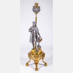
Victorian Christopher Columbus Kerosene Floor LampGray's Auctioneers4.5(186)See Sold PriceMar 06, 2024


![[LITHOGRAPHY]. [CHILDREN]. Group of 43 Trade Cards or Label... (1 of 1)](https://p1.liveauctioneers.com/928/318880/171361045_1_x.jpg?height=282&quality=70&version=1707501302)
![[SOUTH AFRICA]. A group of 3 Anti-Apartheid posters, comprising: (1 of 3)](https://p1.liveauctioneers.com/197/319238/171467923_1_x.jpg?height=282&quality=70&version=1707520367)


![Vintage Airplane Desk Model [Air France] (1 of 7)](https://p1.liveauctioneers.com/5755/320282/172113951_1_x.jpg?height=282&quality=70&version=1708463029)