MOLL, Herman (ca 1654-1732). A New and Correct MapMOLL, Herman (ca 1654-1732). A New and Correct Map of the Whole World. [London]: Printed for John Bowles, [1719]. Large engraved map on four sheets, joined, hand-colored in outline, large allegoricalSee Sold Price
MOLL, Herman (ca 1654-1732). A New and Correct MaMOLL, Herman (ca 1654-1732). A New and Correct Map of the Whole World. [London]: Printed for John Bowles, [1719]. Large engraved map on four sheets, joined, hand-colored in outline, large allegoricalSee Sold Price
MOLL, Herman (ca 1654-1732). A New and Correct MapMOLL, Herman (ca 1654-1732). A New and Correct Map of the Whole World. [London]: Printed for John Bowles, [1719]. Large engraved map on four sheets, joined, hand-colored in outline, large allegoricalSee Sold Price
Sold* MOLL, Herman (1654?-1732). The World Described; or a* MOLL, Herman (1654?-1732). The World Described; or a new and correct sett of maps. [from letterpress contents leaf]. [London: J. & T. Bowles, ca 1740-1745.] Folio (620 x 525 mm). Title-page and contSee Sold Price
SoldMoll NEW AND CORRECT MAP OF THE WORLD C1730 CopperDetails: MOLL, Herman (1654-1732). A New and Correct Map of the World, Laid Down According to the Newest Discoveries, and From the Most Exact Observations. London: H. Moll, D. Midwinter, T. Bowles, PSee Sold Price
SoldFRAMED HERMAN MOLL "NEW AND CORRECT MAP OF THEMOLL, HERMAN (1654-1732). "A New and Correct Map of the Whole World, Shewing ye Situation of Its Principal Parts...by H. Moll, 1719." London: H. Moll, T. & J. Bowles, P. Overton & J. King, [dated 1719See Sold Price
SoldHerman Moll Map Virginia and Maryland 1741Herman Moll (ca. 1654-1732), "A New Map of Virginia and Maryland," London, 1741. Hand colored engraved map of the Chesapeake Bay region, showing what is now Virginia, Maryland, Delaware, and parts ofSee Sold Price
SoldHerman Moll 1654-1732), "A New And Correct Map of theHerman Moll 1654-1732), "A New And Correct Map of the World," 1710, hand colored, H. - 22 in., W. - 38 in.See Sold Price
SoldHerman Moll (1654-1732) - A New and correct map of theHerman Moll (1654-1732) A New and Correct map of the Whole World, engraving 1719, on joined sheets with old folds, some hand-colouring, 71 x 120cm (visible)See Sold Price
SoldMoll - A New and Correct Map of the World, 1709Herman Moll (1654?-1732), A New and Correct Map of the World, Laid Down According to the Newest Discoveries, and from the Most Exact Observations, London, 1709, black and white engraving with perSee Sold Price
SoldMap, Herman MollHerman Moll (British, 1654-1732), "A New and Correct Map of the World," engraving on glass, overall (with frame): 26.5"h x 42.5"wSee Sold Price
SoldMoll - Correct Map of the Whole World, 1719Herman Moll (1654?-1732), cartographer and publisher A New & Correct Map of the Whole World Shewing y.e Situation of its Principal Parts. Viz the Oceans, Kingdoms, Rivers, Capes, Ports, Mountains, WooSee Sold Price
SoldHerman Moll (1654-1732), hand colored engraving mapHerman Moll (1654-1732), hand colored engraving map "A New and Correct Map of the WHOLE WORLD, Showing Y. e situation of its principal parts viz the oceans, Kingdoms, rivers, capes, ports, mountainsSee Sold Price
SoldGrp: 3 Maps of EuropeGroup of three maps of Europe. Includes one hand colored map of the Netherlands by Herman Moll (1654-1732), "A New Map of the United Provinces of Netherlands &c." London: Herman Moll, ca. 1701; one DuSee Sold Price
Moll Map of South AmericaMoll, Herman (1654-1732). This Map of South America... Engraved map with original hand color in full on two sheets joined. London c. 1719. From The World described; or a New and Correct Sett of Maps..See Sold Price
MOLL, Herman (1654?-1732). A New and Exact Map ofMOLL, Herman (1654?-1732). A New and Exact Map of France. London, [ca 1730]. Engraved map of France, image 604 x 968 mm (sheet 628 x 995 mm) with hand-coloring. Allegorical cartouche depicting the artSee Sold Price
SoldLarge George II Map of Northern Italy by MollMoll, Herman (1654-1732). New Map of the Upper Part of Italy Containing... Engraved map. Thomas Bowles & John Bowles, c.1721. 24" x 40" sheet. "...ye Principality Piermont ye Dutchies of Savoy, Milan,See Sold Price
SoldEarly French Colonies North America HERMAN MOLL C1732Details: MOLL, Herman (1654-1732). A New Map of ye North Parts of America claimed by France under ye Names of Louisiana, Mississipi, Canada & New France, with the Adjoyning Territories of England & SSee Sold Price
SoldHerman Moll Map of Africa ca. 1720Herman Moll (ca. 1654-1732). Map of Africa, London, ca. 1720. With an elaborate dedication cartouche reading "To the right honourable Charles, Earl of Peterborow and Monmouth, etc this map of Africa aSee Sold Price
SoldGrp: Maps of AsiaGroup of eighteen maps of Asia, including two maps of Sumatra; one map of Java; one Herman Moll (ca. 1654-1732) map of the Eurasian steppes; one map of China, Korea, and Japan; one map of Sulawesi (CeSee Sold Price
MOLL, Herman (ca 1654-1732). A New and Correct Map[London]: Printed for John Bowles, [1719]. Large engraved map on four sheets, joined, hand-colored in outline, large allegorical title cartouche in upper left corner after Louis Cheron, additional smaSee Sold Price
SoldHerman Moll (1654-1732), "A New Map of Newfoundland,Herman Moll (1654-1732), "A New Map of Newfoundland, New Scotland..fishing banks," c. 1725, H. - 9 in., W. - 13 1/2 in.See Sold Price
SoldMoll Map of Independent Tartary China ca. 1717Herman Moll (ca. 1654-1732), "A Map of Independent Tartary Containing the Territories of Usbeck, Gasgar, Tibet, Lassa," London, ca. 1711-1717. This early hand colored engraving map depicts the regionSee Sold Price
SoldGrp: 5 Maps of Germany Europe and the MediterraneGroup of five 18th century maps. This group includes a hand colored map of Germany by Herman Moll (ca. 1654-1732); one map of the Turkish empire by Tobias Conrad Lotter (1717-1777); one map of the BriSee Sold Price
1892 Adams and Bowles New Road Map of the State of New YorkJM Hobby Supply and Railroad Artifact Auctions4.4(126)See Sold PriceFeb 24, 2024
Central Railroad of New Jersey Map of Sandy Hook Route-ca. 1903JM Hobby Supply and Railroad Artifact Auctions4.4(126)See Sold PriceFeb 24, 2024
Crams Township and Railroad Map of New York-1890JM Hobby Supply and Railroad Artifact Auctions4.4(126)See Sold PriceFeb 24, 2024
18TH C. ENGLISH PEWTER PLATES & PLATTERS BY ROBERT NICHOLSONThomaston Place Auction Galleries4.4(386)See Sold PriceFeb 24, 2024
LARGE LATE 17TH C. DUTCH CHART OF CANADA, GREAT LAKES, NEW FRANCE, LABRADOR, HUDSON BAY, BY PIERREThomaston Place Auction Galleries4.4(386)See Sold PriceFeb 24, 2024
EARLY 18TH C. DUTCH CHART OF PACIFIC OCEAN BY FREDERIK DE WIT (1629-1706) WITH CALIFORNIA AS ANThomaston Place Auction Galleries4.4(386)See Sold PriceFeb 24, 2024
HOUDINI (Erik Weisz, 1874 – 1926). Signed Portrait of Harry...Potter & Potter Auctions4.6(538)See Sold PriceFeb 24, 2024
Vintage County Map Of NY State Plate EngravingThe Benefit Shop Foundation Inc.4.3(2.9k)See Sold PriceFeb 28, 2024
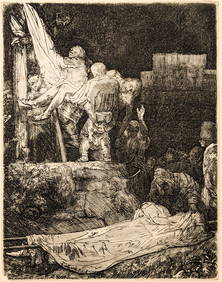
Rembrandt van Rijn. The Descent from the Cross by Torchlight (1654). New Hollstein 286, III/IV OnTremont Auctions4.6(292)See Sold PriceFeb 25, 2024
Portfolio of 15 County Maps by Robert Morden (English 1650-1703)Nadeau's Auction Gallery4.7(398)See Sold PriceFeb 24, 2024
Keith Haring - Ink on New York Map, Best Buddies, Inscribed, Signed, and DatedSapphire Auction Gallery3.9(67)See Sold PriceMar 02, 2024
[ARCTIC]. BOWEN, Emanuel. A New & Accurate Map of the North...Potter & Potter Auctions4.6(538)See Sold PriceMar 07, 2024
[GREETING CARDS]. An Outstanding Victorian Christmas and Ne...Potter & Potter Auctions4.6(538)See Sold PriceMar 07, 2024
[MAP]. [ALBRIZZI, Giambatista, 1698-1777]. Carta Geografica...Potter & Potter Auctions4.6(538)See Sold PriceMar 07, 2024
[BASEBALL CARTE DE VISITE]. Carte de Visite Photograph of a...Potter & Potter Auctions4.6(538)See Sold PriceMar 07, 2024
[BASEBALL]. RUTH, George Herman “Babe” (1895-1948). Origina...Potter & Potter Auctions4.6(538)See Sold PriceMar 07, 2024
Keith Haring Artwork Signed on a Shell Oil New York Road Map 18 in. x 24 in.Donny Malone Auctions4.4(1.7k)See Sold PriceMar 04, 2024
New and Correct Map of North America With the West India Islands,Jasper524.5(9.7k)See Sold PriceFeb 27, 2024
Herman Moll A New Map of Ye North Parts of AmericaWillow Auction House4.5(280)See Sold PriceMar 14, 2024


![[ARCTIC]. BOWEN, Emanuel. A New & Accurate Map of the North... (1 of 1)](https://p1.liveauctioneers.com/928/318880/171360917_1_x.jpg?height=282&quality=70&version=1707501302)
![[GREETING CARDS]. An Outstanding Victorian Christmas and Ne... (1 of 5)](https://p1.liveauctioneers.com/928/318880/171360983_1_x.jpg?height=282&quality=70&version=1707501302)
![[MAP]. [ALBRIZZI, Giambatista, 1698-1777]. Carta Geografica... (1 of 1)](https://p1.liveauctioneers.com/928/318880/171361280_1_x.jpg?height=282&quality=70&version=1707501302)
![[BASEBALL CARTE DE VISITE]. Carte de Visite Photograph of a... (1 of 2)](https://p1.liveauctioneers.com/928/318880/171361405_1_x.jpg?height=282&quality=70&version=1707501302)
![[BASEBALL]. RUTH, George Herman “Babe” (1895-1948). Origina... (1 of 2)](https://p1.liveauctioneers.com/928/318880/171361431_1_x.jpg?height=282&quality=70&version=1707501302)


