ATLAS of ANTIENT GEOGRAPHY by SAMUEL BUTLER 1843John McInnis Auctioneers,LLC4.5(505)See Sold PriceFeb 24, 2024
18TH C. ANTIQUE MAP: FRENCH & INDIAN WAR, FRAMEDThomaston Place Auction Galleries4.4(393)See Sold PriceFeb 24, 2024
Rand McNally Railroad Map Cabinet w/ 21 Railroad MapsRail & Road Auctions4.6(165)See Sold PriceMar 08, 2024
Keith Haring - Ink on New York Map, Best Buddies, Inscribed, Signed, and DatedSapphire Auction Gallery4(67)See Sold PriceMar 02, 2024
LATE 17TH C. FRENCH MAP OF THE NEW WORLD BY ALEXIS-HUBERT JAILLOT (1632-1712)Thomaston Place Auction Galleries4.4(393)See Sold PriceFeb 24, 2024
Central Railroad of New Jersey Map of Sandy Hook Route-ca. 1903JM Hobby Supply and Railroad Artifact Auctions4.4(127)See Sold PriceFeb 24, 2024
Lot of Six Mixed Atlas Box Cars-HO Scale-New in BoxJM Hobby Supply and Railroad Artifact Auctions4.4(127)See Sold PriceFeb 25, 2024
Rand McNally/Santa Fe Railroad Map of Iowa-1912JM Hobby Supply and Railroad Artifact Auctions4.4(127)See Sold PriceFeb 24, 2024
NICOLAES VISSCHER (NETHERLANDS, 1618-1709) MAP OF THE NEW WORLDThomaston Place Auction Galleries4.4(393)See Sold PriceFeb 24, 2024
17TH C. WORLD MAP BY NICOLAES VISSCHER (NETHERLANDS, 1618-1709)Thomaston Place Auction Galleries4.4(393)See Sold PriceFeb 24, 2024
Lot of Six Mixed Atlas Cabooses-HO Scale-New in BoxJM Hobby Supply and Railroad Artifact Auctions4.4(127)See Sold PriceFeb 25, 2024
SoldHerman Moll 1654-1732), "A New And Correct Map of theHerman Moll 1654-1732), "A New And Correct Map of the World," 1710, hand colored, H. - 22 in., W. - 38 in.See Sold Price
SoldHerman Moll (1654-1732) - A New and correct map of theHerman Moll (1654-1732) A New and Correct map of the Whole World, engraving 1719, on joined sheets with old folds, some hand-colouring, 71 x 120cm (visible)See Sold Price
SoldMoll - A New and Correct Map of the World, 1709Herman Moll (1654?-1732), A New and Correct Map of the World, Laid Down According to the Newest Discoveries, and from the Most Exact Observations, London, 1709, black and white engraving with perSee Sold Price
SoldMap, Herman MollHerman Moll (British, 1654-1732), "A New and Correct Map of the World," engraving on glass, overall (with frame): 26.5"h x 42.5"wSee Sold Price
SoldMoll NEW AND CORRECT MAP OF THE WORLD C1730 CopperDetails: MOLL, Herman (1654-1732). A New and Correct Map of the World, Laid Down According to the Newest Discoveries, and From the Most Exact Observations. London: H. Moll, D. Midwinter, T. Bowles, PSee Sold Price
SoldMoll - Correct Map of the Whole World, 1719Herman Moll (1654?-1732), cartographer and publisher A New & Correct Map of the Whole World Shewing y.e Situation of its Principal Parts. Viz the Oceans, Kingdoms, Rivers, Capes, Ports, Mountains, WooSee Sold Price
SoldFRAMED HERMAN MOLL "NEW AND CORRECT MAP OF THEMOLL, HERMAN (1654-1732). "A New and Correct Map of the Whole World, Shewing ye Situation of Its Principal Parts...by H. Moll, 1719." London: H. Moll, T. & J. Bowles, P. Overton & J. King, [dated 1719See Sold Price
MOLL, Herman (ca 1654-1732). A New and Correct MapMOLL, Herman (ca 1654-1732). A New and Correct Map of the Whole World. [London]: Printed for John Bowles, [1719]. Large engraved map on four sheets, joined, hand-colored in outline, large allegoricalSee Sold Price
MOLL, Herman (ca 1654-1732). A New and Correct MaMOLL, Herman (ca 1654-1732). A New and Correct Map of the Whole World. [London]: Printed for John Bowles, [1719]. Large engraved map on four sheets, joined, hand-colored in outline, large allegoricalSee Sold Price
MOLL, Herman (ca 1654-1732). A New and Correct MapMOLL, Herman (ca 1654-1732). A New and Correct Map of the Whole World. [London]: Printed for John Bowles, [1719]. Large engraved map on four sheets, joined, hand-colored in outline, large allegoricalSee Sold Price
SoldHerman Moll (1654-1732), hand colored engraving mapHerman Moll (1654-1732), hand colored engraving map "A New and Correct Map of the WHOLE WORLD, Showing Y. e situation of its principal parts viz the oceans, Kingdoms, rivers, capes, ports, mountainsSee Sold Price
Sold* MOLL, Herman (1654?-1732). The World Described; or a* MOLL, Herman (1654?-1732). The World Described; or a new and correct sett of maps. [from letterpress contents leaf]. [London: J. & T. Bowles, ca 1740-1745.] Folio (620 x 525 mm). Title-page and contSee Sold Price
Moll Map of South AmericaMoll, Herman (1654-1732). This Map of South America... Engraved map with original hand color in full on two sheets joined. London c. 1719. From The World described; or a New and Correct Sett of Maps..See Sold Price
SoldHerman Moll (1654-1732), "A New Map of Newfoundland,Herman Moll (1654-1732), "A New Map of Newfoundland, New Scotland..fishing banks," c. 1725, H. - 9 in., W. - 13 1/2 in.See Sold Price
SoldGrp: 3 Maps of EuropeGroup of three maps of Europe. Includes one hand colored map of the Netherlands by Herman Moll (1654-1732), "A New Map of the United Provinces of Netherlands &c." London: Herman Moll, ca. 1701; one DuSee Sold Price
SoldHerman Moll Map Virginia and Maryland 1741Herman Moll (ca. 1654-1732), "A New Map of Virginia and Maryland," London, 1741. Hand colored engraved map of the Chesapeake Bay region, showing what is now Virginia, Maryland, Delaware, and parts ofSee Sold Price
SoldEarly Map of North AmericaHerman Moll British (1654-1732)A NEW MAP OF THE NORTH PARTS OF AMERICA CLAIMED BY FRANCE UNDRE YE NAMES OF LOUISIANA, MISSISSIPPI, CANADA, AND NEW FRANCE WITH YE ADJOYNING TERRITORIES OF ENGLAND AND SSee Sold Price
SoldLarge George II Map of Northern Italy by MollMoll, Herman (1654-1732). New Map of the Upper Part of Italy Containing... Engraved map. Thomas Bowles & John Bowles, c.1721. 24" x 40" sheet. "...ye Principality Piermont ye Dutchies of Savoy, Milan,See Sold Price
SoldEarly French Colonies North America HERMAN MOLL C1732Details: MOLL, Herman (1654-1732). A New Map of ye North Parts of America claimed by France under ye Names of Louisiana, Mississipi, Canada & New France, with the Adjoyning Territories of England & SSee Sold Price
SoldHerman Moll - Map of North American, 1715Herman Moll (c.1654-1732), "A New and Exact Map of the Dominions of the King of Great Britain... Containing Newfoundland, New Scotland, New England, New York, New Jersey, Pensilvania, Maryland, VirginSee Sold Price
SoldHERMAN MOLL ENGRAVING, NEW MAP OF GREAT BRITAINHERMAN MOLL (DUTCH 1654-1732), HAND COLORED ENGRAVING, " A NEW MAP OF GREAT BRITAIN" 40" X 24" SIGHT:"A New Map of Great Britain, According to the Newest and Most Exact Observations By Herman Moll GeoSee Sold Price
SoldMoll NEW AND EXACT MAP OF FRANCE C1720 Engraved MapDetails: MOLL, Herman. (1654-1732). A New and Exact Map of France Dividid into all its Provinces and Acquisitions, according to the Newest Observations, and that accurate Survey made by the King's CoSee Sold Price
MOLL, Herman (1654?-1732). A New and Exact Map ofMOLL, Herman (1654?-1732). A New and Exact Map of France. London, [ca 1730]. Engraved map of France, image 604 x 968 mm (sheet 628 x 995 mm) with hand-coloring. Allegorical cartouche depicting the artSee Sold Price
Moll Map of American ColoniesMOLL, Herman (c.1654-1732). A New and Exact Map of the Dominions of the King of Great Britain on ye Continent of North America...Engraved Map with original hand color in part. Sold By H. Moll over agaSee Sold Price
1892 Adams and Bowles New Road Map of the State of New YorkJM Hobby Supply and Railroad Artifact Auctions4.4(127)See Sold PriceFeb 24, 2024
Central Railroad of New Jersey Map of Sandy Hook Route-ca. 1903JM Hobby Supply and Railroad Artifact Auctions4.4(127)See Sold PriceFeb 24, 2024
Crams Township and Railroad Map of New York-1890JM Hobby Supply and Railroad Artifact Auctions4.4(127)See Sold PriceFeb 24, 2024
Vintage County Map Of NY State Plate EngravingThe Benefit Shop Foundation Inc.4.3(2.9k)See Sold PriceFeb 28, 2024
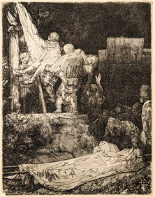
Rembrandt van Rijn. The Descent from the Cross by Torchlight (1654). New Hollstein 286, III/IV OnTremont Auctions4.5(297)See Sold PriceFeb 25, 2024
Portfolio of 15 County Maps by Robert Morden (English 1650-1703)Nadeau's Auction Gallery4.7(409)See Sold PriceFeb 24, 2024
Keith Haring - Ink on New York Map, Best Buddies, Inscribed, Signed, and DatedSapphire Auction Gallery4(67)See Sold PriceMar 02, 2024
1849 THE NEW-ENGLAND MERCANTILE UNIONNorth American Artifact Auctions4.7(198)See Sold PriceApr 20, 2024
[ARCTIC]. BOWEN, Emanuel. A New & Accurate Map of the North...Potter & Potter Auctions4.6(545)See Sold PriceMar 07, 2024
Keith Haring Artwork Signed on a Shell Oil New York Road Map 18 in. x 24 in.Donny Malone Auctions4.4(1.8k)See Sold PriceMar 04, 2024
1750 Bowen Map of Bermuda and St. Kitts -- A New & Accurate Map of Bermudas or Sommer's Islands...Jasper524.5(9.9k)See Sold PriceFeb 27, 2024
New and Correct Map of North America With the West India Islands,Jasper524.5(9.9k)See Sold PriceFeb 27, 2024
Herman Moll A New Map of Ye North Parts of AmericaWillow Auction House4.5(289)See Sold PriceMar 14, 2024


![[ARCTIC]. BOWEN, Emanuel. A New & Accurate Map of the North... (1 of 1)](https://p1.liveauctioneers.com/928/318880/171360917_1_x.jpg?height=282&quality=70&version=1707501302)


