ATLAS of ANTIENT GEOGRAPHY by SAMUEL BUTLER 1843John McInnis Auctioneers,LLC4.6(504)See Sold PriceFeb 24, 2024
18TH C. ANTIQUE MAP: FRENCH & INDIAN WAR, FRAMEDThomaston Place Auction Galleries4.4(389)See Sold PriceFeb 24, 2024
Rand McNally Railroad Map Cabinet w/ 21 Railroad MapsRail & Road Auctions4.6(165)See Sold PriceMar 08, 2024
Keith Haring - Ink on New York Map, Best Buddies, Inscribed, Signed, and DatedSapphire Auction Gallery4.1(67)See Sold PriceMar 02, 2024
LATE 17TH C. FRENCH MAP OF THE NEW WORLD BY ALEXIS-HUBERT JAILLOT (1632-1712)Thomaston Place Auction Galleries4.4(389)See Sold PriceFeb 24, 2024
Central Railroad of New Jersey Map of Sandy Hook Route-ca. 1903JM Hobby Supply and Railroad Artifact Auctions4.4(126)See Sold PriceFeb 24, 2024
Lot of Six Mixed Atlas Box Cars-HO Scale-New in BoxJM Hobby Supply and Railroad Artifact Auctions4.4(126)See Sold PriceFeb 25, 2024
Rand McNally/Santa Fe Railroad Map of Iowa-1912JM Hobby Supply and Railroad Artifact Auctions4.4(126)See Sold PriceFeb 24, 2024
NICOLAES VISSCHER (NETHERLANDS, 1618-1709) MAP OF THE NEW WORLDThomaston Place Auction Galleries4.4(389)See Sold PriceFeb 24, 2024
17TH C. WORLD MAP BY NICOLAES VISSCHER (NETHERLANDS, 1618-1709)Thomaston Place Auction Galleries4.4(389)See Sold PriceFeb 24, 2024
Lot of Six Mixed Atlas Cabooses-HO Scale-New in BoxJM Hobby Supply and Railroad Artifact Auctions4.4(126)See Sold PriceFeb 25, 2024
Sold[Maps] Berthelot, Côtes de Terre Ferme...François Berthelot, Nouvelle Carte de Partie des Côtes de Terre Ferme et Isles Situées sur l'Ocean. 1700 ca. Incisione in rame. mm 545x780. Titolo e dati editoriali entro cartiglio figurato inSee Sold Price
Soldde l'Isle: Antique Map of Northern South America, 1730Map: Carte de la Terre Ferme, du Perou, du Bresil, et du Pays des Amazones Cartographer: de l'Isle / Buache Place & Date: Paris / 1730/1782 Size: 22 3/8" x 19 1/2" Condition: wash color; overall age-tSee Sold Price
de l'Isle / Buache: Antique Map of South America, 1730Map: Carte de la Terre Ferme, du Perou, du Bresil, et du Pays des Amazones Cartographer: de l'Isle / Buache Place & Date: Paris / 1730/1782 Size: 22 3/8" x 19 1/2" Condition: wash color; overall age-tSee Sold Price
MOGHUL EMPIRE. India Afghanistan &c. Delhi Agra. Mughal Mogul. MALLET 1683 mapTITLE OF THE MAP: 'Partie de la Terre Ferme de l'Inde ou l'Empire du Mogul' (De L'Asie) Central India northwards to Cashmere, Himalayas, etc. DATE PRINTED: 1683 IMAGE SIZE: Approx Overall page size 13See Sold Price
[MAP] SANSON, NICOLAS Partie de Terre Ferme ou so[MAP] SANSON, NICOLAS Partie de Terre Ferme ou sont Guiane et Caribane Engraved map, partly colored by hand. Faded along fold, margins discolored. Height 18 inches, width 22 1/2 inches. Paris: P. MarSee Sold Price
INDOCHINA/BENGAL RIVERS. Burma Siam Vietnam. Mythical Lake Chiamay. 1683 mapTITLE OF THE MAP: 'Partie Orientale de la Terre Ferme de l'Inde Moderne' (De L'Asie) The map shows the mythical Lake Chiamay, the supposed source of the 5 great river systems of Southeast Asia (the DhSee Sold Price
INDOCHINA/BENGAL RIVERS. Burma Siam Vietnam. Mythical Lake Chiamay. 1683 mapTITLE OF THE MAP: 'Partie Orientale de la Terre Ferme de l'Inde Moderne' (De L'Asie) The map shows the mythical Lake Chiamay, the supposed source of the 5 great river systems of Southeast Asia (the DhSee Sold Price
INDOCHINA/BENGAL RIVERS. Burma Siam Vietnam. Mythical Lake Chiamay. 1683 mapTITLE OF THE MAP: 'Partie Orientale de la Terre Ferme de l'Inde Moderne' (De L'Asie) The map shows the mythical Lake Chiamay, the supposed source of the 5 great river systems of Southeast Asia (the DhSee Sold Price
Sold[MAP] DELISLE, GUILLAUME Carte de la Terre Ferme[MAP] DELISLE, GUILLAUME Carte de la Terre Ferme du Perou, du Bresil at du Pays Des Amazones Engraved map, colored by hand. 28 1/2 x 35 inches. Framed. Paris: Dezauche, 1782See Sold Price
Sold(3) ANTIQUE MAPS, BRAZIL, PERU, AMAZON, 18TH C.(lot of 3) Antique maps, including: (1) "Carte de la Terre Ferme du Perou, du Bresil, et du Pays des Amazones," (Peru, Brazil, Amazon), c.1725, Coven & Mortiers Publishers, based on the cartography ofSee Sold Price
Sold1 piece. Hand Colored Engraved Map. Del1 piece. Hand Colored Engraved Map. Delisle, Guillaume. "Carte de la Terre Ferme du Perou, du Brasil, et du Pays des Amazones." Amsterdam: Covens and Mortier, [1730]. 19 5/8 x 22 5/8 inches; 498 x 575See Sold Price
SoldHOMANN, MAP, CARIBBEAN, MEXICO, CENTRAL AMERICAJohann Baptist Homann (German,1661-1774). "Cartes des Isles de l'Amérique et Deplusieurs Pays de Terre Ferme Situés au Devant de ces Isles and Autour du Golfe de Mexique" -1731, hand coloredSee Sold Price
de l'Isle/Buache: Antique Map of Terre Ferme du PerouBrazil is also show by the French version (Terre de Sainte Croix) of the name which it was first named by Cabral, its Portugues discoverer in 1500 - Ilha de Vera Cruz ("Island of the True Cross") DATESee Sold Price
Carte Nautiche - Berthelot, FrancoisNouvelle carte de partie des costes de Terre Ferme et isles situées sur l'ocean, comprises entre le tropique du Cancer et la parallele de 52 degrez 35 minutes Incisione su rame, Marsiglia, [1695], c.See Sold Price
SoldSanson map of Guyana 1656Title: Partie de Terre Ferme ou sont Guiane et Caribane. Augmentee et Corrigee Suivant les Dernieres Relations Author: Sanson, Nicolas Description: Copper-engraved map, hand-colored in outline; coloreSee Sold Price
SoldHomann Heirs/D'Anville, Jean Baptiste BourguignonHomann Heirs / D'Anville, Jean Baptiste Bourguignon, "Mappa Geographica Complectens Indiae Occidentalis Carte des Isles de L'Amerique et de Plusiers Pays de Terre Ferme", Nuremberg, c. 1740, hand-coloSee Sold Price
Carte de lIsthme de Panama & des Provinces de Veragua'TITLE/CONTENT OF MAP: 'Carte de lIsthme de Panama et des Provinces de Veragua, Terre Ferme et Darien [Map of the Isthmus of Panama and the provinces of Veragua, Tierra Firme and Darien]' Panama and thSee Sold Price
Carte de lIsthme de Panama & des Provinces de Veragua'TITLE/CONTENT OF MAP: 'Carte de lIsthme de Panama et des Provinces de Veragua, Terre Ferme et Darien [Map of the Isthmus of Panama and the provinces of Veragua, Tierra Firme and Darien]' DATE PRINTED:See Sold Price
SoldBellin: Antique Map of Isthmus of Panama, 1754Title: Carte de l'Isthme de Panama et des Provinces de Veragua Terre Ferme et Darien. Detailed mid-18th century map of the Isthmus of Panama Map maker: Jacques Nicolas Bellin Place and Year: Paris, 17See Sold Price
Mallet: Antique Map of Indochina / Bengal Rivers, 1683Partie Orientale de la Terre Ferme de l'Inde Moderne' INDOCHINA/BENGAL RIVERS. Burma Siam Vietnam. The map shows the mythical Lake Chiamay, the supposed source of the 5 great river systems of SoutheasSee Sold Price
SoldBellin map of Panama 1754Heading: Author: Bellin, Jacques Nicolas Title: Carte de l'Isthme de Panama et des Provinces de Veragua Terre Ferme et Darien Place Published: Paris Publisher: Date Published: 1754 DesSee Sold Price
1685 Map of India from Mallet’s Decription de L’UniversDecorative map centered on India and part of Tartary, extending to the Caucus mountains, with decorative cartouche. Partie de la Terre Ferme de L’Inde du Mogol. Clean with two pinpoint holes atSee Sold Price
LARGE LATE 17TH C. DUTCH CHART OF CANADA, GREAT LAKES, NEW FRANCE, LABRADOR, HUDSON BAY, BY PIERREThomaston Place Auction Galleries4.4(389)See Sold PriceFeb 24, 2024
[MAPS]. DUFOUR, Auguste-Henri (1795-1865). Bound Volume of ...Potter & Potter Auctions4.6(544)See Sold PriceMar 07, 2024
1760 MAP CARTE PARTICULIERE DE L'ISLE DE JUAN FERNANDES antique Robinson CrusoeJasper524.5(9.8k)See Sold PriceFeb 27, 2024
1764 Bellin Map of St. Kitts -- Carte de l'Isle St. ChristopheJasper524.5(9.8k)See Sold PriceFeb 27, 2024
Partie de la Coste d'Afrique depuis Tanit…' Southern Mauritania BELLIN 1746 mapJasper524.5(9.8k)See Sold PriceFeb 28, 2024
Carte de la Guinée, contenant…'. Guinea & Cape Verde islands. BONNE 1771 mapJasper524.5(9.8k)See Sold PriceFeb 28, 2024
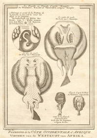
Côte occidentale de l'Afrique. W Africa.Senegal Gambia rivers.D’ANVILLE 1751 mapJasper524.5(9.8k)See Sold PriceFeb 28, 2024
West African Fish. Filefish. Remora or suckerfish. Ocean Sunfish. SCHLEY 1747Jasper524.5(9.8k)See Sold PriceFeb 28, 2024
Joyaux, ornemens de la côte de Guinée' West Africa jewels ornaments SCHLEY 1748Jasper524.5(9.8k)See Sold PriceFeb 28, 2024
Le Royaume d’Adel… Ajan & Zanguebar. Adal Ajuran. Kenya Tanzania. BONNE 1788 mapJasper524.5(9.8k)See Sold PriceFeb 28, 2024
Partie Occidentale de l’Afrique. West Africa coast Canary islands BONNE 1788 mapJasper524.5(9.8k)See Sold PriceFeb 28, 2024
West African fish. Torpedo or electric rays after Kempfer. SCHLEY 1747 printJasper524.5(9.8k)See Sold PriceFeb 28, 2024
Le Royaume d’Adel… Ajan & Zanguebar. Adal Ajuran. Kenya Tanzania. BONNE 1790 mapJasper524.5(9.8k)See Sold PriceFeb 28, 2024
Coste Occidentale d’Afrique…' Namibia South Africa Angola coast BELLIN 1746 mapJasper524.5(9.8k)See Sold PriceFeb 28, 2024
Jules Verne, De La Terre a La Lune, Au Steamer Red MacaronLion and Unicorn4.8(1.9k)See Sold PriceMar 10, 2024
![[Maps] Berthelot, Côtes de Terre Ferme... First Image](https://p1.liveauctioneers.com/1306/149407/75466432_1_x.jpg?height=282&quality=95&version=1567670607&width=282)

![[Maps] Berthelot, Côtes de Terre Ferme... First Image](https://p1.liveauctioneers.com/1306/149407/75466432_1_x.jpg?height=282&quality=1&version=1567670607&width=282)


![[Maps] Berthelot, Côtes de Terre Ferme... (1 of 2)](https://p1.liveauctioneers.com/1306/149407/75466432_1_x.jpg?height=282&quality=70&version=1567670607)


![[MAP] SANSON, NICOLAS Partie de Terre Ferme ou so (1 of 1)](https://p1.liveauctioneers.com/292/902/394452_1_x.jpg?height=282&quality=70)


![[MAP] DELISLE, GUILLAUME Carte de la Terre Ferme (1 of 1)](https://p1.liveauctioneers.com/292/8142/1390877_1_x.jpg?height=282&quality=70)


![[MAPS]. DUFOUR, Auguste-Henri (1795-1865). Bound Volume of ... (1 of 2)](https://p1.liveauctioneers.com/928/318880/171361279_1_x.jpg?height=282&quality=70&version=1707501302)