ATLAS of ANTIENT GEOGRAPHY by SAMUEL BUTLER 1843John McInnis Auctioneers,LLC4.6(502)See Sold PriceFeb 24, 2024
18TH C. ANTIQUE MAP: FRENCH & INDIAN WAR, FRAMEDThomaston Place Auction Galleries4.4(386)See Sold PriceFeb 24, 2024
Rand McNally Railroad Map Cabinet w/ 21 Railroad MapsRail & Road Auctions4.6(165)See Sold PriceMar 08, 2024
Keith Haring - Ink on New York Map, Best Buddies, Inscribed, Signed, and DatedSapphire Auction Gallery4(67)See Sold PriceMar 02, 2024
LATE 17TH C. FRENCH MAP OF THE NEW WORLD BY ALEXIS-HUBERT JAILLOT (1632-1712)Thomaston Place Auction Galleries4.4(386)See Sold PriceFeb 24, 2024
Central Railroad of New Jersey Map of Sandy Hook Route-ca. 1903JM Hobby Supply and Railroad Artifact Auctions4.4(126)See Sold PriceFeb 24, 2024
Lot of Six Mixed Atlas Box Cars-HO Scale-New in BoxJM Hobby Supply and Railroad Artifact Auctions4.4(126)See Sold PriceFeb 25, 2024
Rand McNally/Santa Fe Railroad Map of Iowa-1912JM Hobby Supply and Railroad Artifact Auctions4.4(126)See Sold PriceFeb 24, 2024
NICOLAES VISSCHER (NETHERLANDS, 1618-1709) MAP OF THE NEW WORLDThomaston Place Auction Galleries4.4(386)See Sold PriceFeb 24, 2024
17TH C. WORLD MAP BY NICOLAES VISSCHER (NETHERLANDS, 1618-1709)Thomaston Place Auction Galleries4.4(386)See Sold PriceFeb 24, 2024
Lot of Six Mixed Atlas Cabooses-HO Scale-New in BoxJM Hobby Supply and Railroad Artifact Auctions4.4(126)See Sold PriceFeb 25, 2024
SoldMap Plan of Roads of Toulon, 1759A map plan of "The Roads of Toulon with the adjacent Country", printed in 1759 for Gentleman's Magazine (Jolly Gent127). Fine condition, folds as issued. Measures 11.25 x 8". No Reserve: This lot starSee Sold Price
Tindal: Plan of Toulon With a View of Its Road, 1740Map: Plan of Toulon, With a View of Its Road, and the Situation Of Its Towns, &C. Publication Date: 1740 Authors: TINDAL, BASIRE, J. Publisher: TINDAL Size: Folio – 14.00 H x 18.00 W Inches "one ofSee Sold Price
SoldJ Basire: Plan of Toulon 1740Map: Plan of Toulon, With a View of Its Road, and the Situation Of Its Towns Maker: J Basire Publishing: Tindal: Boston Date: 1740 Size: 14 x 18 inches From Tindal's continuation of Rapin de Thoyros'See Sold Price
SoldJ. Basire Map [Map of Toulon, Italy]J. Basire (cartographer) map of Toulon, Sicily. Title 'Plan de Toulon' (Plan of Toulon, with a View of its Road, and the Situation of its Towns). Circa 1729. Measures 21.125-in. x 22.125-in. sheet sizSee Sold Price
Plan of Toulon, With a View of Its Road, and thePublication Date: 1740 Title: Plan of Toulon, With a View of Its Road, and the Situation Of Its Towns, &C. Cartographer: BASIRE, J. Publisher: TINDAL Height: 14 Width: 18 "one of the strongest and mosSee Sold Price
Plan of Toulon, With a View of Its Road, and thePublication Date: 1740 Title: Plan of Toulon, With a View of Its Road, and the Situation Of Its Towns, &C. Cartographer: BASIRE, J. Publisher: TINDAL Height: 14 Width: 18 "one of the strongest and mosSee Sold Price
Jefferys: Antique Map, City Plan of Toulon France, 1774Title/Content of Map: Plan of the City and Harbour of Toulon Date Printed: 1774 Cartographer: Jefferys, Thomas Size (inches): 8 x 11 Nice antique copperplate-engraved plan from 1774 of the Vauban-stylSee Sold Price
[maps] Nolin, Plan de ToulonJean Baptiste Nolin, Plan de Toulon. 1707. Incisione in rame in coloritura. mm 440x475. Foglio: mm510x545. Titolo impresso in alto al centro. Sotto, entro cartiglio, dettaglio del porto con scalaSee Sold Price
SoldCary (John) - Survey of other High Roads from Londonengraved title, folding map, 1 plan and 80 road maps (on 20 leaves), all hand-coloured, a few faint spots and minor surface soiling, contemporary tree calf, gilt, rebacked in modern calf, rubbed, cornSee Sold Price
SoldHurd: Antique Map of Venezuelan & Aruban Ports, 1817Title/Content of Map: Plan of Puerto Cabello / The Road of La Guayra, the Port of Caracas / The Bay of Barcelona / Orangestadt Harbour (Aruba) Cartographer: Capt. Hurd / British Admiralty Office PlaceSee Sold Price
Gulf Refining Co. 1929 Official Road Map No.4Title: Gulf Refining Co. 1929 Official Road Map No.4 Pennsylvania Publication Date: 1929 Cartographer: GOUSHA, H. M. CO. Publisher: GULF REFINING COMPANY Size: 15X22.75 Red and blue road map. City plaSee Sold Price
Sold1759 English map A Plan of Quebec1759 English hand colored map "A Plan of Quebec" published by the Universal Magazine, overall size 8 1/8" x 10", unframedSee Sold Price
Antique Harbour Plan - Map of Bay of Toulon - France, Marseille - MediterraneanTitle/Artist: Antique Harbour Plan - Map of Bay of Toulon - France, Marseille - Mediterranean Date: 1764 Material: Paper Dimensions: 17 cm x 23 cm Additional Information: Original hand-colored copperSee Sold Price
SoldSix Antique English Maps and PlansSix Antique English Maps and Plans , incl. four John Ogilby road maps, 17th c. (13 3/4 in. x 17 in.); and two plates of London showing Christopher Wren and John Evelyn's designs for the rebuilding ofSee Sold Price
Ireland by John Thomson. Coach roads 1817 old antique vintage map plan chartTitle: "Ireland" by John Thomson. Coach roads 1817 old antique vintage map plan chart Description: Ireland' by Drawn & engraved by Samuel John Neele for John Thomson's "New General Atlas" (Published iSee Sold Price
Thomson: Antique Map of Ireland, 1817TITLE/CONTENT OF MAP: 'Ireland' Coach roads 1817 old antique vintage map plan chart DATE PRINTED: 1817 IMAGE SIZE: Approx 64.0 x 53.0cm, 25.25 x 20.75 inches (Large); Please note that this is a foldinSee Sold Price
Thomson: Antique Map of Ireland, 1817Title/Content of Map: 'Ireland' Coach roads 1817 old antique vintage map plan chart Date Printed: 1817 Image Size: Approx 64.0 x 53.0cm, 25.25 x 20.75 inches (Large); Please note that this is a foldinSee Sold Price
Sold1759 Gentleman's Magazine Prussian war w/ Maps Plan1759 Gentleman's Magazine Prussian war w/ Maps Plan Deaf Chair. “Gentleman’s Magazine for August 1759, complete, 48 pages and three engravings: one a map of Westphalia, another of troop formationSee Sold Price
Thomson: Antique Map of Ireland, 1817Title/Content of Map: Ireland by John Thomson. Coach roads 1817 old antique vintage map plan chart. This map is folding hence the centrefold line may show on the image below Date Printed: 1817 Image SSee Sold Price
SoldThe Seat of War in the Southern Part of France......extending from THE ALPS, to the PYRENEES, with PLANS of the CITY ROADS and HARBOUR of TOULON, (London: Robert Sayer, 1793), copperplate engraving with color. Loose behind mat, unframed. Sheet 20.75See Sold Price
SDUK A good group of maps of EuropeSociety For The Diffusion Of Useful Knowledge (The) A group of maps of Europe,map of the Continent, city plans of Constantinople, Toulon and Munich, national and regional maps of the British ISee Sold Price
SoldFEUR Society For The Diffusion Of Useful KnowledgeFEUR Society For The Diffusion Of Useful Knowledge (The),A group of maps of Europe, map of the Continent, city plans of Constantinople, Toulon and Munich, national and regional maps of the BriSee Sold Price
SoldA small, mixed group of maps and town plans of EnBritish Isles.- A small, mixed group of maps and town plans of England and Scotland, including several of Kent and the Isle of Thannet, the Isle of White, road maps and town plans, including TSee Sold Price
Proposed THAMES EMBANKMENT road & railway. RetainsTITLE/CONTENT OF MAP: 'Plan and Section of Proposed Thames Embankment and Railway with a public carriage road from Whitehall to Blackfriars' By 1855 there had been many proposals to embank the Thames,See Sold Price
1963 J.F.K. for US PRESIDENT RE-ELECTION MATERIALJohn McInnis Auctioneers,LLC4.6(502)See Sold PriceFeb 25, 2024
Group of Lake Shore & Michigan Southern Railroad PaperRail & Road Auctions4.6(165)See Sold PriceMar 07, 2024
Group of Ten Railroad Photographs, Maps, and Prints - New Jersey, Long Island, and New YorkRail & Road Auctions4.6(165)See Sold PriceMar 07, 2024
1887 Appletons' General Guide to the United State and Canada Part IIRail & Road Auctions4.6(165)See Sold PriceMar 08, 2024
1711 GREEK BIBLE ILLUSTRATED w/ MAPS VELLUM BOUND antique NEW TESTAMENTJasper524.5(9.8k)See Sold PriceFeb 27, 2024
West Africa by Arrowsmith & Lewis 1812 old antique vintage map plan chartJasper524.5(9.8k)See Sold PriceFeb 28, 2024
AFRICA. Pre 'Scramble for Africa'. BARTHOLOMEW 1876 old antique map plan chartJasper524.5(9.8k)See Sold PriceFeb 28, 2024
Carte d'Afrique. Africa Soudan Zanzibar. LAPIE 1831 old antique map plan chartJasper524.5(9.8k)See Sold PriceFeb 28, 2024
Western Sahara. Africa 1885 old antique vintage map plan chartJasper524.5(9.8k)See Sold PriceFeb 28, 2024
AFRICA. Africa. Britannica 9th edition 1898 old antique vintage map plan chartJasper524.5(9.8k)See Sold PriceFeb 28, 2024
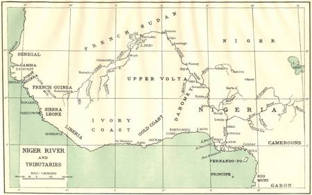
AFRICA. Niger River and Tributaries 1936 old vintage map plan chartJasper524.5(9.8k)See Sold PriceFeb 28, 2024
AFRICA. French North Africa and Morocco 1907 old antique map plan chartJasper524.5(9.8k)See Sold PriceFeb 28, 2024
Showers of Red Dust. Africa. Sahara 1886 old antique vintage map plan chartJasper524.5(9.8k)See Sold PriceFeb 28, 2024
Africa by Arrowsmith & Lewis 1812 old antique vintage map plan chartJasper524.5(9.8k)See Sold PriceFeb 28, 2024


![J. Basire Map [Map of Toulon, Italy] (1 of 2)](https://p1.liveauctioneers.com/5755/147592/74586283_1_x.jpg?height=282&quality=70&version=1565302309)


![[maps] Nolin, Plan de Toulon (1 of 1)](https://p1.liveauctioneers.com/1306/122788/62497223_1_x.jpg?height=282&quality=70&version=1527839290)