Map of US Military Railroad, Julius Bien 1866 Steel EngMap of United States Military Railroad showing the railroad operated during the war from 1862-1866 as military lines.. col., steel engraved. NY: Julius Bien, 1866100 mile scaleDimensions: 25" X 38"InvSee Sold Price
Map of United States Military Railroad Julius Bein,Map of United States Military Railroad showing the railroad operated during the war from 1862-1866 as military lines.. col., steel engraved. NY: Julius Bien, 1866100 mile scaleDimensions: 25" X 38"InvSee Sold Price
SoldMap of United States Military Railroad Julius BeinMap of United States Military Railroad showing the railroad operated during the war from 1862-1866 as military lines.. col., steel engraved. NY: Julius Bien, 1866100 mile scaleDimensions: 25" X 38"InvSee Sold Price
Map of United States Military Railroad Julius Bein,Map of United States Military Railroad showing the railroad operated during the war from 1862-1866 as military lines.. col., steel engraved. NY: Julius Bien, 1866100 mile scaleDimensions: 25" X 38"InvSee Sold Price
Map of United States Military Railroad Julius BeinMap of United States Military Railroad showing the railroad operated during the war from 1862-1866 as military lines.. col., steel engraved. NY: Julius Bien, 1866100 mile scaleDimensions: 25" X 38"InvSee Sold Price
Definitive Railroad Map of the Civil War SouthMcCallum, D. C. Map of United States Military Rail Roads... Lithographed map. Julius Bien, 1866. 30" x 40" sheet. "showing the rail roads operated during the war from 1862 - 1866, as military lines, uSee Sold Price
SoldCivil War Miltary Map Antique Lithograph GroupingGrouping includes (4) Civil War military map Antique lithographs by Julius Bien & Co published in the Atlas to Accompany the Official Records of the Union and Confederate Armies. Includes Map Plate #8See Sold Price
SoldCivil War Military Map Antique Lithograph GroupingGrouping includes (4) Civil War military map Antique lithographs by Julius Bien & Co published in the Atlas to Accompany the Official Records of the Union and Confederate Armies. Including Plate #133See Sold Price
Sold3 litho maps of Colorado (2 color), Hayden, 1877.[Western US]. 3 Maps. Lithographed by Julius Bien (2 in color). Scale = 12 miles: 1 inch. 25 1/4 x 34 3/4 in. ++ Economic Map Of Colorado. Color. ++ Drainage Map Of Colorado. ++ Geological Map Of ColoSee Sold Price
SoldAntique Civil War Military Map1865 Civil War Map of General Sherman's March through Georgia and the Carolinas. Printed by Julius Bien and Co. Litho NY. H18 1/2" W29 1/2"See Sold Price
Important Civil War Presentation Copy Military Map 1869Military maps illustrating the operations of the armies of the Potomac and James, May 4th, 1864- April 9th,1865, 17 Double page lithograph plates.. NY: Julius Bien, 1869. Elephant fol, OV. Note: PreseSee Sold Price
SoldVintage Railroad Map of Pennsylvania,1890Railroad Map of Pennsylvania Established by the Department of Internal Affairs of Pennsylvania, 1890, vintage lithographic map in colors, drawn by J. Sutton Wall, published by Julius Bien & Co., printSee Sold Price
SoldVintage Railroad Map of Pennsylvania,1890Railroad Map of Pennsylvania Established by the Department of Internal Affairs of Pennsylvania, 1890, vintage lithographic map in colors, drawn by J. Sutton Wall, published by Julius Bien & Co., printSee Sold Price
Important Civil War Presentation Copy Military Maps ofMilitary maps illustrating the operations of the armies of the Potomac and James, May 4th, 1864- April 9th,1865, 17 Double page lithograph plates.. NY: Julius Bien, 1869. Elephant fol, OV. Note: PreseSee Sold Price
Important Civil War Presentation Copy Military Maps ofMilitary maps illustrating the operations of the armies of the Potomac and James, May 4th, 1864- April 9th,1865, 17 Double page lithograph plates.. NY: Julius Bien, 1869. Elephant fol, OV. Note: PreseSee Sold Price
SoldImportant Civil War Presentation Copy Military MapsMilitary maps illustrating the operations of the armies of the Potomac and James, May 4th, 1864- April 9th, 1865, 17 Double page lithograph plates.. NY: Julius Bien, 1869. Elephant fol, OV. Note: PresSee Sold Price
SoldBien: Antique Map of the US, Union & Confederate, 1895Item: Map of the United States of America showing the boundaries of the Union and Confederate geographical divisions and departments, Dec. 31, 1860 Maker: Julius Bien & Co Size: 28 x 17 inches Date: 1See Sold Price
US GLO Map of the State of Mississippi 1878United States General Land Office. J.A. Williamson, Commissioner; Charles Roser, principal draughtsman; Photo-lithograph, Julius Bien, NY. State of Mississippi, 1878. Color printed photo-lithograph WaSee Sold Price
Sold[Cartography]. Map Of United States Military Rail[Cartography]. Map Of United States Military Rail Roads: Showing The Rail Roads Operated During The War From 1862-1866, As Military Lines. Prepared under Brig. Gen. D. C. McCallum. NY: J. Bien, 1866.See Sold Price
SoldAntique Coast Survey Map of Coastal LouisianaAntique Coast Survey Map of Coastal Louisiana , "U.S. Coast Survey, A.D. Bache Superintendant, Sketch II...", 1856, lithograph printed by Julius Bien, NY, with later hand-coloring, showing VermillionSee Sold Price
Sold16 maps General Land Office 1865 report.[U.S. Railroads]. 16 maps from the General Land Office's Annual Report for 1865. 39th Cong, 1st Sess. [Wash]: c.1866. Folio. Half leather & cloth. All maps except Washington Territory have some originSee Sold Price
SoldMap of the Cherokee Nation cop. by R.L. McAlpine,Map of Cherokee Nation.U.S. Department of the Interior. Commission to the Five Civilized Tribes, 7th Annual Report, comp. by R.L. McAlpine,. Indian Territory, Col. Steel engraving. NY: Julius Bien & CSee Sold Price
1901 Map showing progress of allotment in Indian CreekMap showing progress of allotment in Creek Nation- Exhibit, col,. comp. and drawn by C.H. Dana. NY: U.S. Department of the Interior, Julius Bien Photo Lithograph, 190120 mile scaleDimensions: 24 1/4"See Sold Price
1901 Map showing progress of allotment in Indian CreekMap showing progress of allotment in Creek Nation- Exhibit, col,. comp. and drawn by C.H. Dana. NY: U.S. Department of the Interior, Julius Bien Photo Lithograph, 190120 mile scaleDimensions: 24 1/4"See Sold Price
Crawfordsville and Southwestern RY First Mortgage Bond Prospectus Book-1872JM Hobby Supply and Railroad Artifact Auctions4.4(127)See Sold PriceFeb 24, 2024
1875 Rand Avery and Co. Map of Express Companies and Railroads of the USA and CanadaJM Hobby Supply and Railroad Artifact Auctions4.4(127)See Sold PriceFeb 24, 2024
American Express/New York Central Railroad Map of the United States-1934JM Hobby Supply and Railroad Artifact Auctions4.4(127)See Sold PriceFeb 24, 2024
Central Railroad of New Jersey Map of Sandy Hook Route-ca. 1903JM Hobby Supply and Railroad Artifact Auctions4.4(127)See Sold PriceFeb 24, 2024
Cincinnati Hamilton and Dayton RR Map -USGC 1889JM Hobby Supply and Railroad Artifact Auctions4.4(127)See Sold PriceFeb 24, 2024
Crams Township and Railroad Map of New York-1890JM Hobby Supply and Railroad Artifact Auctions4.4(127)See Sold PriceFeb 24, 2024
Northern Pacific RR Washington and Northern Idaho Map Folder-1941JM Hobby Supply and Railroad Artifact Auctions4.4(127)See Sold PriceFeb 24, 2024
Rand McNally Railroad Map of Colorado-1929JM Hobby Supply and Railroad Artifact Auctions4.4(127)See Sold PriceFeb 24, 2024
Rand McNally Township County and Railroad Map of Illinois-1879JM Hobby Supply and Railroad Artifact Auctions4.4(127)See Sold PriceFeb 24, 2024
Rand McNally Township County and Railroad Map of Indiana-1880JM Hobby Supply and Railroad Artifact Auctions4.4(127)See Sold PriceFeb 24, 2024
Rand McNally/Santa Fe Railroad Map of Iowa-1912JM Hobby Supply and Railroad Artifact Auctions4.4(127)See Sold PriceFeb 24, 2024
Rock Island RR Iowa and Minnesota Lakes Country Brochure-1926JM Hobby Supply and Railroad Artifact Auctions4.4(127)See Sold PriceFeb 24, 2024
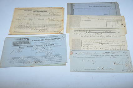
Bills of Lading, Checks, other Paper from 1840s-1860s-Eastern USA RailroadsJM Hobby Supply and Railroad Artifact Auctions4.4(127)See Sold PriceFeb 24, 2024
Mahanoy and Broad Mountain RR 1866 PassJM Hobby Supply and Railroad Artifact Auctions4.4(127)See Sold PriceFeb 24, 2024
Large Steel Railroad Crossing Sign with CateyesJM Hobby Supply and Railroad Artifact Auctions4.4(127)See Sold PriceFeb 24, 2024
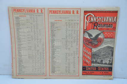
Pennsylvania Railroad July 8, 1885 Public TimetableJM Hobby Supply and Railroad Artifact Auctions4.4(127)See Sold PriceFeb 24, 2024
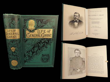
1885 General US GRANT 1st ed President Military Biography CIVIL WAR IllustratedSchilb Antiquarian Rare Books4.8(428)See Sold PriceMar 10, 2024
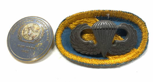
2 Military Pins, US Army Sterling Silver & 1946 UNThe Benefit Shop Foundation Inc.4.3(2.9k)See Sold PriceFeb 28, 2024
Thirty Pieces of Lackawanna Railroad Ephemera - Chief Engineer Timebook, Map, Public Timetables,Rail & Road Auctions4.6(165)See Sold PriceMar 07, 2024
Collection of Allied Military Silk Printed Maps, WWII Era and LaterMaterial Culture4.6(778)See Sold PriceFeb 29, 2024
Rand McNally Railroad Map Cabinet w/ 21 Railroad MapsRail & Road Auctions4.6(165)See Sold PriceMar 08, 2024
Group of 30+ U.S. Military Patches and MoreMatthew Bullock Auctioneers4.7(1.8k)See Sold PriceFeb 24, 2024
Vintage Vertex "Dirty Dozen" Military WristwatchCollectible Auction LLC 4.4(69)See Sold PriceFeb 24, 2024
Bell & Ross BR 03-92 Military Type with Date Wristwatch with Bell & Ross Box and Bell & Ross Owner'sCollectible Auction LLC 4.4(69)See Sold PriceFeb 24, 2024


![[Cartography]. Map Of United States Military Rail (1 of 0)](https://p1.liveauctioneers.com/dist/images/placeholder.jpg?height=282&quality=70)