Marc Chagall-Limited Edition -Paris Opera Ceiling after ChagallArt Legacy Auctions4.5(223)See Sold PriceFeb 24, 2024
Salvador Dali Pantagruel Limited Edition Lithograph Hand signed and numberedArt Legacy Auctions4.5(223)See Sold PriceFeb 24, 2024
Pablo Picasso Bouquet of Peace Collection Domaine Picasso Limited Edition on paper.Art Legacy Auctions4.5(223)See Sold PriceFeb 24, 2024
A RARE MAXFIELD PARRISH JACK AND THE BEANSTALK PRINTSoulis Auctions4.8(953)See Sold PriceFeb 24, 2024
LARGE MECHANICAL PRINT 'STARS' AFTER MAXFIELD PARRISHSoulis Auctions4.8(953)See Sold PriceFeb 24, 2024
Heinrich Aldegrever, etc. 15 old master prints. 16th-17th centuries. Aldegrever works include "ManTremont Auctions4.5(297)See Sold PriceFeb 25, 2024
1901 Map showing progress of allotment in Indian CreekMap showing progress of allotment in Creek Nation- Exhibit, col,. comp. and drawn by C.H. Dana. NY: U.S. Department of the Interior, Julius Bien Photo Lithograph, 190120 mile scaleDimensions: 24 1/4"See Sold Price
1901 Map showing progress of allotment in Indian CreekMap showing progress of allotment in Creek Nation- Exhibit, col,. comp. and drawn by C.H. Dana. NY: U.S. Department of the Interior, Julius Bien Photo Lithograph, 190120 mile scaleDimensions: 24 1/4"See Sold Price
1901 Map showing progress of allotment in Indian CreekMap showing progress of allotment in Creek Nation- Exhibit, col,. comp. and drawn by C.H. Dana. NY: U.S. Department of the Interior, Julius Bien Photo Lithograph, 190120 mile scaleDimensions: 24 1/4"See Sold Price
1901 Map showing progress of allotment in Indian CreekMap showing progress of allotment in Creek Nation- Exhibit, col,. comp. and drawn by C.H. Dana. NY: U.S. Department of the Interior, Julius Bien Photo Lithograph, 190120 mile scaleDimensions: 24 1/4"See Sold Price
Sold1901 Map showing progress of allotment in Indian CreekMap showing progress of allotment in Creek Nation- Exhibit, col,. comp. and drawn by C.H. Dana. NY: U.S. Department of the Interior, Julius Bien Photo Lithograph, 190120 mile scaleDimensions: 24 1/4"See Sold Price
SoldAN ANTIQUE MAP, "Department of the Interior ComissionAN ANTIQUE MAP, "Department of the Interior Comission to the Five Civilized Tribes, Map Showing Progress of Allotment in the Creek Nation," 1902, color engraving on paper, ninth annual report commissiSee Sold Price
1901 Bien Seminole Nation Map -- Map of Seminole NationTitle/Content of Map: 1901 Bien Seminole Nation Map -- Map of Seminole Nation Showing Progress of Allotment Cartographer: J Bien & Co. Size: 19 x 10 in. This map shows in great detail the Allotments mSee Sold Price
SoldAN ANTIQUE MAP, "Department of the Interior CommissionAN ANTIQUE MAP, "Department of the Interior Commission to the Five Civilized Tribes, Map Showing Progress of Allotment in the Cherokee Nation," 1903, color lithograph on paper, tenth annualSee Sold Price
Bien: Antique Map of Seminole Nation, 1901Title/Content of Map: 1901 Bien Seminole Nation Map -- Map of Seminole Nation Showing Progress of Allotment Date Printed: 1901, Washington Cartographer: J Bien & Co. Size: 19 x 10 in. This map shows iSee Sold Price
Sold1901 Bien Seminole Nation Map -- Map of Seminole NationTitle/Content of Map: 1901 Bien Seminole Nation Map -- Map of Seminole Nation Showing Progress of Allotment Date: 1901, Washington Cartographer: J Bien & Co. Size: 19 x 10 in. This map shows in greatSee Sold Price
1901 Bien Seminole Nation Map -- Map of Seminole NationTitle/Content of Map: 1901 Bien Seminole Nation Map -- Map of Seminole Nation Showing Progress of Allotment Date Printed: 1901, Washington Cartographer: J Bien & Co. Size: 19 x 10 in. This map shows iSee Sold Price
Antique 1901 Bien Seminole Nation MapTitle/Content of Map: 1901 Bien Seminole Nation Map -- Map of Seminole Nation Showing Progress of Allotment Date Printed: 1901, Washington Cartographer: J Bien & Co. Size: 19 x 10 in. This map shows iSee Sold Price
1901 Bien Seminole Nation Map -- Map of Seminole NationTitle/Content of Map: 1901 Bien Seminole Nation Map -- Map of Seminole Nation Showing Progress of Allotment Date: 1901, Washington Cartographer: J Bien & Co. Size: 19 x 10 in. This map shows in greatSee Sold Price
SoldU.S. MAP OF KANSAS AND NEBRASKA TERRITORIES, 1860"Map showing the progress of Public surveys in the Territories of Kansas and Nebraska, to accompany the Annual Report of the Surveyor General, 1860, includes rivers and streams, many Indian reservatioSee Sold Price
SoldU.S. MAP OF KANSAS AND NEBRASKA TERRITORIES, 1860"Map showing the progress of Public surveys in the Territories of Kansas and Nebraska, to accompany the Annual Report of the Surveyor General, 1860, includes rivers and streams, many Indian reservatioSee Sold Price
Sold1901 Report Maps on Seminole, Choctaw, Cherokee et[Maps]. Creek & Seminole Nations, Choctaw Nation, Chickasaw Nation, Cherokee Nation, Indian Territory (2), Creek Nation, & Seminole Nation. All maps from 1901 Report on Five Civilized Tribes. Folded;See Sold Price
Extremely scarce RR map of Utah from 1910 Cram Std. Amer. Railway atlasImpossibly scarce, large format railroad map of Utah, showing counties, railroad lines, towns, mines, rivers, township surveys, Indian reservations, lakes, mountains, creeks, waterfalls, and a host ofSee Sold Price
SoldAN ANTIQUE CADASTRAL MAP, "Montgomery County, " CIRCAAN ANTIQUE CADASTRAL MAP, "Montgomery County, " CIRCA 1880, lithograph on paper, showing in the east Lake Creek, Mill Creek, Indian Creek, in the west the San Jacinto River, the Houston GreaSee Sold Price
SoldOklahoma, Indian Terr., Indian Res, N.M.T. MapsProposed state of Oklahoma. General Land Office map 1906; Progress of survey and subdivision, Idnian Territory 1896; map showing Indian Reservations within the limits of the US - 1889; and map of theSee Sold Price
SoldMining claim map in Colorado 1901Heading: (Colorado) Author: Underhill, James Title: Map of portions of lower Clear Creek and Gilpin Counties showing mining claims in the vicinity of Idaho Springs, Colorado, prepared from official suSee Sold Price
Mining claim map in Colorado 1901Heading: (Colorado) Author: Underhill, James Title: Map of portions of lower Clear Creek and Gilpin Counties showing mining claims in the vicinity of Idaho Springs, Colorado, prepared from official suSee Sold Price
SoldAN ANTIQUE SURVEY MAP, "Map of the Indian Territory,AN ANTIQUE SURVEY MAP, "Map of the Indian Territory, Exhibit B," WASHINGTON D.C., June 30, 1902, color lithograph on paper, "Showing the progress and status of townsite surveys, under the direction ofSee Sold Price
Sold1802 Hand drawn map of GeorgiaHand drawn map of the State of Georgia, dated "8 month 12th 1802", showing the "Tennasee Government," Country of the Cherokees, Country of the Creek Nation of Indians, Seminoles, Chacktaws, etc. alongSee Sold Price
SoldAN ANTIQUE MAP, "Map showing Indian Reservations withinAN ANTIQUE MAP, "Map showing Indian Reservations within the limits of the United States," 1889, color lithograph on paper, "Compiled under the direction of the Hon. T.J. Morgan, Commissioner of IndianSee Sold Price
Lake Superior and Mississippi River RR 1869 Seven Percent Bonds Book/Report-1869JM Hobby Supply and Railroad Artifact Auctions4.4(127)See Sold PriceFeb 24, 2024
Rand McNally Railroad Map of Arizona-1909JM Hobby Supply and Railroad Artifact Auctions4.4(127)See Sold PriceFeb 24, 2024
Rand McNally Railroad Map of Washington-1906JM Hobby Supply and Railroad Artifact Auctions4.4(127)See Sold PriceFeb 24, 2024
Union Pacific RR Map of the United States-1926JM Hobby Supply and Railroad Artifact Auctions4.4(127)See Sold PriceFeb 24, 2024
1954 Pennsylvania Railroad Calendar-Pittsburgh Promotes ProgressJM Hobby Supply and Railroad Artifact Auctions4.4(127)See Sold PriceFeb 24, 2024
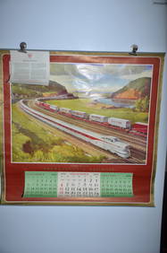
1956 Pennsylvania Railroad Calendar-Dynamic ProgressJM Hobby Supply and Railroad Artifact Auctions4.4(127)See Sold PriceFeb 24, 2024
RED INDIAN GASOLINE SINGLE 13.5" GLOBE LENS ON NARROW MILK GLASS BODY.Dan Morphy Auctions4.2(1.3k)See Sold PriceFeb 24, 2024
RED INDIAN MCCOLL-FRONTENAC PRODUCTS 30" PORCELAIN SIGN W/ NATIVE AMERICAN GRAPHIC.Dan Morphy Auctions4.2(1.3k)See Sold PriceFeb 24, 2024
RARE RED INDIAN MCCOLL-FRONTENAC PRODUCTS 42" PORCELAIN SIGN W/ ORIGINAL RING.Dan Morphy Auctions4.2(1.3k)See Sold PriceFeb 24, 2024
INDIAN GASOLINE PORCELAIN PUMP PLATE SIGN AGS 94.Dan Morphy Auctions4.2(1.3k)See Sold PriceFeb 24, 2024
18TH C. ANTIQUE MAP: FRENCH & INDIAN WAR, FRAMEDThomaston Place Auction Galleries4.4(393)See Sold PriceFeb 24, 2024
Vintage County Map Of NY State Plate EngravingThe Benefit Shop Foundation Inc.4.3(2.9k)See Sold PriceFeb 28, 2024
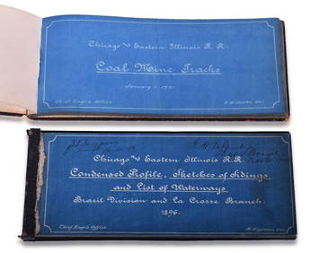
Chicago & Eastern Illinois Railroad 1901 Coal Mine Track and 1896 Brazil Division Track Chart BooksRail & Road Auctions4.6(165)See Sold PriceMar 08, 2024
Fred Harvey Railroad Souvenir Playing Cards - Indians and Train Smoke and Indians of the SouthwestRail & Road Auctions4.6(165)See Sold PriceMar 08, 2024
Hist. of Indian wars of the Far West - Massacres of the MountainsJasper524.5(9.9k)See Sold PriceFeb 27, 2024
Tour of the Dutch East Indies, with exceptional platesPBA Galleries4.7(385)See Sold PriceMar 07, 2024