ATLAS of ANTIENT GEOGRAPHY by SAMUEL BUTLER 1843John McInnis Auctioneers,LLC4.6(502)See Sold PriceFeb 24, 2024
18TH C. ANTIQUE MAP: FRENCH & INDIAN WAR, FRAMEDThomaston Place Auction Galleries4.4(386)See Sold PriceFeb 24, 2024
Rand McNally Railroad Map Cabinet w/ 21 Railroad MapsRail & Road Auctions4.6(165)See Sold PriceMar 08, 2024
Keith Haring - Ink on New York Map, Best Buddies, Inscribed, Signed, and DatedSapphire Auction Gallery4(67)See Sold PriceMar 02, 2024
LATE 17TH C. FRENCH MAP OF THE NEW WORLD BY ALEXIS-HUBERT JAILLOT (1632-1712)Thomaston Place Auction Galleries4.4(386)See Sold PriceFeb 24, 2024
Central Railroad of New Jersey Map of Sandy Hook Route-ca. 1903JM Hobby Supply and Railroad Artifact Auctions4.4(126)See Sold PriceFeb 24, 2024
Lot of Six Mixed Atlas Box Cars-HO Scale-New in BoxJM Hobby Supply and Railroad Artifact Auctions4.4(126)See Sold PriceFeb 25, 2024
Rand McNally/Santa Fe Railroad Map of Iowa-1912JM Hobby Supply and Railroad Artifact Auctions4.4(126)See Sold PriceFeb 24, 2024
NICOLAES VISSCHER (NETHERLANDS, 1618-1709) MAP OF THE NEW WORLDThomaston Place Auction Galleries4.4(386)See Sold PriceFeb 24, 2024
17TH C. WORLD MAP BY NICOLAES VISSCHER (NETHERLANDS, 1618-1709)Thomaston Place Auction Galleries4.4(386)See Sold PriceFeb 24, 2024
Lot of Six Mixed Atlas Cabooses-HO Scale-New in BoxJM Hobby Supply and Railroad Artifact Auctions4.4(126)See Sold PriceFeb 25, 2024
New York by Mitchell, 1872County Map of the State of New York. Large two-page format hand colored by county. Includes five inset maps: Troy, Albany, Harbor and Vicinity of New York, Buffalo and Rochester. Shows railroads, canaSee Sold Price
Sought-after 2-pg map of New York, Mitchell 1850Extremely detailed and large map of New York, hand-colored when published. Shows railroads, towns, rivers, canals, steamship routes, and more. Map is framed by population tables for counties and townsSee Sold Price
Sold2 Colton Pocket Maps, State of New York 1856 and2 Colton Pocket Maps, State of New York 1856 and Township Map of New York 1872-- Dimensions: ---See Sold Price
Sold1876 Mitchell Map of New York -- County Map of theReserve Reduced! Title/Content of Map: 1876 Mitchell Map of New York -- County Map of the State of New York Date: 1876 Philadelphia Cartographer: S Mitchell Size: 13.5 x 21.3 in. A very nice, large maSee Sold Price
Sold1878 Mitchell Map of New York and Brooklyn -- New YorkTitle/Content of Map: 1878 Mitchell Map of New York and Brooklyn -- New York and Brooklyn Date Printed: 1878, Philadelphia Cartographer: S Mitchell Size: 13.3 x 20.3 in. A very nice map of New York (MSee Sold Price
1877 Mitchell Map of New York and Brooklyn -- New YorkTitle/Content of Map: 1877 Mitchell Map of New York and Brooklyn -- New York and Brooklyn Cartographer: S Mitchell Year/Place: 1877 Philadelphia Size: 13.3 x 20.3 in. This is a very nice double page mSee Sold Price
Sold1887 Mitchell Map of New York City -- New York andTitle/Content of Map: 1887 Mitchell Map of New York City -- New York and Brooklyn Date: 1887, Philadelphia Cartographer: SS Mitchell Size: 13.5 x 21.1 in. This fascinating map of New York City area coSee Sold Price
SoldMitchell Map of New York -- City of New-YorkTitle/Content of Map: Mitchell Map of New York -- City of New-York Date: 1848, Philadelphia Cartographer: S Mitchell Size: 15.4 X 12.4 in. This is an outstanding map of New York, with focus on southerSee Sold Price
1858 Mitchell Map of New York to North Carolina -- No.Title: 1858 Mitchell Map of New York to North Carolina -- No. 11 Map of the Middle States and Part of the Southern… Date: 1858, Philadelphia Cartographer: S Mitchell Size: 16.8 x 10.4 in. AdditionalSee Sold Price
Sold1877 Mitchell Map of New York and Brooklyn -- New YorkTitle: 1877 Mitchell Map of New York and Brooklyn -- New York and Brooklyn Cartographer: S Mitchell Year / Place: 1877 Philadelphia Map Dimension (in.): 13.3 x 20.3 in. This is a very nice double pageSee Sold Price
Sold1839 Mitchell Map of New York to North Carolina -- No.Title/Content of Map: 1839 Mitchell Map of New York to North Carolina -- No. 11 Map of the Middle States and Part of Southern… Date: 1839 Philadelphia Cartographer: S Mitchell Size: 16.8 x 10.4 in.See Sold Price
Sold2 New York Pocket Maps - Mitchell, 1843 and Burr,2 New York Pocket Maps - Mitchell, 1843 and Burr, 1841-- Dimensions: --- US Shipping charge: $20See Sold Price
Sold2 New York Pocket Maps - Mitchell, 1843 and Burr,2 New York Pocket Maps - Mitchell, 1843 and Burr, 1841-- Dimensions: ---See Sold Price
Sold(6) MITCHELL & BRADLEY ATLAS MAPS NEW YORK, BOSTON(lot of 6) Unframed atlas maps, Samuel Augustus Mitchell (United States, 1790-1868), c.1884, approx 15.25"h, 23.25"w, including: (1) plan of Boston, with inset of Boston Harbor, (1) plan of the city oSee Sold Price
SoldMitchell: Map of City of New York, 1849An original steel engraved map of New York City published by Augustus Mitchell in 1849, with original hand coloring. Manhattan from about 37th St with Brooklyn and Williamsburg. Key to public buildingSee Sold Price
SoldMitchell: Antique Map of New York City, 1860Title/Content of Map: 1860 Mitchell Map of New York -- Plan of New York & c. Date Printed: 1860, Philadelphia Cartographer: S Mitchell Size: 13.5 x 10.5 in. An excellent map of lower Manhattan, EllisSee Sold Price
SoldMitchell: Antique Map of New York to North CarolinaTitle/Content of Map: 1852 Mitchell Map of New York to North Carolina -- No. 11 Map of the Middle States and Part of Southern… Date Printed: 1852 Philadelphia Cartographer: S Mitchell / CowperthwaitSee Sold Price
SoldMitchell: Antique Map of New York City, 1869Title/Content of Map: New York City by Mitchell Date Printed: 1869 Cartographer: Augustus S. Mitchell Material/Medium: Paper Size: 23" x 15" Condition: Excellent Hand colored engraved Map. Published iSee Sold Price
S.A. Mitchell: New Map of New York, 1846Map: A New Map of New York with Its Canals, Roads & Distances Cartographer: S. Augustus Mitchell Illustrator: H. Burroughs Edition: First Edition Publisher: S. Augustus Mitchell Date: 1846 Size: 11.75See Sold Price
SoldMitchell: Antique Map of New York State w/ city insetsCounty Map of the State of New York The beautifully detailed and colored county map of New York State from the 1870 edition of Mitchell's popular New General Atlas of the world. Framed by the vine motSee Sold Price
Sold1846 Augustus Mitchell Atlas: Maps Maine, New YorkNew Hampshire, Vermont, Connecticut, Rhose Island and New York City, Philadelphia 1846, intact, with covers, complete , 6 maps in bound folio with front and end papers, original covers, ownership inscSee Sold Price
Mitchell: New York and BrooklynMap: New York and Brooklyn (original Antique map) Maker: Mitchell, S. Augustus Publisher: S. Augustus Mitchell, Philadelphia Publishing Date: 1872 Size: 13.5 x 20.75 inches Elusive, hand-colored 2-pagSee Sold Price
SoldDated 1845 MapDated 1845 roll out map "The Empire State New York.....Published by Augustus Mitchell....Philadelphia". 50" x 40".See Sold Price
SoldPlan of New York, Mitchell 1860New York City with Green Point, Williamsburg, Brooklyn, Jersey City and Hoboken all labeled clearly. Original hand coloring. Collectible map with some faults so low reserve. From the 1864 Mitchell NewSee Sold Price
Crams Railroad Map of New York-1881JM Hobby Supply and Railroad Artifact Auctions4.4(126)See Sold PriceFeb 24, 2024
Crams Township and Railroad Map of New York-1890JM Hobby Supply and Railroad Artifact Auctions4.4(126)See Sold PriceFeb 24, 2024
Erie Railway Tourist Book/Magazine-1874JM Hobby Supply and Railroad Artifact Auctions4.4(126)See Sold PriceFeb 24, 2024
19thc Engraving, High Falls, Trenton Falls New YorkConnoisseur Auctions4(333)See Sold PriceFeb 24, 2024
Vintage County Map Of NY State Plate EngravingThe Benefit Shop Foundation Inc.4.3(2.9k)See Sold PriceFeb 28, 2024
1872 Holy BIBLE & Hitchcock Analysis Gruden Concordance Theology MAPS Holy LandSchilb Antiquarian Rare Books4.8(421)See Sold PriceMar 31, 2024
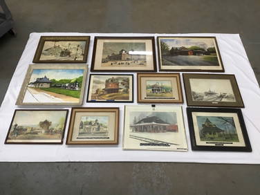
Eleven Railroad Station Art Prints, Lithographs, and Painting - Grand Central Depot, GettsyburgRail & Road Auctions4.6(165)See Sold PriceMar 07, 2024
1855 Map of New York & Erie Railroad and 1917 Trespassing On Railway Property Is A MisdemeanorRail & Road Auctions4.6(165)See Sold PriceMar 07, 2024
Attributed Howard Chandler Christy W/C Woodland BathersHeritage Gallery Auctions4.4(56)See Sold PriceMar 10, 2024
Keith Haring - Ink on New York Map, Best Buddies, Inscribed, Signed, and DatedSapphire Auction Gallery4(67)See Sold PriceMar 02, 2024
Louis Kronberg (NY,FL,MA,1872-1965) pastel painting antiqueBroward Auction Gallery4.8(277)See Sold PriceMay 05, 2024
Keith Haring Artwork Signed on a Shell Oil New York Road Map 18 in. x 24 in.Donny Malone Auctions4.5(1.7k)See Sold PriceMar 04, 2024
1900 THOMAS HENRY HUXLEY SKETCH OF HIS LIFE & WORK P. CHALMERS MITCHELL antiqueJasper524.5(9.8k)See Sold PriceFeb 27, 2024
Mitchell Robinson Signed Jersey PSA/DNA New York Knicks Autographed3 Kings Auction4.3(194)See Sold PriceFeb 24, 2024
Mitchell Robinson Signed Jersey PSA/DNA New York Knicks Autographed3 Kings Auction4.3(194)See Sold PriceFeb 26, 2024
19thc Engraving Castellated Rock, Northern CaliforniaConnoisseur Auctions4(333)See Sold PriceMar 16, 2024
Louis Kronberg (New York, Florida, Massachusetts, 1872 - 1965) pastel on paper. art work measuresJoshua Kodner4.2(386)See Sold PriceMar 09, 2024
Dan Budnik, Collection of eleven photographsLos Angeles Modern Auctions4.4(24)See Sold PriceMar 08, 2024