ATLAS of ANTIENT GEOGRAPHY by SAMUEL BUTLER 1843John McInnis Auctioneers,LLC4.6(504)See Sold PriceFeb 24, 2024
18TH C. ANTIQUE MAP: FRENCH & INDIAN WAR, FRAMEDThomaston Place Auction Galleries4.4(389)See Sold PriceFeb 24, 2024
Rand McNally Railroad Map Cabinet w/ 21 Railroad MapsRail & Road Auctions4.6(165)See Sold PriceMar 08, 2024
Keith Haring - Ink on New York Map, Best Buddies, Inscribed, Signed, and DatedSapphire Auction Gallery4.1(67)See Sold PriceMar 02, 2024
LATE 17TH C. FRENCH MAP OF THE NEW WORLD BY ALEXIS-HUBERT JAILLOT (1632-1712)Thomaston Place Auction Galleries4.4(389)See Sold PriceFeb 24, 2024
Central Railroad of New Jersey Map of Sandy Hook Route-ca. 1903JM Hobby Supply and Railroad Artifact Auctions4.4(126)See Sold PriceFeb 24, 2024
Lot of Six Mixed Atlas Box Cars-HO Scale-New in BoxJM Hobby Supply and Railroad Artifact Auctions4.4(126)See Sold PriceFeb 25, 2024
Rand McNally/Santa Fe Railroad Map of Iowa-1912JM Hobby Supply and Railroad Artifact Auctions4.4(126)See Sold PriceFeb 24, 2024
NICOLAES VISSCHER (NETHERLANDS, 1618-1709) MAP OF THE NEW WORLDThomaston Place Auction Galleries4.4(389)See Sold PriceFeb 24, 2024
17TH C. WORLD MAP BY NICOLAES VISSCHER (NETHERLANDS, 1618-1709)Thomaston Place Auction Galleries4.4(389)See Sold PriceFeb 24, 2024
Lot of Six Mixed Atlas Cabooses-HO Scale-New in BoxJM Hobby Supply and Railroad Artifact Auctions4.4(126)See Sold PriceFeb 25, 2024
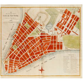
SoldPlan of New York, Mitchell 1860New York City with Green Point, Williamsburg, Brooklyn, Jersey City and Hoboken all labeled clearly. Original hand coloring. Collectible map with some faults so low reserve. From the 1864 Mitchell NewSee Sold Price
SoldMitchell: Antique Map of New York City, 1860Title/Content of Map: 1860 Mitchell Map of New York -- Plan of New York & c. Date Printed: 1860, Philadelphia Cartographer: S Mitchell Size: 13.5 x 10.5 in. An excellent map of lower Manhattan, EllisSee Sold Price
SoldPlan of New York &C.Title: Plan of New York &C. Date: 1860 ca. Cartographer: MITCHELL, S. AUGUSTUS, JR. Size: 12.75 X 10.5 Map 23 from a Mitchell atlas but not the New General. From the Battery north to 45th St. Floral bSee Sold Price
SoldMap, "Plan of New York & Co" 1860, showing ManhattanMap, "Plan of New York & Co" 1860, showing Manhattan (below 45th street), Brooklyn, Williamsburg, Green Point & Jersey City, map is 13.75" by 11.25". Notice: Please note that our auctions will continuSee Sold Price
Desirable “Plan of New York City” by Mitchell, 1860One of the more collectible and attractive atlas maps of New York City to appear in the nineteenth century. From Mitchell’s New General Atlas (1865 edition). Shows southern Manhattan below 45thSee Sold Price
SoldPlan of New Orleans, Mitchell 1860Extremely wide margins. Close up view of the plan of New Orleans. Features the distinctive and attractive flower frame used by Mitchell in the 1860s. Light toning to edges. Stain at lower left margin.See Sold Price
Plan of New Orleans, Mitchell 1860Extremely wide margins. Close up view of the plan of New Orleans. Features the distinctive and attractive flower frame used by Mitchell in the 1860s. Light toning to edges. Stain at lower left margin.See Sold Price
SoldTHREE STICK BAROMETERS; two by Henry J. Green, BrooklynCOLLECTION OF WORLD AND OTHER MAPS; including: Crane's Political Map of the World; The State of New York, J. H. French, 1860; Mitchell's New York, 1859; Denoyer-Geppert The World, 1927; Eastern and WeSee Sold Price
Sold1860 Mitchell Map of New Orleans -- Plan of New OrleansTitle: 1860 Mitchell Map of New Orleans -- Plan of New Orleans Cartographer: S Mitchell Year / Place: 1860, Philadelphia Map Dimension (in.): 9.2 X 11 in. This is a very an attractive map of the CrescSee Sold Price
Sold(3) OLD NEW YORK CITY MAPS, VALENTINE'S MANUALIncluding "Plan of the Central Park, city of New York, 1860." Hand colored Dimensions: (Largest) H 18.5" x W 14" Condition: Removed from books, folds, edge damages, toning.See Sold Price
SoldMitchell: Antique Map of New Orleans, 1860Title/Content of Map: 1860 Mitchell Map of New Orleans -- Plan of New Orleans Date Printed: 1860, Philadelphia Cartographer: S Mitchell Size: 9.2 x 10.9 in. An excellent map of the Crescent City, showSee Sold Price
SoldMitchell: Antique Map of New Orleans, 1860Title/Content of Map: 1860 Mitchell Map of New Orleans -- Plan of New Orleans Date Printed: 1860, Philadelphia Cartographer: S Mitchell Size: 9.2 x 10.9 in. An excellent map of the Crescent City, showSee Sold Price
SoldSamuel Augustus Mitchell (1790-1868), "Plan of NewSamuel Augustus Mitchell (1790-1868), "Plan of New York," 1866, Atlas, H.- 15 3/4 in., W.- 12 3/8 in.See Sold Price
SoldAN AMERICAN CIVIL WAR ERA ANTIQUE MAP, "Johnson's NewAN AMERICAN CIVIL WAR ERA ANTIQUE MAP, "Johnson's New Map of the State Of Texas," NEW YORK, 1860-1863, hand colored engraving on paper, by "Johnson & Browning" with "Plan of Sabine Lake," "Plan of GalSee Sold Price
SoldA CIVIL WAR ERA ANTIQUE MAP, "Johnson's New Map of theA CIVIL WAR ERA ANTIQUE MAP, "Johnson's New Map of the State Of Texas," NEW YORK, 1860-1863, hand colored engraving on paper, page fragments from an atlas, plates no. 43-44, with inset plans of "SabinSee Sold Price
SoldPlan of New York &cTitle: Plan of New York &c Printing Date: [Philadelphia: c.1864 Cartographer: Mitchell, S, Augustus Jnr Medium: hand colored steel engraved plan Dimensions: 14 x 11 inches (355 x 280mm) Additional InfSee Sold Price
Sold1860 Mitchell Map of the US Northeast States -- CountyTitle/Content of Map: 1860 Mitchell Map of the US Northeast States -- County Map of the States of New York, New Hampshire, Vermont, Massachusetts, Rhode Id. & Connecticut Date: 1860, Philadelphia CartSee Sold Price
SoldS. Augustus Mitchell, "Plan of New Orleans," 1860,S. Augustus Mitchell, "Plan of New Orleans," 1860, hand-colored map, presented in a polychromed and mahogany frame, H.- 9 5/8 in., W.- 11 1/2 in.See Sold Price
SoldTwo Antique Maps, consisting of S. Augustus Mitchell,Two Antique Maps, consisting of S. Augustus Mitchell, "Plan of New Orleans," 1860, hand-colored, gilt framed, H.- 9 3/4 in., W.- 11 5/8 in. and Thomas Cowperthwait, "A New Map of Louisiana with its CaSee Sold Price
Sold[MAP] "Plan of New Orleans[MAP] "Plan of New Orleans ", a color engraving, published by S. Augustus Mitchell, Jr., 1860, Philadelphia, sight 10 1/2 in. x 12 in., matted and framedSee Sold Price
Sold(6) MITCHELL & BRADLEY ATLAS MAPS NEW YORK, BOSTON(lot of 6) Unframed atlas maps, Samuel Augustus Mitchell (United States, 1790-1868), c.1884, approx 15.25"h, 23.25"w, including: (1) plan of Boston, with inset of Boston Harbor, (1) plan of the city oSee Sold Price
SoldNew York and BrooklynTitle: New York and Brooklyn Date: 1884 © Cartographer: MITCHELL, SAMUEL AUGUSTUS (JR.) Size: 13.5 X 21 Inset, Northern portion of New York City and County. Simplified plan showing major streets anSee Sold Price
SoldFRAMED 1860 COUNTY MAP OF TEXASFramed copy of "County Map of Texas with inset of Galveston Bay & Vicinity", c. 1860, believed to be from "Mitchell's New General Atlas, containing Maps of the Various Countries of the World, Plans ofSee Sold Price
SoldMitchell's New General Atlas 1860 U.S. mapsHeading: Author: Mitchell, Samuel Augustus Title: Mitchell's New General Atlas, Containing Maps of the Various Countries of the World, Plans of Cities, Etc.... Place Published: Philadelphia PublisherSee Sold Price
North Pennsylvania RR Founding Prospectus-1853JM Hobby Supply and Railroad Artifact Auctions4.4(126)See Sold PriceFeb 24, 2024
Elizabeth Baker (NY,MA,1860-1927) oil painting antiqueBroward Auction Gallery4.8(285)See Sold PriceMar 17, 2024
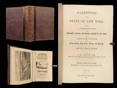
1860 NEW YORK State Gazetteer Geography Americana Colonial USA IllustratedSchilb Antiquarian Rare Books4.8(422)See Sold PriceMar 31, 2024
Group of Ten Railroad Photographs, Maps, and Prints - New Jersey, Long Island, and New YorkRail & Road Auctions4.6(165)See Sold PriceMar 07, 2024
[THEATRE]. MITCHELL, Maggie (1832-1918). Po...Potter & Potter Auctions4.6(544)See Sold PriceMar 07, 2024
Mitchell Robinson Signed Jersey PSA/DNA New York Knicks AutographedMynt Auctions4.6(689)See Sold PriceFeb 24, 2024
Mitchell Robinson Signed Jersey PSA/DNA New York Knicks AutographedMynt Auctions4.6(689)See Sold PriceFeb 25, 2024
Hoyt Wilhelm Signed Mitchell & Ness New York Giants Jersey JSA COAMynt Auctions4.6(689)See Sold PriceFeb 25, 2024
1860 FOREST HYMN by William Cullen Bryant ILLUSTRATED antique POETRYJasper524.5(9.8k)See Sold PriceFeb 27, 2024
1900 THOMAS HENRY HUXLEY SKETCH OF HIS LIFE & WORK P. CHALMERS MITCHELL antiqueJasper524.5(9.8k)See Sold PriceFeb 27, 2024
Mitchell & Ness Joe Namath Football Jersey w/ TagsLegacy Auctions & Estate Sales4.6(72)See Sold PriceFeb 25, 2024
New York Knicks Willis Reed NBA JerseyLegacy Auctions & Estate Sales4.6(72)See Sold PriceFeb 25, 2024
Two Hand-Colored 19th Century Maps of New Orleans and Louisiana, Larger- H.- 12 1/2 in., W.- 15 1/2Crescent City Auction Gallery4.3(231)See Sold PriceMar 08, 2024
Mitchell Robinson Signed Jersey PSA/DNA New York Knicks Autographed3 Kings Auction4.2(197)See Sold PriceFeb 24, 2024
Mitchell Robinson Signed Jersey PSA/DNA New York Knicks Autographed3 Kings Auction4.2(197)See Sold PriceFeb 26, 2024
8PC New York Police Department Guide BooksBruneau & Co. Auctioneers4.5(491)See Sold PriceMar 18, 2024
Dan Budnik, Collection of eleven photographsLos Angeles Modern Auctions4.4(24)See Sold PriceMar 08, 2024
Pennsylvania Railroad and Tunnel Ephemera, 7 Pcs.Auctions at Showplace4.6(731)See Sold PriceFeb 13, 2025


![[MAP] "Plan of New Orleans (1 of 2)](https://p1.liveauctioneers.com/268/960/425616_1_x.jpg?height=282&quality=70)


![[THEATRE]. MITCHELL, Maggie (1832-1918). Po... (1 of 1)](https://p1.liveauctioneers.com/928/318880/171361246_1_x.jpg?height=282&quality=70&version=1707501302)