ATLAS of ANTIENT GEOGRAPHY by SAMUEL BUTLER 1843John McInnis Auctioneers,LLC4.6(502)See Sold PriceFeb 24, 2024
18TH C. ANTIQUE MAP: FRENCH & INDIAN WAR, FRAMEDThomaston Place Auction Galleries4.4(386)See Sold PriceFeb 24, 2024
Rand McNally Railroad Map Cabinet w/ 21 Railroad MapsRail & Road Auctions4.6(165)See Sold PriceMar 08, 2024
Keith Haring - Ink on New York Map, Best Buddies, Inscribed, Signed, and DatedSapphire Auction Gallery4(67)See Sold PriceMar 02, 2024
LATE 17TH C. FRENCH MAP OF THE NEW WORLD BY ALEXIS-HUBERT JAILLOT (1632-1712)Thomaston Place Auction Galleries4.4(386)See Sold PriceFeb 24, 2024
Central Railroad of New Jersey Map of Sandy Hook Route-ca. 1903JM Hobby Supply and Railroad Artifact Auctions4.4(126)See Sold PriceFeb 24, 2024
Lot of Six Mixed Atlas Box Cars-HO Scale-New in BoxJM Hobby Supply and Railroad Artifact Auctions4.4(126)See Sold PriceFeb 25, 2024
Rand McNally/Santa Fe Railroad Map of Iowa-1912JM Hobby Supply and Railroad Artifact Auctions4.4(126)See Sold PriceFeb 24, 2024
NICOLAES VISSCHER (NETHERLANDS, 1618-1709) MAP OF THE NEW WORLDThomaston Place Auction Galleries4.4(386)See Sold PriceFeb 24, 2024
17TH C. WORLD MAP BY NICOLAES VISSCHER (NETHERLANDS, 1618-1709)Thomaston Place Auction Galleries4.4(386)See Sold PriceFeb 24, 2024
Lot of Six Mixed Atlas Cabooses-HO Scale-New in BoxJM Hobby Supply and Railroad Artifact Auctions4.4(126)See Sold PriceFeb 25, 2024
SoldMAP OF "NATIVE RACES OF THE PACIFIC STATES"MAP OF "NATIVE RACES OF THE PACIFIC STATES" Ca. 1880 map of "Native Races of the Pacific States Californian Group", 12" x 9" overall, shows the western part of the U.S. and California in detail with sSee Sold Price
SoldTHE NATIVE RACES OF THE PACIFIC STATES OF NORTH AMTHE NATIVE RACES OF THE PACIFIC STATES OF NORTH AMERICA VOLUMES II-V. Applton, NY, 1875. 1st ed. This is 4 out of 5 volumes, missing volume 1. 805pp+796pp + 807pp +796pp. Includes 4 folding maps and aSee Sold Price
SoldThe Native Races of the Pacific States of North A5 volumes. Maps, some folding, occasional cuts in the text. 9x5½, half gilt-ruled morocco, spines lettered in gilt, raised bands, marbled endpapers & edges. Issued as Vols. I-V of Bancroft's Works. SSee Sold Price
The Native Races of the Pacific States. Bancroft, HuberThe native races of the Pacific States. Bancroft, Hubert Howe. D. Appleton. of North America. By Hubert Howe Bancroft. Volume V. Primitive history. Large 8vo, 796 p. 2 fold. maps, 1/2 morocco, broken.See Sold Price
SoldEthnography, Eight Volumes: Bancroft's Native RacEthnography, Eight Volumes: Bancroft's Native Races of the Pacific States of North America, five vols., 1874; Thirtieth Annual Report of the Bureau of American Ethnology to the Secretary of the SmithsSee Sold Price
Two 19th Century Books Pertaining to Canada's Red Riveras follows: Ross, Alexander. The Red River Settlement; Its Rise, Progress, and Present State. With Some Account of the Native Races and Its General History, to the Present Day. (London: Smith, Elder aSee Sold Price
SoldTwo 19th Century Books Pertaining to Canada's Red RiverTwo 19th Century Books Pertaining to Canada's Red River Settlementas follows: Ross, Alexander. The Red River Settlement; Its Rise, Progress, and Present State. With Some Account of the Native Races anSee Sold Price
SoldBancroft's outline map of Pacific States 1866Heading: Author: Bancroft, Hubert Howe Title: Outline Map of the Pacific States. Designed to accompany Clarke's series of geographies and being no. IV of Bancroft's geographical and historical seriesSee Sold Price
Antique US Map of Territories & Pacific States, 1865Domestic: Free Shipping Item: Old Antique Map of the Western United States Title: Territories & Pacific States to Accompany "Across the Continent" by Samuel Bowles Engraver: J.H. Goldtwhait Printer: GSee Sold Price
SoldPacific States Map A&C Black Edinburgh c1889For your consideration is a Western states atlas map, circa 1889, published by A & C Black, Edinburgh. This Black's General Atlas of the World, American edition, shows the Dakotas as one territory, inSee Sold Price
SoldBancroft, Hubert Howe. The Native Races of the Pacific(New York: D. Appleton & Co., 1874-1876), 5 vols., small quarto (9.25 in.), full calf with gilt spines, an in-depth anthropological study outlining peoples, their history , and material culture. IllusSee Sold Price
SoldAntique US Map of Territories & Pacific States, 1865Domestic: Free ShippingItem: Old Antique Map of the Western United StatesTitle: Territories & Pacific States to Accompany "Across the Continent" by Samuel BowlesEngraver: J.H. GoldtwhaitPrinter: G.W.See Sold Price
SoldBancroft maps of Pacific NorthwestHeading: Author: Bancoft, Hubert Howe Title: Four examples each of the northwest and northeast quadrants of "Bancroft's Map of the Pacific States Compiled by Wm. Henry Knight" - various issues PlaceSee Sold Price
SoldBancroft's Pacific States 1867Heading: Author: Bancroft, Hubert Howe Title: Bancroft's Map of the Pacific States Place Published: San Francisco Publisher:H.H. Bancroft & Co. Date Published: 1867 Description:See Sold Price
SoldRare Colton folding map of Pacific Slope 1862Heading: Author: Colton, Joseph Hutchins Title: Colton's Map of the Pacific States California and Oregon with the Territories of Nevada, Utah, New Mexico, Colorado and Washington, in connection withSee Sold Price
SoldFolding map of West with railroads 1876Heading: Author: Watson, Gaylord Title: Watson's New County and Railroad Map of the Pacific States Place Published: New York Publisher:Published by G. Watson Date Published: 1876 DescrSee Sold Price
SoldBancroft's Pacific States on 4 sheets 1867Heading: Author: Bancroft, Hubert Howe Title: Bancroft's Map of the Pacific States Compiled by Wm. Henry Knight Place Published: San Francisco Publisher:H.H. Bancroft & Company Date Published: <See Sold Price
Bowles: Map of the Territories & Pacific States, 1865Map Title: Map of the Territories & Pacific States to Accompany 'Across The Continent Maker: Samuel Bowles Publisher: Colton, G.W. & C.B., Goldthwait, J.H. Publishing Date: 1865 Size: Folio - 13.50 xSee Sold Price
SoldGeneral Map of the North Pacific States and TerritoriesJohn Mullan (1830-1909). New York: Wm. M. Franklin, 1865. Engraved map with original hand color. 25 x 39 inches visible, 29 1/2 x 44 inches framed.See Sold Price
1882 Map of the US Pacific StatesTitle: 1882 Map of the US Pacific States Author: Blackie Medium: Ink on Paper Dimensions: 11"X15" Description: Map of the US Pacific Coast states dated 1882. Part of the Comprehensive Atlas & GeographSee Sold Price
SoldMap of Routes for a Pacific Railroad, 1855On the Track of Manifest Destiny 117. [MAP: PACIFIC RAILROAD SURVEY]. UNITED STATES. ARMY. CORPS OF TOPGRAPHICAL ENGINEERS. [WARREN, Gouverneur Kemble]. Map of Routes for a Pacific Railroad Compiled tSee Sold Price
Map of the Territories and Pacific StatesTitle/Content of Map: Map of the Territories and Pacific States Cartographer: COLTON, G.W. & C.B. Date: 1868 Publisher: HURD & HOUGHTON Size: 13.5Height - 18Width "to accompany "Across the continent"See Sold Price
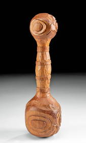
SoldEarly 20th C. Native American Tlingit Wooden PaddleNative American, Pacific Northwest Coast, United States and Canada, Tlingit people ca. 1940s CE. A fine ceremonial canoe paddle, hand-carved from red cedar wood, with stylized zoomorphic forms on theSee Sold Price
SoldEarly 20th C. Tlingit Cedar Canoe Paddle w/ Eagle MotifNative American, Pacific Northwest Coast, United States and Canada, Tlingit people ca. early to mid 20th century CE. A fine ceremonial canoe paddle, hand-carved from red cedar wood, with the relief ofSee Sold Price
Northern Pacific RR Washington and Northern Idaho Map Folder-1941JM Hobby Supply and Railroad Artifact Auctions4.4(126)See Sold PriceFeb 24, 2024
Union Pacific RR Map of the United States-1926JM Hobby Supply and Railroad Artifact Auctions4.4(126)See Sold PriceFeb 24, 2024
Rock Island RR Iowa and Minnesota Lakes Country Brochure-1926JM Hobby Supply and Railroad Artifact Auctions4.4(126)See Sold PriceFeb 24, 2024
EARLY 18TH C. DUTCH CHART OF PACIFIC OCEAN BY FREDERIK DE WIT (1629-1706) WITH CALIFORNIA AS ANThomaston Place Auction Galleries4.4(386)See Sold PriceFeb 24, 2024
Cooke, George 1801 Antique Map. United States of AmericaAlbion Auctions4.6(336)See Sold PriceMar 01, 2024
Blackie (Pub) 1882 Folio Map. West USA - Pacific StatesAlbion Auctions4.6(336)See Sold PriceMar 01, 2024
Blackie (Pub) 1882 Folio Map. United States of North AmericaAlbion Auctions4.6(336)See Sold PriceMar 01, 2024
Robert de Vaugondy - Map of Canada - Mer de l' Ouest or Sea of the West and a Northwest PassageProverde Auctions4.3(3)See Sold PriceFeb 28, 2024