SoldFolding map of West with railroads 1876Heading: Author: Watson, Gaylord Title: Watson's New County and Railroad Map of the Pacific States Place Published: New York Publisher:Published by G. Watson Date Published: 1876 DescrSee Sold Price
SOUTH WEST ASIA. 'Persia, Afghanistan & Beloochistan'. Iran 1876 old mapTITLE/CONTENT OF MAP: 'Persia, Afghanistan & Beloochistan' DATE PRINTED: 1876 IMAGE SIZE: Approx 24.0 x 30.5cm, 9.25 x 12 inches (Large); Please note that this is a folding map. TYPE: Antique colour mSee Sold Price
1876 Colton Folding Map of the Western United States1876 Colton Folding Map of the Western United States -- Colton's Map of the States and Territories West of the Mississippi River to the Pacific Ocean Showing the Overland Routes, Projected Rail Road LSee Sold Price
Colton: Antique Map of the Western United States, 1876Map: 1876 Colton Folding Map of the Western United States -- Colton's Map of the States and Territories West of the Mississippi River to the Pacific Ocean Showing the Overland Routes, Projected Rail RSee Sold Price
Colton: Folding Map of the Western United States, 1876Map: 1876 Colton Folding Map of the Western United States -- Colton's Map of the States and Territories West of the Mississippi River to the Pacific Ocean Showing the Overland Routes, Projected Rail RSee Sold Price
Colton: Antique Folding Map Western United States, 1876Title/Content of Map: 1876 Colton Folding Map of the Western United States -- Colton's Map of the States and Territories West of the Mississippi River to the Pacific Ocean Showing the Overland Routes,See Sold Price
Sold1876 Colton Folding Map of the Western United States --Title/Content of Map: 1876 Colton Folding Map of the Western United States -- Colton's Map of the States and Territories West of the Mississippi River to the Pacific Ocean Showing the Overland Routes,See Sold Price
1876 Colton's United States Folding MapColton's New Map of County & Railroads of the United States and Canada. The frame measures 35.5" x 46.25". The map measures 32 5/8" x 43".See Sold Price
1876 Colton Antique Folding Map of the Western USTitle/Content of Map: 1876 Colton Folding Map of the Western United States -- Colton's Map of the States and Territories West of the Mississippi River to the Pacific Ocean Showing the Overland Routes,See Sold Price
1876 Colton Folding Map of the Western United StatesTitle/Content of Map: 1876 Colton Folding Map of the Western United States -- Colton's Map of the States and Territories West of the Mississippi River to the Pacific Ocean Showing the Overland Routes,See Sold Price
Virginia and West VirginiaReserve Reduced! Title: Virginia and West Virginia Publication Date: c1904 Cartographer: CRAM, GEORGE F. Publisher: GEO. F. CRAM Size: 21.75 X 31.75 Large detailed folding map that shows all railroadsSee Sold Price
SoldCentral Pacific Railroad Time Table and Map, c. 1876Fabulous piece for the railroad collector. One side is a wonderful color map of the West: Williams' New Transcontinental Map of The Pacific R.R. and Routes of Overland Travel to Colorado, Nebraska, ThSee Sold Price
SoldAmerican Railways.-Poor (Henry V.) Manual of the RAmerican Railways.-Poor (Henry V.) Manual of the Railroads of the United States,for the years 1875-1876; 1882 and 1896, large folding map to 1875 vol., other vol. with colour maps, most doubleSee Sold Price
SoldU. S. Geographical... Topographical Atlas Sheets.[Natural History/Geology] U. S. GEOGRAPHICAL SURVEYS WEST OF 100th MERIDIAN: TOPOGRAPHICAL ATLAS SHEETS. Wheeler. 1876. Atlas is 7 folding maps in ¼ cloth and printed paper covered board. Maps mostlySee Sold Price
SoldWest Shore Railroad Timetable and 1888 Booklet2 paper items from the New York West Shore & Buffalo Railroad: (1) undated folding timetable - tape repairs - just fair condition (2) great condition 1888 book with fold out map. - fine condition.See Sold Price
Sold1740 Detailed Folding Map West Indies and America“An Accurate Map of the West Indies Exhibiting not only all the Islands possess’d by the English, French, Spaniards and Dutch but also all the Towns and Settlements on the Continet of America AdjaSee Sold Price
SoldRARE 1852 CASE TIFFANY & CO. MAP OF U.S.Dated 1851 to portrait of Washington, capital added 1852. Hand-colored engraving of folding map, West in territories. Dimensions: (Frame) H 27.25" x W 29.25", (Sight) H 22.75" x W 25" Condition: ColorSee Sold Price
SoldCivil War Manuscript Map, West TN RailroadsCivil War era ink on laid paper hand drawn map depicting West Tennessee and Northern Mississippi and Alabama. The strategical map focuses on towns, cities, and railroad stations and their positions alSee Sold Price
Colton's 1857 Township Map of New York StateHistoric Maps 1857 Township Map of the State of New York by Colton 1857-Dated, Publisher's Brown Cloth Covered Pocket Folding Map, "Colton's Railroad & Township Map of the State of New York with PartsSee Sold Price
Sold1864 FOLDING MAP OF THE RAILROADS OF NEW YORK, SOME1864 FOLDING MAP OF THE RAILROADS OF NEW YORK, SOME CREASE TEARS AND SOME OD TAPE ON SOME CREASES. MEASURES 25" X 29". WEED, PARSONS & CO. ALBANY, N.Y.See Sold Price
SoldMap of western railroads 1876Title: Williams' New Trans-Continental Map of the Pacific R.R. and Routes of Overland Travel to Colorado, Nebraska, the Black Hills, Utah, Idaho, Nevada, Montana, California and the Pacific Coast AuthSee Sold Price
SoldLarge folding railroad map of North America 1891Heading: (North America) Author: Rand, McNally & Co. Title: Rand, McNally & Co.'s New Official Railroad Map of the United States Canada & Mexico Place Published: Chicago Publisher: Date PublishedSee Sold Price
SoldAN 1876 RAILROAD MAP OF KENTUCKY AND TENNESSEEFrank A. Gray railroad map of Kentucky and Tennessee, printed by O.W. Gray, Phila. Professionally matted, 16.75 x 23.25 inch sight size.See Sold Price
Large folding railroad map of North America 1891Title: Rand, McNally & Co.'s New Official Railroad Map of the United States Canada & Mexico Author: Rand, McNally & Co. Description: Color lithographed map. 80.5x112 cm. (31¾x44"), sectioned and backSee Sold Price
EARLY COLONIAL WEST AFRICA. Empires of Sokoto Gando Mas.Tribes.Fellatah 1882 mapJasper524.5(9.9k)See Sold PriceFeb 28, 2024
AFRICA. French West Africa. Rio de Oro Rio Muni Nigeria. BARTHOLOMEW 1952 mapJasper524.5(9.9k)See Sold PriceFeb 28, 2024
NORTH & COLONIAL WEST AFRICA. Nigeria marked as "Royal Niger Company" 1898 mapJasper524.5(9.9k)See Sold PriceFeb 28, 2024
WEST AFRICA. British Cameroons & Togoland mandates. Gold Coast Nigeria 1947 mapJasper524.5(9.9k)See Sold PriceFeb 28, 2024
Morocco Algeria. French & Spanish West Africa. Sahara sand dunes. TIMES 1956 mapJasper524.5(9.9k)See Sold PriceFeb 28, 2024
FRENCH WEST AFRICA. Afrique Occidentale Française. Saint-Louis, Senegal 1931 mapJasper524.5(9.9k)See Sold PriceFeb 28, 2024
NORTH & WEST AFRICA. Gold Coast (Ghana) Slave Coast. Tribal names 1890 mapJasper524.5(9.9k)See Sold PriceFeb 28, 2024
AFRICA. Pre 'Scramble for Africa'. BARTHOLOMEW 1876 old antique map plan chartJasper524.5(9.9k)See Sold PriceFeb 28, 2024
FRENCH WEST AFRICA. Afrique Occidentale Française. Saint-Louis, Senegal 1938 mapJasper524.5(9.9k)See Sold PriceFeb 28, 2024
WEST AFRICA. European colonies; Mauritius; Ascension; St Helena 1907 old mapJasper524.5(9.9k)See Sold PriceFeb 28, 2024
Colonial & French West Africa. Gold Coast Dahomey Upper Volta. TIMES 1922 mapJasper524.5(9.9k)See Sold PriceFeb 28, 2024
FRENCH WEST AFRICA. Afrique Occidentale Française. Saint-Louis, Senegal 1929 mapJasper524.5(9.9k)See Sold PriceFeb 28, 2024
FRENCH WEST AFRICA. Afrique Occidentale Française. Plan of Niger floods 1938 mapJasper524.5(9.9k)See Sold PriceFeb 28, 2024
North & West Africa. Dahomey. Gold Coast. Military Territory. THE TIMES 1922 mapJasper524.5(9.9k)See Sold PriceFeb 28, 2024
Partie Occidentale de l’Afrique. West Africa coast Canary islands BONNE 1788 mapJasper524.5(9.9k)See Sold PriceFeb 28, 2024
FRENCH WEST AFRICA. Afrique Occidentale Française. Plan of Niger floods 1929 mapJasper524.5(9.9k)See Sold PriceFeb 28, 2024
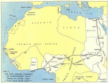
West Africa WW2 Nigeria Sudan Egypt. Takoradi air reinforcement route 1954 mapJasper524.5(9.9k)See Sold PriceFeb 28, 2024
FRENCH WEST AFRICA Nigeria Gold Coast Rio de Oro Portuguese Guinea 1912 mapJasper524.5(9.9k)See Sold PriceFeb 28, 2024
French West Africa. Gold Coast. Sahara desert sand dunes. TIMES 1956 mapJasper524.5(9.9k)See Sold PriceFeb 28, 2024
EARLY COLONIAL WEST AFRICA. Empires of Sokoto Gando Mas.Tribes.Fellatah 1886 mapJasper524.5(9.9k)See Sold PriceFeb 28, 2024